


Angleton residents clean up after storm damages
Angleton is cleaning up the damages left behind after a devastating storm wrecked the town. FOX 26's Jade Flury reports after speaking to residents.
Angleton is cleaning up the damages left behind after a devastating storm wrecked the town. FOX 26's Jade Flury reports after speaking to residents.

FOX 26 Houston Weather Forecast
Sunday is once again a FOX 26 Storm Alert Day. A few showers and storms are possible this evening through early tonight. The severe threat through early tonight appears to be pretty low. But models are showing another big round of heavy rain and strong storms moving in from the west early Sunday morning. Timing for this appears to be from around 3-9 AM. More heavy downpours, strong winds near 60 mph and some hail will be possible. A cold front remains stalled near Houston and we will get more waves of rain through Sunday evening. But Sunday night, cold front pushes south of us ushering in cooler and drier air. That means a pleasant and brighter start to the work week on Monday. Tuesday should be mild and dry but rain and storms are back with our next system by the middle of next week. Make sure to download the Fox 26 News App and Weather App to get updates on weather that could impact your St. Patrick's Day or final day of rodeo plans! Also check out our smart tv streaming app FOX Local for extended coverage if storms turn severe!
Sunday is once again a FOX 26 Storm Alert Day. A few showers and storms are possible this evening through early tonight. The severe threat through early tonight appears to be pretty low. But models are showing another big round of heavy rain and strong storms moving in from the west early Sunday morning. Timing for this appears to be from around 3-9 AM. More heavy downpours, strong winds near 60 mph and some hail will be possible. A cold front remains stalled near Houston and we will get more waves of rain through Sunday evening. But Sunday night, cold front pushes south of us ushering in cooler and drier air. That means a pleasant and brighter start to the work week on Monday. Tuesday should be mild and dry but rain and storms are back with our next system by the middle of next week. Make sure to download the Fox 26 News App and Weather App to get updates on weather that could impact your St. Patrick's Day or final day of rodeo plans! Also check out our smart tv streaming app FOX Local for extended coverage if storms turn severe!

Storm rips through Angelton golf driving range
A storm ripped through the building of an Angelton golf driving range.
A storm ripped through the building of an Angelton golf driving range.
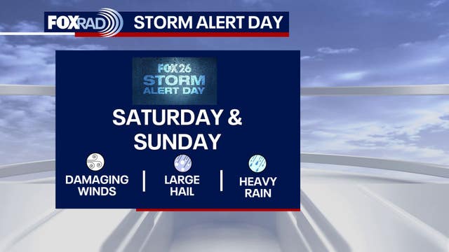

Houston weather: Hail expected in Houston-area through Sunday
Heavy rain, frequent lighting, strong winds and hail expected through Sunday evening in Houston.
Heavy rain, frequent lighting, strong winds and hail expected through Sunday evening in Houston.

FOX 26 Houston Weather Forecast
Saturday and Sunday are FOX 26 Storm Alert Days. We are monitoring the chance for several rounds of rain and a few strong storms this weekend. A front remains stalled over southeast Texas. This front keeps the threat of heavy rain, frequent lightning, strong winds, and hail through Sunday evening in Houston. The Storm Prediction Center keeps the southern portion of our viewing area in a 2/5 'Likely' risk for hail and strong winds. The Flood Threat remains widespread across the viewing area as an additional 1-3" of rain in total. Keep your umbrella handy, especially if you are heading out to the last weekend of the rodeo. Between the rounds of rain and storms, it will be humid with highs in the mid-60s and muggy conditions. A reinforcing cold front will finally sweep across the state helping to clear out the rain and drop temperatures back to the 60s to start next week.
Saturday and Sunday are FOX 26 Storm Alert Days. We are monitoring the chance for several rounds of rain and a few strong storms this weekend. A front remains stalled over southeast Texas. This front keeps the threat of heavy rain, frequent lightning, strong winds, and hail through Sunday evening in Houston. The Storm Prediction Center keeps the southern portion of our viewing area in a 2/5 'Likely' risk for hail and strong winds. The Flood Threat remains widespread across the viewing area as an additional 1-3" of rain in total. Keep your umbrella handy, especially if you are heading out to the last weekend of the rodeo. Between the rounds of rain and storms, it will be humid with highs in the mid-60s and muggy conditions. A reinforcing cold front will finally sweep across the state helping to clear out the rain and drop temperatures back to the 60s to start next week.


Houston weather: TDEM provides update after severe storm damage
Governor Greg Abbott shared the update he received from the Texas Division of Emergency Management on damages for Austin County and Bellville.
Governor Greg Abbott shared the update he received from the Texas Division of Emergency Management on damages for Austin County and Bellville.
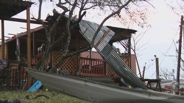

Houston weather: Golf ball size hail, Strong wind cause extensive damage in Bellville
Bellville, a city of 4,200 people and an hour and seven minutes west of Houston, had extensive damage from golf-size hail and strong winds.
Bellville, a city of 4,200 people and an hour and seven minutes west of Houston, had extensive damage from golf-size hail and strong winds.

FOX 26 Houston Weather Forecast
After a round of severe storms Friday evening, get ready for more waves of rain and storms Saturday and Sunday. Saturday and Sunday are still FOX 26 Storm Alert Days with heavy rain likely along with a few strong storms. Cold front will remain stalled over SE Texas this weekend leading to rounds of heavy downpours and a few additional strong storms. Severe threat should be lower the next few days but the flood risk will be higher. Watch out for street flooding that could cause problems for your weekend rodeo and St. Patrick's Day plans. Additional 1-3" rain will be possible for parts of SE Texas over the weekend. So keep the rain gear close and watch out for any flooded roads. Severe storm risk for Saturday and Sunday will be lower but is still possible. Cold front finally pushes through by Sunday evening ushering in cooler and drier air for early next week. Make sure to download the Fox 26 News App and Weather App to get frequent updates on weather that could impact your spring break or rodeo plans! Also check out our smart tv streaming app FOX Local for extra severe weather coverage during this event!
After a round of severe storms Friday evening, get ready for more waves of rain and storms Saturday and Sunday. Saturday and Sunday are still FOX 26 Storm Alert Days with heavy rain likely along with a few strong storms. Cold front will remain stalled over SE Texas this weekend leading to rounds of heavy downpours and a few additional strong storms. Severe threat should be lower the next few days but the flood risk will be higher. Watch out for street flooding that could cause problems for your weekend rodeo and St. Patrick's Day plans. Additional 1-3" rain will be possible for parts of SE Texas over the weekend. So keep the rain gear close and watch out for any flooded roads. Severe storm risk for Saturday and Sunday will be lower but is still possible. Cold front finally pushes through by Sunday evening ushering in cooler and drier air for early next week. Make sure to download the Fox 26 News App and Weather App to get frequent updates on weather that could impact your spring break or rodeo plans! Also check out our smart tv streaming app FOX Local for extra severe weather coverage during this event!

Weather causes damage in Needville community
Severe storms also hit Fort Bend County and FOX 26's Jonathan Mejia has more team coverage from Needville.
Severe storms also hit Fort Bend County and FOX 26's Jonathan Mejia has more team coverage from Needville.

Bellville hit with golf ball size hail, strong winds
Bellville, a city of 4,200 people and an hour and seven minutes west of Houston, had extensive damage from golf size hail and strong winds. FOX 26's Randy Wallace has more.
Bellville, a city of 4,200 people and an hour and seven minutes west of Houston, had extensive damage from golf size hail and strong winds. FOX 26's Randy Wallace has more.


Houston rodeo carnival back open after severe weather
The gates to NRG Stadium for the rodeo and Jonas Brothers concerts will start on time at 6:45 pm as scheduled.
The gates to NRG Stadium for the rodeo and Jonas Brothers concerts will start on time at 6:45 pm as scheduled.
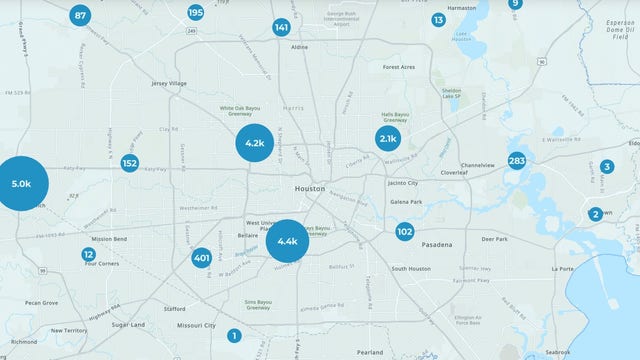

Houston weather: Power outages for more than 11K CenterPoint Energy customers
Thousands of CenterPoint Energy customers are without power as heavy rain and hail impact the Houston area.
Thousands of CenterPoint Energy customers are without power as heavy rain and hail impact the Houston area.

Houston rodeo impacted by severe storms
Hold on to your cowboy hats as storms rain down on the final weekend of the rodeo! FOX 26's Jade Flury is at the fairgrounds with response from attendees.
Hold on to your cowboy hats as storms rain down on the final weekend of the rodeo! FOX 26's Jade Flury is at the fairgrounds with response from attendees.

Houston weather: Severe thunderstorm warning issued for Harris County, surrounding areas
The National Weather Service has issued a severe thunderstorm warning for several counties in the Houston area on Friday.
The National Weather Service has issued a severe thunderstorm warning for several counties in the Houston area on Friday.

What is hail? How does it form?
We are at risk for heavy rain and even hail today. Some large hail is possible and that?s pretty rare. Chief Meteorologist Mike Iscovitz explains what hail is and why we?re concerned.
We are at risk for heavy rain and even hail today. Some large hail is possible and that?s pretty rare. Chief Meteorologist Mike Iscovitz explains what hail is and why we?re concerned.
Houston weather: Friday, weekend forecast includes heavy rain, storms
The risk for isolated to strong severe storms are possible on Friday as a stalled front moves through the Houston area.
The risk for isolated to strong severe storms are possible on Friday as a stalled front moves through the Houston area.

FOX 26 Houston Weather Forecast
Today, tomorrow and Sunday are FOX 26 Storm Alert Days, which means that significant weather impacts are possible. This time, watch for scattered storms that could produce lots of lightning, heavy rain and even isolated hail. Rain totals could exceed 3-4", but rain will come through in waves with cloudy, humid weather in between. Check your FOX 26 weather app if you're headed to the rodeo since storms are possible.
Today, tomorrow and Sunday are FOX 26 Storm Alert Days, which means that significant weather impacts are possible. This time, watch for scattered storms that could produce lots of lightning, heavy rain and even isolated hail. Rain totals could exceed 3-4", but rain will come through in waves with cloudy, humid weather in between. Check your FOX 26 weather app if you're headed to the rodeo since storms are possible.

FOX 26 Houston Weather Forecast
Friday, Saturday, and Sunday are now FOX 26 Storm Alert Days with the threat for a few severe storms and flooding. Make sure to download the Fox 26 News App and Weather App to get frequent updates on weather that could impact your spring break or rodeo plans! Also, check out our smart tv streaming app FOX Local for extra severe weather coverage during this event! A cold front will drop into Houston Friday and stall over the weekend. That will mean several rounds of rain Friday through Sunday with 1-3" likely with isolated higher amounts. Main severe threat will be Friday PM with hail and strong winds possible. Biggest threat will remain west of Houston around Brenham, Sealy & Columbus. Flood threat will be highest Friday near and north of I-10. An elevated flood risk will stick around for Saturday and Sunday with some flood advisories possible. Cold front finally pushes through by Sunday evening ushering in drier and slightly cooler air the early next week.
Friday, Saturday, and Sunday are now FOX 26 Storm Alert Days with the threat for a few severe storms and flooding. Make sure to download the Fox 26 News App and Weather App to get frequent updates on weather that could impact your spring break or rodeo plans! Also, check out our smart tv streaming app FOX Local for extra severe weather coverage during this event! A cold front will drop into Houston Friday and stall over the weekend. That will mean several rounds of rain Friday through Sunday with 1-3" likely with isolated higher amounts. Main severe threat will be Friday PM with hail and strong winds possible. Biggest threat will remain west of Houston around Brenham, Sealy & Columbus. Flood threat will be highest Friday near and north of I-10. An elevated flood risk will stick around for Saturday and Sunday with some flood advisories possible. Cold front finally pushes through by Sunday evening ushering in drier and slightly cooler air the early next week.

FOX 26 Houston Weather Forecast
Friday, Saturday, and Sunday are now FOX 26 Storm Alert Days with the threat of a few severe storms and flooding. Make sure to download the Fox 26 News App and Weather App to get frequent updates on weather that could impact your spring break or rodeo plans! Also, check out our smart tv streaming app FOX Local for extra severe weather coverage during this event! A cold front will drop into Houston Friday and stall over the weekend. That will mean several rounds of rain Friday through Sunday with 1-3" likely with isolated higher amounts. The main severe threat will be Friday PM with hail and strong winds possible. The biggest threat will remain west of Houston around Brenham, Sealy & Columbus. Flood threat will be highest Friday near and north of I-10. An elevated flood risk will stick around for Saturday and Sunday with some flood advisories possible. Cold front finally pushes through by Sunday evening ushering in drier and slightly cooler air the early next week.
Friday, Saturday, and Sunday are now FOX 26 Storm Alert Days with the threat of a few severe storms and flooding. Make sure to download the Fox 26 News App and Weather App to get frequent updates on weather that could impact your spring break or rodeo plans! Also, check out our smart tv streaming app FOX Local for extra severe weather coverage during this event! A cold front will drop into Houston Friday and stall over the weekend. That will mean several rounds of rain Friday through Sunday with 1-3" likely with isolated higher amounts. The main severe threat will be Friday PM with hail and strong winds possible. The biggest threat will remain west of Houston around Brenham, Sealy & Columbus. Flood threat will be highest Friday near and north of I-10. An elevated flood risk will stick around for Saturday and Sunday with some flood advisories possible. Cold front finally pushes through by Sunday evening ushering in drier and slightly cooler air the early next week.

Storm Alert Days: Forecast Friday through Sunday
A cold front moves in and stalls Friday through Sunday, so scattered heavy downpours will be possible each day. FOX 26 Chief Meteorologist Mike Iscovitz has a closer look at the forecast.
A cold front moves in and stalls Friday through Sunday, so scattered heavy downpours will be possible each day. FOX 26 Chief Meteorologist Mike Iscovitz has a closer look at the forecast.