

Texas Winter Storm: Freezing temperatures expected overnight, Friday morning
HOUSTON - Cold air is spilling into the Southeast Texas region as a winter storm that spans nearly 3,000 miles across the U.S. is producing snow, ice, and subfreezing temperatures
Texans will see some of the coldest temperatures in the state since the deadly 2021 winter storm, which left millions without power or water for days. Temperatures will be below freezing each night over the next couple of days and a hard freeze is posted for counties northwest of Houston.
LATEST LOCAL OUTAGES: Texas winter storm brings thousands of power outages
A Winter Weather Advisory is in effect for most of Southeast Texas, including the City of Houston.
So here is the latest on the oncoming weather event:
LATEST FORECAST

Friday Morning Weather Forecast
Roads will be slippery across SE Texas and Houston through midday on Friday. Road conditions will continue to worsen as the temperatures get colder tonight. Temps will be below freezing each night over the next three days and a hard freeze is posted for counties NW of Houston. Be very cautious when driving tonight.
A Wind Chill Advisory is in effect until 9 a.m. Friday morning and the feels like temperatures could range between 10 and 20 degrees.
Early reports to the National Weather Service show sleet west and northwest of Houston. In Brazos County, some icy elevated road conditions have been reported along Highway 21.
More light sleet and freezing rain are still possible, but accumulations should be very light. Nevertheless, any freezing rain could create a glaze of ice on bridges and overpasses north and west of town. Be very cautious when driving at night.
Overnight into Friday morning expect widespread temperatures in the 20s with low to mid-20s expected from The Woodlands northward and Katy westward.
BE PREPARED: With winter weather approaching, remember the 4 P’s
Make sure to bring pets inside, cover or bring in sensitive plants, check in on those who might not have adequate heating, and cover exposed pipes and sprinkler systems outdoors.
CURRENT WEATHER ADVISORIES
Winter Weather Advisory is in effect until 12 p.m. Friday for Colorado, Grimes, Fort Bend, Inland Harris, Montgomery, San Jacinto, Walker, Waller, Washington, and Wharton Counties.
A Wind Advisory is in effect until 6 p.m. Friday for the Brazoria Islands, Bolivar Peninsula Counties, Coastal Jackson, Coastal Matagorda, Galveston Island, and Matagorda Islands.
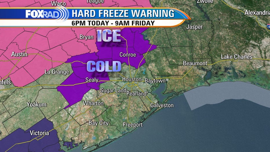
A Hard Freeze Warning is in effect until 12 p.m. Friday for Brazos, Colorado, Grimes, Houston, Montgomery, San Jacinto, Walker, Waller, and Washington Counties.
A Freeze Warning is also in effect until 9 a.m. Friday for the Brazoria Islands.
Wind Chill Advisory is in effect area-wide until noon Friday as ‘feels like’ temperatures will be in the 10-20 degree range, which can be dangerous if people need to be outdoors and aren't properly protected.
RELATED: Governor, ERCOT Chief insist Texas grid is 'ready' for winter storm
FRIGID TEMPERATURES
The main concern for the greater Houston area is the cold air, especially when paired with a harsh north wind.
It won't get as cold or last as long as the 2021 winter storm, but you should still prepare.
RELATED: ERCOT issuing Winter Weather Watch in Texas through Sunday
The entire area will be at or below freezing for at least two nights in a row, and in some areas three nights.
Wind chills are expected in the teens overnight Thursday into Friday. We could see a Wind Chill Advisory with feels like values at or below 13 for parts of the area, in addition to a Hard Freeze for parts of the area.
Winds will relax some as we head into the weekend. It'll still be cold, but less windy so actual temperatures Friday night into Saturday morning will be similar, wind chill values aren't expected to be as low.

Houston area braces for freezing temperatures, freezing roads
FOX 26 Reporter Matthew Seedorff explains several in the Houston area are concerned about wet roads freezing over.
WINDS
Wednesday night through Friday morning, sustained north winds 10 to 20 mph with gusts to 25 to 30 mph are expected.
Not quite wind advisory criteria, though one may be prompted closer to the coastline where slightly higher winds are expected.
CLICK HERE TO DOWNLOAD THE FREE FOX 26 WEATHER APP FOR ALERTS
The FOX 26 Weather App is free and will push any watches, advisories, and warnings right to your phone for your location. If you don't already have it, download it now and activate alerts for your location!
WINTRY PRECIPITATION POSSIBLE
Confidence is increasing that some wintry precipitation will be seen.
Light freezing rain and sleet will be possible, and roads could become slippery.
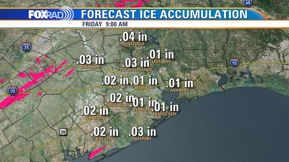
Trace amounts of ice accumulation are expected – 0.01-0.02 inches. There may be some sleet or ice pellets, but the biggest cause for concern would be elevated surfaces such as bridges or overpasses, so exert caution if out on roadways especially during the overnight hours.
CLICK HERE FOR CURRENT WEATHER WARNINGS AND WATCHES
This is still mainly a rain event for the City of Houston and is expected to taper off by Friday evening.
We are expecting under an inch across the board. A couple of isolated thunderstorms may work their way into the mix, but nothing severe is expected.
SCHOOL CLOSINGS / DELAYS
Several Houston-area school districts are announcing closures or delays, including Houston ISD, Aldine ISD, and Klein ISD. There are numerous other school districts that are also closed, Check out the latest list here.
WAYS YOU CAN STAY SAFE
With the arctic blast moving through, there are some steps you can take to make sure you stay safe.
The easiest thing to remember is the 4's: People, plants, pipes, and pets.

Houston Mayor Turner shares city’s response to winter storm
The mayor spoke with FOX 26 to share how the City of Houston is responding to the winter storm.
If you experience any type of power outage or are in need of heat, you can visit one of the open warming centers in the area. Click here for the latest list.
Also, be safe on the roadways. The Houston Police Department is asking that people, when possible, stay off the roads after 10 p.m. Thursday night and into the early morning hours on Friday. HPD says they're working Public Works to identify bridges and overpasses that historically ice over during winter weather. Beginning Thursday evening, Public Works will treat them in anticipation of the road conditions deteriorating.
CLICK HERE FOR THE LATEST FORECAST AND LIVE RADAR
KEY TAKEAWAYS
Plan for three nights of freezing to subfreezing temperatures. Highs will be in the 40s during the afternoon.
There is a chance for some wintry precipitation so be careful on the roadways.
Sunshine should make a return Sunday and temperatures will slowly moderate closer to seasonable for this time of year.