

Houston freeze 2022: Arctic blast timeline for Southeast Texas

Plunging temperature and high winds Thursday afternoon
Prepare for a shocking arrival of wind chills, seriously high winds and two nights of damaging hard freezes. Beginning at noon today, a wind advisory goes into effect as north winds could gust above 40 mph.
HOUSTON - We are only hours away from what will be the biggest surge of chilly air since the "Big Freeze" back in February 2021!
This cold snap thankfully won't last as long or come with any snow or ice, but it will produce dangerous cold that will lead to a widespread hard freeze for multiple nights. Wind gusts near 40 mph will produce the threat of scattered power outages and dangerously low wind chill values.
SUGGESTED: Houston freeze 2022: Weather forecast as arctic blast heads for Southeast Texas
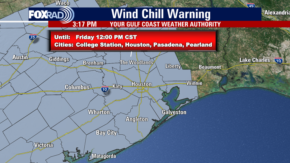
A Hard Freeze Warning is now in effect for Southeast Texas from 6 p.m. Thursday until noon on Saturday. A Wind Chill Warning is in effect from 6 p.m. Thursday to noon Friday. A Wind Advisory is in effect from noon on Thursday until midnight Thursday night inland, but until noon on Friday along the coast.

Although we are not expecting all-time record cold, this will be a cold snap that will have the Houston area 30 to 35 degrees below normal! Here's a timeline of what I'm expecting to happen:
THURSDAY AND FRIDAY
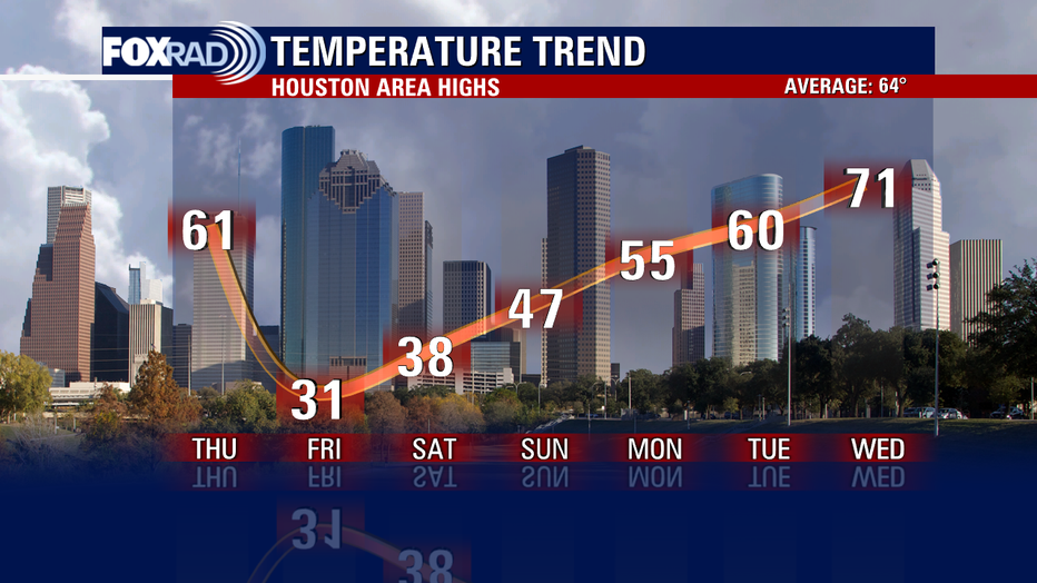
Temperatures will start off in the 40s early and climb to the 60s by early afternoon. The strong arctic will roll in by 1-2 p.m. and send temperatures crashing to the 40s by 3 or 4 p.m. and around freezing by 7 p.m.
RELATED: Texas leaders on arctic blast: 'The power grid is ready and reliable'
Temperatures will bottom out in the teens to low 20s by early Friday morning. On top of that, the wind will pick up switching from the south to the north early Thursday afternoon with gusts of 30-40 mph inland and 40-50 mph along the coast. Make sure to bring in any Christmas inflatables or other loose or lightweight objects that could get blown around!
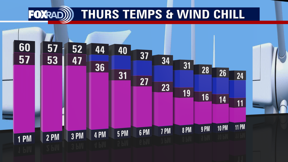
That wind could cause scattered power outages and will send our wind chill or "feels like" temp down to near zero early Friday. Friday morning will likely be the coldest air of this entire event with Houston expected to dip to around 18 degrees with a wind chill between 0 and 5 degrees! Even with lots of sunshine, we will only rebound to the low 30s by Friday afternoon.
READ MORE STORIES TO KEEP TRACK OF THE ARCTIC BLAST
Another widespread hard freeze is likely on Friday night with temperatures once again dipping to the teens and 20s, but there will not be as much wind though.
SATURDAY
We will start off with a widespread hard freeze Saturday with temps in the teens and 20s. However, with abundant sunshine, we should at least make it back to above freezing by the afternoon in the upper 30s and wind should be out of the north around 10-15 mph.
RELATED: Preparing your vehicle for the winter freeze, what you need to know
Another freeze is expected Christmas Eve night with temperatures in the upper 20s for Houston.
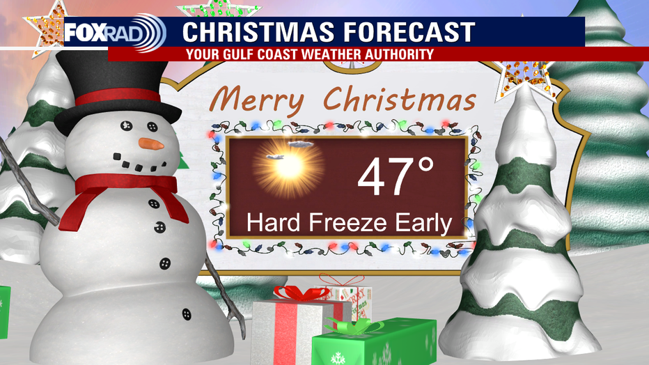
SUNDAY (Christmas Day)
After starting off with temperatures in the 20s Christmas morning, we should rebound all the way to the upper 40s by Sunday afternoon. That is still 15-20 degrees below normal but an improvement! It will be beautiful and bright for Christmas with abundant sunshine. There won't be much wind either coming in out of the northeast around 5-10 mph.
It's important to have your winter weather preps complete by Thursday morning! Make sure your pipes are covered, and it's also a good idea to let your faucets drip during the freezing weather. We will likely stay below freezing for 36-46 hours, so make sure your home is winterized, and you are prepared to cover as much of your skin as possible.
Also, ensure your pets are safe and warm and plants are protected. The cold won't stick around for long because our weather models are already hinting at the 70s by the middle of next week! Stay safe and happy holidays!