

Houston weather: June 28 evening forecast
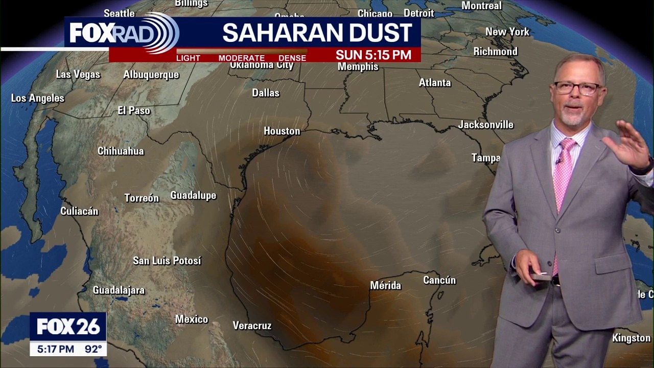
FOX 26 meteorologist John Dawson shares the latest timeline for Saharan Dust coming to Houston, and he has details on the next full moon you can see Monday night.
FOX 26 meteorologist John Dawson shares the latest timeline for Saharan Dust coming to Houston, and he has details on the next full moon you can see Monday night.


Houston weather: Feeling the heat for Sunday; more dust expected Monday
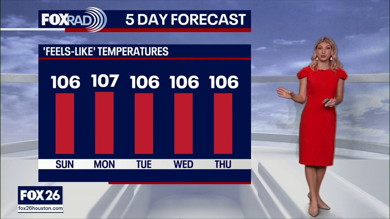
Typical June heat continues across Houston for Sunday and again for Monday’s World Cup match.
Typical June heat continues across Houston for Sunday and again for Monday’s World Cup match.
Houston weather: June 28 morning forecast
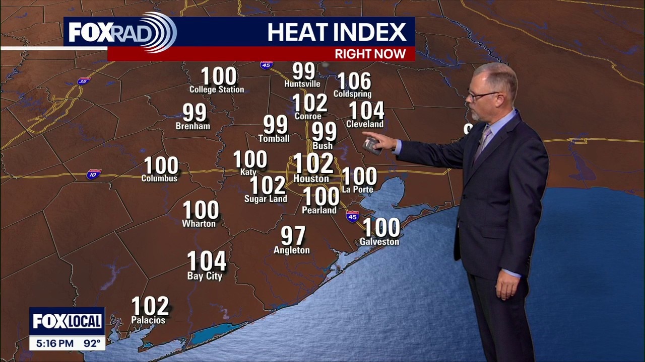
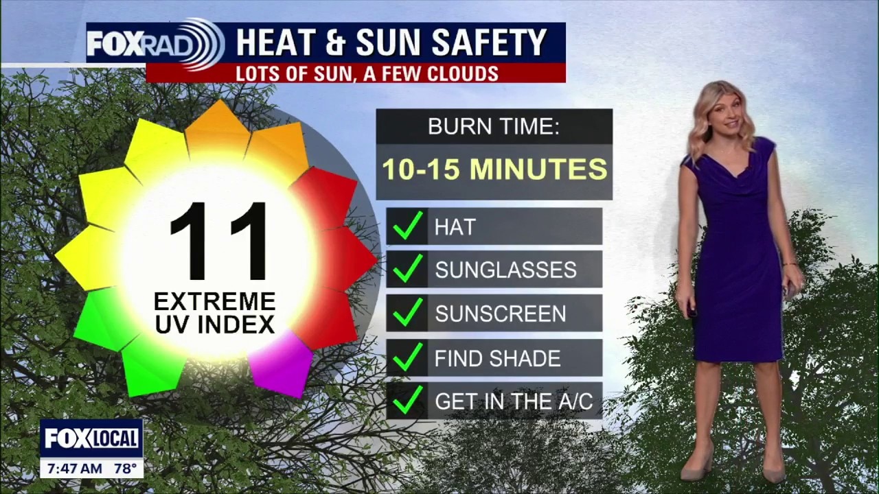
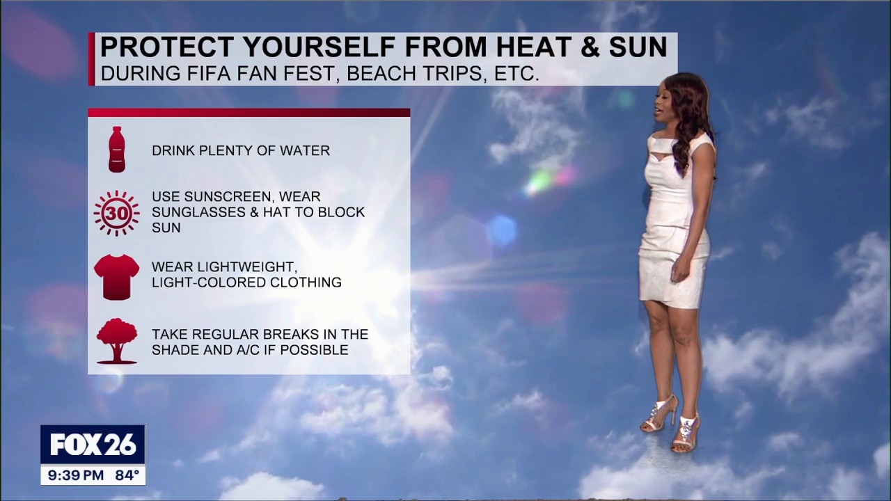
Typical June heat continues across Houston through the weekend and again for Monday’s World Cup Match. Highs stay in the 90s with heat index values above 100 each afternoon, so fans heading to the stadium or FIFA Fan Fest should plan for steamy conditions.
Typical June heat continues across Houston through the weekend and again for Monday’s World Cup Match. Highs stay in the 90s with heat index values above 100 each afternoon, so fans heading to the stadium or FIFA Fan Fest should plan for steamy conditions.

Houston weather: June 27 overnight forecast
FOX 26's John Dawson gives the latest weather forecast and tropical outlook for what is to come for Southeast Texas.
FOX 26's John Dawson gives the latest weather forecast and tropical outlook for what is to come for Southeast Texas.
Houston weather: June 27 evening forecast
Typical June heat continues across Houston through the weekend and again for Monday’s World Cup Match.
Typical June heat continues across Houston through the weekend and again for Monday’s World Cup Match.


Utah wildfire grows rapidly, forcing more evacuations
A fast-moving wildfire in southern Utah grew rapidly overnight, fueled by intense heat, strong winds, and extremely dry conditions, prompting additional evacuation orders.
A fast-moving wildfire in southern Utah grew rapidly overnight, fueled by intense heat, strong winds, and extremely dry conditions, prompting additional evacuation orders.


Houston weather: Heat, haziness continues for the weekend
Hazy skies and high temps continue as we're expecting the thickest batch of Saharan Dust late this weekend for southeast Texas.
Hazy skies and high temps continue as we're expecting the thickest batch of Saharan Dust late this weekend for southeast Texas.
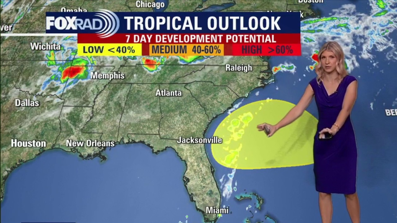
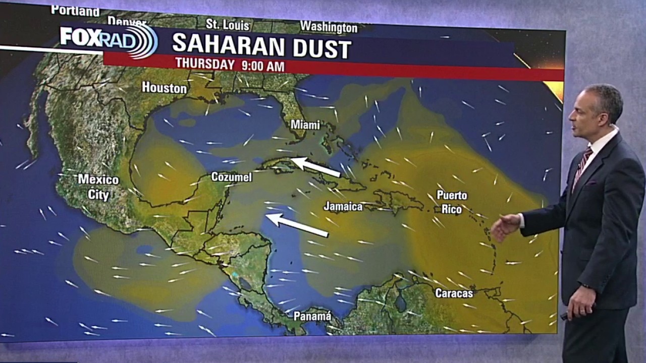
Tropical Weather Forecast: Sarahan Dust timing + new development potential
FOX 26 meteorologist Allison Gargaro gives the latest timing for Sarahan Dust heading to southeast Texas. She's also tracking a new tropical development in the southeast US.
FOX 26 meteorologist Allison Gargaro gives the latest timing for Sarahan Dust heading to southeast Texas. She's also tracking a new tropical development in the southeast US.
Houston weather: June 27 morning forecast
Typical June heat continues across Houston through the weekend and again for Monday’s World Cup Match. Highs stay in the 90s with heat index values above 100 each afternoon, so fans heading to the stadium or FIFA Fan Fest should plan for steamy conditions.
Typical June heat continues across Houston through the weekend and again for Monday’s World Cup Match. Highs stay in the 90s with heat index values above 100 each afternoon, so fans heading to the stadium or FIFA Fan Fest should plan for steamy conditions.
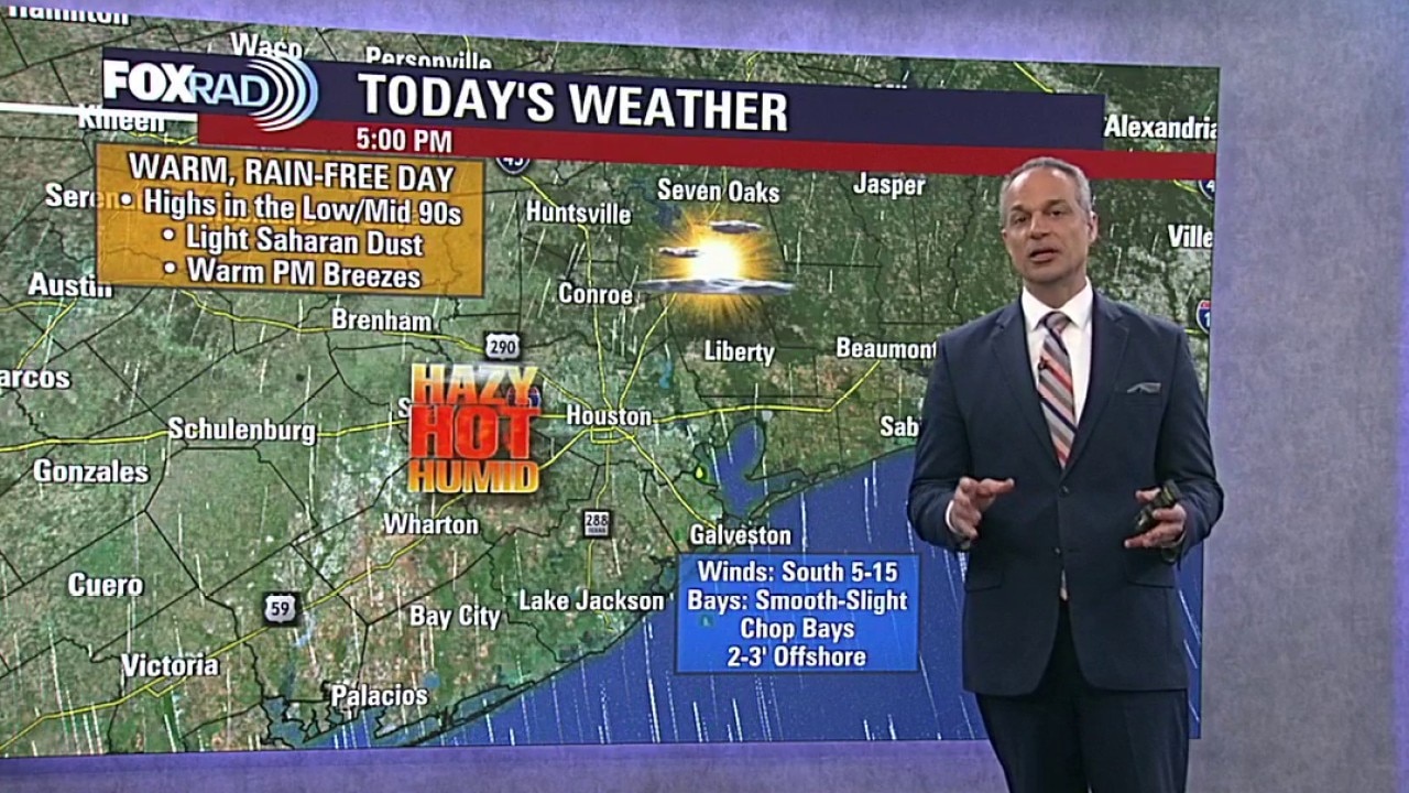
Houston weather: Hot weekend ahead in Houston
Saharan dust remains likely across Southeast Texas, which could give the sky a hazy or milky look at times. Expect a noticeable increase in hazy skies on Monday with the thickest plume of dust moving overhead. Rain chances stay low, but the heat and humidity will make it feel more uncomfortable during the afternoon and early evening.
Saharan dust remains likely across Southeast Texas, which could give the sky a hazy or milky look at times. Expect a noticeable increase in hazy skies on Monday with the thickest plume of dust moving overhead. Rain chances stay low, but the heat and humidity will make it feel more uncomfortable during the afternoon and early evening.
Houston weather: Keeping the heat for the weekend
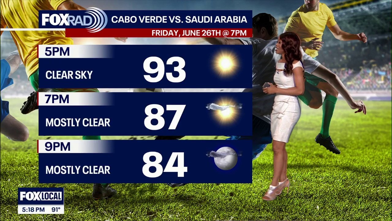
Typical June heat continues across Houston for tonight’s World Cup match.
Typical June heat continues across Houston for tonight’s World Cup match.


Houston weather: Hot, warm temperatures expected through the weekend
The heat will be on for much of the weekend across the Houston area.
The heat will be on for much of the weekend across the Houston area.


See the photos: Before and after satellite images show aftermath of deadly earthquakes in Venezuela
Satellite images captured the devastating aftermath of the deadly back-to-back earthquakes that struck Venezuela late Wednesday.
Satellite images captured the devastating aftermath of the deadly back-to-back earthquakes that struck Venezuela late Wednesday.


Texas on track to be hit by big batch of Saharan dust
A massive plume of dust from the Sahara Desert in Africa is bound for Texas.
A massive plume of dust from the Sahara Desert in Africa is bound for Texas.


Houston weather: Hot Friday with hazy skies; steamy for World Cup match
It's going to be another hot day on Friday with hazy skies due to the Saharan dust for today's World Cup match.
It's going to be another hot day on Friday with hazy skies due to the Saharan dust for today's World Cup match.
Houston weather: Hot, hazy skies for Friday with highs in 90s
It's going to be another hot day on Friday with hazy skies due to the Saharan dust. Highs stay in the 90s with rain chances staying low.
It's going to be another hot day on Friday with hazy skies due to the Saharan dust. Highs stay in the 90s with rain chances staying low.
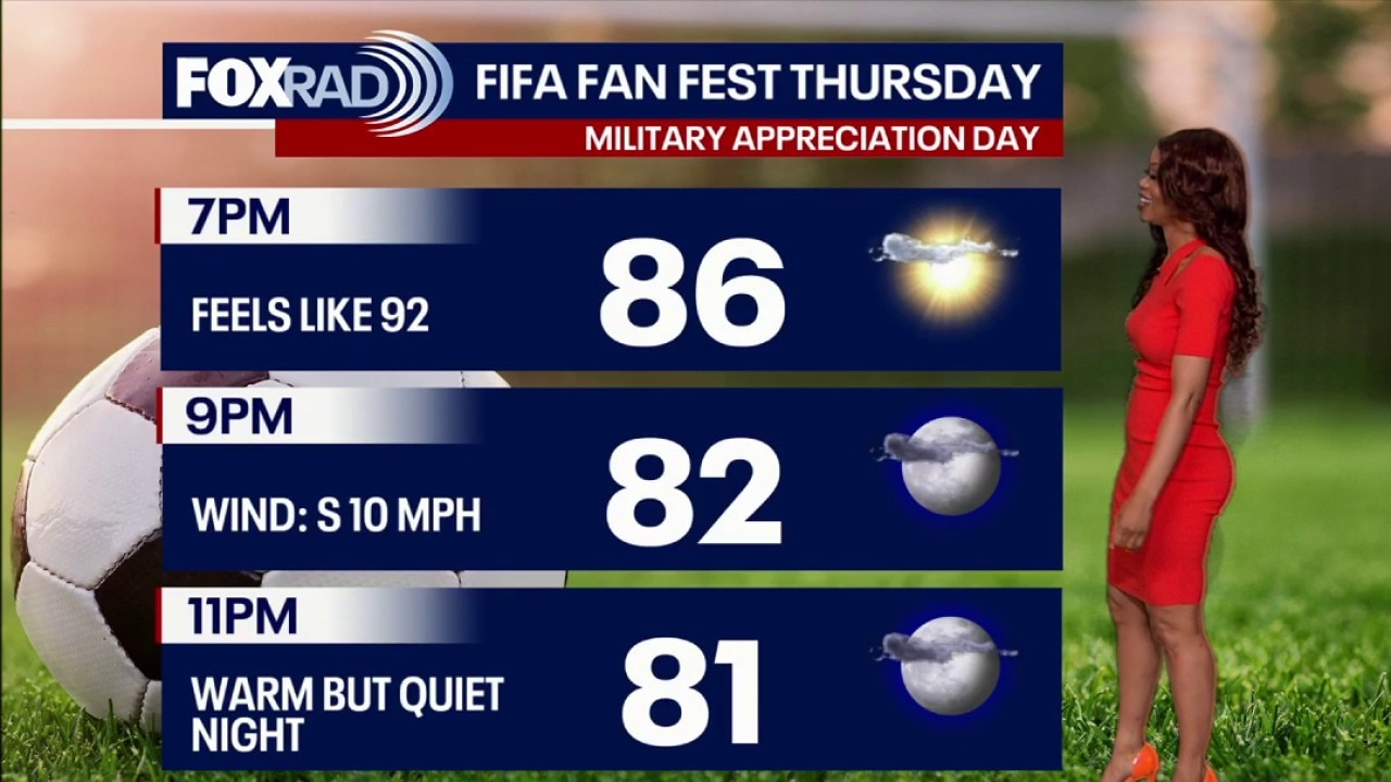
Houston weather: Warm, but quiet Thursday night
A heat dome is keeping Southeast Texas warm, but quiet.
A heat dome is keeping Southeast Texas warm, but quiet.


Heat dome to bring parts of Texas first 100-degree day of the year
A heat dome that is building across the southern U.S. this weekend will push temperatures into the triple digits for much of Texas.
A heat dome that is building across the southern U.S. this weekend will push temperatures into the triple digits for much of Texas.


Houston weather forecast for Thursday: Summer heat, Saharan dust
More typical June heat continues across Southeast Texas. Saharan dust may also bring hazy skies at times while helping keep rain chances low.
More typical June heat continues across Southeast Texas. Saharan dust may also bring hazy skies at times while helping keep rain chances low.
Houston weather forecast for Thursday: Summer heat stays on track
More typical June heat continues across Southeast Texas with highs in the 90s and heat index values above 100 each afternoon. Saharan dust remains spread across the Atlantic and Gulf, helping keep tropical activity quiet for now.
More typical June heat continues across Southeast Texas with highs in the 90s and heat index values above 100 each afternoon. Saharan dust remains spread across the Atlantic and Gulf, helping keep tropical activity quiet for now.