


Houston weather: Dec. 21 evening forecast
This week's afternoon temperatures will climb well above average, into the upper 70s and lower 80s.
This week's afternoon temperatures will climb well above average, into the upper 70s and lower 80s.

Houston weather: Christmas week forecast
If you like warm temperatures, you are going to love this week.
If you like warm temperatures, you are going to love this week.

Houston weather: Warm temps for Winter Solstice
Today is the first day of winter, but it certainly does not feel like it.
Today is the first day of winter, but it certainly does not feel like it.

Houston weather: Dec. 21 morning forecast
For the first day of winter, we look at the weather forecast and what's to come for Texas during Christmas week.
For the first day of winter, we look at the weather forecast and what's to come for Texas during Christmas week.

Houston weather: Warming up through Christmas
If you like warm temperatures, you are going to love the next week.
If you like warm temperatures, you are going to love the next week.

Houston weather: Dec. 20 evening forecast
If you like warm temperatures, you are going to love the next week.
If you like warm temperatures, you are going to love the next week.

Houston weather: Dec. 20 morning forecast
Here is a weather forecast for the coming days as the Christmas holiday nears and we take a look at how the weather will end the year.
Here is a weather forecast for the coming days as the Christmas holiday nears and we take a look at how the weather will end the year.

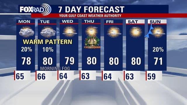
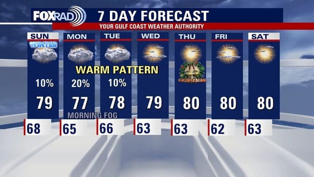
Houston weather: Unseasonably warm pattern returning
This weekend and through Christmas week, afternoon temperatures climb well above average. There's also a noticeable increase in humidity and high temperatures close to records for several days leading into Christmas. Rain chances are mainly limited to Sunday and Monday with a few light showers possible. We'll also watch out for a daily round of fog. Rain chances Tuesday drops to 10%.
This weekend and through Christmas week, afternoon temperatures climb well above average. There's also a noticeable increase in humidity and high temperatures close to records for several days leading into Christmas. Rain chances are mainly limited to Sunday and Monday with a few light showers possible. We'll also watch out for a daily round of fog. Rain chances Tuesday drops to 10%.

Houston weather: One more cool night Friday
This weekend and through Christmas week, afternoon temperatures climb well above average.
This weekend and through Christmas week, afternoon temperatures climb well above average.


Houston weather: Unseasonably warm pattern to return this weekend
Expect a big warm-up coming to the Houston area on Saturday following a cool night on Friday.
Expect a big warm-up coming to the Houston area on Saturday following a cool night on Friday.

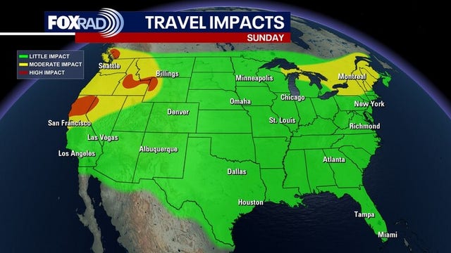
Forecasting with Friends: Holiday Travel Forecast
Traveling for the holidays? We have a look at the forecast and potential travel impacts.
Traveling for the holidays? We have a look at the forecast and potential travel impacts.

Houston weather: Chilly Friday morning in the 40s, warm weekend ahead
Friday is starting off with cool and crisp air with temperatures in the 40s. As we move into the afternoon, we'll see some more sunshine.
Friday is starting off with cool and crisp air with temperatures in the 40s. As we move into the afternoon, we'll see some more sunshine.

Houston weather: Chilly Friday morning ahead of sunny afternoon
Friday morning is kicking off with cool and crisp air with temperatures in the 40s. As we move into the afternoon, we'll see some more sunshine with highs increasing to the mid-60s.
Friday morning is kicking off with cool and crisp air with temperatures in the 40s. As we move into the afternoon, we'll see some more sunshine with highs increasing to the mid-60s.

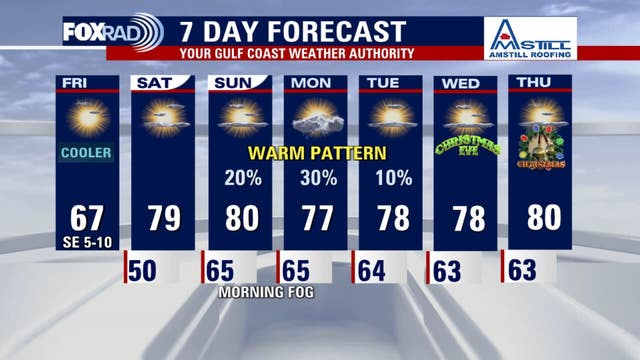
Houston weather: Cooler Friday following cold front
Following the brief cooldown on Friday, temperatures will soar to near 80° both Saturday and Sunday afternoon. Look for plenty of sunshine Saturday and more clouds Sunday along with the chance for a few light rain showers. The weather still looks pretty nice though for Texans tailgating Sunday.
Following the brief cooldown on Friday, temperatures will soar to near 80° both Saturday and Sunday afternoon. Look for plenty of sunshine Saturday and more clouds Sunday along with the chance for a few light rain showers. The weather still looks pretty nice though for Texans tailgating Sunday.

Houston weather: Dec. 18 evening forecast
Following the brief cooldown on Friday, temperatures will soar to near 80° both Saturday and Sunday afternoon.
Following the brief cooldown on Friday, temperatures will soar to near 80° both Saturday and Sunday afternoon.


Houston weather: Cold front to bring a chill to the area Thursday night, Friday
A cold front will be moving through the Houston area and will bring a chill for Thursday night.
A cold front will be moving through the Houston area and will bring a chill for Thursday night.

Forecasting with Friends: Christmas Travel Season
We're talking all things weather, including a look at the Christmas travel season.
We're talking all things weather, including a look at the Christmas travel season.

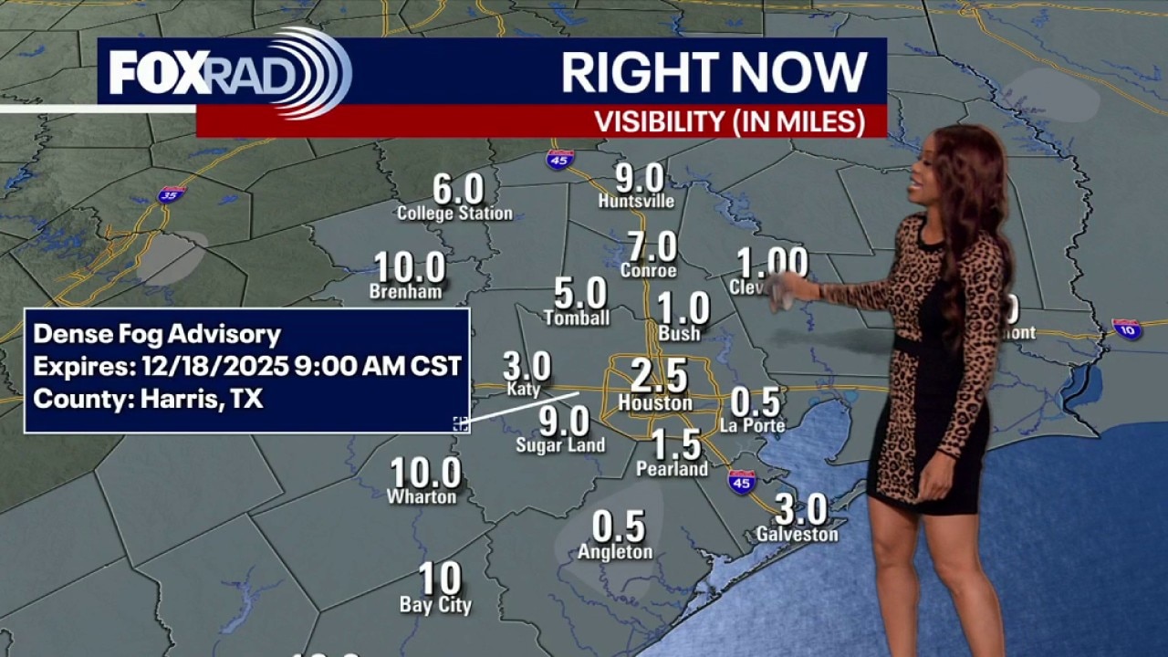
Houston weather: Foggy Thursday morning in the 60s
Houston weather: Foggy Thursday morning in the 60s
Houston weather: Foggy Thursday morning in the 60s
Houston weather: Foggy night Wednesday, ahead of warm day on Thursday
Aside from Wednesday's rain, the overall pattern stays warm with only slight chances for drizzle. A weak front slips through late Thursday into Friday, briefly lowering temperatures and humidity. Friday morning will feel noticeably cooler, but the chill does not last long and no significant cold air is expected.
Aside from Wednesday's rain, the overall pattern stays warm with only slight chances for drizzle. A weak front slips through late Thursday into Friday, briefly lowering temperatures and humidity. Friday morning will feel noticeably cooler, but the chill does not last long and no significant cold air is expected.