


Arctic Blast: Protecting home during deep freeze
With the incoming arctic cold front, it's important to think about how to protect your home. FOX 26 Meteorologist Allison Gargaro spoke with a plumber about pipe protection.


Arctic Blast: Preparing for plunge in temperatures
Brutally cold temperatures are headed to Houston in a few days but we have some insight to help you get prepared for the arctic blast. FOX 26's Jade Flury has more details for you to use.


Arctic Blast: Warming centers open at Cleveland ISD schools
Cleveland ISD announced they will be opening two warming centers for enrolled students and their families.


Texas Arctic Blast 2024: Winterizing your home for cold weather
Texas is expecting a frigid cold front to bring freezing temperatures into the area next week and you want to make sure your home is prepared.


Latest Texas Arctic Blast Timeline
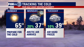
Spring-like weather is expected today. Highs in the 70s with an increase in winds. A front moves through overnight and into Friday morning bringing the chance for storms. Once the front pushes east, you can expect very windy conditions with highs in the upper 50s. Wake-up temperatures on Saturday morning will be near freezing. The weekend will be pleasant, dry and mild. Big weather changes are on the way early next week. Arctic air will make its way into Texas. Highs will be in the 30s Monday and Tuesday, but the coldest temps will be felt Tuesday morning. Some locations will be in the teens and 20s. Prepare your house and property this weekend and depend on FOX 26.


Fox 26 Houston Weather Forecast
We have so many changes on the way in the forecast. It?s hard to keep track of, but here we go with the timeline of what to expect: Today is going to feel like spring, with highs rising into the middle 70s with a few drizzles and breezy south winds. Watch for some overnight storms between around 2 AM and 5 AM early Friday, to be followed by blustery conditions on Friday. The weekend looks nice and clear, but watch out for some freezing temperatures early Saturday. The action arrives Sunday night into the MLK Day holiday with blustery north winds and temperatures stuck in the 30s all day long. The coldest air should arrive by Tuesday morning as temperatures could fall to the low 20s. As far as wintry precipitation, there is a slight chance for cold rain, light, sleet, or ice pellets, and a very slight chance for light snow flurries on Monday.


Houston weather: Texas arctic blast timeline of arrival
When will the Texas arctic blast arrive in Houston? Here's a timeline of the cold weather.


FOX 26 Houston Weather Forecast
We have so many changes on the way in the forecast. It?s hard to keep track of, but here we go with the timeline of what to expect: today is going to feel like spring with high temperatures rising into the middle 70s a few drizzles and breezy south winds. Watch for some overnight storms between around 2 AM and 5 AM early Friday to be followed by blustery conditions on Friday. for the weekend it looks nice and clear, but watch out for some freezing temperatures early Saturday. The action arrives Sunday night into the MLK day holiday with blustery north winds and temperatures stuck in the 30s all day long. The coldest air should arrive by Tuesday morning as temperatures could fall end of the low 20s. As far as wintry precipitation, there is a slight chance for cold rain, light, sleet, or ice pellets, and a very slight chance for light snow flurries.


Houston weather: Warm temps before arctic express rolls in next week
Get ready for some big weather changes over the next week as a major arctic blast pushes in by this weekend! Before we get to the super cold air on Monday, we have one other system late Thursday and early Friday that will bring a shot for a few showers and storms between 1-6 AM Friday morning. There's a low risk for a brief strong to severe storm in Houston early Friday with a slightly higher risk north of Houston. We will warm into the 70s Thursday ahead of that system with a light freeze possible early Saturday behind that system. However, an arctic blast is expected on Monday with high temperatures only in the 30s and overnight lows near 20. We dip below freezing again Tuesday night before rebounding to the 40s Wednesday. There's a slim chance for a little light rain & snow early Monday but accumulation is not expected at this time. But keep checking back as we fine-tune the forecast. Also remember to download our FOX LOCAL app for your smart tv for excusive content and special weather coverage of the arctic blast!


Houston weather: Preparations underway ahead of possibly the coldest weather in more than a year
A blast of freezing winter air is expected to surge across Texas early next week.


Houston braces for Arctic Air as ERCOT's Weather Watch nears
With just 5 days until ERCOT's weather watch takes effect, Houston's Anthony Antoine urges viewers to prepare for the impending Arctic air. As the Gulf Coast Weather Authority, FOX 26 provides team coverage, starting with Matthew Seedroff reporting on how state agencies are responding


ERCOT issued a Weather Watch for cold weather
ERCOT has issued a Weather Watch to take place from Jan. 15 through 17 ahead of freezing cold temperatures across Texas.


FOX 26 Houston Weather Forecast
Get ready for some big weather changes over the next week as a major arctic blast pushes in by this weekend! Before we get to the super cold air on Monday, we have one other system late Thursday and early Friday that will bring a shot for a few showers and storms between 1 and 6 a.m. on Friday. There's a low risk for a brief strong to severe storm in Houston early Friday with a slightly higher risk north of Houston. We will warm into the 70s Thursday ahead of that system with a light freeze possible early Saturday behind that system. However, an arctic blast is expected on Monday with high temperatures only in the 30s and overnight lows near 20. We dip below freezing again Tuesday night before rebounding to the 40s Wednesday. There's a slim chance for a little light rain & snow early Monday but accumulation is not expected at this time. But keep checking back as we fine-tune the forecast. Also, remember to download our FOX LOCAL app for your smart TV for exclusive content and special weather coverage of the Arctic blast!

Houston weather: Should we expect snow or ice for next week's Arctic Blast?
FOX 26's Remeisha Shade is tracking the cold, winter weather rolling in next week for the Houston area and gives some insight on if we will get some snow.


Houston weather: Will it snow during arctic blast?
FOX 26's Remeisha Shade is tracking the cold, winter weather rolling in next week for the Houston area and gives some insight on if we will get some snow.


Polar vortex to send arctic blast deep into US later this week
Temperatures as much as 50 degrees below average are possible in several parts of the country, with wind chills as low as -50 degrees expected for some.


Arctic blast Texas: Protect pets from freeze, Texas law for dogs outside
An arctic blast is expected to impact much of Texas, including the Houston area, bringing frigid temperatures meaning you should prepare for for keeping your furry friends and pets warm.


Arctic blast Texas: Can cold weather kill your car battery? Preventing problems
A Texas arctic blast is on the way. The cold weather can wreak havoc on your car battery. Here's how to protect your battery.


ERCOT Weather Watch issued Jan. 15 to 17 ahead of cold weather
ERCOT has issued a Weather Watch to take place from Jan. 15 through 17 ahead of freezing cold temperatures across Texas.


Houston weather daily forecast: January 10
Get ready for a weather rollercoaster over the next few days as temperatures take us on a wild ride.