


FOX 26 Houston Weather Forecast
A winter weather advisory is in effect through 6 p.m. with light icing possible. Expect steady temperatures near freezing all day with wind chills in the teens. Light freezing rain or sleet in possible. A hard freeze is expected tonight with lows in the low 20s.

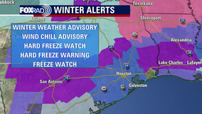
Houston weather: Latest watches, warnings, advisories ahead of arctic blast
The arctic blast is being felt in the Houston area, and several warnings, advisories and watches have been issued.


FOX 26 Houston Weather Forecast
A winter weather advisory is in effect through 6 p.m. with light icing possible. Expect steady temperatures near freezing all day with wind chills in the teens. Light freezing rain or sleet in possible. A hard freeze is expected tonight with lows in the low 20s.

Arctic blast rolling into Houston
The expected arctic blast, that we've been reporting on for several days, has finally moving into the area. Here's the latest arctic blast forecast.


Houston preparing for arctic blast
FOX 26 Reporter Natalie Hee has more on what Houstonians are doing to get ready for the approaching arctic blast.


Latest Houston arctic blast forecast
FOX 26 Meteorologist John Dawson has the very latest forecast ahead of the bone-chilling weather headed towards Houston.


Winter weather approaching Houston
The winter weather is knocking on Houston's door. Here's the latest arctic blast forecast for the Houston area.

Arctic blast threatens to impact turnout at Iowa caucuses
Monday's caucus in Iowa is expected to be the coldest in history.


FOX 26 Houston Weather Forecast
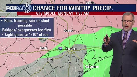
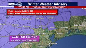
A major arctic blast is still set to arrive on Sunday and Monday. Temperatures will only climb to the 40s Sunday with overnight lows near freezing. An arctic front will roll in bringing a chance for a mix of light rain, freezing drizzle, and sleet Sunday night into Monday. The best chance will be north of I-10. Winter Weather Advisory has been issued for many areas near and north of I-10 from 6 p.m. Sunday to 6 p.m. Monday including Montgomery, Walker, San Jacinto, Polk, Washington, Grimes, N. Liberty, Colorado, Austin & Waller counties. Up to 1/10" of ice is possible in these spots and bridges and overpasses will be the first to have problems. So slow things down and be very careful if you have to get out. Along with the chance for ice, the coldest air in about 13 months is expected Monday and Tuesday with highs in the 30s. Lows Monday night and Tuesday night will be near record lows near 20 for Houston. Make sure you dress in layers, keep pets, pipes & plants protected and drive with caution. We are tracking every angle of this arctic blast and you can too by downloading the FOX Local app on your smart TV.

Texas Arctic Blast: Ice threat increasing for parts of Southeast Texas, new alerts issued
With the dangerous Arctic blast soon to be blowing into the Houston area, FOX 26 Meteorologist reports on which areas have a higher chance for ice over the next few days.


Northern US facing dangerous wintery conditions
Much of the northern U.S. faces rain, snow, and the bitter cold! FOX Weather's Max Gordon reports on the messy, dangerous winter conditions facing the states up north.


FOX 26 Houston Weather Forecast
A major arctic blast is still set to arrive Sunday and Monday. Temperatures will only climb to the 40s Sunday with overnight lows near freezing. An arctic front will roll in bringing a chance for a mix of light rain, freezing drizzle, and sleet Sunday night into Monday. Best chance will be north of I-10. Winter Weather Advisory has been issued for many areas near and north of I-10 from 6 PM Sunday to 6 PM Monday including Montgomery, Walker, San Jacinto, Polk, Washington, Grimes, N. Liberty, Colorado, Austin & Waller counties. Up to 1/10" of ice is possible in these spots and bridges and overpasses will be the first to have problems. So slow things down and be very careful if you have to get out. Along with the chance for ice, the coldest air in about 13 months is expected Monday and Tuesday with highs in the 30s. Lows Monday night and Tuesday night will be near record lows near 20 for Houston. Make sure you dress in layers, keep pets, pipes & plants protected, and drive with caution. We are tracking every angle of this arctic blast and you can too by downloading the FOX Local app on your smart TV.


Arctic Blast update, areas with chance for ice
FOX 26 Meteorologist Remeisha Shade updates us on the dangerous arctic blast and which areas now have a higher chance for ice over the next few days.


Arctic Blast Houston: Donations being accepted for homeless during cold weather
Houston Millennials is partnering with Exclusive Furniture to accept donations of coats and blankets for homeless individuals to stay warm during the cold temperatures.


Harris County Judge Lina Hidalgo provides an update on weather preparedness
Harris County Judge Lina Hidalgo provides an update on weather preparedness In response to the impending extreme cold weather event, Harris County Judge Lina Hidalgo is holding a press conference to detail the county's comprehensive preparation

Arctic blast Texas: 11 everyday household items, including old pantyhose to warm up your home
During the hard winters, consider these eco-friendly and affordable solutions to keep your home warm and inviting


Vermont State Trooper plunges into freezing waters to save 8-year-old: video
Body camera footage captures the moment the trooper arrived to the scene and dove into the icy winter pond to save the child.


FOX 26 Houston Weather Forecast
An arctic blast is on its way to Houston later this weekend and into early next week. We have wake up temperatures in the 30s this holiday weekend. A front sweeps across the state bringing the potential for freezing rain or sleet on Monday. The coldest temperatures of the season will be felt on Tuesday and Wednesday mornings. Most of the area will be in the 20s. Prepare your property this weekend. You can watch live coverage of this arctic blast all weekend long by downloading the FOX Local app on your smart tv


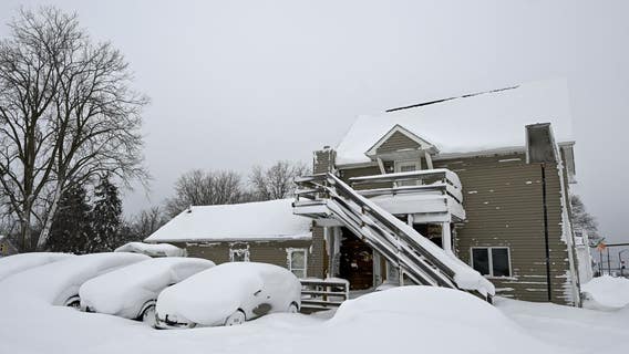
Arctic blast brings below-zero temps, blinding snow to millions across US
Every state in the country is under some sort of weather advisory this weekend as a polar vortex sends an arctic blast across much of America.


FOX 26 Houston Weather Forecast
The first shot of cold air is moving into southeast Texas tonight. The really cold air is coming later to Houston, but be ready for morning lows in the 30s for the holiday weekend. Saturday afternoon should be comfortable with less wind and mild temperatures. Sunday will be another windy day with temperatures steady and cool. There are still some questions in the forecast for Monday concerning precipitation, but right now light rain with some isolated sleet possible for our northern counties. Tuesday and Wednesday mornings are still on track to have most of the FOX 26 area in the 20. Make sure to download the FOX LOCAL app for your smart TV for exclusive content and special coverage of this artic blast.