


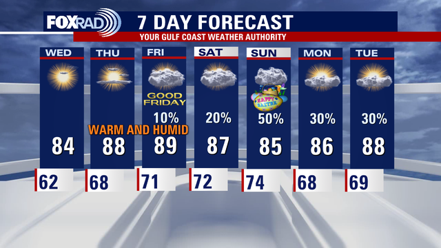
Houston weather: Muggy, humid day ahead for Friday; wet Easter Sunday possible
A south breeze has kicked in and will get stronger for Good Friday - wind gusts could exceed 30 mph on Friday along with very warm air and high humidity. Rain will remain sparse Thursday and Friday with only a few showers possible. Severe storms will be possible in West and North Texas.
A south breeze has kicked in and will get stronger for Good Friday - wind gusts could exceed 30 mph on Friday along with very warm air and high humidity. Rain will remain sparse Thursday and Friday with only a few showers possible. Severe storms will be possible in West and North Texas.

9 years since 2016 Tax Day floods | Forecasting with Friends
Chief Meteorologist Mike Iscovitz and Allison Gargaro take a look back at the 2016 Tax Day floods that hit the Houston-area.
Chief Meteorologist Mike Iscovitz and Allison Gargaro take a look back at the 2016 Tax Day floods that hit the Houston-area.


Houston weather: Breezy, very warm Thursday; possible storms Easter Sunday
A south breeze begins Thursday and will get windier for Good Friday. The afternoon will be partly cloudy and breezy with highs in the mid to upper 80s later.
A south breeze begins Thursday and will get windier for Good Friday. The afternoon will be partly cloudy and breezy with highs in the mid to upper 80s later.

Houston weather: Calm Thursday morning in the 60s
It's a mild Thursday morning in the 60s, while the afternoon will be partly cloudy and breezy. Expect temperature highs in the mid to upper 80s later in the day.
It's a mild Thursday morning in the 60s, while the afternoon will be partly cloudy and breezy. Expect temperature highs in the mid to upper 80s later in the day.

Houston weather: Muggy air, more wind possible Thursday
A south breeze will kick in for Thursday and Good Friday - we're talking 20-30 mph winds. Muggy air will also increase, but rain chances remain low with only a stray shower expected. Look for highs in the mid to upper 80s.
A south breeze will kick in for Thursday and Good Friday - we're talking 20-30 mph winds. Muggy air will also increase, but rain chances remain low with only a stray shower expected. Look for highs in the mid to upper 80s.


Houston weather: More wind, humidity before potential Easter showers
A south breeze will kick in for Thursday and Good Friday - we're talking 20-30 mph winds.
A south breeze will kick in for Thursday and Good Friday - we're talking 20-30 mph winds.

Houston weather: Easter Sunday rain chances
The computer models are not in very good agreement on the timing and intensity of rain on Easter, but the bottom line is that showers are still likely on Sunday and a few strong storms are now a concern.
The computer models are not in very good agreement on the timing and intensity of rain on Easter, but the bottom line is that showers are still likely on Sunday and a few strong storms are now a concern.

LA wildfire recovery, emergency "streamlight" test, and more | Forecasting With Friends
Join the FOX 26 Weather Team as we talk all things weather on our newest show!
Join the FOX 26 Weather Team as we talk all things weather on our newest show!


Increased tornado warnings may face delays amid tech setbacks
According to documents obtained by congressional members, the Trump administration has proposed reducing NOAA’s budget significantly below its current level of more than $6 billion.
According to documents obtained by congressional members, the Trump administration has proposed reducing NOAA’s budget significantly below its current level of more than $6 billion.

Houston weather: Calm Wednesday morning in the 60s
It's a pleasant Wednesday morning, then the day becomes breezy and warm this afternoon with highs in the mid 80s. A south breeze will kick in for Thursday and Good Friday - we're talking 20-30 mph winds.
It's a pleasant Wednesday morning, then the day becomes breezy and warm this afternoon with highs in the mid 80s. A south breeze will kick in for Thursday and Good Friday - we're talking 20-30 mph winds.

Houston weather: Another warm day ahead on Wednesday
A south breeze will kick late Wednesday and will stay in place through Easter - that means humidity levels will increase. Expect very warm and humid air for Good Friday with a stray shower possible. Saturday brings muggy air and a few drizzles. The timing of rain for Easter Sunday is still uncertain, but scattered showers are expected along with a dewy, muggy morning and highs in the mid 80s.
A south breeze will kick late Wednesday and will stay in place through Easter - that means humidity levels will increase. Expect very warm and humid air for Good Friday with a stray shower possible. Saturday brings muggy air and a few drizzles. The timing of rain for Easter Sunday is still uncertain, but scattered showers are expected along with a dewy, muggy morning and highs in the mid 80s.

Houston weather: Pleasant, quiet weather on the way for Wednesday
A south breeze will kick late Wednesday and will stay in place through Easter - that means humidity levels will increase. Expect very warm and humid air for Good Friday with a stray shower possible.
A south breeze will kick late Wednesday and will stay in place through Easter - that means humidity levels will increase. Expect very warm and humid air for Good Friday with a stray shower possible.

Houston weather: Pleasant, quiet Wednesday on the way
A south breeze will kick late Wednesday and will stay in place through Easter - that means humidity levels will increase. Expect very warm and humid air for Good Friday with a stray shower possible. Saturday brings muggy air and a few drizzles. The timing of rain for Easter Sunday is still uncertain, but scattered showers are expected along with a dewy, muggy morning and highs in the mid 80s.
A south breeze will kick late Wednesday and will stay in place through Easter - that means humidity levels will increase. Expect very warm and humid air for Good Friday with a stray shower possible. Saturday brings muggy air and a few drizzles. The timing of rain for Easter Sunday is still uncertain, but scattered showers are expected along with a dewy, muggy morning and highs in the mid 80s.

Atlantic hurricane season forecast | Forecasting with Friends
Hurricane season is rapidly approaching. We're taking a look at the forecast and more in this episode of Forecasting with Friends.
Hurricane season is rapidly approaching. We're taking a look at the forecast and more in this episode of Forecasting with Friends.
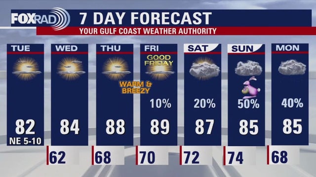

Houston weather: Slightly cooler Tuesday, but get ready for humidity
A weak cold front should bring slightly lower humidity and shave about 3-5 degrees off afternoon temps today. But humidity levels will rise again soon.
A weak cold front should bring slightly lower humidity and shave about 3-5 degrees off afternoon temps today. But humidity levels will rise again soon.

Houston weather: Cooler Tuesday morning in the 60s
Temperatures are slightly cooler Tuesday morning in the 60s. Keep a look out for some patchy areas of fog. The afternoon is expected to become mostly sunny with highs in the low 80s.
Temperatures are slightly cooler Tuesday morning in the 60s. Keep a look out for some patchy areas of fog. The afternoon is expected to become mostly sunny with highs in the low 80s.

Houston weather: Warm weather days ahead for Houston
It was another warm, muggy and windy day in Houston, with temperatures soaring to the 80s. A weak cold front will pass through early tomorrow morning and will bring a very slight drop in humidity and temperatures, but really just a few degrees at best. Otherwise, rain chances stay very low - there could be a short-lived shower along the front early Wednesday, but we probably won't see much until this Easter weekend.
It was another warm, muggy and windy day in Houston, with temperatures soaring to the 80s. A weak cold front will pass through early tomorrow morning and will bring a very slight drop in humidity and temperatures, but really just a few degrees at best. Otherwise, rain chances stay very low - there could be a short-lived shower along the front early Wednesday, but we probably won't see much until this Easter weekend.

Blue Origin Launch - Monday's With Mike
Join FOX 26 Chief Meteorologist Mike Iscovitz as he talks about the history NS-31 mission launch from near Van Horn, Texas on Monday morning.
Join FOX 26 Chief Meteorologist Mike Iscovitz as he talks about the history NS-31 mission launch from near Van Horn, Texas on Monday morning.

Blue Origin launch, National Tropical Weather Conference, and more! - Forecasting With Friends
Join FOX 26 Chief Meteorologist Mike Iscovitz as he has the latest weather news including the Blue Origin Launch. Meterologist John Dawson also joins the show from the National Tropical Weather Conference.
Join FOX 26 Chief Meteorologist Mike Iscovitz as he has the latest weather news including the Blue Origin Launch. Meterologist John Dawson also joins the show from the National Tropical Weather Conference.

Houston weather: Warm weather days ahead this week
It was another warm, muggy and windy day in Houston, with temperatures soaring to the 80s. A weak cold front will pass through early tomorrow morning and will bring a very slight drop in humidity and temperatures, but really just a few degrees at best. Otherwise, rain chances stay very low - there could be a short-lived shower along the front early Wednesday, but we probably won't see much until this Easter weekend.
It was another warm, muggy and windy day in Houston, with temperatures soaring to the 80s. A weak cold front will pass through early tomorrow morning and will bring a very slight drop in humidity and temperatures, but really just a few degrees at best. Otherwise, rain chances stay very low - there could be a short-lived shower along the front early Wednesday, but we probably won't see much until this Easter weekend.