


Victorinox Rescue Tool | JD's Hurricane Gear Test
We are talking tools in this segment of JD's Hurricane Gear Test and he's featuring the Victorinox Rescue Tool.
We are talking tools in this segment of JD's Hurricane Gear Test and he's featuring the Victorinox Rescue Tool.


Share your memories, photos from Hurricane Katrina | TELL 26 poll
In honor of 20 years since Hurricane Katrina, share your photos, videos and memories pf Hurricane Katrina.
In honor of 20 years since Hurricane Katrina, share your photos, videos and memories pf Hurricane Katrina.

Tropical Weather Update: August 24, 2025
Tropical Storm Fernand is slowly strengthening and should move across the open waters of the subtropical central Atlantic well east and northeast of Bermuda. Data from Air Force reconnaissance aircraft indicate that the tropical wave east of the Windward Islands (Invest 99L) does not have a closed low-level circulation. The system is expected to reach the central Caribbean Sea on Tuesday, where conditions are forecast to become less favorable for additional development.
Tropical Storm Fernand is slowly strengthening and should move across the open waters of the subtropical central Atlantic well east and northeast of Bermuda. Data from Air Force reconnaissance aircraft indicate that the tropical wave east of the Windward Islands (Invest 99L) does not have a closed low-level circulation. The system is expected to reach the central Caribbean Sea on Tuesday, where conditions are forecast to become less favorable for additional development.

Houston weather: August 23 overnight forecast
The FOX 26 Weekend Team provides the latest local, regional, and national news events of the day.
The FOX 26 Weekend Team provides the latest local, regional, and national news events of the day.

Tropical Weather Update: Tropical Storm Fernand forms in the Atlantic
Tropical Storm Fernand has formed in the Atlantic. Fernand should follow a path similar to Hurricane Erin, avoiding a direct landfall to the US coast. Conditions are not as favorable as they were for Erin, so Fernand is expected to be an overall smaller system.
Tropical Storm Fernand has formed in the Atlantic. Fernand should follow a path similar to Hurricane Erin, avoiding a direct landfall to the US coast. Conditions are not as favorable as they were for Erin, so Fernand is expected to be an overall smaller system.

Tropical Weather Update: Hurricane Erin drops to "post-tropical"
Hurricane Erin has officially lost tropical characteristics and become "post-tropical" as it moves away from the U.S. East Coast and becomes a cold weather wind storm in the north Atlantic. Elsewhere, a tropical wave will likely become Fernand and will follow a similar path to Erin - avoiding any U.S. landfall. It's likely to be a much smaller system. Behind that, another wave should be slow to develop as it moves toward the Caribbean. Models are not showing it doing much just yet, but it's one to watch longer term.
Hurricane Erin has officially lost tropical characteristics and become "post-tropical" as it moves away from the U.S. East Coast and becomes a cold weather wind storm in the north Atlantic. Elsewhere, a tropical wave will likely become Fernand and will follow a similar path to Erin - avoiding any U.S. landfall. It's likely to be a much smaller system. Behind that, another wave should be slow to develop as it moves toward the Caribbean. Models are not showing it doing much just yet, but it's one to watch longer term.
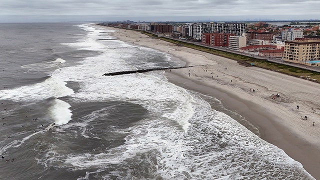

Hurricane Erin spins away but rip currents, rough seas to last through weekend
Hurricane Erin’s core missed the U.S., but the cyclone led to flooded roadways and eroded dunes. Coastal flooding was reported in North Carolina, Virginia, Delaware, New Jersey, and New York.
Hurricane Erin’s core missed the U.S., but the cyclone led to flooded roadways and eroded dunes. Coastal flooding was reported in North Carolina, Virginia, Delaware, New Jersey, and New York.

Tropical Update: Hurricane Erin makes indirect impact in U.S. East Coast; other Atlantic waves
As of Aug. 21, Hurricane Erin has dropped to Category 2 with maximum winds close to 100 mph. It is well offshore of North Carolina and Virginia, but coastal flooding and a high rip currents risk will continue along the Carolina coast and Mid-Atlantic. We're watching three other tropical waves in the Atlantic.
As of Aug. 21, Hurricane Erin has dropped to Category 2 with maximum winds close to 100 mph. It is well offshore of North Carolina and Virginia, but coastal flooding and a high rip currents risk will continue along the Carolina coast and Mid-Atlantic. We're watching three other tropical waves in the Atlantic.


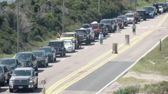
Hurricane Erin slams North Carolina, Virginia coasts with strong winds, powerful waves, dangerous rip currents
Thousands of people were evacuated off parts of North Carolina's Outer Banks amid the threat of a storm surge. Meanwhile, beaches remained off limits along the East Coast as dangerous waves and rip currents slammed shorelines.
Thousands of people were evacuated off parts of North Carolina's Outer Banks amid the threat of a storm surge. Meanwhile, beaches remained off limits along the East Coast as dangerous waves and rip currents slammed shorelines.

Tropical Update: Hurricane Erin to make indirect impact to east U.S.
Hurricane Erin has made its turn to the north in the Atlantic as it passes east of Florida. The latest models have Erin making a curve to the northeast, moving away from the eastern coast of the U.S. Indirect impacts of large swells, coastal flooding and dangerous rip currents are likely up and down the eastern seaboard, especially in coastal North Carolina. We are also watching two tropical waves in the Eastern Atlantic which now have a 60% and 40% chance for development over the next seven days.
Hurricane Erin has made its turn to the north in the Atlantic as it passes east of Florida. The latest models have Erin making a curve to the northeast, moving away from the eastern coast of the U.S. Indirect impacts of large swells, coastal flooding and dangerous rip currents are likely up and down the eastern seaboard, especially in coastal North Carolina. We are also watching two tropical waves in the Eastern Atlantic which now have a 60% and 40% chance for development over the next seven days.


Hurricane Erin tracker: Updates, path, radar, impacts
Hurricane Erin maintains its Category 2 status as it makes its turn to the north in the Atlantic as is passes Florida's eastern coast. Several watches and warning have been places in effect for areas on the East Coast.
Hurricane Erin maintains its Category 2 status as it makes its turn to the north in the Atlantic as is passes Florida's eastern coast. Several watches and warning have been places in effect for areas on the East Coast.


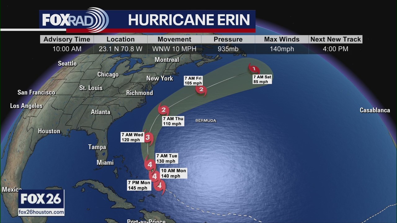
Hurricane Erin making closest approach to US with massive waves, dangerous rip currents
Hurricane Erin remains a powerful Category 2 hurricane with winds of 110 mph. However, the National Hurricane Center said additional strengthening is likely over the next day or so, and Erin could become a major hurricane (Category 3 or higher) by Wednesday night.
Hurricane Erin remains a powerful Category 2 hurricane with winds of 110 mph. However, the National Hurricane Center said additional strengthening is likely over the next day or so, and Erin could become a major hurricane (Category 3 or higher) by Wednesday night.

Tropical Weather Update - Watching Erin as well as other possible systems in the Atlantic
Hurricane Erin continues to churn in the Atlantic as it passes east of the Bahamas. The latest models have Erin curving away from the eastern coast of the U.S. this week. Indirect impacts of large swells, coastal flooding and dangerous rip currents are likely up and down the eastern seaboard, especially in coastal North Carolina. Tropical Storm and Storm Surge warnings are now in place for the Outer Banks of North Carolina. Erin will make its closest approach to the U.S. late Wednesday and Thursday around the north Carolina coast. The system is far away from Texas and will have no effect on our area. We are also watching two tropical waves in the Eastern Atlantic which now have a 60% and 30% chance for development over the next seven days. Stay up-to-date with the latest tropical updates on the free FOX Local app.
Hurricane Erin continues to churn in the Atlantic as it passes east of the Bahamas. The latest models have Erin curving away from the eastern coast of the U.S. this week. Indirect impacts of large swells, coastal flooding and dangerous rip currents are likely up and down the eastern seaboard, especially in coastal North Carolina. Tropical Storm and Storm Surge warnings are now in place for the Outer Banks of North Carolina. Erin will make its closest approach to the U.S. late Wednesday and Thursday around the north Carolina coast. The system is far away from Texas and will have no effect on our area. We are also watching two tropical waves in the Eastern Atlantic which now have a 60% and 30% chance for development over the next seven days. Stay up-to-date with the latest tropical updates on the free FOX Local app.


Hurricane Erin tracker: Updates, path, impacts, radar
Hurricane Erin continues to churn in the Atlantic as it passes east of the Bahamas. Here are the latest updates on its path, where it is, radar, impacts and strength.
Hurricane Erin continues to churn in the Atlantic as it passes east of the Bahamas. Here are the latest updates on its path, where it is, radar, impacts and strength.

VIDEOS: Hurricane Erin moves across the Atlantic
Videos show rain and winds from Hurricane Erin as it moves across the Atlantic Ocean.
Videos show rain and winds from Hurricane Erin as it moves across the Atlantic Ocean.

Hurricane Erin moves closer to US
Hurricane Erin rapidly intensified last week, going from a Category 1 hurricane to a Category 5 hurricane with winds of 160 mph in a matter of hours.
Hurricane Erin rapidly intensified last week, going from a Category 1 hurricane to a Category 5 hurricane with winds of 160 mph in a matter of hours.


Hurricane Erin tracker: Path, impacts, forecast, radar
Erin continues to churn across the Atlantic as a major, Category 4 hurricane on Monday. Here's the latest track, path and impacts, plus interactive radar.
Erin continues to churn across the Atlantic as a major, Category 4 hurricane on Monday. Here's the latest track, path and impacts, plus interactive radar.
Hurricane Erin update Monday: Path, impacts
FOX 26 Meteorologist Allison Gargaro has the latest on Hurricane Erin, which is churning across the Atlantic as a Category 4 storm. She has more on where Erin is going and who will be impacted.
FOX 26 Meteorologist Allison Gargaro has the latest on Hurricane Erin, which is churning across the Atlantic as a Category 4 storm. She has more on where Erin is going and who will be impacted.

Tropical Weather: Hurricane Erin, other developments - Aug. 17 update
Hurricane Erin continues to churn in the Atlantic as it passes north of Puerto Rico, Haiti and the Dominican Republic. Tropical storm warnings are now in effect for the Turks and Caicos Islands and for the Southeast Bahamas. There are two other areas in the Atlantic with the chance for further development. We are also watching a tropical wave near the west coast of Africa over the next several days. Right now, the national hurricane center is giving it a low 30% chance for development.
Hurricane Erin continues to churn in the Atlantic as it passes north of Puerto Rico, Haiti and the Dominican Republic. Tropical storm warnings are now in effect for the Turks and Caicos Islands and for the Southeast Bahamas. There are two other areas in the Atlantic with the chance for further development. We are also watching a tropical wave near the west coast of Africa over the next several days. Right now, the national hurricane center is giving it a low 30% chance for development.

Tropical Weather: Hurricane Erin drops to Cat 3; other Atlantic developments
Hurricane Erin continues to churn in the Atlantic, bringing heavy rain and strong winds to Puerto Rico and the Dominican Republic. FOX 26 Meteorologist Allison Gargaro gives a morning update for Aug 17 on Erin and two other developments in the Atlantic.
Hurricane Erin continues to churn in the Atlantic, bringing heavy rain and strong winds to Puerto Rico and the Dominican Republic. FOX 26 Meteorologist Allison Gargaro gives a morning update for Aug 17 on Erin and two other developments in the Atlantic.