


Saturday weather forecast with Meteorologist Lena Maria Arango
Days like today are going to be harder and harder to come by in southeast Texas, so enjoy it in all of it's glory! Tomorrow afternoon through most of the week features on and off showers and storms as a series of disturbances move their way across the area. While it won't be raining all the time, the pattern overall looks more wet than dry. Our next beautiful day to look forward to at this point looks to be Friday!
Days like today are going to be harder and harder to come by in southeast Texas, so enjoy it in all of it's glory! Tomorrow afternoon through most of the week features on and off showers and storms as a series of disturbances move their way across the area. While it won't be raining all the time, the pattern overall looks more wet than dry. Our next beautiful day to look forward to at this point looks to be Friday!

Houston-area weather forecast: Nice Saturday ahead, Sunday may see some showers
Look for bright sunshine Saturday with highs in the upper 70s. Sunday will bring another round of rain for some as a coastal low develops to our SW. Best chance for heavy rain should stay SW of Houston. Next week looks a bit unsettled for the beginning and middle of the week with the best chance for rain and storms coming on Tuesday.
Look for bright sunshine Saturday with highs in the upper 70s. Sunday will bring another round of rain for some as a coastal low develops to our SW. Best chance for heavy rain should stay SW of Houston. Next week looks a bit unsettled for the beginning and middle of the week with the best chance for rain and storms coming on Tuesday.

Houston weather: Partial sunshine Friday evening with warm temps
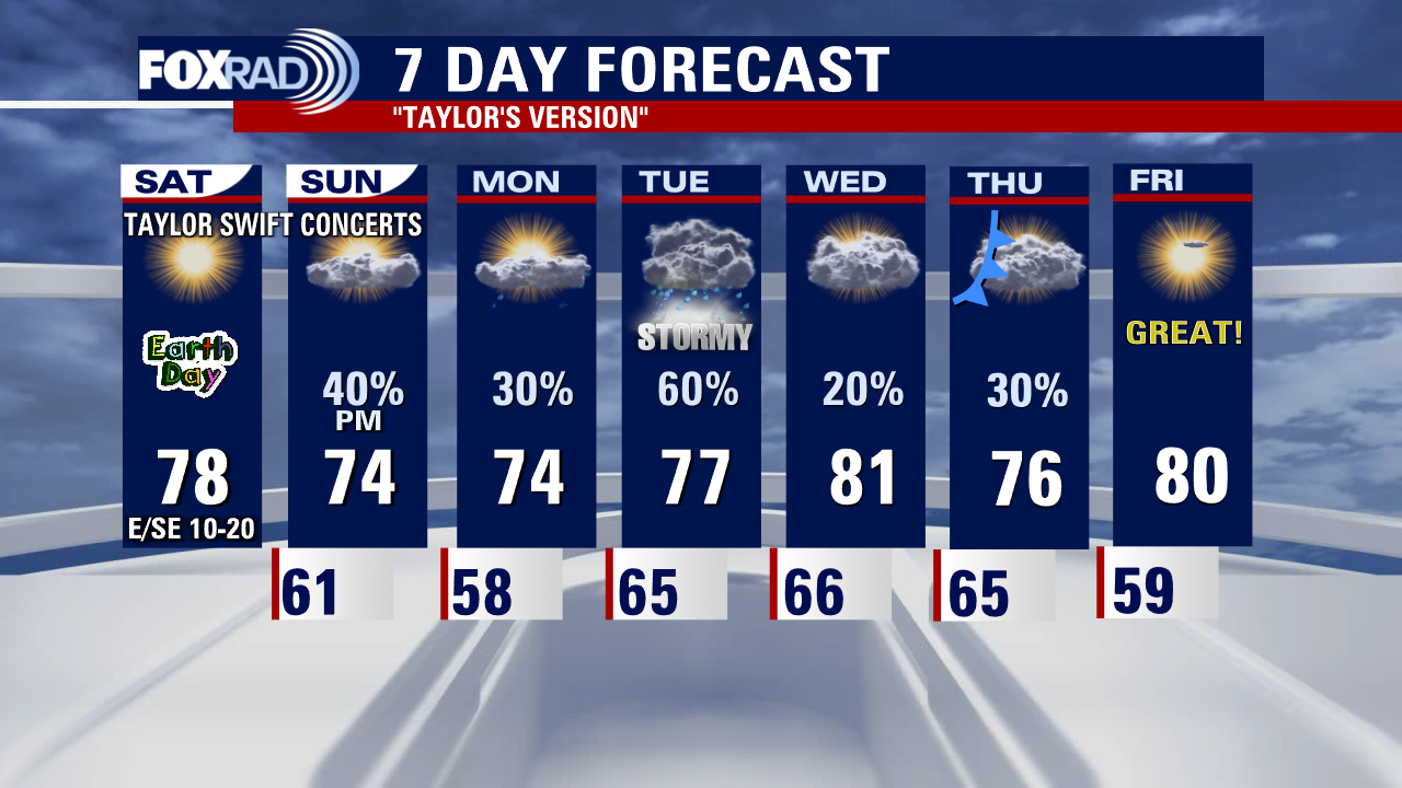
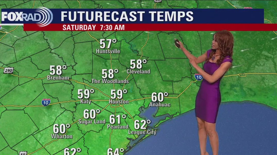
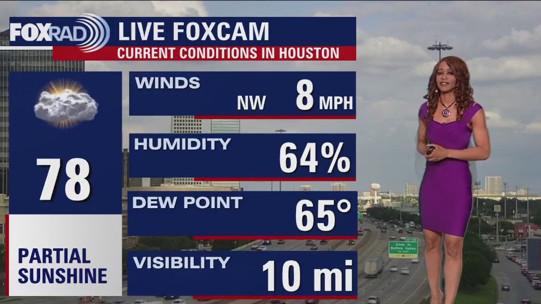
he rounds of strong to severe storms last night and this morning have pushed out leaving us with mainly quiet weather. Other than a stray shower east early this evening, we should be quiet tonight and cooler with overnight lows in the 50s behind a cold front. Look for bright sunshine Saturday with highs in the upper 70s. Sunday will bring another round of rain for some as a coastal low develops to our SW. Best chance for heavy rain should stay SW of Houston. Next week looks a bit unsettled for the beginning and middle of the week with the best chance for rain and storms coming on Tuesday. If you are heading out to the Taylor swift concert this evening, weather should be mild and mainly dry with no severe weather expected. Enjoy your night!
he rounds of strong to severe storms last night and this morning have pushed out leaving us with mainly quiet weather. Other than a stray shower east early this evening, we should be quiet tonight and cooler with overnight lows in the 50s behind a cold front. Look for bright sunshine Saturday with highs in the upper 70s. Sunday will bring another round of rain for some as a coastal low develops to our SW. Best chance for heavy rain should stay SW of Houston. Next week looks a bit unsettled for the beginning and middle of the week with the best chance for rain and storms coming on Tuesday. If you are heading out to the Taylor swift concert this evening, weather should be mild and mainly dry with no severe weather expected. Enjoy your night!

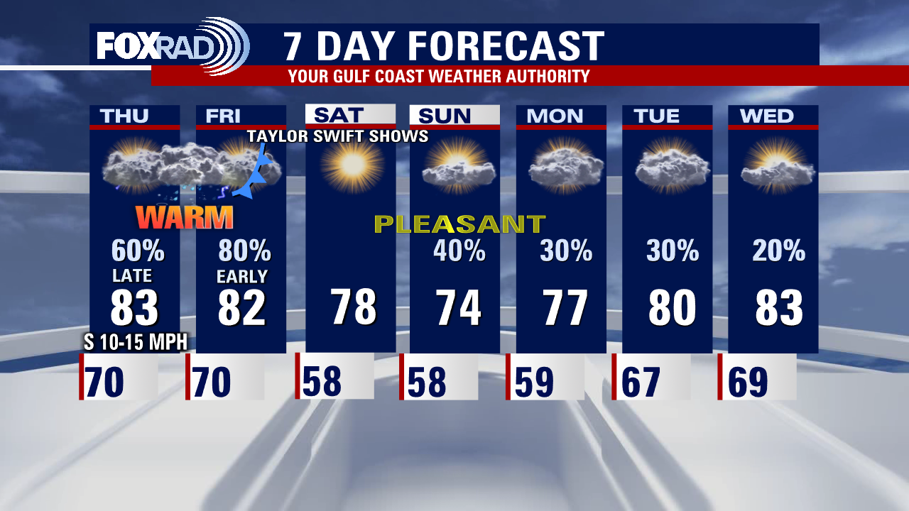
Slim chance for isolated shower, warm temps Friday afternoon
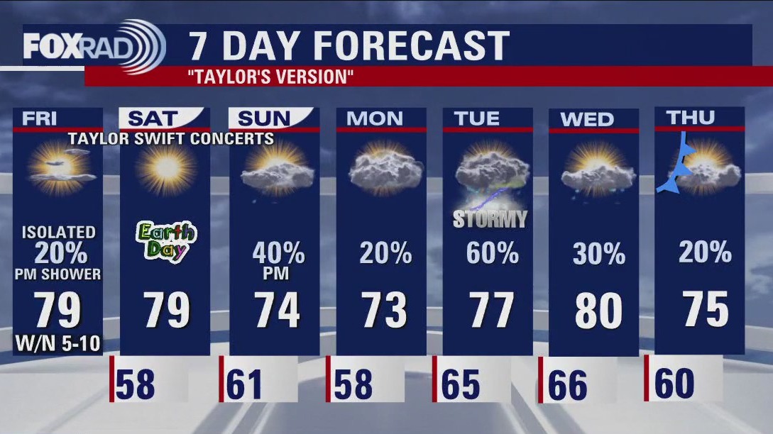
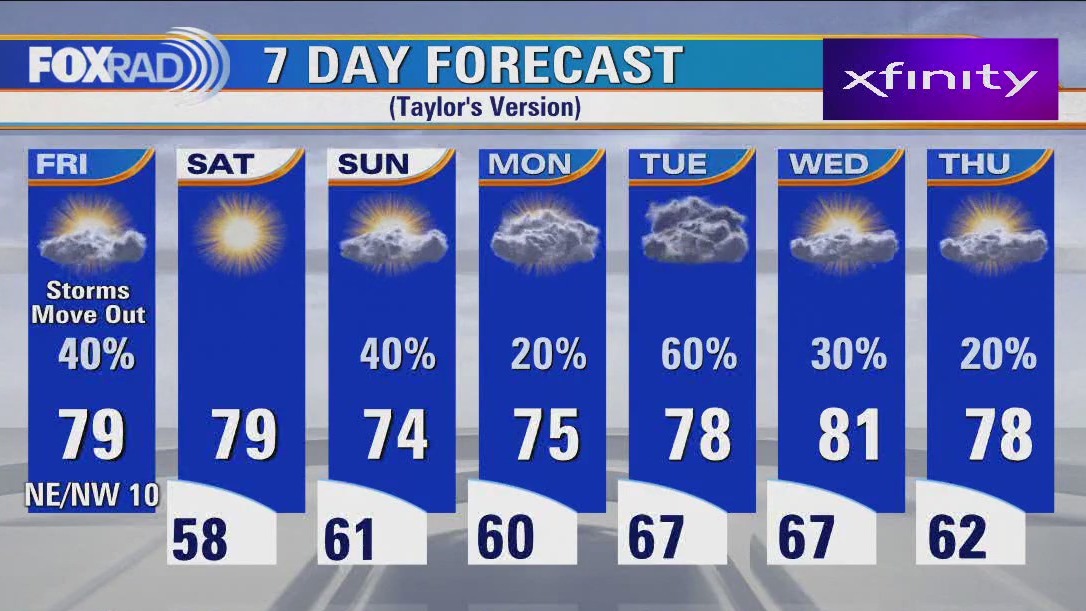
The remainder of Friday features only a slim chance at a stray shower or storm as the cold front ushers in a wind shift. That will lead to bright blue skies and abundant sunshine on Saturday paired with low humidity. Is it a weather Love Story? We wish we could say yes to those conditions all weekend long. While Sunday will start off mostly dry, some showers pushing in from the south and west later in the day may be your Anti-hero as you're heading to NRG for the last of the 3 concert Taylor Swift series!
The remainder of Friday features only a slim chance at a stray shower or storm as the cold front ushers in a wind shift. That will lead to bright blue skies and abundant sunshine on Saturday paired with low humidity. Is it a weather Love Story? We wish we could say yes to those conditions all weekend long. While Sunday will start off mostly dry, some showers pushing in from the south and west later in the day may be your Anti-hero as you're heading to NRG for the last of the 3 concert Taylor Swift series!


Rare desert waterfalls still flowing a month after record snowfall awakened them
It's only the fourth time in 15 years the water has been strong enough to create the falls.
It's only the fourth time in 15 years the water has been strong enough to create the falls.

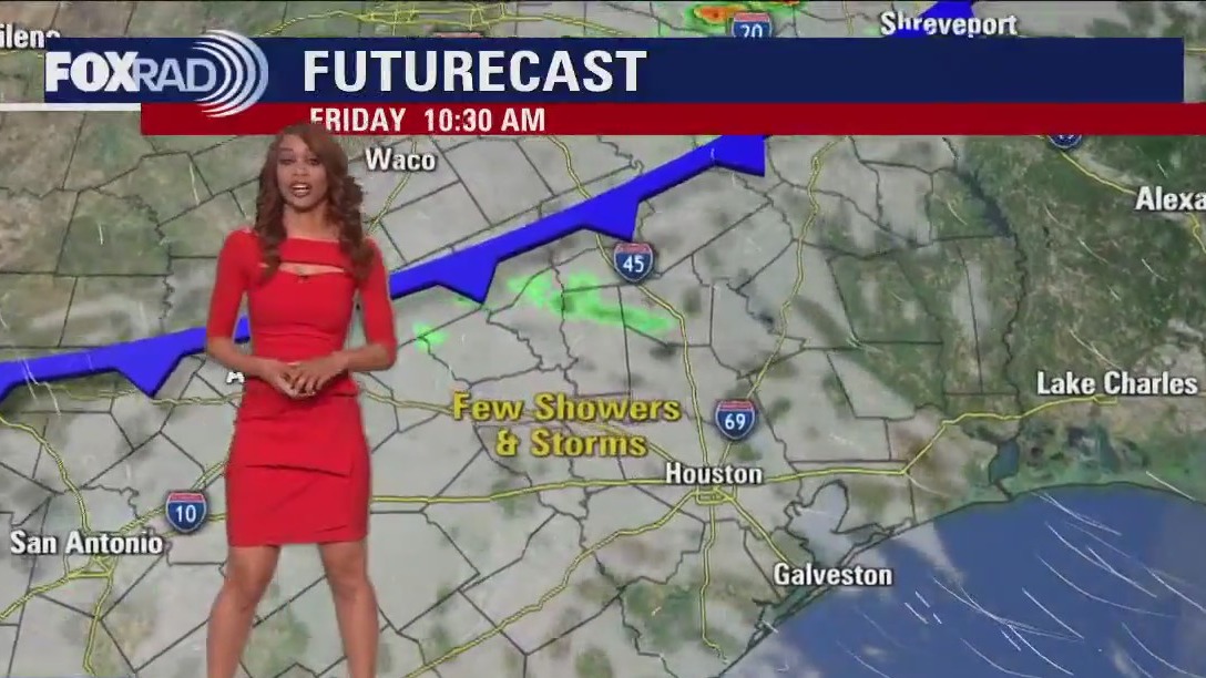
Houston weather: Friday morning storms, then better with scattered showers
After some whopper early morning storms, the rest of your Friday looks better, though not perfect. A front will move in for the early afternoon, so a few scattered showers are possible. Weather looks pretty nice for the Taylor Swift show this evening. Saturday is looking great, but clouds and showers could return on Sunday. Next week is looking "unsettled".
After some whopper early morning storms, the rest of your Friday looks better, though not perfect. A front will move in for the early afternoon, so a few scattered showers are possible. Weather looks pretty nice for the Taylor Swift show this evening. Saturday is looking great, but clouds and showers could return on Sunday. Next week is looking "unsettled".

Houston-area weather forecast: Strong storms early Friday morning, clearing out for the weekend
Cold front will move through during Friday afternoon where one or two storms could redevelop. But the atmosphere will be worked over and the chance is low. Behind the front Friday evening, we will be drying out and clearing out meaning great weather for everyone flocking to NRG to catch Taylor Swift!
Cold front will move through during Friday afternoon where one or two storms could redevelop. But the atmosphere will be worked over and the chance is low. Behind the front Friday evening, we will be drying out and clearing out meaning great weather for everyone flocking to NRG to catch Taylor Swift!
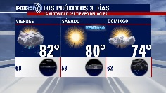

El Tiempo 20 de Abril de 2023
#FOX26 Meteor?loga Lena Maria Arango tiene su pron?stico para el fin de semana.
#FOX26 Meteor?loga Lena Maria Arango tiene su pron?stico para el fin de semana.

Isolated storms expected Thursday afternoon, heavy rain coming Friday
This afternoon we may see isolated stronger storms, but the bulk of the heavy rain for the majority of our area arrives overnight tonight. Expect downpours, frequent thunder/lightning and the possibility for gusty winds or hail in any storms that become severe. Conditions will improve for the second half of Friday and the start of the weekend, but showers look to return late Sunday mainly southwest of Houston.
This afternoon we may see isolated stronger storms, but the bulk of the heavy rain for the majority of our area arrives overnight tonight. Expect downpours, frequent thunder/lightning and the possibility for gusty winds or hail in any storms that become severe. Conditions will improve for the second half of Friday and the start of the weekend, but showers look to return late Sunday mainly southwest of Houston.


Texas sales tax holiday 2023: Buy emergency supplies tax-free this weekend
During the Sales Tax Holiday, Texans can buy emergency supplies tax-free, including portable generators, batteries, and fuel containers, from Saturday until Monday.
During the Sales Tax Holiday, Texans can buy emergency supplies tax-free, including portable generators, batteries, and fuel containers, from Saturday until Monday.
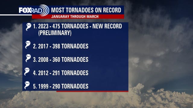

Record tornadoes reported this year, scientists say tornado alley seems to be expanding
It has been an unusually busy and early start to severe weather season and we've already seen record tornadoes being reported.
It has been an unusually busy and early start to severe weather season and we've already seen record tornadoes being reported.

Houston weather: Strong to severe storms possible starting Thursday afternoon
Strong to severe storms are possible in our area beginning north and west of Houston this afternoon, then areawide overnight tonight. The arrival time of the stormy weather has moved forward, so it now looks like weather should be pretty nice by Friday evening. Saturday still looks great, but showers could return on Sunday. Next week looks "unsettled" again.
Strong to severe storms are possible in our area beginning north and west of Houston this afternoon, then areawide overnight tonight. The arrival time of the stormy weather has moved forward, so it now looks like weather should be pretty nice by Friday evening. Saturday still looks great, but showers could return on Sunday. Next week looks "unsettled" again.
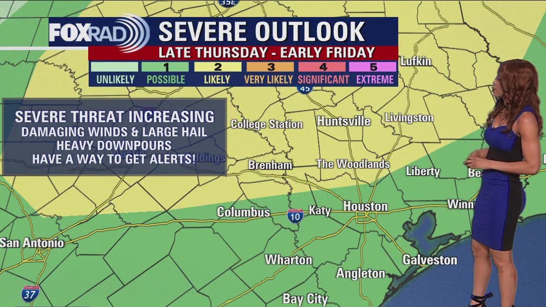

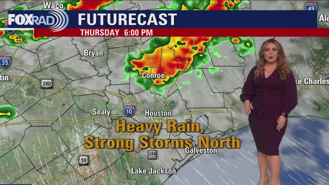
Houston weather forecast: Strong storms possible late Thursday, early Friday morning
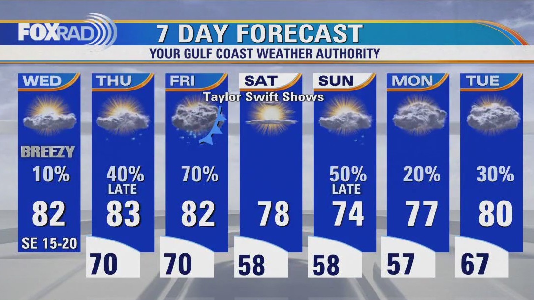
We soar to the 80s Thursday with some spotty rain & a few rumbles of thunder during the afternoon as a cold front slowly approaches. Best shot for strong to severe storms will be 7 PM Thursday through 2 AM Friday. This is when a line of storms will likely bring some strong winds, hail, heavy rain and frequent lightning. A few strong to severe storms may try to develop again Friday afternoon just ahead of the front. But it will depend on if the atmosphere can become unstable again after the early Friday AM round of storms. We dry out and cool off for Saturday with some showers returning late Sunday. Make sure to grab the FOX 26 Weather App to keep up the with the storms
We soar to the 80s Thursday with some spotty rain & a few rumbles of thunder during the afternoon as a cold front slowly approaches. Best shot for strong to severe storms will be 7 PM Thursday through 2 AM Friday. This is when a line of storms will likely bring some strong winds, hail, heavy rain and frequent lightning. A few strong to severe storms may try to develop again Friday afternoon just ahead of the front. But it will depend on if the atmosphere can become unstable again after the early Friday AM round of storms. We dry out and cool off for Saturday with some showers returning late Sunday. Make sure to grab the FOX 26 Weather App to keep up the with the storms

Wednesday evening weather forecast with Meteorologist Remeisha Shade
Other than a brief isolated shower, much of tonight should be dry. It will be mild, muggy, and breezy with overnight temperatures near 70. We soar to the 80s Thursday with some spotty rain & a few rumbles of thunder during the afternoon as a cold front slowly approaches. The best shot for strong to severe storms will be 7 PM Thursday through 2 AM Friday. This is when a line of storms will likely bring some strong winds, hail, heavy rain, and frequent lightning. A few strong to severe storms may try to develop again Friday afternoon just ahead of the front. But it will depend on if the atmosphere can become unstable again after the early Friday AM round of storms. We dry out and cool off for Saturday with some showers returning late Sunday. Make sure to grab the FOX 26 Weather App to keep up with the storms
Other than a brief isolated shower, much of tonight should be dry. It will be mild, muggy, and breezy with overnight temperatures near 70. We soar to the 80s Thursday with some spotty rain & a few rumbles of thunder during the afternoon as a cold front slowly approaches. The best shot for strong to severe storms will be 7 PM Thursday through 2 AM Friday. This is when a line of storms will likely bring some strong winds, hail, heavy rain, and frequent lightning. A few strong to severe storms may try to develop again Friday afternoon just ahead of the front. But it will depend on if the atmosphere can become unstable again after the early Friday AM round of storms. We dry out and cool off for Saturday with some showers returning late Sunday. Make sure to grab the FOX 26 Weather App to keep up with the storms

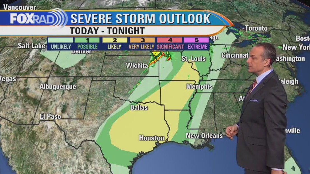
Houston weather: Timeline of late week heavy rain, strong storms possible
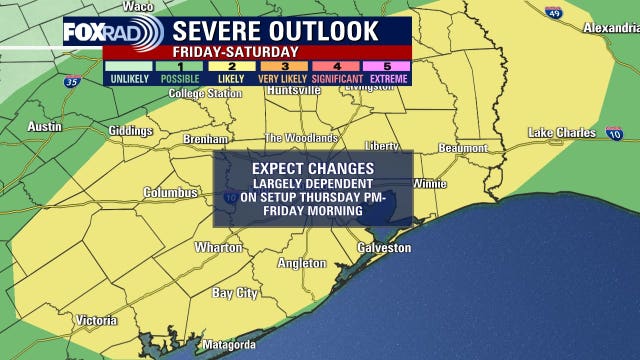
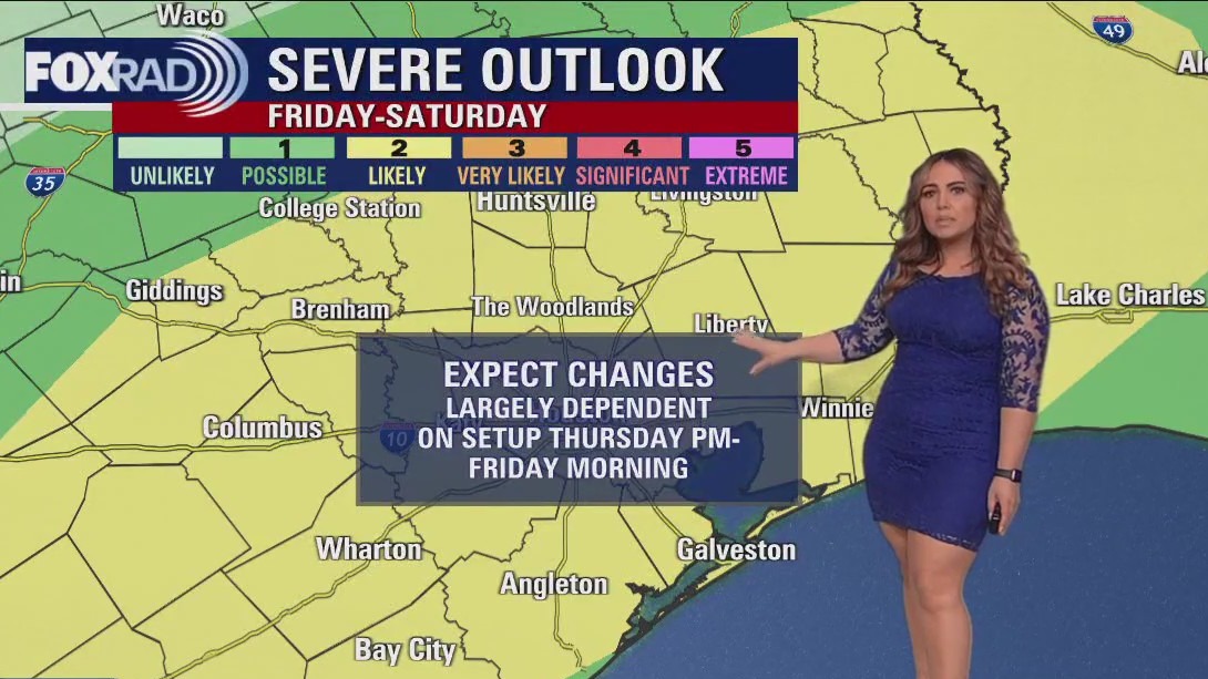
Strong to severe storms and locally heavy rainfall are possible in southeast Texas Texas as we close out the work week. So, let's dive into the nuances of the potential outcomes and how they will affect how the forecast plays out over time.
Strong to severe storms and locally heavy rainfall are possible in southeast Texas Texas as we close out the work week. So, let's dive into the nuances of the potential outcomes and how they will affect how the forecast plays out over time.

Houston air quality: Smoke from fires in Mexico reaching Texas
You may notice a light smoke or haze in the air today and tomorrow and it's coming from seasonal burning taking place in southern Mexico.
You may notice a light smoke or haze in the air today and tomorrow and it's coming from seasonal burning taking place in southern Mexico.

Houston weather: Warm temps, isolated showers Wednesday afternoon
Look for warm, breezy, and humid conditions with only isolated rain through Thursday night. The set up for active weather is a bit tricky, but for now we have 2 days with the potential for strong to severe storms and the main threats being gusty winds, locally heavy rainfall, and hail. The majority of that looks to arrive late Thursday night through early Friday and it's possible that by Friday night for the Taylor Swift concert conditions begin to clear up. The front will be off the coast by early Saturday, leading to a pleasantly dry and sunny day. Showers look to return later in the day Sunday, with on/off rain expected next week
Look for warm, breezy, and humid conditions with only isolated rain through Thursday night. The set up for active weather is a bit tricky, but for now we have 2 days with the potential for strong to severe storms and the main threats being gusty winds, locally heavy rainfall, and hail. The majority of that looks to arrive late Thursday night through early Friday and it's possible that by Friday night for the Taylor Swift concert conditions begin to clear up. The front will be off the coast by early Saturday, leading to a pleasantly dry and sunny day. Showers look to return later in the day Sunday, with on/off rain expected next week

Houston weather: Breezy Wednesday with isolated quick-moving showers
Today looks very nice, but changes are on the way. Expect a breezy day today with only isolated quick-moving showers and mild temperatures. A front approaches tomorrow and from Thursday night through Friday night there is a good chance for downpours and some possible strong to severe storms. Sunshine and dry air moves in on Saturday, but our main models are now showing a disturbance racing through on Sunday that could bring another round of rain late in the day.
Today looks very nice, but changes are on the way. Expect a breezy day today with only isolated quick-moving showers and mild temperatures. A front approaches tomorrow and from Thursday night through Friday night there is a good chance for downpours and some possible strong to severe storms. Sunshine and dry air moves in on Saturday, but our main models are now showing a disturbance racing through on Sunday that could bring another round of rain late in the day.

Houston-area weather: Isolated showers, storms possible on Wednesday, storm chances increase by the end of the week
Wednesday will be warm with only isolated showers and storms. Storms increase though Thursday PM and again Friday PM as a cold front moves in. Stay weather aware both days as we will be under the risk for a few severe storms with hail and damaging winds possible. Cold front moves through Friday night ushering in cooler and drier air for the weekend. Make your weekend plans outside now with pleasant temperatures, low humidity a good supply of sunshine expected.
Wednesday will be warm with only isolated showers and storms. Storms increase though Thursday PM and again Friday PM as a cold front moves in. Stay weather aware both days as we will be under the risk for a few severe storms with hail and damaging winds possible. Cold front moves through Friday night ushering in cooler and drier air for the weekend. Make your weekend plans outside now with pleasant temperatures, low humidity a good supply of sunshine expected.
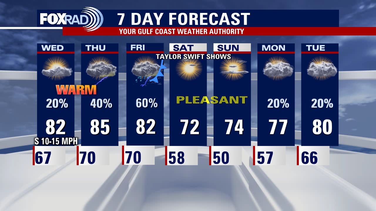

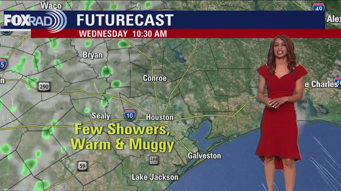
Tuesday evening weather forecast with Meteorologist Remeisha Shade
After a decent round of showers and storms this morning, things are settling down somewhat for this evening. I can't rule out a stray shower or storm but coverage will be limited compared to what some of you saw this morning. It will be mild and breezy this evening with overnight lows dipping to the upper 60s in Houston. Wednesday will be warm with only isolated showers and storms. Storms increase through Thursday PM and again Friday PM as a cold front moves in. Stay weather aware both days as we will be at the risk of a few severe storms with hail and damaging winds possible. A cold front moves through Friday night ushering in cooler and drier air for the weekend. Make your weekend plans outside now with pleasant temperatures, low humidity a good supply of sunshine expected. Have a great night!
After a decent round of showers and storms this morning, things are settling down somewhat for this evening. I can't rule out a stray shower or storm but coverage will be limited compared to what some of you saw this morning. It will be mild and breezy this evening with overnight lows dipping to the upper 60s in Houston. Wednesday will be warm with only isolated showers and storms. Storms increase through Thursday PM and again Friday PM as a cold front moves in. Stay weather aware both days as we will be at the risk of a few severe storms with hail and damaging winds possible. A cold front moves through Friday night ushering in cooler and drier air for the weekend. Make your weekend plans outside now with pleasant temperatures, low humidity a good supply of sunshine expected. Have a great night!