


Hurricane Beryl ROARING through Caribbean with MAJOR winds
Beryl is roaring through the Caribbean currently with 150mph maximum sustained winds. It should remain a major hurricane for several more days. There are concerns where it will head once it reaches the Gulf of Mexico this weekend.
Beryl is roaring through the Caribbean currently with 150mph maximum sustained winds. It should remain a major hurricane for several more days. There are concerns where it will head once it reaches the Gulf of Mexico this weekend.
Saharan dust brings haze to Houston, heat advisory and watchful eye on Hurricane Beryl
Houston anticipates a hazy week with Saharan dust as temperatures soar, prompting a heat advisory. Attention turns to Hurricane Beryl, currently tracking through the Caribbean.
Houston anticipates a hazy week with Saharan dust as temperatures soar, prompting a heat advisory. Attention turns to Hurricane Beryl, currently tracking through the Caribbean.

Hurricane Beryl becomes earliest developed Category 4 hurricane in Atlantic Basin
Beryl has now strengthened into a monster Category 4 hurricane. This is the earliest on record for the Atlantic Basin that a Cat 4 has formed. Invest 94L is still trying to become tropical before landfall and Invest 96L is ready to follow right in behind Beryl.
Beryl has now strengthened into a monster Category 4 hurricane. This is the earliest on record for the Atlantic Basin that a Cat 4 has formed. Invest 94L is still trying to become tropical before landfall and Invest 96L is ready to follow right in behind Beryl.


Hurricane Beryl forecast to become major storm with Caribbean in its path
Stay informed about the imminent threat of Hurricane Beryl, forecasted to become a major hurricane as it nears the Caribbean early next week. With substantial rainfall expected, it's crucial for residents and visitors to stay ahead of the storm.
Stay informed about the imminent threat of Hurricane Beryl, forecasted to become a major hurricane as it nears the Caribbean early next week. With substantial rainfall expected, it's crucial for residents and visitors to stay ahead of the storm.

Hurricane Beryl forecast to become major storm with Caribbean in its path
Hurricane Beryl is forecast to become a major hurricane early next week. Beryl will bring a lot of rain to the Caribbean. Stay up-to-date in the tropics by downloading our free FOX Local app on your smart tv.
Hurricane Beryl is forecast to become a major hurricane early next week. Beryl will bring a lot of rain to the Caribbean. Stay up-to-date in the tropics by downloading our free FOX Local app on your smart tv.

Tropical update: Hurricane Beryl forms in Atlantic
Beryl is now a hurricane and is expected to become a major hurricane as it moves into and through the Caribbean Sea. Invest 94L could have some major impacts on Mexico and the tropical wave off the African coast is to be watched closely for development.
Beryl is now a hurricane and is expected to become a major hurricane as it moves into and through the Caribbean Sea. Invest 94L could have some major impacts on Mexico and the tropical wave off the African coast is to be watched closely for development.

Tropical Storm Beryl could become hurricane
FOX 26 Meteorologist Allison Gargaro discusses Tropical Storm Beryl which developed in the Atlantic late Friday night and now has the chance of becoming a Category 3 Hurricane next week in the Caribbean Sea.
FOX 26 Meteorologist Allison Gargaro discusses Tropical Storm Beryl which developed in the Atlantic late Friday night and now has the chance of becoming a Category 3 Hurricane next week in the Caribbean Sea.


Tropical Storm Beryl forms in Atlantic, forecast to become hurricane
More than 3,000 miles from Houston, Tropical Storm Beryl has formed in the Atlantic Ocean, with a slight chance of reaching the Gulf some time next week.
More than 3,000 miles from Houston, Tropical Storm Beryl has formed in the Atlantic Ocean, with a slight chance of reaching the Gulf some time next week.

Tropical Update: Expecting named tropical storm
Invest 95L has a new number and that is "two", as in Tropical Depression Two. We are still expecting this system to be named Beryl, but for now the National Hurricane Center is classifying it as a tropical depression. There are also a couple other areas of disturbed weather to discuss in the Atlantic basin.
Invest 95L has a new number and that is "two", as in Tropical Depression Two. We are still expecting this system to be named Beryl, but for now the National Hurricane Center is classifying it as a tropical depression. There are also a couple other areas of disturbed weather to discuss in the Atlantic basin.

Tropical Update: Possible tropical storm developing
We are getting closer and closer to another named storm in the Atlantic! Invest 95-L in the east-central Atlantic now has a HIGH 80% chance of being our next tropical depression or storm. It is projected to get stronger as it moves west closer to the Lesser Antilles this weekend. Invest 94-L has reached the western Caribbean and still has a LOW shot to become a tropical system over the next week as it pushes into the southern Gulf of Mexico. Impacts from 94-L are expected to be minimal for Southeast Texas as it should stay to our south and move into Mexico. Another tropical wave is moving off the coast of Africa but we'll have several days to watch that one.
We are getting closer and closer to another named storm in the Atlantic! Invest 95-L in the east-central Atlantic now has a HIGH 80% chance of being our next tropical depression or storm. It is projected to get stronger as it moves west closer to the Lesser Antilles this weekend. Invest 94-L has reached the western Caribbean and still has a LOW shot to become a tropical system over the next week as it pushes into the southern Gulf of Mexico. Impacts from 94-L are expected to be minimal for Southeast Texas as it should stay to our south and move into Mexico. Another tropical wave is moving off the coast of Africa but we'll have several days to watch that one.

Tropical Update: Two systems across Atlantic Basin
We are closely monitoring two systems across the Atlantic Basin that could be our next two tropical systems. The first, Invest 94-L, is in the central Caribbean with only a low chance of development. There's a 10% chance over the next few days and a 20% chance for development as it moves into the SW Gulf of Mexico this weekend. If a tropical depression or storm forms, it would likely stay south of Houston. The other system we are monitoring is in the eastern Atlantic with only a 10% chance for development over the next few days. But conditions appear more favorable for development over the next several days as it moves west & gets closer to the Caribbean Sea. Formation potential over the next week has increased to a MEDIUM 40% chance. This system is still a long way away so keep checking back for updates!
We are closely monitoring two systems across the Atlantic Basin that could be our next two tropical systems. The first, Invest 94-L, is in the central Caribbean with only a low chance of development. There's a 10% chance over the next few days and a 20% chance for development as it moves into the SW Gulf of Mexico this weekend. If a tropical depression or storm forms, it would likely stay south of Houston. The other system we are monitoring is in the eastern Atlantic with only a 10% chance for development over the next few days. But conditions appear more favorable for development over the next several days as it moves west & gets closer to the Caribbean Sea. Formation potential over the next week has increased to a MEDIUM 40% chance. This system is still a long way away so keep checking back for updates!

Tropical Update: Chance of tropical storm in Gulf
A tropical wave in the Southeast Caribbean has a low 10% chance of developing into a tropical system over the next few days as it moves towards the Northwest Caribbean. This weekend through early next week there's a low 20% chance that we could have a tropical depression or storm in the Gulf of Mexico. This system will likely stay south of Houston but keep checking back for updates. No other tropical activity is expected in the Atlantic basin over the next few days. The Eastern Pacific also remains quiet with no tropical activity for now.
A tropical wave in the Southeast Caribbean has a low 10% chance of developing into a tropical system over the next few days as it moves towards the Northwest Caribbean. This weekend through early next week there's a low 20% chance that we could have a tropical depression or storm in the Gulf of Mexico. This system will likely stay south of Houston but keep checking back for updates. No other tropical activity is expected in the Atlantic basin over the next few days. The Eastern Pacific also remains quiet with no tropical activity for now.

Tropical Update: Watching area of possible development
Gulf of Mexico is quiet now. But we are watching another tropical wave in the SW Atlantic that could go through some very slow development as it reaches the western Caribbean by Friday. There's a LOW 20% chance of tropical development late this week over the western Caribbean and eventually the southern Gulf of Mexico. If this system develops, it would likely stay south of the Houston area and push into Mexico. But keep it here for the latest updates and check out Fox Local for the latest on the tropics and weather where you live!
Gulf of Mexico is quiet now. But we are watching another tropical wave in the SW Atlantic that could go through some very slow development as it reaches the western Caribbean by Friday. There's a LOW 20% chance of tropical development late this week over the western Caribbean and eventually the southern Gulf of Mexico. If this system develops, it would likely stay south of the Houston area and push into Mexico. But keep it here for the latest updates and check out Fox Local for the latest on the tropics and weather where you live!

Tropical Weather Forecast - June 23, 2024
TROPICS- INVEST 93L is holding running out of time but it is not done yet. La Nina years have historically seen more activity than El Nino years, let's look at the numbers.
TROPICS- INVEST 93L is holding running out of time but it is not done yet. La Nina years have historically seen more activity than El Nino years, let's look at the numbers.

Tropical Update: Possible development in Gulf
Those worried about a Tropical Disturbance near the Southeast US are here for the good news- INVEST 92L is done. All attention returns to the Gulf of Mexico as INVEST 93L is still trying to become a tropical depression before landfall.
Those worried about a Tropical Disturbance near the Southeast US are here for the good news- INVEST 92L is done. All attention returns to the Gulf of Mexico as INVEST 93L is still trying to become a tropical depression before landfall.

Tropical Update: Chance for tropical wave in Gulf
Tropical Storm Alberto is long gone but two additional areas are being monitored for Tropical development. There's a 50-60% chance that a low in the SW Atlantic could develop into a tropical depression before it reaches the coast tonight. A broad low is also expected to form in the SW Gulf of Mexico this weekend and track northwest into Mexico next week. Impacts for Southeast Texas should be minimal this time. But slightly higher tides, spotty downpours, and a high rip currents risk will likely stick around next week.
Tropical Storm Alberto is long gone but two additional areas are being monitored for Tropical development. There's a 50-60% chance that a low in the SW Atlantic could develop into a tropical depression before it reaches the coast tonight. A broad low is also expected to form in the SW Gulf of Mexico this weekend and track northwest into Mexico next week. Impacts for Southeast Texas should be minimal this time. But slightly higher tides, spotty downpours, and a high rip currents risk will likely stick around next week.


Tropical Storm Alberto: 4 dead after storm makes landfall in Mexico
At least four people are dead after Tropical Storm Alberto made landfall in Mexico, bringing heavy rain and severe flooding to the northeast region.
At least four people are dead after Tropical Storm Alberto made landfall in Mexico, bringing heavy rain and severe flooding to the northeast region.

Tropical Update: Tropical Storm Alberto made landfall
Tropical Storm Alberto made landfall near Tampico, Mexico early this morning. As of this afternoon, the last Advisory has been issued for Alberto since it has fallen apart and weakened over Mexico. Coastal Flood Warnings end this evening but watch out for roads that may still be flooded from storm surge. It's still breezy with gusts near 30 mph but the Wind Advisory has come to an end. Rip current risk remains high at area beaches. There are two additional areas of possible tropical development. One has a 40% chance to turn into a tropical system in the SW Atlantic over the next few days. The other has a MEDIUM 50% chance to become a Tropical depression or storm in the SW Gulf over the next 7 days.
Tropical Storm Alberto made landfall near Tampico, Mexico early this morning. As of this afternoon, the last Advisory has been issued for Alberto since it has fallen apart and weakened over Mexico. Coastal Flood Warnings end this evening but watch out for roads that may still be flooded from storm surge. It's still breezy with gusts near 30 mph but the Wind Advisory has come to an end. Rip current risk remains high at area beaches. There are two additional areas of possible tropical development. One has a 40% chance to turn into a tropical system in the SW Atlantic over the next few days. The other has a MEDIUM 50% chance to become a Tropical depression or storm in the SW Gulf over the next 7 days.

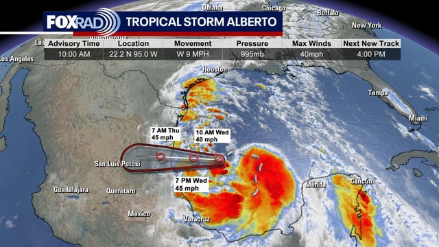
Tropical Update: Tropical Storm Alberto in the Gulf
Tropical Storm Alberto formed in the SW Gulf of Mexico this morning around 10 AM and should make landfall in eastern Mexico overnight. Alberto will bring waves of heavy rain to SE Texas through this evening along with gusty winds and coastal flooding. Some roads along the coast are impassable due to storm surge flooding. Wind should gradually subside and heaviest rain will push west Thursday as Alberto moves farther away and weakens over land. Keep track of the latest Tropical forecast on our smart tv app FOX Local and download our FOX 26 Weather App!
Tropical Storm Alberto formed in the SW Gulf of Mexico this morning around 10 AM and should make landfall in eastern Mexico overnight. Alberto will bring waves of heavy rain to SE Texas through this evening along with gusty winds and coastal flooding. Some roads along the coast are impassable due to storm surge flooding. Wind should gradually subside and heaviest rain will push west Thursday as Alberto moves farther away and weakens over land. Keep track of the latest Tropical forecast on our smart tv app FOX Local and download our FOX 26 Weather App!

Weather in Houston: Tropical Storm Alberto forms, Gulf Coast faces flood risk
Residents along the Gulf Coast are advised to prepare for Tropical Storm Alberto, which has officially formed from the Potential Tropical Cyclone #1
Residents along the Gulf Coast are advised to prepare for Tropical Storm Alberto, which has officially formed from the Potential Tropical Cyclone #1