


Hawaii turns watchful eye to Hurricane Kiko as storm returns to Category 4 strength
While the islands are in the five-day forecast cone, meteorologists said that Kiko will be a completely different storm by the time it approaches Hawaii early next week.
While the islands are in the five-day forecast cone, meteorologists said that Kiko will be a completely different storm by the time it approaches Hawaii early next week.

Tropical Weather Forecast - Closely monitoring Invest 91L in Atlantic
A tropical wave in the eastern Atlantic, now Invest 91L, still has a high chance for development over the next week. In the short-term, it's encountering dry air which is limiting showers and storms. It is still expected to become a tropical depression and possibly Tropical Storm Gabrielle by next week, but it's very far away and not a threat to Texas at this time. It could become a threat to the Lesser Antilles by the middle of next week. Download FOX Local for the latest tropical updates.
A tropical wave in the eastern Atlantic, now Invest 91L, still has a high chance for development over the next week. In the short-term, it's encountering dry air which is limiting showers and storms. It is still expected to become a tropical depression and possibly Tropical Storm Gabrielle by next week, but it's very far away and not a threat to Texas at this time. It could become a threat to the Lesser Antilles by the middle of next week. Download FOX Local for the latest tropical updates.

Tropical Weather Forecast - Watching Lorena and Invest 91L
In the tropics, Lorena in the eastern Pacific Ocean has weakened today to a tropical storm near the Baja California Peninsula. It's starting to spread clouds and some heavy downpours into an area from Tucson, AZ to El Paso. This system will not have a big, direct impact on Houston, but will probably play a role in increasing our chance for showers and storms on Sunday. A tropical wave in the eastern Atlantic, now Invest 91L, has a high chance for development over the next week. It is still expected to become Tropical Storm Gabrielle in a few days, but it's very far away and not a threat to Texas at this time. It could become a threat to the Lesser Antilles by the middle of next week.
In the tropics, Lorena in the eastern Pacific Ocean has weakened today to a tropical storm near the Baja California Peninsula. It's starting to spread clouds and some heavy downpours into an area from Tucson, AZ to El Paso. This system will not have a big, direct impact on Houston, but will probably play a role in increasing our chance for showers and storms on Sunday. A tropical wave in the eastern Atlantic, now Invest 91L, has a high chance for development over the next week. It is still expected to become Tropical Storm Gabrielle in a few days, but it's very far away and not a threat to Texas at this time. It could become a threat to the Lesser Antilles by the middle of next week.

Tropical Weather Forecast - Watching Hurricane Lorena, other possible storm development
A hurricane named Lorena is bringing wind and rain to Cabo San Lucas and the Baja California peninsula and could eventually bring a shot of rain to the Southwest. A long stretch of land from far southern California through southern Arizona, New Mexico and Texas could get a shot of rain from the storm's remnants this weekend. For now, the forecast is not certain, but locally, we expect increasing rain Sunday and Monday. In the Atlantic, the next tropical storm could form this week very far from Texas in the middle of the ocean and we'll monitor it for any surprises. But it doesn't look like a threat for now.
A hurricane named Lorena is bringing wind and rain to Cabo San Lucas and the Baja California peninsula and could eventually bring a shot of rain to the Southwest. A long stretch of land from far southern California through southern Arizona, New Mexico and Texas could get a shot of rain from the storm's remnants this weekend. For now, the forecast is not certain, but locally, we expect increasing rain Sunday and Monday. In the Atlantic, the next tropical storm could form this week very far from Texas in the middle of the ocean and we'll monitor it for any surprises. But it doesn't look like a threat for now.


Tropical wave in Atlantic could become tropical storm: path, tracker, radar
The National Hurricane Center is tracking a tropical wave in the Atlantic that could soon become Tropical Storm Gabrielle and keeping an eye on Hurricane Lorena in the Pacific.
The National Hurricane Center is tracking a tropical wave in the Atlantic that could soon become Tropical Storm Gabrielle and keeping an eye on Hurricane Lorena in the Pacific.


Hawaii keeps watch on Hurricane Kiko with models showing near miss
Hurricane Kiko has intensified into a Category 2 storm with winds of 105 mph as it tracks westward across the Pacific.
Hurricane Kiko has intensified into a Category 2 storm with winds of 105 mph as it tracks westward across the Pacific.

Tropical Weather Forecast - September 2, 2025
A tropical wave is located over the far eastern tropical Atlantic southwest of the Cabo Verde islands and continues to produce disorganized showers and thunderstorms. Environmental conditions remain conducive for gradual development of this system during the next several days, and a tropical depression is likely to form late this week or this weekend. This system is expected to initially move slowly westward and then gradually accelerate west-northwestward at around 15 mph across the eastern and central tropical Atlantic.
A tropical wave is located over the far eastern tropical Atlantic southwest of the Cabo Verde islands and continues to produce disorganized showers and thunderstorms. Environmental conditions remain conducive for gradual development of this system during the next several days, and a tropical depression is likely to form late this week or this weekend. This system is expected to initially move slowly westward and then gradually accelerate west-northwestward at around 15 mph across the eastern and central tropical Atlantic.

Tropical Weather Forecast - September 1, 2025
A tropical wave located over the far eastern tropical Atlantic south-southeast of the Cabo Verde islands is producing disorganized showers and thunderstorms. Environmental conditions appear conducive for gradual development of this system, and a tropical depression could form by the middle or later part of this week. This system is expected to move west-northwestward at 15 mph across the eastern and central tropical Atlantic throughout the week.
A tropical wave located over the far eastern tropical Atlantic south-southeast of the Cabo Verde islands is producing disorganized showers and thunderstorms. Environmental conditions appear conducive for gradual development of this system, and a tropical depression could form by the middle or later part of this week. This system is expected to move west-northwestward at 15 mph across the eastern and central tropical Atlantic throughout the week.

Espnman Survival Utility Shovel | Hurricane Gear Test
On this Hurricane Gear Test, meteorologist John Dawson shows us the compact Espnman Survival Utility Shovel with 15 separate functions.
On this Hurricane Gear Test, meteorologist John Dawson shows us the compact Espnman Survival Utility Shovel with 15 separate functions.


Blue Ridge Parkway reopens critical stretch just ahead of fall foliage season
Damage caused by a landslide near Devil’s Courthouse was repaired, making an 85-mile stretch from Asheville down to the southern end of the Parkway continuous once again.
Damage caused by a landslide near Devil’s Courthouse was repaired, making an 85-mile stretch from Asheville down to the southern end of the Parkway continuous once again.

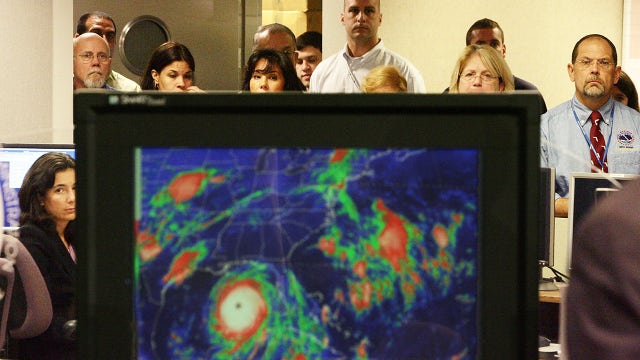
FOX Weather's Bryan Norcross reflects on Hurricane Katrina
FOX Weather's Bryan Norcross looks back on Hurricane Katrina making landfall 20 years ago while working in Miami.
FOX Weather's Bryan Norcross looks back on Hurricane Katrina making landfall 20 years ago while working in Miami.

How hurricane forecasting has changed since Katrina
Since Katrina, hurricane forecasting has improved "in almost every way imaginable," according to experts.
Since Katrina, hurricane forecasting has improved "in almost every way imaginable," according to experts.

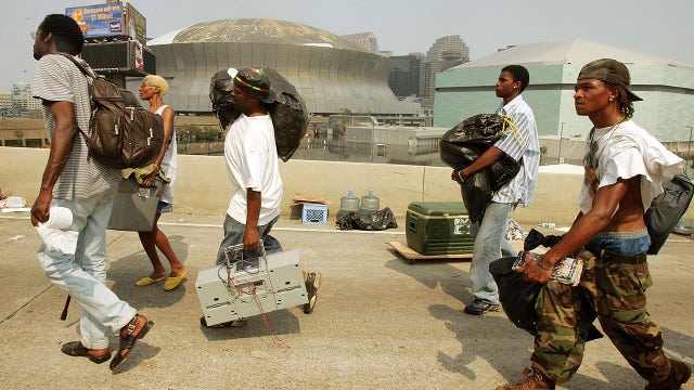
Hurricane Katrina fueled major reforms at FEMA. Now, its future is uncertain
Hurricane Katrina forced major changes in how the country responds to disasters. Now, those reforms are in jeopardy.
Hurricane Katrina forced major changes in how the country responds to disasters. Now, those reforms are in jeopardy.

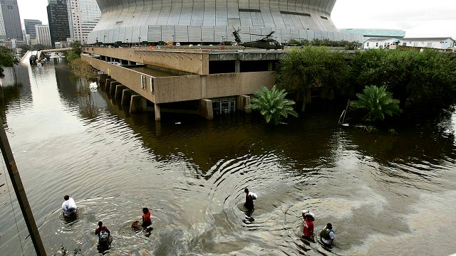
Hurricane Katrina: What happened on Aug. 29, 2005
On Aug. 29, 2005, Hurricane Katrina made landfall in New Orleans, causing levee breaches that sparked massive flooding, displacing thousands. The natural disaster exposed flaws in the federal government’s response and the media’s coverage of the tragedy.
On Aug. 29, 2005, Hurricane Katrina made landfall in New Orleans, causing levee breaches that sparked massive flooding, displacing thousands. The natural disaster exposed flaws in the federal government’s response and the media’s coverage of the tragedy.
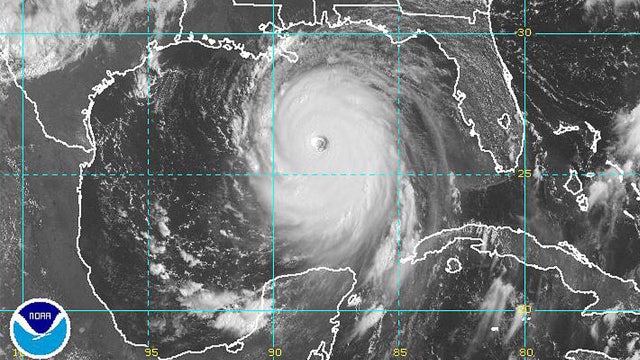

20 years ago, the National Weather Service issued its most chilling warning ever
The National Weather Service warned of severe destruction and uninhabitable conditions ahead of Hurricane Katrina's landfall.
The National Weather Service warned of severe destruction and uninhabitable conditions ahead of Hurricane Katrina's landfall.

Tropical weather forecast - August 28, 2025
Fernand has become post-tropical and is no longer being monitored by the National Hurricane Center. The Gulf and The Caribbean are quiet but the tropical waves continue to roll off the west coast of Africa. The latest one should pass south of the Cape Verde Islands on Sunday and has a low chance for development into a tropical cyclone over the next 7 days.
Fernand has become post-tropical and is no longer being monitored by the National Hurricane Center. The Gulf and The Caribbean are quiet but the tropical waves continue to roll off the west coast of Africa. The latest one should pass south of the Cape Verde Islands on Sunday and has a low chance for development into a tropical cyclone over the next 7 days.

Tropical Weather Update - August 27, 2025
Tropical Storm Fernand is a little stronger but still disorganized in the Central Atlantic. It should lose tropical characteristics tonight or tomorrow as it heads into the colder water and harsh jet stream current in the north Atlantic. Elsewhere, there are a few weak tropical waves including one in the Caribbean that are unlikely to organize over the next few days. Remember to stay alert as the peak of hurricane season is approaching in a couple of weeks.
Tropical Storm Fernand is a little stronger but still disorganized in the Central Atlantic. It should lose tropical characteristics tonight or tomorrow as it heads into the colder water and harsh jet stream current in the north Atlantic. Elsewhere, there are a few weak tropical waves including one in the Caribbean that are unlikely to organize over the next few days. Remember to stay alert as the peak of hurricane season is approaching in a couple of weeks.

Tropical Weather Forecast - August 26, 2025
Tropical Storm Fernand is not going down in the history books as anything remarkable. It should fizzle later today and tomorrow as it heads into the colder water and harsh jet stream current in the north Atlantic. Elsewhere, there are a few weak tropical waves including one in the Caribbean that are unlikely to organize over the next few days. So things are fairly quiet in the tropics. However, we are about to enter into what is usually the busiest month of the hurricane season, September. So stay alert and be ready to take action if a tropical system heads towards us.
Tropical Storm Fernand is not going down in the history books as anything remarkable. It should fizzle later today and tomorrow as it heads into the colder water and harsh jet stream current in the north Atlantic. Elsewhere, there are a few weak tropical waves including one in the Caribbean that are unlikely to organize over the next few days. So things are fairly quiet in the tropics. However, we are about to enter into what is usually the busiest month of the hurricane season, September. So stay alert and be ready to take action if a tropical system heads towards us.

Tropical Weather Forecast - August 25, 2025
The season's sixth tropical storm, Fernand, is not much of a story in the middle of the Atlantic Ocean. It has avoided any land and is a small system with winds near 60 mph. It will move to the north and northeast, likely losing tropical characteristics by Wednesday. Elsewhere, a tropical wave just entering the Caribbean doesn't look impressive and is unlikely to get stronger. Development chance for Invest 99L is now down to near 0%. We will continue to keep a close eye on the entire Atlantic basin as we near the peak of hurricane season on September 10.
The season's sixth tropical storm, Fernand, is not much of a story in the middle of the Atlantic Ocean. It has avoided any land and is a small system with winds near 60 mph. It will move to the north and northeast, likely losing tropical characteristics by Wednesday. Elsewhere, a tropical wave just entering the Caribbean doesn't look impressive and is unlikely to get stronger. Development chance for Invest 99L is now down to near 0%. We will continue to keep a close eye on the entire Atlantic basin as we near the peak of hurricane season on September 10.

ZOLEO Satellite Communicator | JD's Hurricane Gear Test
We rely on our phones to keep us connected, especially during a storm. But, what happens if the cell phone tower gets damaged and stops working. In this segment of JD's Hurricane Gear Test, JD reviews the Zoleo Satellite Communicator.
We rely on our phones to keep us connected, especially during a storm. But, what happens if the cell phone tower gets damaged and stops working. In this segment of JD's Hurricane Gear Test, JD reviews the Zoleo Satellite Communicator.