


Hurricane Gear Test: Life+Gear Pro Survivor Premium 72 Hour Pack
As we hit the peak of hurricane season, prebuilt emergency kits are more accessible than ever. But before you buy one, meteorologist John Dawson reviews a trusted survival pack and shares important tips for staying prepared.
As we hit the peak of hurricane season, prebuilt emergency kits are more accessible than ever. But before you buy one, meteorologist John Dawson reviews a trusted survival pack and shares important tips for staying prepared.

Tropical Cyclone Eight Forms | Tropical update
Potential Tropical Cyclone EIGHT has formed off the coast of South Carolina. This system will bring heavy rain and possible coastal flooding early this week. Gordon has been downgraded to a Tropical Depression but could become stronger later in the week.
Potential Tropical Cyclone EIGHT has formed off the coast of South Carolina. This system will bring heavy rain and possible coastal flooding early this week. Gordon has been downgraded to a Tropical Depression but could become stronger later in the week.

Tropical Storm Gordan in Atlantic: Tropical update
Tropical Storm Gordon is out in the Atlantic but an area of low pressure of the coast of The Carolinas is much more of a concern. Gordon will struggle and stay out in the Atlantic but heavy rain and the chance for flooding will find its way to the East Coast of the US.
Tropical Storm Gordon is out in the Atlantic but an area of low pressure of the coast of The Carolinas is much more of a concern. Gordon will struggle and stay out in the Atlantic but heavy rain and the chance for flooding will find its way to the East Coast of the US.

Watching 2 systems in the Atlantic | FOX 26 Tropical Weather Update
Post Tropical Francine is still bringing heavy rain to parts of the Tennessee Valley and the southeast. Francine is expected to fall apart and dissipate by tonight. Today Tropical Storm Gordon became the 7th named storm of the 2024 Atlantic hurricane season in the central Atlantic. It is running into some dry air and is not forecast to become a hurricane at this point. It should also stay over water for the next several days. Invest 94-L near the Leeward Islands now has a 0% chance for development. Area off of SE U.S. coast has a medium 40% chance for a tropical system to develop over the next 7 days.
Post Tropical Francine is still bringing heavy rain to parts of the Tennessee Valley and the southeast. Francine is expected to fall apart and dissipate by tonight. Today Tropical Storm Gordon became the 7th named storm of the 2024 Atlantic hurricane season in the central Atlantic. It is running into some dry air and is not forecast to become a hurricane at this point. It should also stay over water for the next several days. Invest 94-L near the Leeward Islands now has a 0% chance for development. Area off of SE U.S. coast has a medium 40% chance for a tropical system to develop over the next 7 days.

How St. Mary parish residents dealt with Francine
Hurricane Francine passed over Louisiana leaving severe damage. FOX 26's Sherman Desselle is in St. Mary parish speaking with residents about how they're recovering.
Hurricane Francine passed over Louisiana leaving severe damage. FOX 26's Sherman Desselle is in St. Mary parish speaking with residents about how they're recovering.

Louisiana residents assess Francine damage
Francine has downgraded to a tropical depression bringing heavy rain across the South. FOX's Bown Kedrowicz is in Reserve, Louisiana where people are working on recovering after the storm.
Francine has downgraded to a tropical depression bringing heavy rain across the South. FOX's Bown Kedrowicz is in Reserve, Louisiana where people are working on recovering after the storm.

Ferocious Francine slams Louisiana ripping roofs from buildings, trapping residents amid rising floodwaters
Francine has since been downgraded to a tropical depression, but the storm’s dangerous and life-threatening impacts are expected to continue well inland.
Francine has since been downgraded to a tropical depression, but the storm’s dangerous and life-threatening impacts are expected to continue well inland.


More on Hurricane Francine's landfall in Louisiana
Hurricane Francine made landfall in southern Louisiana about 30 miles SW of Morgan City in Terrebone Parish shortly before 5 pm. At time of landfall, winds were around 100 mph.
Hurricane Francine made landfall in southern Louisiana about 30 miles SW of Morgan City in Terrebone Parish shortly before 5 pm. At time of landfall, winds were around 100 mph.

Hurricane Francine leaves high water in Galveston
The back end of Hurricane Francine just grazed Galveston on Wednesday. FOX 26's Leslie DelasBour spent the day there to speak with residents who are faced with high water.
The back end of Hurricane Francine just grazed Galveston on Wednesday. FOX 26's Leslie DelasBour spent the day there to speak with residents who are faced with high water.

Hurricane Francine pounds Louisiana
Hurricane Francine has hit Louisiana and FOX 26's Sherman Desselle is there to get a look at what's happening on the ground.
Hurricane Francine has hit Louisiana and FOX 26's Sherman Desselle is there to get a look at what's happening on the ground.

Francine intensifies to category 2, watching other development
FOX 26 Meteorologists Remeisha Shade and John Dawson have the latest on Hurricane Francine as well as other developments occurring out in the Atlantic
FOX 26 Meteorologists Remeisha Shade and John Dawson have the latest on Hurricane Francine as well as other developments occurring out in the Atlantic

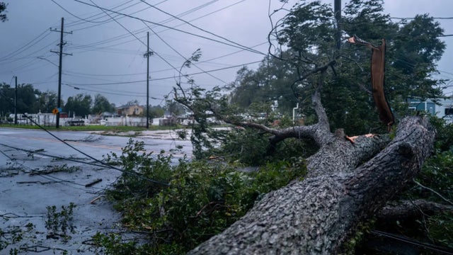
Hurricane Francine makes landfall in southern Louisiana
Hurricane Francine barreled into southern Louisiana on Wednesday evening as a category 2 storm, making landfall with destructive 100 mph winds and dangerous storm surge along the Bayou state's coastline.
Hurricane Francine barreled into southern Louisiana on Wednesday evening as a category 2 storm, making landfall with destructive 100 mph winds and dangerous storm surge along the Bayou state's coastline.

Tropical update: Francine nears Louisiana coast
Francine is still a 65 mph tropical storm with a high likelihood to become a hurricane by this evening. It is still forecast to hit the middle Louisiana Gulf coast with dangerous storm surge, flooding rain & hurricane force winds in cities like Lafayette, Baton Rouge & Morgan City. Tropical Storm Watch has been canceled for SE Texas but a Coastal Flood Warning remains in place for coastal areas. The main risk will be for storm surge around 1-3' that could flood some streets. Winds could also gust closer to 40 mph, especially near the coast. Look for spotty downpours and breezy conditions Wednesday before Francine quickly pulls away from SE Texas.
Francine is still a 65 mph tropical storm with a high likelihood to become a hurricane by this evening. It is still forecast to hit the middle Louisiana Gulf coast with dangerous storm surge, flooding rain & hurricane force winds in cities like Lafayette, Baton Rouge & Morgan City. Tropical Storm Watch has been canceled for SE Texas but a Coastal Flood Warning remains in place for coastal areas. The main risk will be for storm surge around 1-3' that could flood some streets. Winds could also gust closer to 40 mph, especially near the coast. Look for spotty downpours and breezy conditions Wednesday before Francine quickly pulls away from SE Texas.


Tropical Storm Francine: Galveston County prepares for impacts
A coastal flood warning has been issued for low-lying areas as Tropical Storm Francine approaches the Gulf of Mexico. Coastal communities are preparing for potential flooding and other impacts.
A coastal flood warning has been issued for low-lying areas as Tropical Storm Francine approaches the Gulf of Mexico. Coastal communities are preparing for potential flooding and other impacts.

Tracking Francine, along with two other tropical systems | FOX 26 Tropical Weather Forecast
FOX 26 Meteorologist Remeisha Shade has the latest track for Tropical Storm Francine, which is forecast to become a category 2 hurricane before landfall on the Louisiana coast on Wednesday afternoon.
FOX 26 Meteorologist Remeisha Shade has the latest track for Tropical Storm Francine, which is forecast to become a category 2 hurricane before landfall on the Louisiana coast on Wednesday afternoon.

Affordable tips for hurricane season | Sullivan?s Smart Sense/Hurricane Gear Test
With Hurricane season at its peak, consumer reporter Heather Sullivan and meteorologist John Dawson show you how to prepare on a budget.
With Hurricane season at its peak, consumer reporter Heather Sullivan and meteorologist John Dawson show you how to prepare on a budget.

Tropical update: Invest 91L high chance of developing
A disorganized area of low pressure near the Bay of Campeche will become more organized over the next few days and move northward towards the Texas coast. The National Hurricane Center has labeled this disturbance as Invest 91L and has given it a 70% chance forming into a tropical depression or tropical storm.
A disorganized area of low pressure near the Bay of Campeche will become more organized over the next few days and move northward towards the Texas coast. The National Hurricane Center has labeled this disturbance as Invest 91L and has given it a 70% chance forming into a tropical depression or tropical storm.

Watching 4 areas of disturbed weather | FOX 26 Tropical Weather Forecast
A broad area of low pressure off of the Texas coast will not be a tropical system but will keep scattered showers in the Houston area through early tonight. Cold front dropping in from the north should end rain chances for the weekend. However, disturbance crossing over Yucatan Peninsula now has a MEDIUM chance to be our next tropical depression or storm over the next week. It should remain south of the Houston area but will bring higher rain chances as we go through next week. Disturbance over east-central Atlantic also has a low chance for development over the next
A broad area of low pressure off of the Texas coast will not be a tropical system but will keep scattered showers in the Houston area through early tonight. Cold front dropping in from the north should end rain chances for the weekend. However, disturbance crossing over Yucatan Peninsula now has a MEDIUM chance to be our next tropical depression or storm over the next week. It should remain south of the Houston area but will bring higher rain chances as we go through next week. Disturbance over east-central Atlantic also has a low chance for development over the next

Watching 5 disturbances in the Atlantic | FOX 26 Tropical Weather Forecast
The National Hurricane Center is watching a whopping five disturbances in the Atlantic basin with the chance for tropical development. One broad area of low pressure along a weak front in the northern Gulf has a 10% chance for tropical development. It will continue to spread more downpours along parts of the Gulf coast. Another disturbance in the western Caribbean has a low 20% chance to become a tropical system in the SW Gulf over the next week. Two other systems are being monitored in the Atlantic with a slim 10-20% chance for survival. Invest 99-L in NW Atlantic now has a 30% shot to become a brief tropical or subtropical system before moving into cooler waters this weekend.
The National Hurricane Center is watching a whopping five disturbances in the Atlantic basin with the chance for tropical development. One broad area of low pressure along a weak front in the northern Gulf has a 10% chance for tropical development. It will continue to spread more downpours along parts of the Gulf coast. Another disturbance in the western Caribbean has a low 20% chance to become a tropical system in the SW Gulf over the next week. Two other systems are being monitored in the Atlantic with a slim 10-20% chance for survival. Invest 99-L in NW Atlantic now has a 30% shot to become a brief tropical or subtropical system before moving into cooler waters this weekend.

Watching tropical waves for possible development in Atlantic
National hurricane center is now monitoring four disturbances with a low chance for tropical development. Newest area being monitored is a few hundred miles east of North Carolina and disorganized. It's moving NE away from the United States and has a low 10-20% chance of briefly becoming subtropical. Tropical wave in the central Caribbean still has a 30% chance of development over the next week and is forecast to reach the SW Gulf of Mexico by this weekend. It should stay south of the Houston area with a cold front keeping it south. Two other tropical waves are being monitored in the Atlantic with a low chance for some slow development over the next seven days.
National hurricane center is now monitoring four disturbances with a low chance for tropical development. Newest area being monitored is a few hundred miles east of North Carolina and disorganized. It's moving NE away from the United States and has a low 10-20% chance of briefly becoming subtropical. Tropical wave in the central Caribbean still has a 30% chance of development over the next week and is forecast to reach the SW Gulf of Mexico by this weekend. It should stay south of the Houston area with a cold front keeping it south. Two other tropical waves are being monitored in the Atlantic with a low chance for some slow development over the next seven days.