

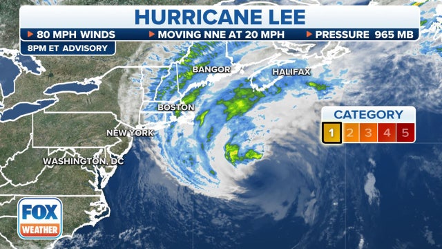

Sprawling Hurricane Lee's impacts begin as winds, power outages increase in New England
While the center of the storm will likely stay east of the U.S. and move into the Canadian Maritimes, Lee's massive wind field is hundreds of miles across and will not spare the New England coast from its wrath.
While the center of the storm will likely stay east of the U.S. and move into the Canadian Maritimes, Lee's massive wind field is hundreds of miles across and will not spare the New England coast from its wrath.

Tropical Weather Forecast - September 15, 2023
We are still around the peak of hurricane season and the tropics remain pretty busy with Hurricane Lee, Tropical Storm Margot, and newly formed Tropical Depression #15. Tropical storm warnings are out for parts of the New England coast and Atlantic Canada as Lee moves closer. Lee will bring the threat for strong winds, dangerous surf, and coastal flooding to these areas over the next 24-36 hours. Lee is a Category one hurricane but should transition to a post-tropical system over the weekend. Margot will not have an impact on land. Tropical Depression 15 is expected to become a major hurricane by the middle of next week and approach Bermuda.
We are still around the peak of hurricane season and the tropics remain pretty busy with Hurricane Lee, Tropical Storm Margot, and newly formed Tropical Depression #15. Tropical storm warnings are out for parts of the New England coast and Atlantic Canada as Lee moves closer. Lee will bring the threat for strong winds, dangerous surf, and coastal flooding to these areas over the next 24-36 hours. Lee is a Category one hurricane but should transition to a post-tropical system over the weekend. Margot will not have an impact on land. Tropical Depression 15 is expected to become a major hurricane by the middle of next week and approach Bermuda.

FOX 26 Friday evening weather forecast
Strong to severe storms have been rolling across SE TX with the threat for flooding, damaging winds and hail. We need the heavy rain but watch out for some street flooding. Flash Flood Warning is in effect for SE Harris and NW Galveston counties until 7:30 pm. 2-4" of rain have fallen in this area and some flooding is likely through early evening. Look for isolated to spotty showers and storms this weekend with near average temperatures in the low 90s. The trend for next week is less rain and a little more heat as we climb to the middle 90s.
Strong to severe storms have been rolling across SE TX with the threat for flooding, damaging winds and hail. We need the heavy rain but watch out for some street flooding. Flash Flood Warning is in effect for SE Harris and NW Galveston counties until 7:30 pm. 2-4" of rain have fallen in this area and some flooding is likely through early evening. Look for isolated to spotty showers and storms this weekend with near average temperatures in the low 90s. The trend for next week is less rain and a little more heat as we climb to the middle 90s.


Houston weather: Flash Flood warning issued for Harris County area, CenterPoint power outages
A flash flood warning has been issued for an area of Harris County on Friday evening due to thunderstorms and CenterPoint Energy reports at least 30,000 people without power.
A flash flood warning has been issued for an area of Harris County on Friday evening due to thunderstorms and CenterPoint Energy reports at least 30,000 people without power.
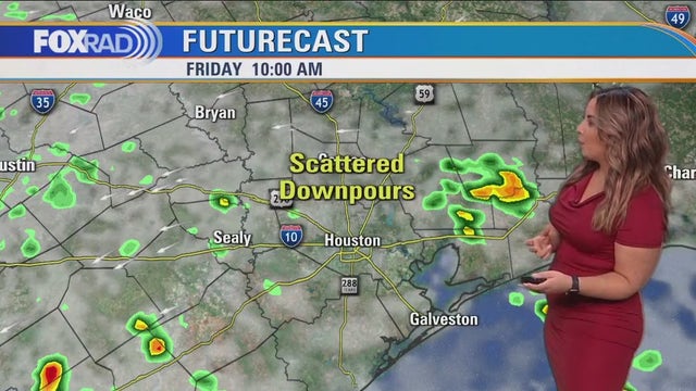

Houston Weather: Rain returns for the weekend
Scattered storms return Friday, including the possibility of a few stronger storms and downpours. Rain looks more isolated in nature for Saturday. The end of the weekend and next week start off nicely.
Scattered storms return Friday, including the possibility of a few stronger storms and downpours. Rain looks more isolated in nature for Saturday. The end of the weekend and next week start off nicely.

FOX 26 Houston Weather Forecast
Scattered storms return today, including the possibility for a few stronger storms and downpours. Rain looks more isolated in nature for tomorrow. The end of the weekend and next week start off nice! Temperatures look to remain reasonable next week, with a few midweek showers possible. Margot is still a Hurricane, but impacting no one in the north-central Atlantic. Lee is brushing by Bermuda, then New England and Coastal Canada heading into the weekend. There are two other areas to watch in the Atlantic, with no local threats at this time.
Scattered storms return today, including the possibility for a few stronger storms and downpours. Rain looks more isolated in nature for tomorrow. The end of the weekend and next week start off nice! Temperatures look to remain reasonable next week, with a few midweek showers possible. Margot is still a Hurricane, but impacting no one in the north-central Atlantic. Lee is brushing by Bermuda, then New England and Coastal Canada heading into the weekend. There are two other areas to watch in the Atlantic, with no local threats at this time.

FOX 26 Houston Weather Forecast
Scattered storms return today, including the possibility for a few stronger storms and downpours. Rain looks more isolated in nature for tomorrow. The end of the weekend and next week start off nice! Temperatures look to remain reasonable next week, with a few midweek showers possible. Margot is still a hurricane, but impacting no one in the north-central Atlantic. Lee is brushing by Bermuda, then New England and Coastal Canada heading into the weekend. There are two other areas to watch in the Atlantic, with no local threats at this time.
Scattered storms return today, including the possibility for a few stronger storms and downpours. Rain looks more isolated in nature for tomorrow. The end of the weekend and next week start off nice! Temperatures look to remain reasonable next week, with a few midweek showers possible. Margot is still a hurricane, but impacting no one in the north-central Atlantic. Lee is brushing by Bermuda, then New England and Coastal Canada heading into the weekend. There are two other areas to watch in the Atlantic, with no local threats at this time.

FOX 26 Houston Weather Forecast
More widespread beneficial rain has arrived across SE Texas with the threat for a few strong to severe storms also possible. Main threats with these storms will be isolated damaging winds, hail around 1" and very heavy rain that could lead to some street flooding. Some of these storms have dumped 1-3" of rain across the area today helping with the worsening drought conditions. Best storm chance will be through early tonight but a few showers and storms will be possible overnight. We will repeat this again Friday with another round of storms expected during the afternoon and evening. Rain chances get lower this weekend, around 30-40%. Looking ahead to next week, isolated rain will stick around with temperatures climbing back up to the middle 90s as our heat dome tries to build back in.
More widespread beneficial rain has arrived across SE Texas with the threat for a few strong to severe storms also possible. Main threats with these storms will be isolated damaging winds, hail around 1" and very heavy rain that could lead to some street flooding. Some of these storms have dumped 1-3" of rain across the area today helping with the worsening drought conditions. Best storm chance will be through early tonight but a few showers and storms will be possible overnight. We will repeat this again Friday with another round of storms expected during the afternoon and evening. Rain chances get lower this weekend, around 30-40%. Looking ahead to next week, isolated rain will stick around with temperatures climbing back up to the middle 90s as our heat dome tries to build back in.
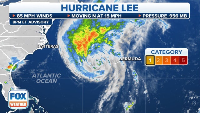

Tropical Storm Warnings expanded across New England as Hurricane Lee makes final approach
Boston could see sustained tropical-storm-force-winds by Friday evening through the first part of the weekend, and concerns are growing that with leaves still on trees the expected wind and possible heavy rain could snap branches and limbs and pull down power lines, leaving thousands of people in the dark.
Boston could see sustained tropical-storm-force-winds by Friday evening through the first part of the weekend, and concerns are growing that with leaves still on trees the expected wind and possible heavy rain could snap branches and limbs and pull down power lines, leaving thousands of people in the dark.

FOX 26 Thursday weather forecast
More widespread beneficial rain has arrived across SE Texas with the threat for a few strong to severe storms also possible. Main threats with these storms will be isolated damaging winds, hail around 1" and very heavy rain that could lead to some street flooding. Some of these storms have dumped 1-3" of rain across the area today helping with the worsening drought conditions. Best storm chance will be through early tonight but a few showers and storms will be possible overnight. We will repeat this again Friday with another round of storms expected during the afternoon and evening. Rain chances get lower this weekend, around 30-40%. Looking ahead to next week, isolated rain will stick around with temperatures climbing back up to the middle 90s as our heat dome tries to build back in.
More widespread beneficial rain has arrived across SE Texas with the threat for a few strong to severe storms also possible. Main threats with these storms will be isolated damaging winds, hail around 1" and very heavy rain that could lead to some street flooding. Some of these storms have dumped 1-3" of rain across the area today helping with the worsening drought conditions. Best storm chance will be through early tonight but a few showers and storms will be possible overnight. We will repeat this again Friday with another round of storms expected during the afternoon and evening. Rain chances get lower this weekend, around 30-40%. Looking ahead to next week, isolated rain will stick around with temperatures climbing back up to the middle 90s as our heat dome tries to build back in.

Tropical Weather Forecast - September 14, 2023
Tropical Storm Warnings are now out for parts of the NE US including Boston in preparation for the arrival of Hurricane Lee. Hurricane watches are out for parts of eastern Maine as well with strong rip currents, dangerous surf, coastal flooding and high winds expected. Lee is now passing west of Bermuda with tropical storm warnings in place there. Lee has weakened to a category 1 hurricane but should reach New England by Saturday and impact parts of Canada as well this weekend. Hurricane Margot is also a category one but will meander in the central Atlantic through this weekend and not impact land. Invest 97-L in the central Atlantic has a 90% chance to become our next named storm which would be Nigel. This system could impact parts of the US East Coast by late next week.
Tropical Storm Warnings are now out for parts of the NE US including Boston in preparation for the arrival of Hurricane Lee. Hurricane watches are out for parts of eastern Maine as well with strong rip currents, dangerous surf, coastal flooding and high winds expected. Lee is now passing west of Bermuda with tropical storm warnings in place there. Lee has weakened to a category 1 hurricane but should reach New England by Saturday and impact parts of Canada as well this weekend. Hurricane Margot is also a category one but will meander in the central Atlantic through this weekend and not impact land. Invest 97-L in the central Atlantic has a 90% chance to become our next named storm which would be Nigel. This system could impact parts of the US East Coast by late next week.

El Tiempo 14 de Septiembre de 2023
#FOX26 Meteor?loga Lena Maria Arango tiene su pron?stico para el fin de semana.
#FOX26 Meteor?loga Lena Maria Arango tiene su pron?stico para el fin de semana.
Houston weather: Severe thunderstorm warning issued for Harris County area
A Severe Thunderstorm Warning has been issued for the Harris County area on Thursday.
A Severe Thunderstorm Warning has been issued for the Harris County area on Thursday.

FOX 26 Houston Weather
Get ready for more rain and even the chance for heavy rain, isolated street flooding and isolated severe storms today. More than 2" of rain could be common after midday along with frequent lightning. If today's high temp stays below 89?, it would be the first time since June 6th! Beyond today, look for scattered storms Friday and a few showers and storms this weekend.
Get ready for more rain and even the chance for heavy rain, isolated street flooding and isolated severe storms today. More than 2" of rain could be common after midday along with frequent lightning. If today's high temp stays below 89?, it would be the first time since June 6th! Beyond today, look for scattered storms Friday and a few showers and storms this weekend.

FOX 26 Houston Weather Forecast
Houston is finally getting a decent shot for more widespread rain the next few days. Multiple rounds of rain are expected with some heavy rain possible. We are in a marginal risk for excessive rain that could lead to a little street flooding today and tomorrow. Widespread 1-2" rain totals are expected the next few days with isolated higher amounts. A few strong storms could produce some wind gusts wind near 40-50 mph. Widespread severe weather is not expected. Temperatures are more comfortable the next few days with heat building again next week. Rain chances go back to isolated by Sunday. Hurricane Lee will remains a threat to New England where hurricane and tropical storm watches are now in effect.
Houston is finally getting a decent shot for more widespread rain the next few days. Multiple rounds of rain are expected with some heavy rain possible. We are in a marginal risk for excessive rain that could lead to a little street flooding today and tomorrow. Widespread 1-2" rain totals are expected the next few days with isolated higher amounts. A few strong storms could produce some wind gusts wind near 40-50 mph. Widespread severe weather is not expected. Temperatures are more comfortable the next few days with heat building again next week. Rain chances go back to isolated by Sunday. Hurricane Lee will remains a threat to New England where hurricane and tropical storm watches are now in effect.


Deer Park hearing-impaired student influences change to city's tornado sirens
One Deer Park high school student went above and beyond to make sure all residents in Deer Park know about an emergency.
One Deer Park high school student went above and beyond to make sure all residents in Deer Park know about an emergency.
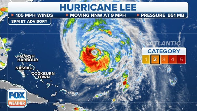

New England on alert: Hurricane and Tropical Storm watches issued for much of coastline ahead of Lee's arrival
The National Hurricane Center in coordination for local National Weather Services offices issued a Hurricane Watch from Stonington, Maine to the U.S.- Canada border and a Tropical Storm Watch is in effect for from Watch Hill, Rhode Island to Stonington, Maine.
The National Hurricane Center in coordination for local National Weather Services offices issued a Hurricane Watch from Stonington, Maine to the U.S.- Canada border and a Tropical Storm Watch is in effect for from Watch Hill, Rhode Island to Stonington, Maine.

FOX 26 Wednesday evening weather forecast
Houston is finally getting a decent shot for more widespread rain the next few days. Multiple rounds of rain are expected with some heavy rain possible. We are in a marginal risk for excessive rain that could lead to a little street flooding today and tomorrow. Widespread 1-2" rain totals are expected the next few days with isolated higher amounts. A few strong storms could produce some wind gusts wind near 40-50 mph. Widespread severe weather is not expected. Temperatures are more comfortable the next few days with heat building again next week. Rain chances go back to isolated by Sunday. Hurricane Lee will remains a threat to New England where hurricane and tropical storm watches are now in effect.
Houston is finally getting a decent shot for more widespread rain the next few days. Multiple rounds of rain are expected with some heavy rain possible. We are in a marginal risk for excessive rain that could lead to a little street flooding today and tomorrow. Widespread 1-2" rain totals are expected the next few days with isolated higher amounts. A few strong storms could produce some wind gusts wind near 40-50 mph. Widespread severe weather is not expected. Temperatures are more comfortable the next few days with heat building again next week. Rain chances go back to isolated by Sunday. Hurricane Lee will remains a threat to New England where hurricane and tropical storm watches are now in effect.

Tropical Weather Forecast - September 13, 2023
Hurricane Lee is down to a Category 2 but could still pose a risk to Bermuda where Tropical Storm warnings are in effect. Hurricane Lee is expected to get close to New England by Saturday where hurricane, tropical storm and storm surge watches are in effect. Lee will bring strong wind, the threat for Coastal flooding and dangerous surf to parts of the NE and Nova Scotia this weekend. Hurricane Margot will gradually weaken and not be a threat to land through the weekend in the north central Atlantic. Invest 97-L has a high chance to become a Tropical Depression or storm in the central Atlantic the next few days. The next name on the list would be Nigel.
Hurricane Lee is down to a Category 2 but could still pose a risk to Bermuda where Tropical Storm warnings are in effect. Hurricane Lee is expected to get close to New England by Saturday where hurricane, tropical storm and storm surge watches are in effect. Lee will bring strong wind, the threat for Coastal flooding and dangerous surf to parts of the NE and Nova Scotia this weekend. Hurricane Margot will gradually weaken and not be a threat to land through the weekend in the north central Atlantic. Invest 97-L has a high chance to become a Tropical Depression or storm in the central Atlantic the next few days. The next name on the list would be Nigel.

Fox 26 Weather Forecast
A pattern change has arrived and rain looks likely for the next few days. Our long-lived "heat dome" has dissipated and a more active jet stream pattern will replace it through at least Saturday. A few heavy downpours are possible from late today through Thursday and Friday. High temps should be held to at or even below average which will be a nice break. Today is the 15th anniversary of Hurricane Ike making landfall in Galveston, but we are currently not under any tropical threats.
A pattern change has arrived and rain looks likely for the next few days. Our long-lived "heat dome" has dissipated and a more active jet stream pattern will replace it through at least Saturday. A few heavy downpours are possible from late today through Thursday and Friday. High temps should be held to at or even below average which will be a nice break. Today is the 15th anniversary of Hurricane Ike making landfall in Galveston, but we are currently not under any tropical threats.