


Pasadena Animal Shelter still in need of help nearly a week after devastating tornado
Tuesday marks one week since tornadoes devastated parts of Harris County including an animal shelter in Pasadena. FOX 26?s Natalie Hee shares how the shelter is faring and what residents can do to help.
Tuesday marks one week since tornadoes devastated parts of Harris County including an animal shelter in Pasadena. FOX 26?s Natalie Hee shares how the shelter is faring and what residents can do to help.


Monday evening weather forecast with Meteorologist Remeisha Shade
Winter weather has returned to SE Texas with around a 30-degree temperature drop since Sunday! Fog & a few light rain showers are possible tonight with a light glaze of ice also possible up in Washington county. So if you are around the Brenham area, prepare for the possibility of some slick roads in the morning, especially bridges & overpasses. Tuesday will be another cool day with some spotty light rain for much of the area. Temperatures will likely not get out of the 40s. Heading into Wednesday & Thursday, temperatures will remain cool but rain will get heavier as another system moves in. The flood threat will increase again since we've had so much rain recently. Fortunately, we dry out with more sun & milder temperatures expected for the weekend.
Winter weather has returned to SE Texas with around a 30-degree temperature drop since Sunday! Fog & a few light rain showers are possible tonight with a light glaze of ice also possible up in Washington county. So if you are around the Brenham area, prepare for the possibility of some slick roads in the morning, especially bridges & overpasses. Tuesday will be another cool day with some spotty light rain for much of the area. Temperatures will likely not get out of the 40s. Heading into Wednesday & Thursday, temperatures will remain cool but rain will get heavier as another system moves in. The flood threat will increase again since we've had so much rain recently. Fortunately, we dry out with more sun & milder temperatures expected for the weekend.


Pasadena residents still picking up the pieces after tornado devastated neighborhood
Tuesday marks one week since tornadoes ripped through parts of Harris County and one woman from Pasadena shares how she?s been living in her home since then with no roof, no water, and no power.
Tuesday marks one week since tornadoes ripped through parts of Harris County and one woman from Pasadena shares how she?s been living in her home since then with no roof, no water, and no power.


Houston weather: Cloudy & cold Monday with areas of drizzle
We are stuck in a cold, cloudy and wet pattern through Thursday. Temperatures is most areas inland will remain in the 40s and low 50s each day and overnight lows will reach the upper 30s and low 40s along with rounds of showers. Areas well north and west of Houston closer to College Station, Austin and Dallas will have a risk for freezing rain and sleet that may cause major travel issues. Watch for heavy rain locally on Wednesday and Thursday followed by the return of Sunshine and dry air Friday through the weekend.
We are stuck in a cold, cloudy and wet pattern through Thursday. Temperatures is most areas inland will remain in the 40s and low 50s each day and overnight lows will reach the upper 30s and low 40s along with rounds of showers. Areas well north and west of Houston closer to College Station, Austin and Dallas will have a risk for freezing rain and sleet that may cause major travel issues. Watch for heavy rain locally on Wednesday and Thursday followed by the return of Sunshine and dry air Friday through the weekend.


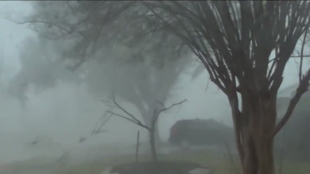
Houston tornado: Family trapped in SUV as tornado rips through Pasadena
A Pearland, Texas family spoke out after they were trapped inside their car in the middle of a tornado, and they caught the frightening moments on camera.
A Pearland, Texas family spoke out after they were trapped inside their car in the middle of a tornado, and they caught the frightening moments on camera.


Monday morning Houston-area weather forecast
The cold front that brought showers and downpours on Sunday stalled along the coast and will keep rain in the forecast for the start of the work week. Monday looks dreary and cool as colder air continues to move into Southeast Texas. Another front arrives on Thursday with the possibility of stronger storms when it arrives to Houston.
The cold front that brought showers and downpours on Sunday stalled along the coast and will keep rain in the forecast for the start of the work week. Monday looks dreary and cool as colder air continues to move into Southeast Texas. Another front arrives on Thursday with the possibility of stronger storms when it arrives to Houston.


Sunday evening Houston-weather forecast
The cold front that brought showers and downpours on Sunday stalled along the coast and will keep rain in the forecast for the start of the work week. Monday looks dreary and cool as colder air continues to move into Southeast Texas. Another front arrives on Thursday with the possibility of stronger storms when it arrives to Houston.
The cold front that brought showers and downpours on Sunday stalled along the coast and will keep rain in the forecast for the start of the work week. Monday looks dreary and cool as colder air continues to move into Southeast Texas. Another front arrives on Thursday with the possibility of stronger storms when it arrives to Houston.


Flood Advisory issued for the Houston area, several cities impacted
The National Weather Service issued a flood advisory for the Houston area until 2:30 pm on Sunday.
The National Weather Service issued a flood advisory for the Houston area until 2:30 pm on Sunday.


Sunday marks anniversary for the only time measurable snow fell in world's hottest place
Sunday marks the anniversary of the only time measurable snow fell in the hottest place in the world.
Sunday marks the anniversary of the only time measurable snow fell in the hottest place in the world.


El Tiempo 29 de enero de 2023
#FOX26 Meteor?loga Lena Maria Arango tiene su pron?stico para la semana laboral.
#FOX26 Meteor?loga Lena Maria Arango tiene su pron?stico para la semana laboral.


Transition into El Nino could lead to record heat around globe
Fishermen first used the term El Niño off the coast of South America to describe the unusually warm water temperatures before Christmas.
Fishermen first used the term El Niño off the coast of South America to describe the unusually warm water temperatures before Christmas.


Houston weather: Heavy rainfall, possible severe storms expected for Sunday
While today is not a repeat of Tuesday, locally heavy rainfall and strong to severe storms are possible. The front makes it to the coast, but stalls leading to periods of rain all week. Monday will be cloudy, drizzly and chilly with temperatures likely falling throughout the day as northwest winds take over. Rain chances then build again as we make our way toward our next front on Thursday. Post-frontal weather looks fantastic for the weekend, with sunshine returning.
While today is not a repeat of Tuesday, locally heavy rainfall and strong to severe storms are possible. The front makes it to the coast, but stalls leading to periods of rain all week. Monday will be cloudy, drizzly and chilly with temperatures likely falling throughout the day as northwest winds take over. Rain chances then build again as we make our way toward our next front on Thursday. Post-frontal weather looks fantastic for the weekend, with sunshine returning.


Deer Park residents prepare for incoming weather as FEMA begins survey of storm damage
Predicted storms throughout the coming days are threatening cleanup efforts in Deer Park and Pasadena.
Predicted storms throughout the coming days are threatening cleanup efforts in Deer Park and Pasadena.


Houston weather: Rainy pattern in Southeast Texas
Tomorrow starts a rainy pattern that will be around Southeast Texas for several days. Sunday will see rounds of heavy rain during most of the day with some stronger storms moving through with a front in the afternoon. That front stalls and keep rain in the forecast. Everyday won't be a washout, but some days will see heavy downpours mixed in with showers.
Tomorrow starts a rainy pattern that will be around Southeast Texas for several days. Sunday will see rounds of heavy rain during most of the day with some stronger storms moving through with a front in the afternoon. That front stalls and keep rain in the forecast. Everyday won't be a washout, but some days will see heavy downpours mixed in with showers.

How common are tornado outbreaks in southeast Texas?
As we wrap up an active weather week, with a historic tornado outbreak, you may be wondering, how often does something like this occur in southeast Texas?
As we wrap up an active weather week, with a historic tornado outbreak, you may be wondering, how often does something like this occur in southeast Texas?


Hawaii firefighter swept away in storm drain as heavy rains drench Maui
The firefighter was listed in critical condition.
The firefighter was listed in critical condition.


Saturday morning weather forecast with Meteorologist Lena Maria Arango
Saturday will feature light, scattered showers mainly in the first half of the day with a lull in activity in the afternoon/evening. Early Sunday morning, rain returns with more potency, with several pushes of locally heavy rain and the potential for strong to severe storms through the afternoon. That front then stalls, keeping us unsettled through at least Thursday. Several days of rain could lead to issues from time to time, so allow for plenty of extra time to navigate the roadways this week and stick with us for updates.
Saturday will feature light, scattered showers mainly in the first half of the day with a lull in activity in the afternoon/evening. Early Sunday morning, rain returns with more potency, with several pushes of locally heavy rain and the potential for strong to severe storms through the afternoon. That front then stalls, keeping us unsettled through at least Thursday. Several days of rain could lead to issues from time to time, so allow for plenty of extra time to navigate the roadways this week and stick with us for updates.


Saturday morning Houston-area weather forecast
We are in the process of transitioning into a cloudy, wet and at times stormy weather pattern. Stay alert over the weekend with the increased risk for flooding, especially Sunday. Tonight will still be cool with a few showers moving in. Rain increases for Saturday along with warmer temperatures near 70. Sunday as a front approaches, heavy downpours will become more likely along with a few strong storms. We are in a Category 1 out of 5 Marginal Risk for severe weather Sunday with isolated damaging wind gusts possible. There's also a higher threat for excessive rain which means flood threat will increase. I expect 1-3" of rain this weekend. More waves of rain will continue Monday through Wednesday. Showers should finally wind down late Thursday as cooler air moves in.
We are in the process of transitioning into a cloudy, wet and at times stormy weather pattern. Stay alert over the weekend with the increased risk for flooding, especially Sunday. Tonight will still be cool with a few showers moving in. Rain increases for Saturday along with warmer temperatures near 70. Sunday as a front approaches, heavy downpours will become more likely along with a few strong storms. We are in a Category 1 out of 5 Marginal Risk for severe weather Sunday with isolated damaging wind gusts possible. There's also a higher threat for excessive rain which means flood threat will increase. I expect 1-3" of rain this weekend. More waves of rain will continue Monday through Wednesday. Showers should finally wind down late Thursday as cooler air moves in.


Cloudy, cool Friday evening in the 50s
We are in the process of transitioning into a cloudy, wet and at times stormy weather pattern. Stay alert over the weekend with the increased risk for flooding, especially Sunday. Tonight will still be cool with a few showers moving in. Rain increases for Saturday along with warmer temperatures near 70. Sunday as a front approaches, heavy downpours will become more likely along with a few strong storms. We are in a Category 1 out of 5 Marginal Risk for severe weather Sunday with isolated damaging wind gusts possible. There's also a higher threat for excessive rain which means flood threat will increase. I expect 1-3" of rain this weekend. More waves of rain will continue Monday through Wednesday. Showers should finally wind down late Thursday as cooler air moves in.
We are in the process of transitioning into a cloudy, wet and at times stormy weather pattern. Stay alert over the weekend with the increased risk for flooding, especially Sunday. Tonight will still be cool with a few showers moving in. Rain increases for Saturday along with warmer temperatures near 70. Sunday as a front approaches, heavy downpours will become more likely along with a few strong storms. We are in a Category 1 out of 5 Marginal Risk for severe weather Sunday with isolated damaging wind gusts possible. There's also a higher threat for excessive rain which means flood threat will increase. I expect 1-3" of rain this weekend. More waves of rain will continue Monday through Wednesday. Showers should finally wind down late Thursday as cooler air moves in.