


Watching 5 disturbances in the Atlantic | FOX 26 Tropical Weather Forecast
The National Hurricane Center is watching a whopping five disturbances in the Atlantic basin with the chance for tropical development. One broad area of low pressure along a weak front in the northern Gulf has a 10% chance for tropical development. It will continue to spread more downpours along parts of the Gulf coast. Another disturbance in the western Caribbean has a low 20% chance to become a tropical system in the SW Gulf over the next week. Two other systems are being monitored in the Atlantic with a slim 10-20% chance for survival. Invest 99-L in NW Atlantic now has a 30% shot to become a brief tropical or subtropical system before moving into cooler waters this weekend.
The National Hurricane Center is watching a whopping five disturbances in the Atlantic basin with the chance for tropical development. One broad area of low pressure along a weak front in the northern Gulf has a 10% chance for tropical development. It will continue to spread more downpours along parts of the Gulf coast. Another disturbance in the western Caribbean has a low 20% chance to become a tropical system in the SW Gulf over the next week. Two other systems are being monitored in the Atlantic with a slim 10-20% chance for survival. Invest 99-L in NW Atlantic now has a 30% shot to become a brief tropical or subtropical system before moving into cooler waters this weekend.

Long-term weather trends with 'Captain' Bill Kirk
'Captain' Bill Kirk, CEO of Weather 360, joins Forecasting with Friends to talk about long-term weather trends for the area!
'Captain' Bill Kirk, CEO of Weather 360, joins Forecasting with Friends to talk about long-term weather trends for the area!

FOX 26 Houston Weather Forecast
Scattered shower will once again begin along the coast and slowly push inland later today. There is a Flood Watch along our coastal counties until Friday morning. A cold front is set to sweet across Southeast Texas Friday. This front will usher in lower humidity and cooler mornings. No rain is in the forecast this weekend so get out and enjoy!
Scattered shower will once again begin along the coast and slowly push inland later today. There is a Flood Watch along our coastal counties until Friday morning. A cold front is set to sweet across Southeast Texas Friday. This front will usher in lower humidity and cooler mornings. No rain is in the forecast this weekend so get out and enjoy!

Soggy Thursday on the way | FOX 26 Houston Weather Forecast
Bursts of heavy rain are possible this evening through early Friday as a lot of moisture and a front impact the area. Highest flood risk will likely be closer to the coast but a few flooded streets could pop up around Houston Thursday. Houston and Galveston remain in a 2 out of 4 slight risk for flooding Thursday. Flood Watch remains in place for Chambers, Galveston, Jackson, Brazoria & Matagorda counties until 7am Friday. Cold front will sweep away the rain and bring pleasant mornings and lower humidity this weekend through early next week. Enjoy!
Bursts of heavy rain are possible this evening through early Friday as a lot of moisture and a front impact the area. Highest flood risk will likely be closer to the coast but a few flooded streets could pop up around Houston Thursday. Houston and Galveston remain in a 2 out of 4 slight risk for flooding Thursday. Flood Watch remains in place for Chambers, Galveston, Jackson, Brazoria & Matagorda counties until 7am Friday. Cold front will sweep away the rain and bring pleasant mornings and lower humidity this weekend through early next week. Enjoy!

FOX 26 Houston Weather Forecast
Bursts of heavy rain are possible this evening through early Friday as a lot of moisture and a front impact the area. Highest flood risk will likely be closer to the coast but a few flooded streets could pop up around Houston Thursday. Houston and Galveston remain in a 2 out of 4 slight risk for flooding Thursday. Flood Watch remains in place for Chambers, Galveston, Jackson, Brazoria & Matagorda counties until 7am Friday. Cold front will sweep away the rain and bring pleasant mornings and lower humidity this weekend through early next week. Enjoy!
Bursts of heavy rain are possible this evening through early Friday as a lot of moisture and a front impact the area. Highest flood risk will likely be closer to the coast but a few flooded streets could pop up around Houston Thursday. Houston and Galveston remain in a 2 out of 4 slight risk for flooding Thursday. Flood Watch remains in place for Chambers, Galveston, Jackson, Brazoria & Matagorda counties until 7am Friday. Cold front will sweep away the rain and bring pleasant mornings and lower humidity this weekend through early next week. Enjoy!

Watching tropical waves for possible development in Atlantic
National hurricane center is now monitoring four disturbances with a low chance for tropical development. Newest area being monitored is a few hundred miles east of North Carolina and disorganized. It's moving NE away from the United States and has a low 10-20% chance of briefly becoming subtropical. Tropical wave in the central Caribbean still has a 30% chance of development over the next week and is forecast to reach the SW Gulf of Mexico by this weekend. It should stay south of the Houston area with a cold front keeping it south. Two other tropical waves are being monitored in the Atlantic with a low chance for some slow development over the next seven days.
National hurricane center is now monitoring four disturbances with a low chance for tropical development. Newest area being monitored is a few hundred miles east of North Carolina and disorganized. It's moving NE away from the United States and has a low 10-20% chance of briefly becoming subtropical. Tropical wave in the central Caribbean still has a 30% chance of development over the next week and is forecast to reach the SW Gulf of Mexico by this weekend. It should stay south of the Houston area with a cold front keeping it south. Two other tropical waves are being monitored in the Atlantic with a low chance for some slow development over the next seven days.

Why experts predict a quiet September | Forecasting With Friends
Weather forecasting is always better with friends! This morning, our team dives into the latest on tropical storms and the surprising forecast for September.
Weather forecasting is always better with friends! This morning, our team dives into the latest on tropical storms and the surprising forecast for September.

More rain possible Wednesday | FOX 26 Houston Weather Forecast
Look for a few more rainy days as moisture lingers and a weak front enhances rain chances. Threat for street flooding shifts back to the north over Houston Wednesday with more widespread rain also expected Thursday. Cold front will enhance rain chances the next few days but will bring in much drier air for your weekend plans. Pleasant mornings and lower humidity are in store early next week. Enjoy it!
Look for a few more rainy days as moisture lingers and a weak front enhances rain chances. Threat for street flooding shifts back to the north over Houston Wednesday with more widespread rain also expected Thursday. Cold front will enhance rain chances the next few days but will bring in much drier air for your weekend plans. Pleasant mornings and lower humidity are in store early next week. Enjoy it!

Continuing to monitor tropical waves in Atlantic | FOX 26 Tropical Weather Forecast
In the Atlantic, no named storms have formed since Ernesto on August 12th. This has been a pretty remarkable quiet period for hurricane activity. But don't let your guard down as September is historically the busiest month of hurricane season. We are monitoring three tropical waves in the Atlantic basin. One in the Central Caribbean has a low 30% chance of development over the next seven days. There are also two tropical waves in the central and eastern Atlantic. Both only have a low chance to become a tropical system but will be watched closely.
In the Atlantic, no named storms have formed since Ernesto on August 12th. This has been a pretty remarkable quiet period for hurricane activity. But don't let your guard down as September is historically the busiest month of hurricane season. We are monitoring three tropical waves in the Atlantic basin. One in the Central Caribbean has a low 30% chance of development over the next seven days. There are also two tropical waves in the central and eastern Atlantic. Both only have a low chance to become a tropical system but will be watched closely.

Summer cold front| Fox 26 Houston Weather Forecast
Following flooding bear the beaches on Labor Day, today we'll continue a similar pattern with heavy rain south of Houston and more spotty storms closer to town and surrounding suburbs. Look for humid highs in the low 90s. Rain chances will actually rise for Wednesday and especially Thursday, but then...a summer "cold" front! The main change we expect is that the humidity will drop by Saturday and lows could even drop into the upper 60s in spots by Sunday and Monday morning. Surprisingly, there is very little activity in the tropics, but there is a chance for a low to develop and affect the Yucatan later this week. Otherwise, we're in good shape for now.
Following flooding bear the beaches on Labor Day, today we'll continue a similar pattern with heavy rain south of Houston and more spotty storms closer to town and surrounding suburbs. Look for humid highs in the low 90s. Rain chances will actually rise for Wednesday and especially Thursday, but then...a summer "cold" front! The main change we expect is that the humidity will drop by Saturday and lows could even drop into the upper 60s in spots by Sunday and Monday morning. Surprisingly, there is very little activity in the tropics, but there is a chance for a low to develop and affect the Yucatan later this week. Otherwise, we're in good shape for now.
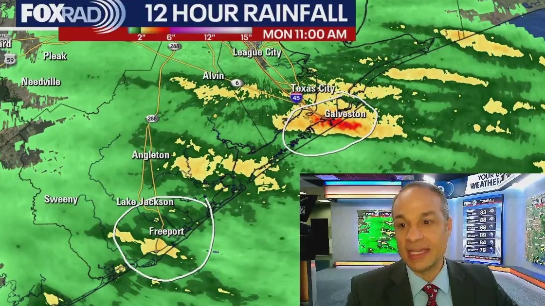
Rain continues into Tuesday | FOX 26 Houston Weather Forecast
The threat for more heavy downpours and flooding will continue for a few more days, especially around Galveston, Lake Jackson, Angleton & Bay City. Low pressure near coast is not expected to turn into a tropical system since it will move over land by tomorrow morning. But this disturbance combined with a weak cold front will keep decent rain chances in the forecast through Thursday. Behind the late summer cold front, expect a refreshing pattern change that will include brighter skies, lower humidity and drier weather!
The threat for more heavy downpours and flooding will continue for a few more days, especially around Galveston, Lake Jackson, Angleton & Bay City. Low pressure near coast is not expected to turn into a tropical system since it will move over land by tomorrow morning. But this disturbance combined with a weak cold front will keep decent rain chances in the forecast through Thursday. Behind the late summer cold front, expect a refreshing pattern change that will include brighter skies, lower humidity and drier weather!
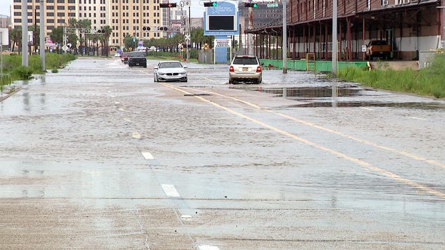

Labor Day washout on Galveston Island
Galveston's typically bustling Labor Day was dampened by heavy rain, resulting in desolation and safety concerns on the beaches. Nonetheless, a handful of resilient visitors made the best of the stormy holiday.
Galveston's typically bustling Labor Day was dampened by heavy rain, resulting in desolation and safety concerns on the beaches. Nonetheless, a handful of resilient visitors made the best of the stormy holiday.

Monitoring two areas of disturbed weather in Atlantic | FOX 26 Houston Tropical Weather Update
We are now officially in what is typically the busiest month of hurricane season! There's some good news though. Disturbance in the NW Gulf of Mexico near Houston should move over land early Tuesday which ends the chance of tropical formation. However there are two other tropical waves with a MEDIUM 40% chance of development. One is in the Eastern Caribbean and could make it into the SW Gulf by this weekend. The other is still far out in the Eastern Atlantic which gives us several days to watch it. The next two names on the list are Francine and Gordon. The peak of hurricane season is September 10.
We are now officially in what is typically the busiest month of hurricane season! There's some good news though. Disturbance in the NW Gulf of Mexico near Houston should move over land early Tuesday which ends the chance of tropical formation. However there are two other tropical waves with a MEDIUM 40% chance of development. One is in the Eastern Caribbean and could make it into the SW Gulf by this weekend. The other is still far out in the Eastern Atlantic which gives us several days to watch it. The next two names on the list are Francine and Gordon. The peak of hurricane season is September 10.
Possible hurricane | Mondays With Mike
Get the latest on training storms, a possible hurricane, and a surprise summer cool front with Mondays with Mike!
Get the latest on training storms, a possible hurricane, and a surprise summer cool front with Mondays with Mike!

Hurricane Gear Test: Uncharted Supply Co. The Zeus Air
Power banks are a must-have during emergencies, especially when the lights go out. But what if your power bank could do more than just charge your phone?
Power banks are a must-have during emergencies, especially when the lights go out. But what if your power bank could do more than just charge your phone?

Scattered storms & rip currents | Fox 26 Houston Weather Forecast
Happy Labor Day, everyone. We hope you have a relaxing one, but there will be some showers and storms to dodge. If you have beach plans today, just be cautious and check your Fox 26 weather app because there is a high chance for storms and even some isolated street flooding. In between storms it will be breezy with an onshore wind, so rip currents will be possible. Be careful. For the rest of the week, expect scattered showers and storms on Tuesday with a higher rain chance Wednesday and early Thursday. By the end of the week, guess what...a summer cold front? It looks like a front will pass through by Friday bringing slightly drier air. Days will still be warm, but morning lows should be about 5-10 degrees cooler. As far as tropical activity, a small area of low pressure will meander around our coastline for the next few days before the front comes through and it's chances for becoming a depression are low. Elsewhere, we'll watch for a possible system in the Caribbean or Gulf in about 10-12 days, but all that is highly uncertain.
Happy Labor Day, everyone. We hope you have a relaxing one, but there will be some showers and storms to dodge. If you have beach plans today, just be cautious and check your Fox 26 weather app because there is a high chance for storms and even some isolated street flooding. In between storms it will be breezy with an onshore wind, so rip currents will be possible. Be careful. For the rest of the week, expect scattered showers and storms on Tuesday with a higher rain chance Wednesday and early Thursday. By the end of the week, guess what...a summer cold front? It looks like a front will pass through by Friday bringing slightly drier air. Days will still be warm, but morning lows should be about 5-10 degrees cooler. As far as tropical activity, a small area of low pressure will meander around our coastline for the next few days before the front comes through and it's chances for becoming a depression are low. Elsewhere, we'll watch for a possible system in the Caribbean or Gulf in about 10-12 days, but all that is highly uncertain.

Low pressure brings rain | Tropical weather update
The broad area of low pressure off the Texas coast is looking less likely to become something tropical, but it will still be a rainmaker for the Gulf Coast over the next several days. The tropical wave in the Atlantic heading into the Caribbean this week continues to be very slow in signs of developing. The forecast confidence with this system is low, so let's keep watching it closely this week.
The broad area of low pressure off the Texas coast is looking less likely to become something tropical, but it will still be a rainmaker for the Gulf Coast over the next several days. The tropical wave in the Atlantic heading into the Caribbean this week continues to be very slow in signs of developing. The forecast confidence with this system is low, so let's keep watching it closely this week.

Labor Day washout? | Fox 26 Houston Weather Forecast
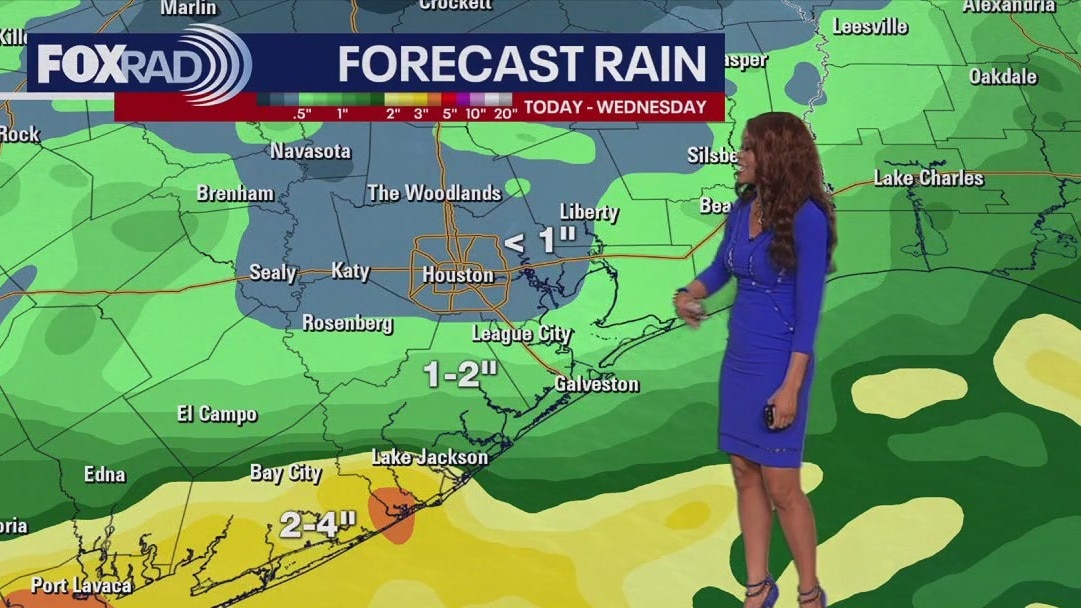
Scattered showers will continue today across SE Texas. An area of low pressure meandering off our coast is aiding in several rounds of rain not just through the holiday weekend, but continuing into next week. Isolated flooding is possible along the coast. With high rain chances and cloud cover comes slightly cooler temperatures. Highs will reach the upper 80s today. Keep and umbrella handy this Labor Day Weekend and download the FOX 26 weather app.
Scattered showers will continue today across SE Texas. An area of low pressure meandering off our coast is aiding in several rounds of rain not just through the holiday weekend, but continuing into next week. Isolated flooding is possible along the coast. With high rain chances and cloud cover comes slightly cooler temperatures. Highs will reach the upper 80s today. Keep and umbrella handy this Labor Day Weekend and download the FOX 26 weather app.

FOX 26 Houston Weather Forecast
The area of low pressure sitting off the Texas coast is getting a lot of attention this holiday weekend. It will be creating high possibilities for rain and perhaps even some areas of flooding right along the coast. The National Hurricane Center is also interested in this disturbed weather. They will continue to monitor for tropical development but expectations there are pretty low. The is a chance for several inches of rain in total through the next week as this system meanders back and forth along the coast for Beaumont to Corpus Christi. Keep this unsettled pattern in mind as you make your plans for Labor Day on Monday.
The area of low pressure sitting off the Texas coast is getting a lot of attention this holiday weekend. It will be creating high possibilities for rain and perhaps even some areas of flooding right along the coast. The National Hurricane Center is also interested in this disturbed weather. They will continue to monitor for tropical development but expectations there are pretty low. The is a chance for several inches of rain in total through the next week as this system meanders back and forth along the coast for Beaumont to Corpus Christi. Keep this unsettled pattern in mind as you make your plans for Labor Day on Monday.

Tropical update: Area of low pressure in Gulf
The National Hurricane Center is still watching a broad area of low pressure off the Texas coast. Tropical development is not expected but also not impossible. It will definitely bring rain along much of the Gulf coast this holiday weekend. More concerning for tropical development lies in a tropical wave out in the Atlantic headed towards the Caribbean.
The National Hurricane Center is still watching a broad area of low pressure off the Texas coast. Tropical development is not expected but also not impossible. It will definitely bring rain along much of the Gulf coast this holiday weekend. More concerning for tropical development lies in a tropical wave out in the Atlantic headed towards the Caribbean.