


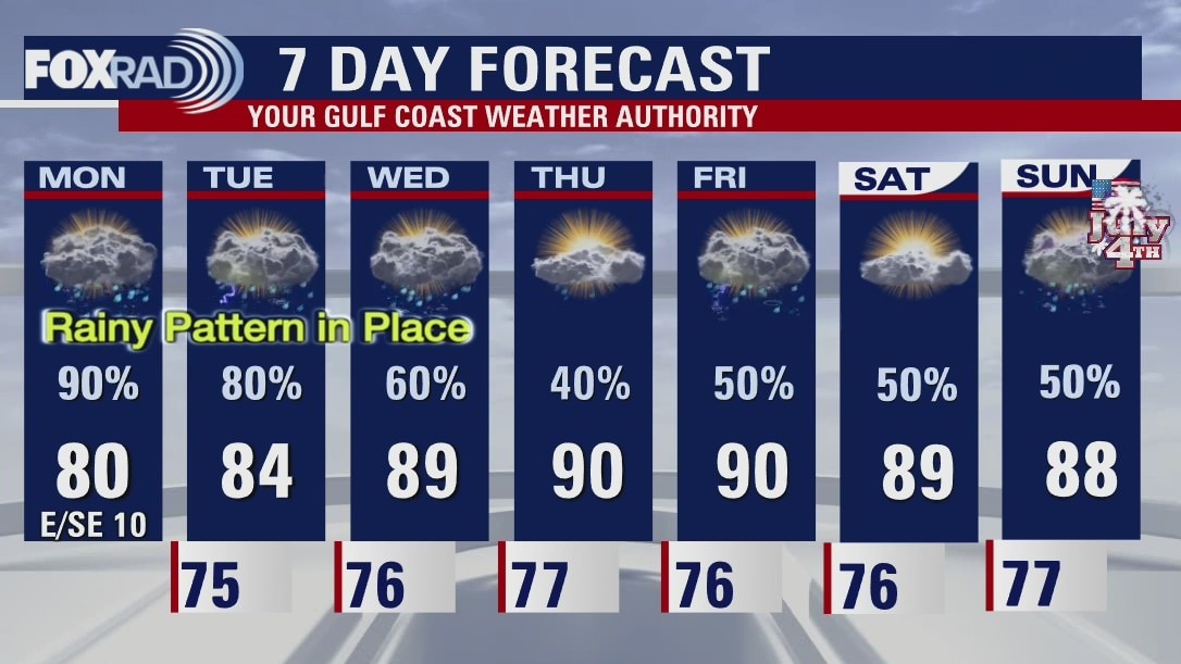
Monday evening weather forecast
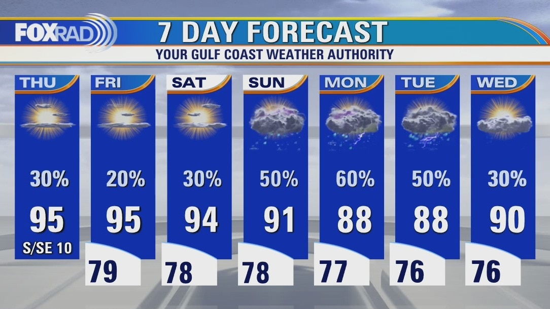
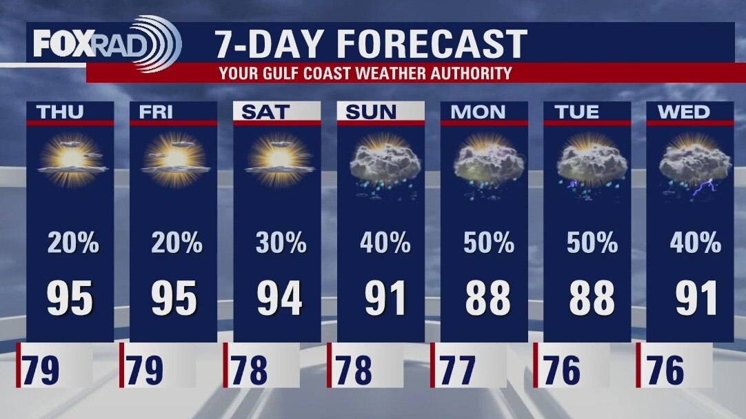
Rain stays in the forecast for most of this week and into the holiday weekend. Look for more downpours on Tuesday as rounds of rain will continue to move through the Houston area. It's not time to cancel outdoor plans yet, but you may need to start considering some indoor options for the July 4th Celebrations.
Rain stays in the forecast for most of this week and into the holiday weekend. Look for more downpours on Tuesday as rounds of rain will continue to move through the Houston area. It's not time to cancel outdoor plans yet, but you may need to start considering some indoor options for the July 4th Celebrations.
Monday weather forecast
Waves of heavy rain will move through our area today and tomorrow with scattered storms expected for the rest of the week.
Waves of heavy rain will move through our area today and tomorrow with scattered storms expected for the rest of the week.
Monday weather forecast
Waves of heavy rain will move through our area today and tomorrow with scattered storms expected for the rest of the week. Street flooding is very likely in spots and we've already had advisories in Fort Bend and Brazoria this morning, so drive carefully. One good effect of the rain will be temperatures that are below normal.
Waves of heavy rain will move through our area today and tomorrow with scattered storms expected for the rest of the week. Street flooding is very likely in spots and we've already had advisories in Fort Bend and Brazoria this morning, so drive carefully. One good effect of the rain will be temperatures that are below normal.
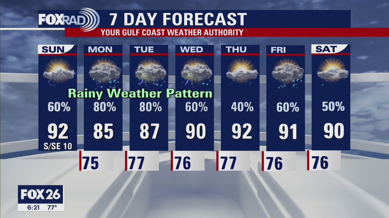
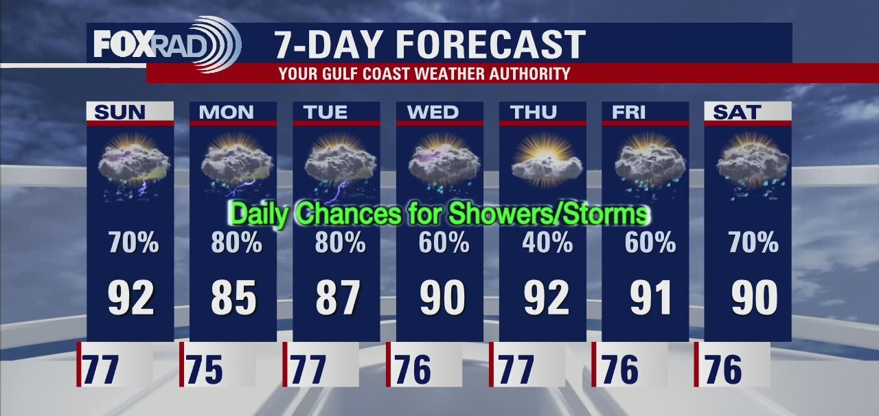
Rainy week ahead for most of southeast Texas.
Meteorologist Collin Myers says the showers and thunderstorms we saw today are just the start of an active week. Expect heavy downpours and thunderstorms for your Monday and again on Tuesday. Chances continue for most of the week, and some could be briefly heavy at times.
Meteorologist Collin Myers says the showers and thunderstorms we saw today are just the start of an active week. Expect heavy downpours and thunderstorms for your Monday and again on Tuesday. Chances continue for most of the week, and some could be briefly heavy at times.
Houston-area weather forecast: June 27th
Showers looking more likely today as an upper level disturbances moves a little closer to southeast Texas. While it's not going to be raining all day, those chances will remain high throughout the afternoon. Our best rain chances still appear to be Monday and Tuesday. The heaviest of rain will likely fall along the coast, but flooding will not be a big concern. High temperatures today will reach the low 90s with cooler temperatures expected to kick off the work week.
Showers looking more likely today as an upper level disturbances moves a little closer to southeast Texas. While it's not going to be raining all day, those chances will remain high throughout the afternoon. Our best rain chances still appear to be Monday and Tuesday. The heaviest of rain will likely fall along the coast, but flooding will not be a big concern. High temperatures today will reach the low 90s with cooler temperatures expected to kick off the work week.
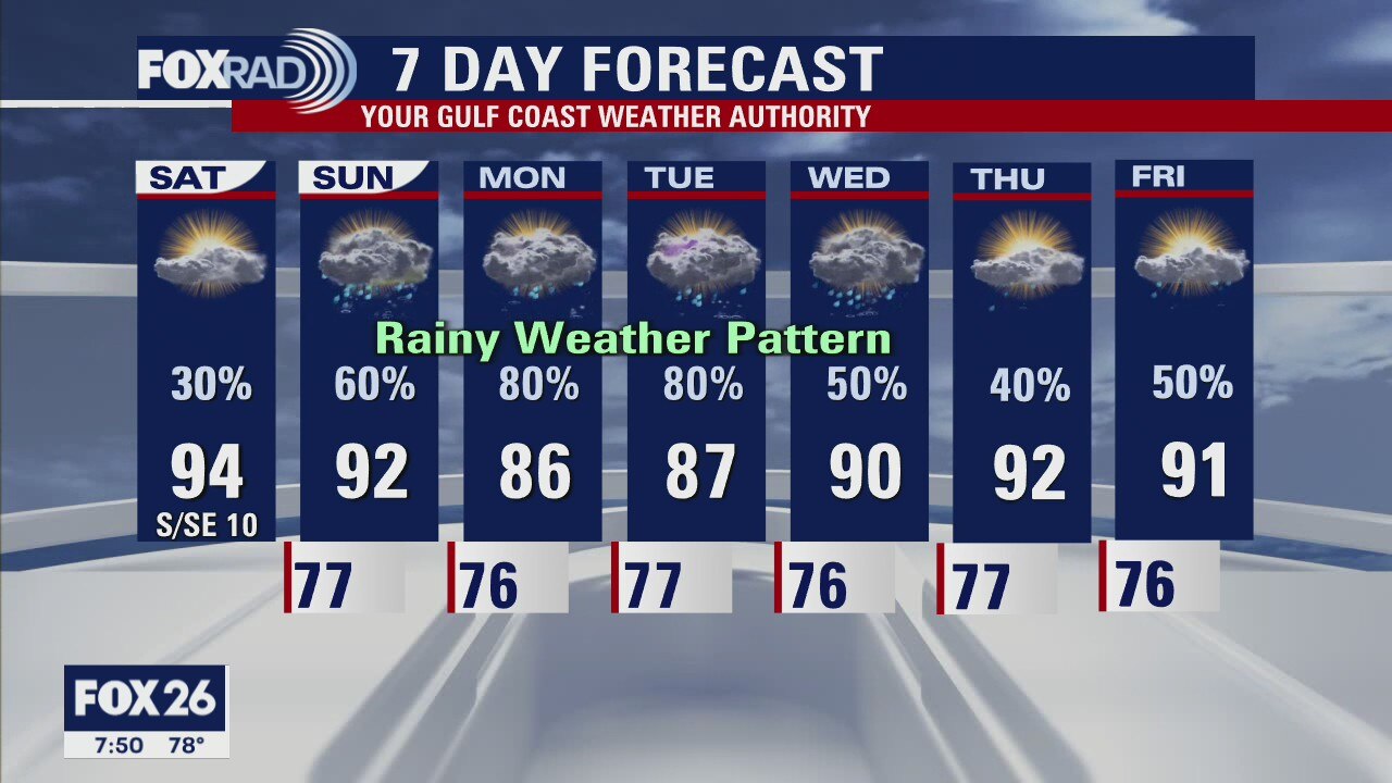
Saturday evening weather forecast with FOX 26 Meteorologist John Dawson
Houston will end the weekend with afternoon temperatures dropping below the seasonal averages because of plenty of clouds and possible showers. Deep tropical moisture moves into the region and keeps showers/thunderstorms in the forecast for most of the week ahead
Houston will end the weekend with afternoon temperatures dropping below the seasonal averages because of plenty of clouds and possible showers. Deep tropical moisture moves into the region and keeps showers/thunderstorms in the forecast for most of the week ahead
Houston-area weather forecast: June 26th
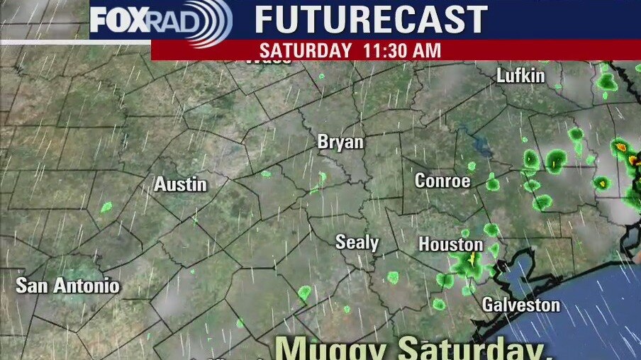
A steamy start to our Saturday with rain chances remaining on the slight side this afternoon. Highs will reach the low 90s for much of the area. Sunday is when our weather pattern begins to change a bit with rain and storms likely, especially along the coast. Those higher rain chances will continue into Monday and Tuesday with the heaviest rain expected to fall along the coast.
A steamy start to our Saturday with rain chances remaining on the slight side this afternoon. Highs will reach the low 90s for much of the area. Sunday is when our weather pattern begins to change a bit with rain and storms likely, especially along the coast. Those higher rain chances will continue into Monday and Tuesday with the heaviest rain expected to fall along the coast.
Saturday morning weather forecast
A rainy pattern is about to move into Southeast Texas but first one more warm and steamy day on Saturday. Houston will end the weekend with afternoon temperatures dropping below the seasonal averages because of plenty of clouds and possible showers. Deep tropical moisture moves into the region and keeps showers/thunderstorms in the forecast for most of the week ahead.
A rainy pattern is about to move into Southeast Texas but first one more warm and steamy day on Saturday. Houston will end the weekend with afternoon temperatures dropping below the seasonal averages because of plenty of clouds and possible showers. Deep tropical moisture moves into the region and keeps showers/thunderstorms in the forecast for most of the week ahead.

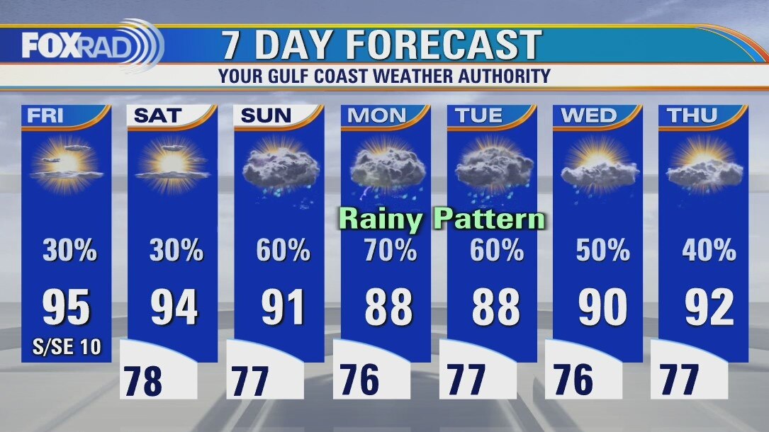
Friday Evening Weather Forecast
A rainy pattern is about to move into Southeast Texas but first one more warm and steamy day on Saturday. Houston will end the weekend with afternoon temperatures dropping below the seasonal averages because of plenty of clouds and possible showers. Deep tropical moisture moves into the region and keeps showers/thunderstorms in the forecast for most of the week ahead.
A rainy pattern is about to move into Southeast Texas but first one more warm and steamy day on Saturday. Houston will end the weekend with afternoon temperatures dropping below the seasonal averages because of plenty of clouds and possible showers. Deep tropical moisture moves into the region and keeps showers/thunderstorms in the forecast for most of the week ahead.
Friday weather forecast
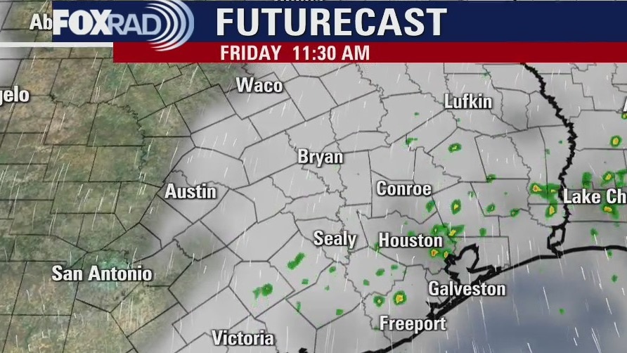
Partly cloudy with a few morning showers and isolated afternoon storms. Highs in the low to mid 90s.
Partly cloudy with a few morning showers and isolated afternoon storms. Highs in the low to mid 90s.
Friday morning weather forecast
Steamy and hot for the next couple day in Southeast Texas. Expect a few isolated storms popping up in the afternoons. Houston will start moving into a rainy weather pattern on Sunday. Look for several rounds of rain through at least the first half of the work week.
Steamy and hot for the next couple day in Southeast Texas. Expect a few isolated storms popping up in the afternoons. Houston will start moving into a rainy weather pattern on Sunday. Look for several rounds of rain through at least the first half of the work week.
Thursday Evening Weather Forecast
Steamy and hot for the next couple day in Southeast Texas. Expect a few isolated storms popping up in the afternoons. Houston will start moving into a rainy weather pattern on Sunday. Look for several rounds of rain through at least the first half of the work week.
Steamy and hot for the next couple day in Southeast Texas. Expect a few isolated storms popping up in the afternoons. Houston will start moving into a rainy weather pattern on Sunday. Look for several rounds of rain through at least the first half of the work week.
Thursday weather forecast
Temperatures this morning stayed above 80 in many spots and more warm nights and hot days lie ahead. Watch for isolated storms today through Saturday with an increase in clouds and rain coverage beginning Sunday. Daily heat index values could reach 105.
Temperatures this morning stayed above 80 in many spots and more warm nights and hot days lie ahead. Watch for isolated storms today through Saturday with an increase in clouds and rain coverage beginning Sunday. Daily heat index values could reach 105.
Thursday morning weather forecast
A typical summer forecast is in store for SE Texas and the Houston area. Highs will be in the 90s through the weekend and it will be very humid. Rain chances go up early next week and that will help to bring the temps down a few degrees.
A typical summer forecast is in store for SE Texas and the Houston area. Highs will be in the 90s through the weekend and it will be very humid. Rain chances go up early next week and that will help to bring the temps down a few degrees.
Wednesday Evening Weather Forecast
A typical summer forecast is in store for SE Texas and the Houston area. Highs will be in the 90s through the weekend and it will be very humid. Rain chances go up early next week and that will help to bring the temps down a few degrees.
A typical summer forecast is in store for SE Texas and the Houston area. Highs will be in the 90s through the weekend and it will be very humid. Rain chances go up early next week and that will help to bring the temps down a few degrees.
Wednesday weather forecast
A typical early summer pattern is in place with morning lows in the upper 70s and highs in the mid 90s along with a daily chance for hit and miss storms. Early next week, more cloud cover and showers look likely. The tropics remain quiet for now.
A typical early summer pattern is in place with morning lows in the upper 70s and highs in the mid 90s along with a daily chance for hit and miss storms. Early next week, more cloud cover and showers look likely. The tropics remain quiet for now.

Wednesday morning weather forecast
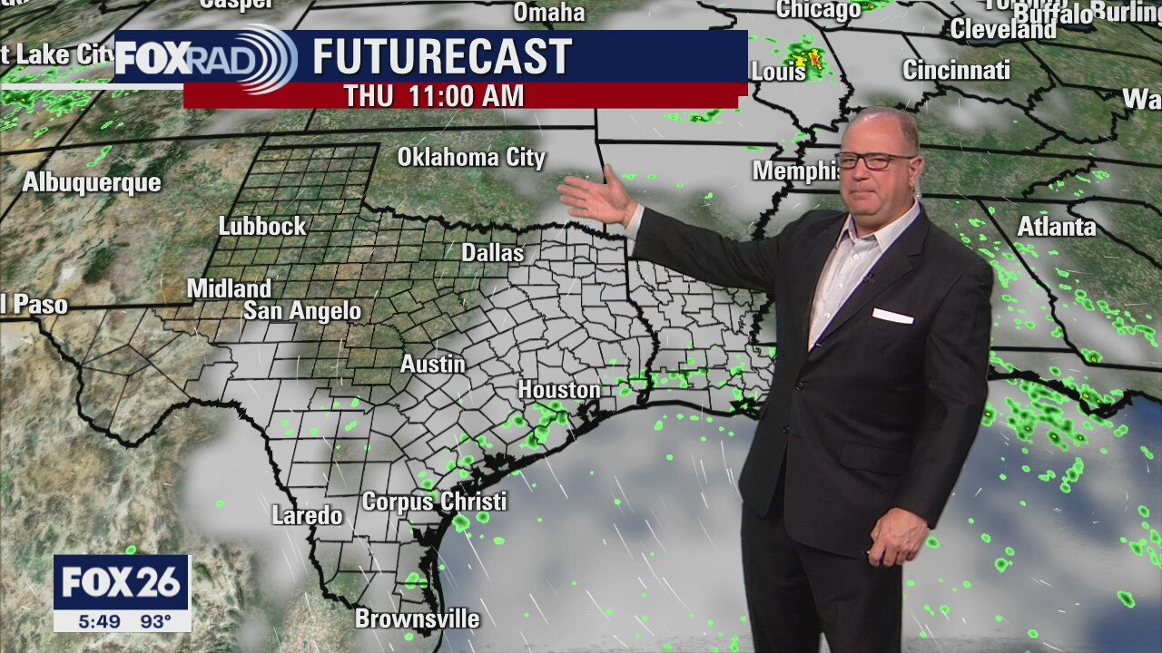
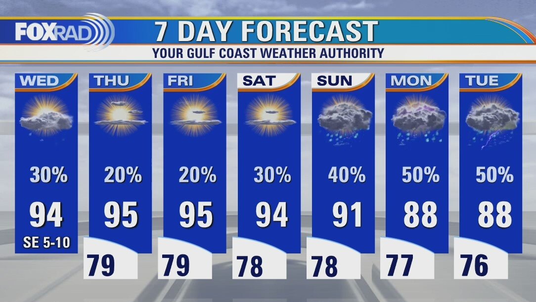
There will be less rain in the forecast, but there will still be a few pop-up showers mainly with the heating of the day. It gets a bit hotter by the end of the week with highs near 95 and heat index values near 106. It is officially summer and it?s going to feel like it. Look for more widespread showers starting on Sunday.
There will be less rain in the forecast, but there will still be a few pop-up showers mainly with the heating of the day. It gets a bit hotter by the end of the week with highs near 95 and heat index values near 106. It is officially summer and it?s going to feel like it. Look for more widespread showers starting on Sunday.
Tuesday Evening Weather Forecast
There will be less rain in the forecast, but there will still be a few pop-up showers mainly with the heating of the day. It gets a bit hotter by the end of the week with highs near 95 and heat index values near 106. It is officially summer and it?s going to feel like it. Look for more widespread showers starting on Sunday.
There will be less rain in the forecast, but there will still be a few pop-up showers mainly with the heating of the day. It gets a bit hotter by the end of the week with highs near 95 and heat index values near 106. It is officially summer and it?s going to feel like it. Look for more widespread showers starting on Sunday.

Tuesday weather forecast
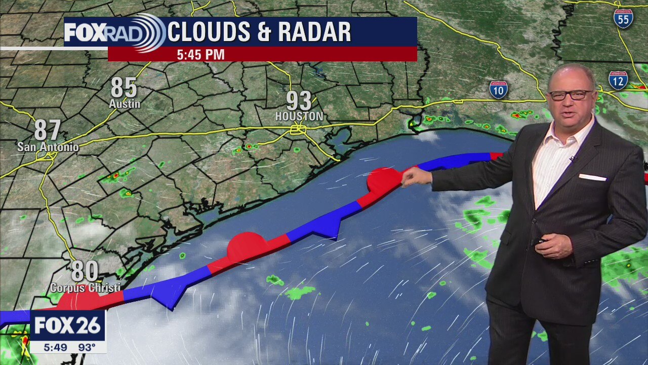
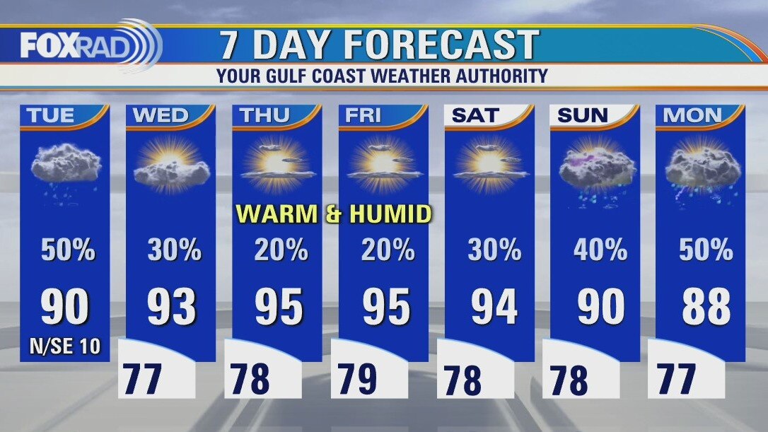
Following vicious early morning storms, the sun will warm us into the upper 80s and low 90s this afternoon. By late afternoon and evening, spotty storms could re-form. The trend for the rest of the week includes gradually lower rain chances and hotter afternoons.
Following vicious early morning storms, the sun will warm us into the upper 80s and low 90s this afternoon. By late afternoon and evening, spotty storms could re-form. The trend for the rest of the week includes gradually lower rain chances and hotter afternoons.
Tuesday weather forecast
Morning showers and storms, then warm and humid with isolated rain. Highs in the low 90s.
Morning showers and storms, then warm and humid with isolated rain. Highs in the low 90s.