


Hurricane Ida Update with Dr. Jim Siebert and John Dawson
Your Gulf Coast Weather Authority breaks down what you can expect from Hurricane Ida as it heads toward Louisiana.
Your Gulf Coast Weather Authority breaks down what you can expect from Hurricane Ida as it heads toward Louisiana.
Friday afternoon weather forecast with Meteorologist John Dawson
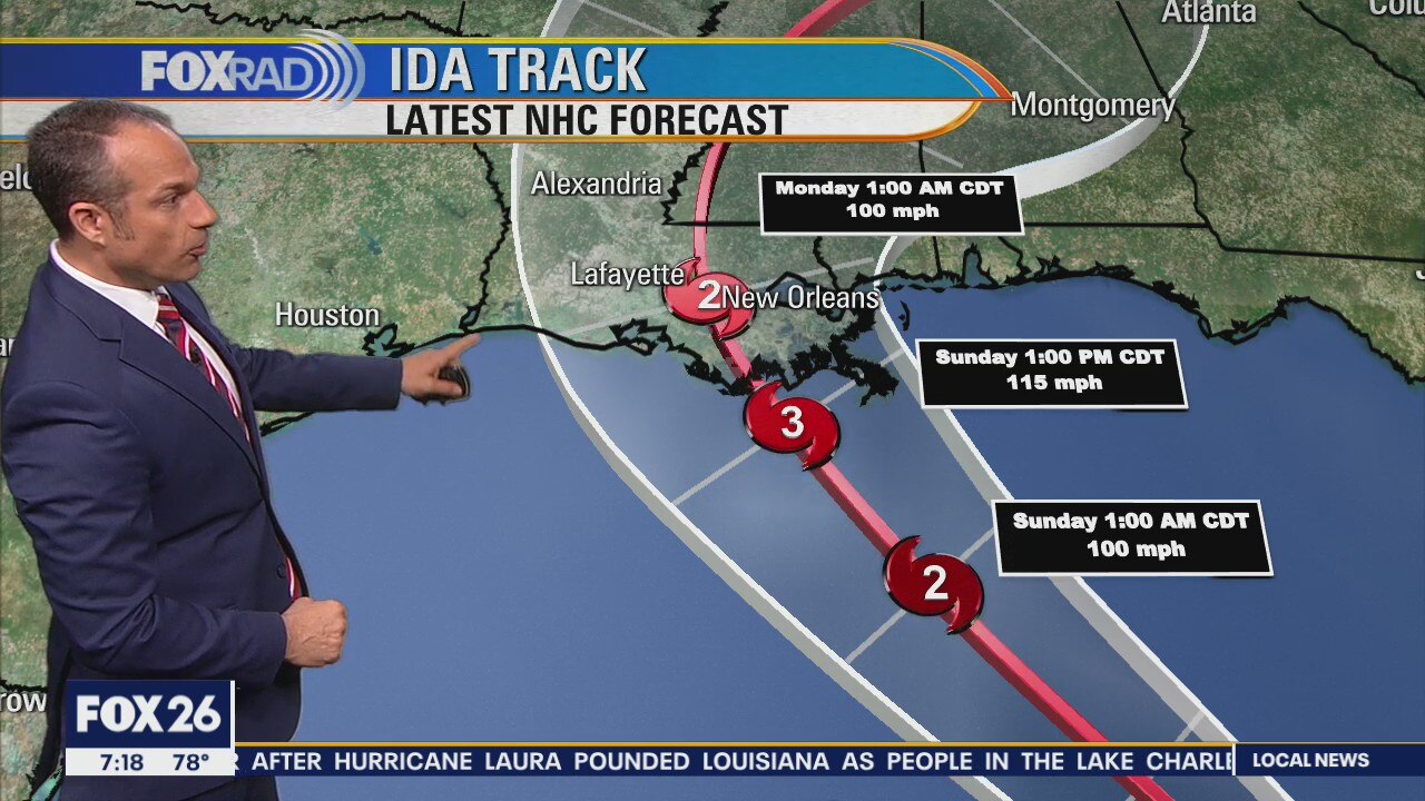
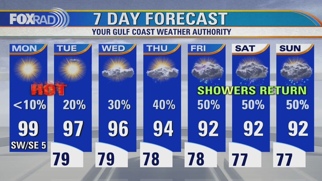
Ida is now at Cat. 1 hurricane with winds at 75mph. The storm will likely grow much stronger into a major hurricane once it enters the Gulf. Impacts will be minor for the Texas coast, but it will be very dangerous for our friends in Louisiana, Mississippi, and Alabama.
Ida is now at Cat. 1 hurricane with winds at 75mph. The storm will likely grow much stronger into a major hurricane once it enters the Gulf. Impacts will be minor for the Texas coast, but it will be very dangerous for our friends in Louisiana, Mississippi, and Alabama.
Showers and storms as we watch Ida
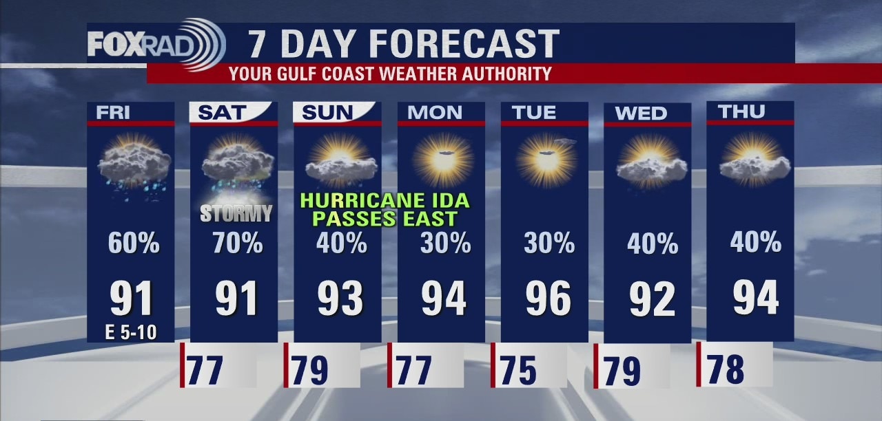
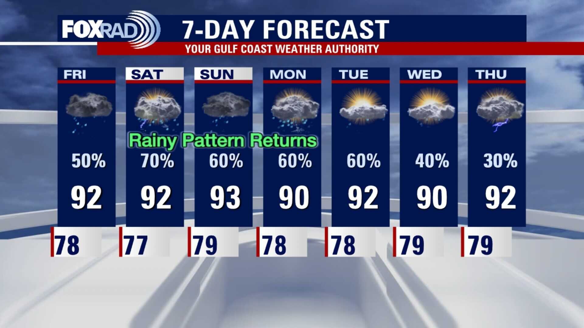
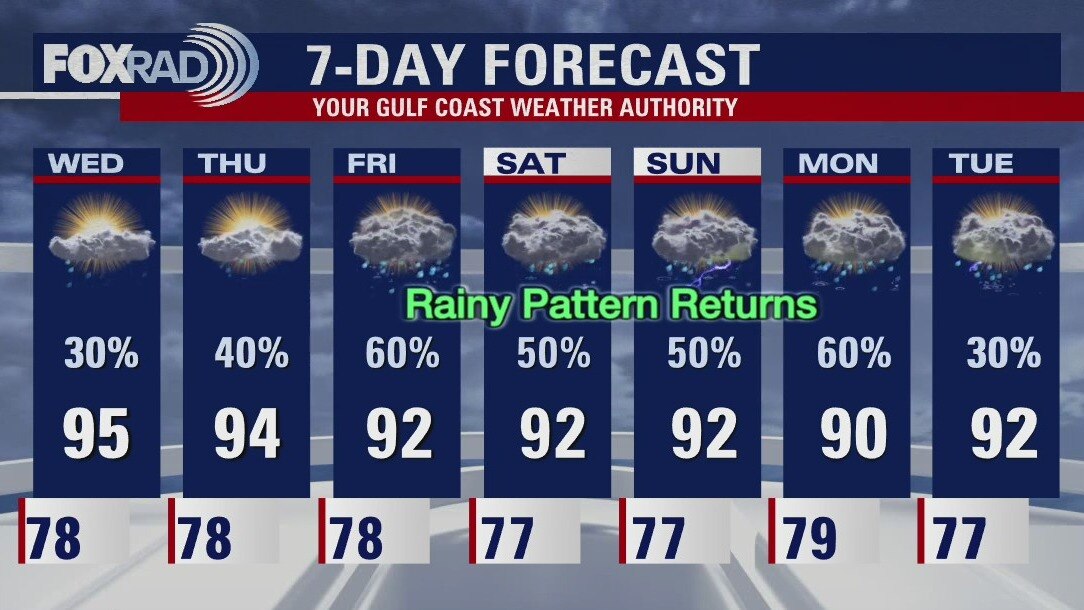
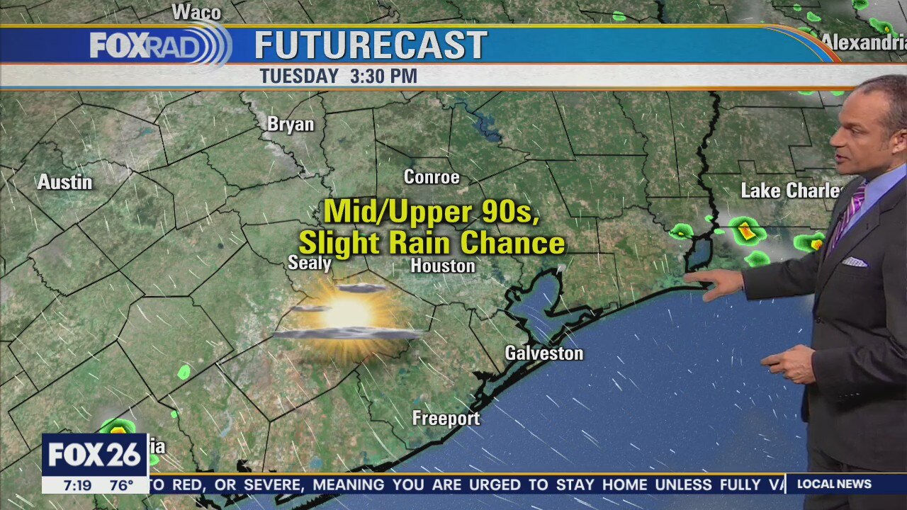
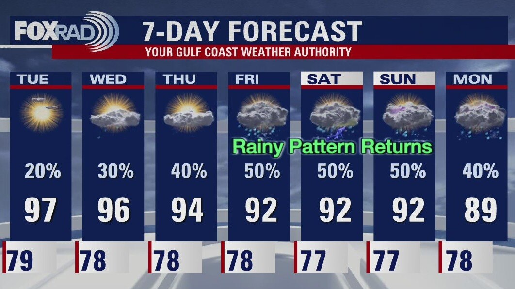
Tropical Storm Ida (soon to be a hurricane) is expected to pass well to our east into Louisiana on Sunday evening. With that path, we should expect minimal effects on our area other than high waves, rip currents and higher tides for coastal areas. Watch for showery weather south of Houston through midday today with isolated afternoon storms. More storms are likely for Saturday with hotter weather likely beginning Sunday as Ida passes to our east.
Tropical Storm Ida (soon to be a hurricane) is expected to pass well to our east into Louisiana on Sunday evening. With that path, we should expect minimal effects on our area other than high waves, rip currents and higher tides for coastal areas. Watch for showery weather south of Houston through midday today with isolated afternoon storms. More storms are likely for Saturday with hotter weather likely beginning Sunday as Ida passes to our east.
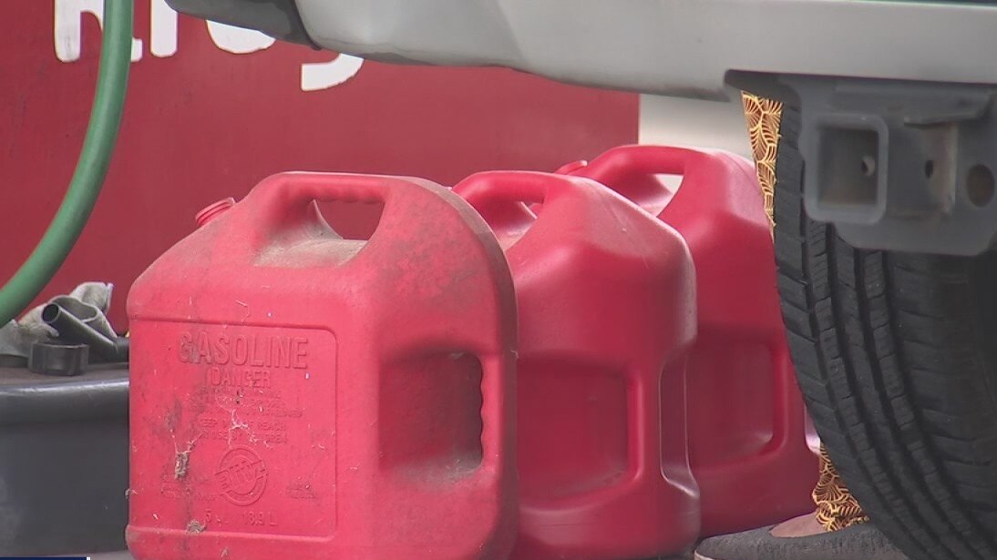
Orange residents preparing for possible arrival of TS Ida
FOX 26 Reporter Matthew Seedorff spoke with some residents who are preparing for the possible arrival of Tropical Storm Ida.
FOX 26 Reporter Matthew Seedorff spoke with some residents who are preparing for the possible arrival of Tropical Storm Ida.
Friday morning weather forecast
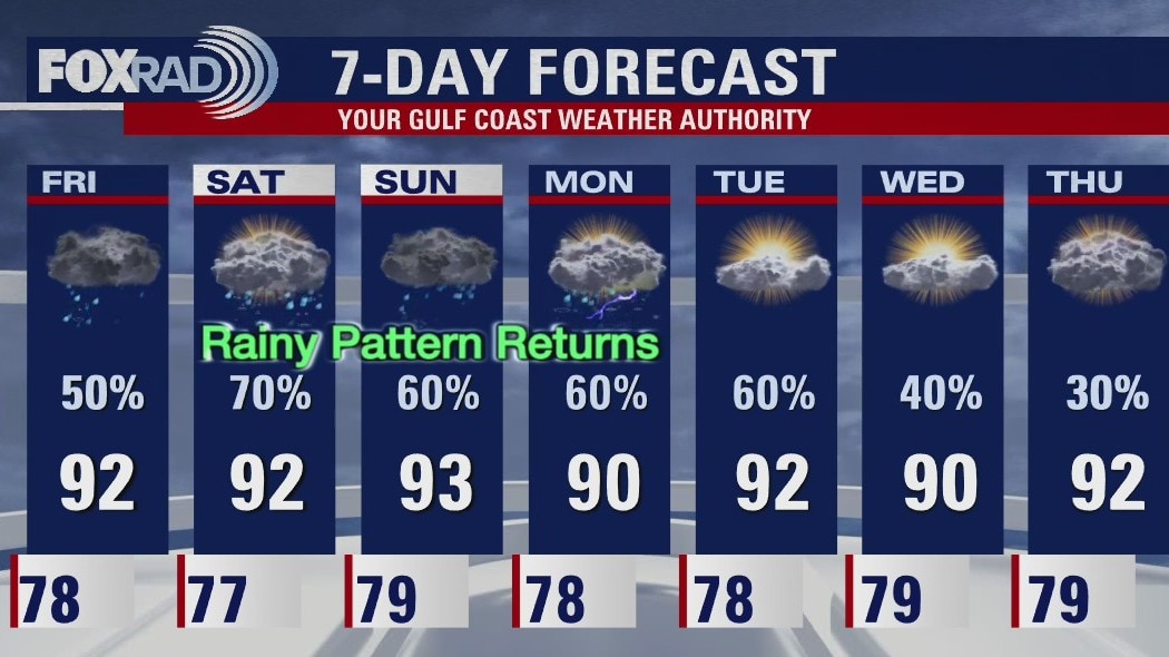
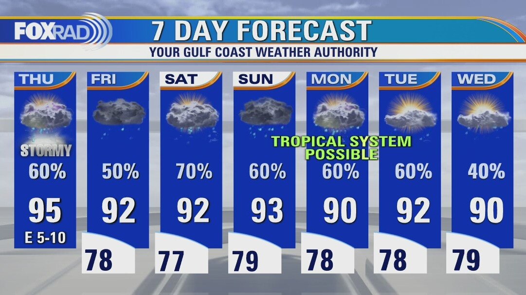
Rain will be more likely for the rest of the week, but it's unrelated to TS Ida. Extra moisture will be moving into the area and that will provide a wetter pattern into the weekend. Ida will likely make landfall in Louisiana by Sunday morning.
Rain will be more likely for the rest of the week, but it's unrelated to TS Ida. Extra moisture will be moving into the area and that will provide a wetter pattern into the weekend. Ida will likely make landfall in Louisiana by Sunday morning.
Thursday evening weather forecast with Chief Meteorologist Dr. Jim Siebert
Rain will be more likely for the rest of the week, but it's unrelated to TS Ida. The extra moisture will be moving into the area and that will provide a wetter pattern into the weekend. Ida will likely make landfall in Louisiana by Sunday morning.
Rain will be more likely for the rest of the week, but it's unrelated to TS Ida. The extra moisture will be moving into the area and that will provide a wetter pattern into the weekend. Ida will likely make landfall in Louisiana by Sunday morning.
Thursday weather forecast
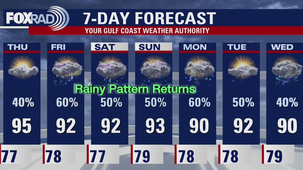
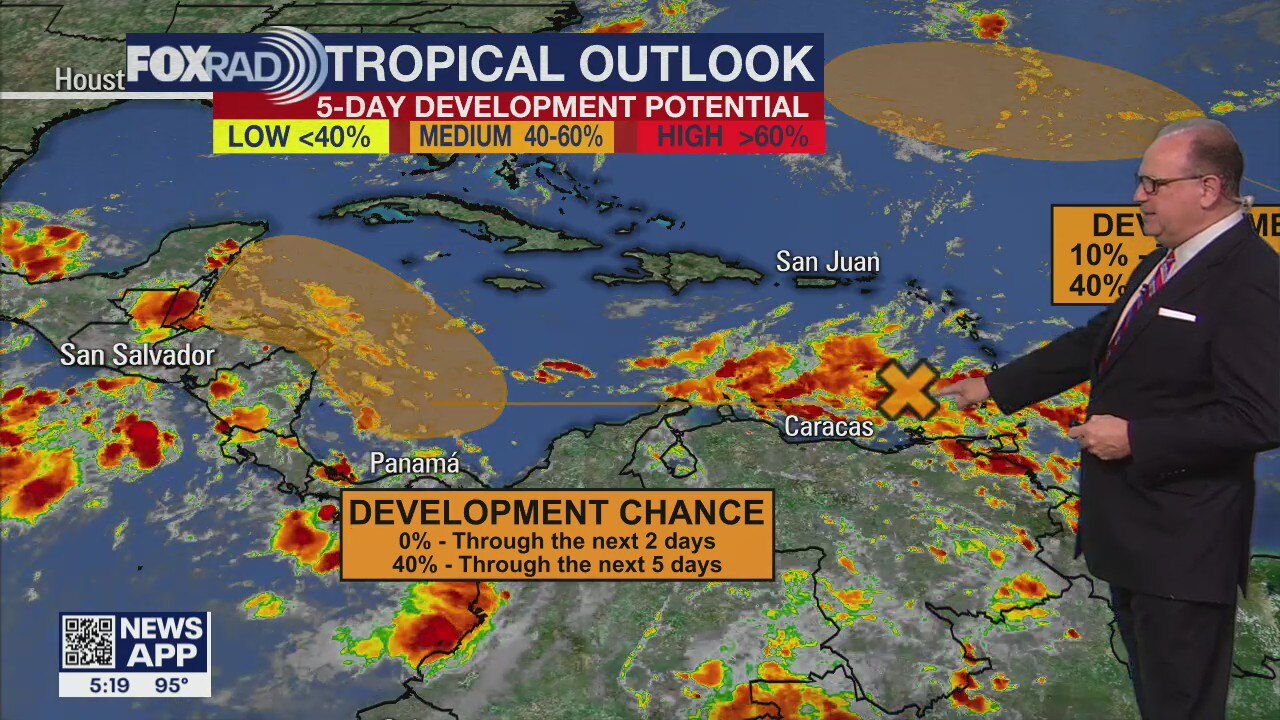
Still lots of talk about about the developing tropical system in the Caribbean that could affect our area early next week. For today and tomorrow, watch for afternoon storms and warm temps. This weekend in addition to scattered showers, we will closely monitor the progress of what is expected to be a named storm in the Gulf. If that system comes our way, the arrival time would by Sunday/Monday, but there is a lot of uncertainty since the system is disorganized and several days away.
Still lots of talk about about the developing tropical system in the Caribbean that could affect our area early next week. For today and tomorrow, watch for afternoon storms and warm temps. This weekend in addition to scattered showers, we will closely monitor the progress of what is expected to be a named storm in the Gulf. If that system comes our way, the arrival time would by Sunday/Monday, but there is a lot of uncertainty since the system is disorganized and several days away.
Thursday morning weather forecast
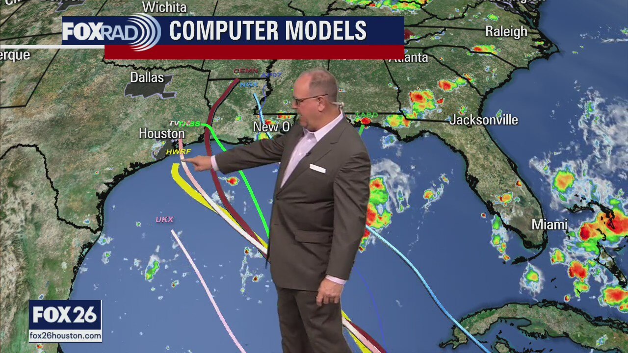
Tropical moisture unrelated to the low in the Caribbean will bring SE Texas rain starting on Fri. We continue to monitor the developing low and while it's too early to call, the trend is for the storm to head a little more towards Louisiana. We will have more confidence in the forecast when the weather models stop jumping around so much.
Tropical moisture unrelated to the low in the Caribbean will bring SE Texas rain starting on Fri. We continue to monitor the developing low and while it's too early to call, the trend is for the storm to head a little more towards Louisiana. We will have more confidence in the forecast when the weather models stop jumping around so much.

Wednesday evening weather forecast with Chief Meteorologist Dr. Jim Siebert
Tropical moisture unrelated to the low in the Caribbean will bring SE Texas rain starting on Fri. We continue to monitor the developing low and while it's too early to call, the trend is for the storm to head a little more towards Louisiana. We will have more confidence in the forecast when the weather models stop jumping around so much.
Tropical moisture unrelated to the low in the Caribbean will bring SE Texas rain starting on Fri. We continue to monitor the developing low and while it's too early to call, the trend is for the storm to head a little more towards Louisiana. We will have more confidence in the forecast when the weather models stop jumping around so much.
Tropical Weather Forecast - August 25, 2021
Tropical moisture unrelated to the low in the Caribbean will bring southeast Texas rain starting on Friday. We continue to monitor the developing low and while it's too early to call, the trend is for the storm to head a little more towards Louisiana. We will have more confidence in the forecast when the weather models stop jumping around so much.
Tropical moisture unrelated to the low in the Caribbean will bring southeast Texas rain starting on Friday. We continue to monitor the developing low and while it's too early to call, the trend is for the storm to head a little more towards Louisiana. We will have more confidence in the forecast when the weather models stop jumping around so much.
Wednesday weather forecast
Much of the weather chatter today will be about the developing tropical system in the Caribbean that could affect our area early next week. For today and tomorrow, watch for scattered late-day storms and hot temps. By Friday a plume of moisture unrelated to the tropical system moves in and should bring heavy storms with it. This weekend in addition to scattered showers, we will closely monitor the progress of (what could be) a tropical storm in the Gulf. If that system comes our way, the arrival time would be Sunday/Monday, but there is a lot of uncertainty since the system is disorganized and several days away.
Much of the weather chatter today will be about the developing tropical system in the Caribbean that could affect our area early next week. For today and tomorrow, watch for scattered late-day storms and hot temps. By Friday a plume of moisture unrelated to the tropical system moves in and should bring heavy storms with it. This weekend in addition to scattered showers, we will closely monitor the progress of (what could be) a tropical storm in the Gulf. If that system comes our way, the arrival time would be Sunday/Monday, but there is a lot of uncertainty since the system is disorganized and several days away.
Wednesday morning weather forecast
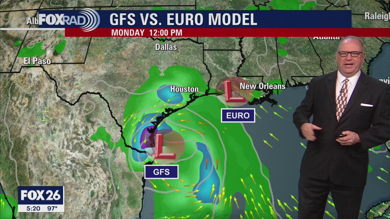
Deeper moisture will move into the area over the next few days and that will bring more rain. The wet pattern will last into next week. The possible tropical low expected in the southern Gulf by Sunday still looks to stay south of SE Texas. It is still too early to know anything for certain about it.
Deeper moisture will move into the area over the next few days and that will bring more rain. The wet pattern will last into next week. The possible tropical low expected in the southern Gulf by Sunday still looks to stay south of SE Texas. It is still too early to know anything for certain about it.
Tuesday Evening Weather Forecast
Deeper moisture will move into the area over the next few days and that will bring more rain. The wet pattern will last into next week. The possible tropical low expected in the southern Gulf by Sunday still looks to stay south of SE Texas. It is still too early to know anything for certain about it.
Deeper moisture will move into the area over the next few days and that will bring more rain. The wet pattern will last into next week. The possible tropical low expected in the southern Gulf by Sunday still looks to stay south of SE Texas. It is still too early to know anything for certain about it.
Tropical Weather Forecast - August 24, 2021
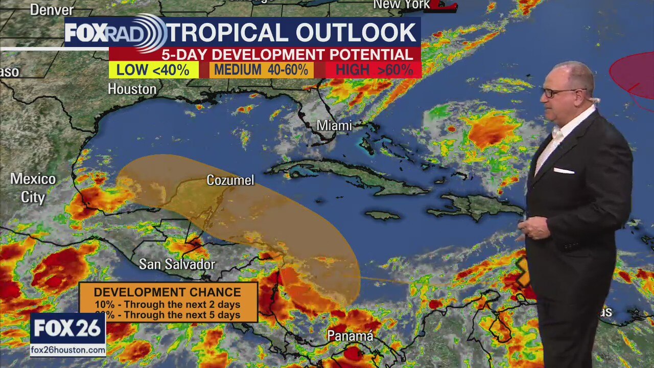
We continue to monitor the computer models for the possible tropical low that is currently in the Caribbean. The current trend is to keep whatever forms well south of the Houston area, but it is still too early to have any real confidence in the forecast.
We continue to monitor the computer models for the possible tropical low that is currently in the Caribbean. The current trend is to keep whatever forms well south of the Houston area, but it is still too early to have any real confidence in the forecast.
Sunny & hot day ahead
Today is going to be another scorcher, but changes are on the way. Beginning tomorrow, watch for a few late day storms as a big area of high pressure loses its hold on our weather. More moisture should lead to more frequent rain late this week, this weekend and early next week. There is a tropical wave in the Caribbean that has a pretty good chance of becoming a tropical depression or even a tropical storm. That system will most likely pass to our south, but it's something to watch and could bring heavy rain, so stay tuned.
Today is going to be another scorcher, but changes are on the way. Beginning tomorrow, watch for a few late day storms as a big area of high pressure loses its hold on our weather. More moisture should lead to more frequent rain late this week, this weekend and early next week. There is a tropical wave in the Caribbean that has a pretty good chance of becoming a tropical depression or even a tropical storm. That system will most likely pass to our south, but it's something to watch and could bring heavy rain, so stay tuned.
Tuesday morning weather update
The next couple of days look hot with only a few showers in the afternoon hours. Humidity will be on the rise by the end of the week and that will lead to more widespread showers. At least it will bring the temps down by a few degrees. There is an area of low pressure that will move into the southern Gulf of Mexico by early next week and we can?t write it off just yet. We?ll keep you posted on it.
The next couple of days look hot with only a few showers in the afternoon hours. Humidity will be on the rise by the end of the week and that will lead to more widespread showers. At least it will bring the temps down by a few degrees. There is an area of low pressure that will move into the southern Gulf of Mexico by early next week and we can?t write it off just yet. We?ll keep you posted on it.
Monday Evening Weather Forecast
The next couple of days look hot with only a few showers in the afternoon hours. Humidity will be on the rise by the end of the week and that will lead to more widespread showers. At least it will bring the temps down by a few degrees. There is an area of low pressure that will move into the southern Gulf of Mexico by early next week and we can?t write it off just yet. We?ll keep you posted on it.
The next couple of days look hot with only a few showers in the afternoon hours. Humidity will be on the rise by the end of the week and that will lead to more widespread showers. At least it will bring the temps down by a few degrees. There is an area of low pressure that will move into the southern Gulf of Mexico by early next week and we can?t write it off just yet. We?ll keep you posted on it.

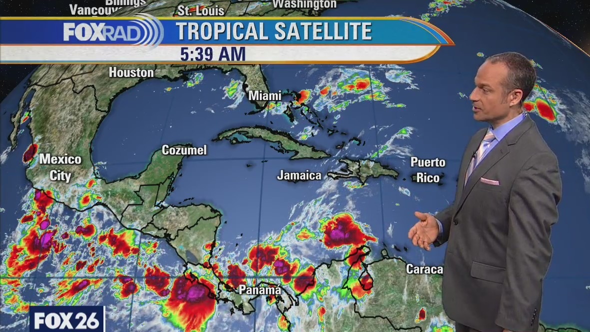
Tropical Weather Forecast - August 23, 2021
The tropics are very active, but nothing is pointed toward SE Texas as this time. Long-range models do show a low trying to develop in the eastern Gulf of Mexico the first week of September. It's far too early to trust anything about it.
The tropics are very active, but nothing is pointed toward SE Texas as this time. Long-range models do show a low trying to develop in the eastern Gulf of Mexico the first week of September. It's far too early to trust anything about it.
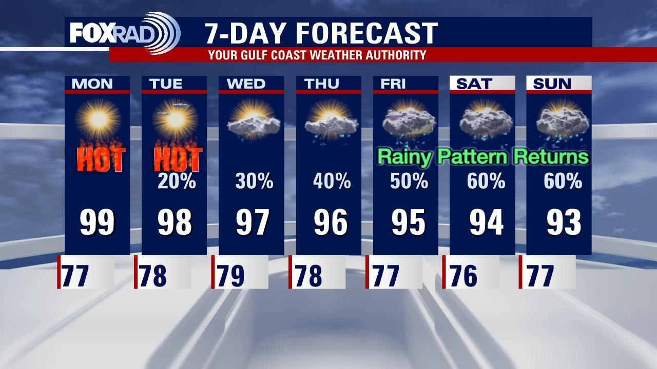
Monday weather forecast
More sunny, hot weather is on the way for today and likely tomorrow. Gradually this week clouds, showers and storms will increase and by Friday and this weekend, storms could be back. So far, there aren't any tropical concerns for us, but the season is still young.
More sunny, hot weather is on the way for today and likely tomorrow. Gradually this week clouds, showers and storms will increase and by Friday and this weekend, storms could be back. So far, there aren't any tropical concerns for us, but the season is still young.
Sunday evening weather forecast with FOX 26 Meteorologist John Dawson
There is still plenty more August heat here in Houston for the next several days. Look for rain chances to increase as we move through the week and temperatures should drop some as well. Next weekend looks like it could be more rain than the sun in Southeast Texas.
There is still plenty more August heat here in Houston for the next several days. Look for rain chances to increase as we move through the week and temperatures should drop some as well. Next weekend looks like it could be more rain than the sun in Southeast Texas.