

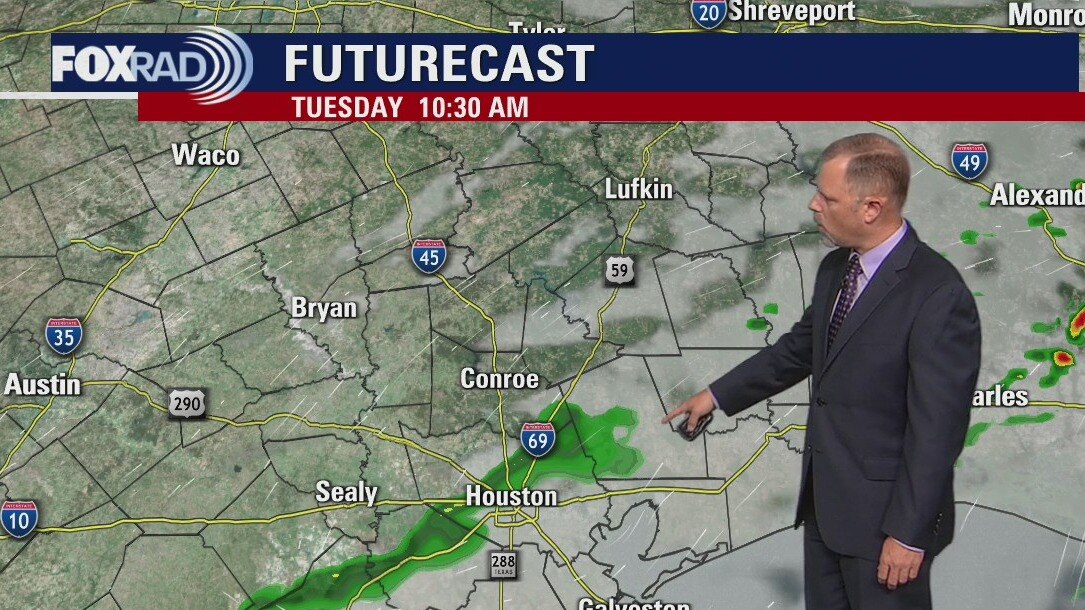
Tuesday morning weather forecast
A few showers are possible Tuesday morning, but the afternoon will see the warmest temperatures so far for this year in Houston. A front on Wednesday brings fantastic weather to end the week.
A few showers are possible Tuesday morning, but the afternoon will see the warmest temperatures so far for this year in Houston. A front on Wednesday brings fantastic weather to end the week.
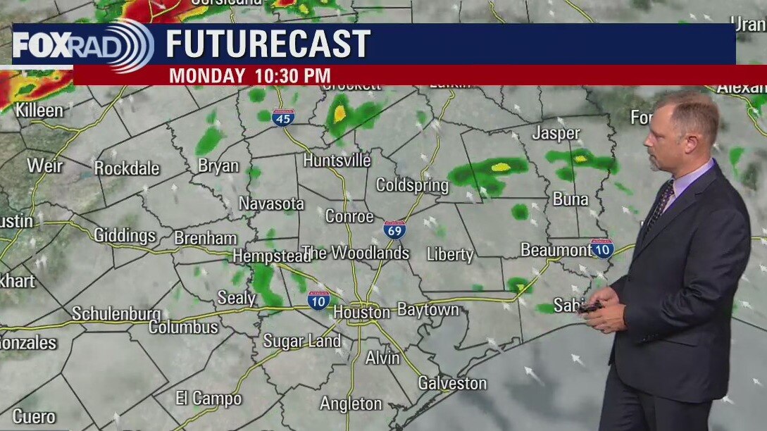
Monday evening weather forecast
Monday night should see some showers and isolated storms around Southeast Texas. A few showers are possible Tuesday morning but the afternoon will see the warmest temperatures so far for this year in Houston. A front on Wednesday brings fantastic weather to end the week.
Monday night should see some showers and isolated storms around Southeast Texas. A few showers are possible Tuesday morning but the afternoon will see the warmest temperatures so far for this year in Houston. A front on Wednesday brings fantastic weather to end the week.
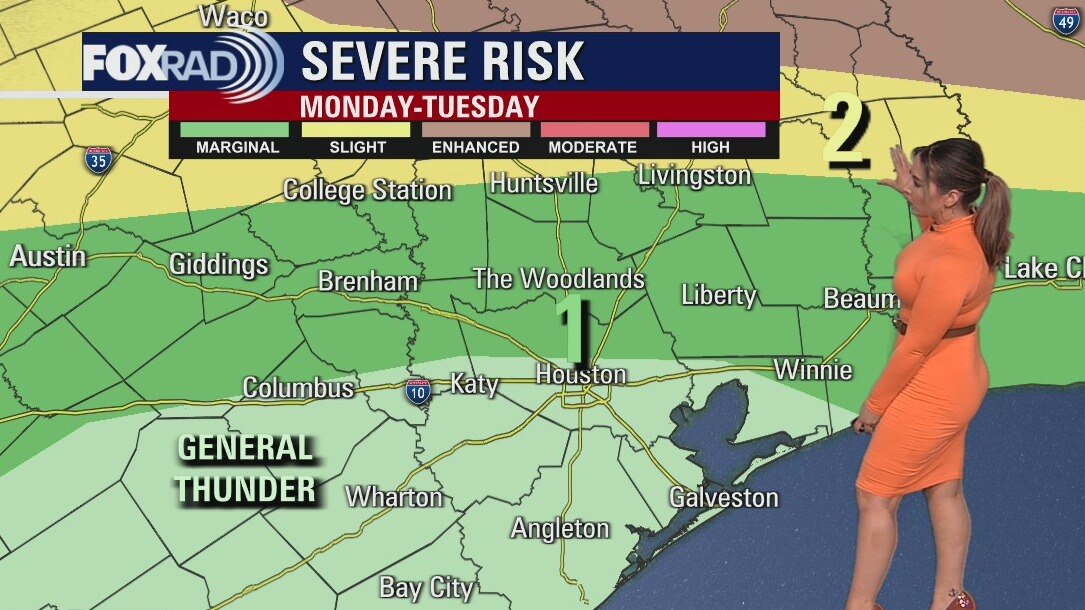
Monday Afternoon Weather Forecast
Today, unlikely we make it past 80 due to clouds. But tomorrow, many will see their first 90 degree day this year. Records in the Houston-metro area may get matched, if not exceeded. And if cooler temps is more your cup of tea, we end the week that way. Somethin' for everyone!
Today, unlikely we make it past 80 due to clouds. But tomorrow, many will see their first 90 degree day this year. Records in the Houston-metro area may get matched, if not exceeded. And if cooler temps is more your cup of tea, we end the week that way. Somethin' for everyone!
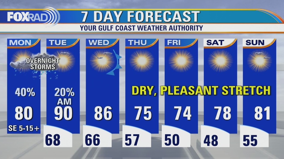
Monday afternoon weather forecast
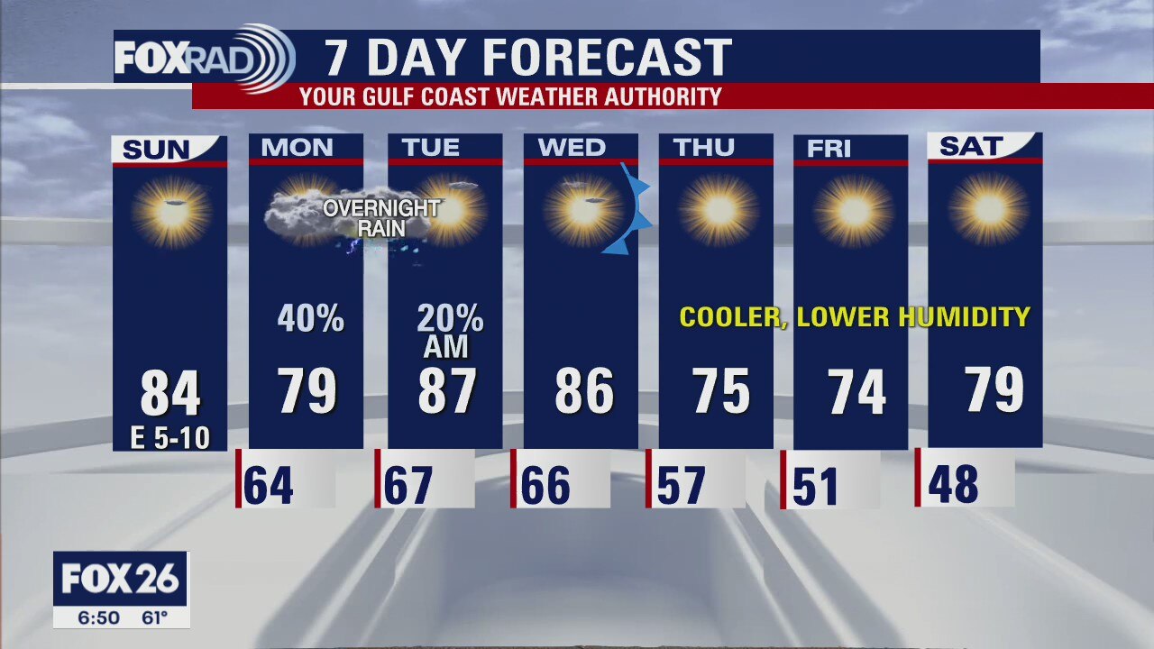
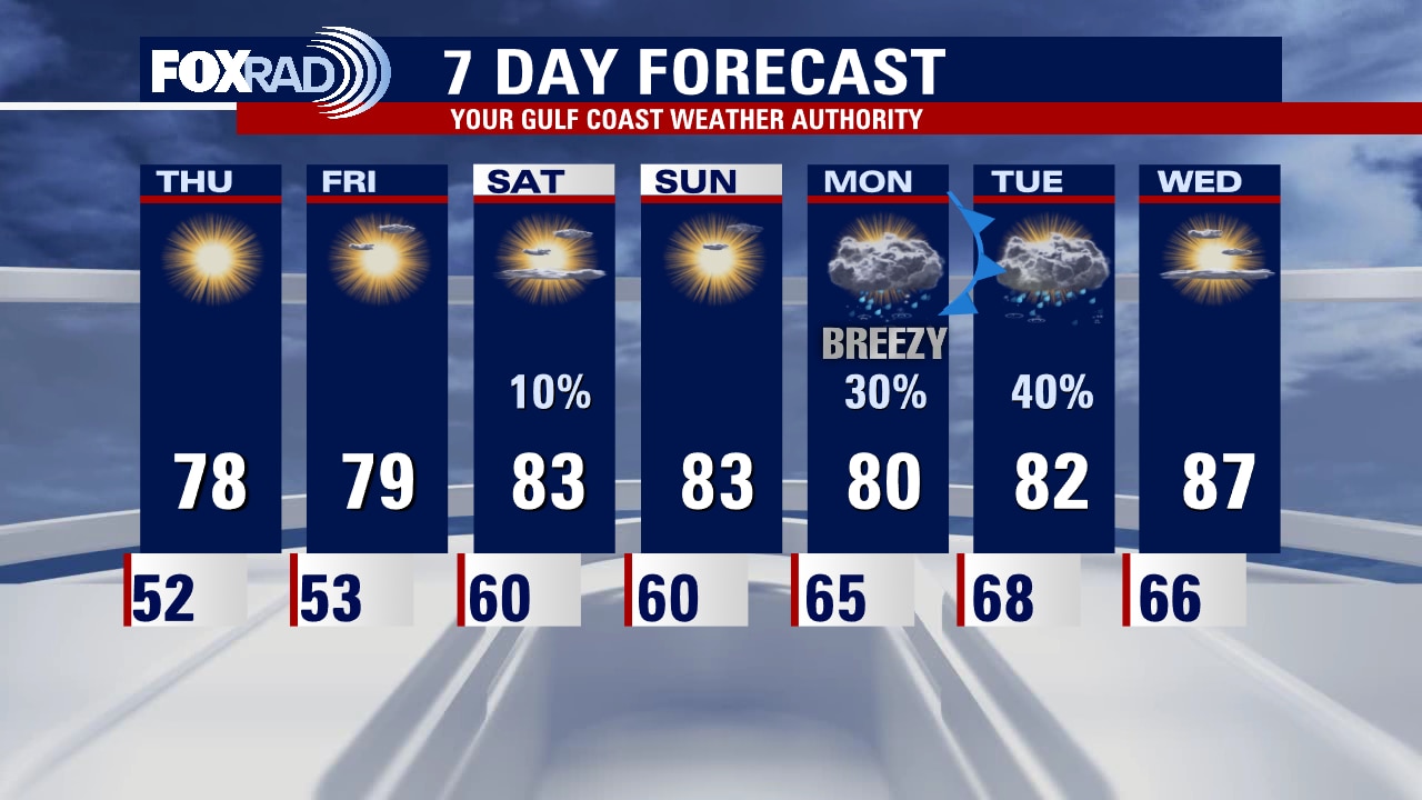
Monday will be warm, humid and mostly cloudy with scattered showers throughout the day. We are closely watching for the potential for some isolated stronger weather in the overnight hours, mainly well north of Houston. For most, it be quick hitting rain with possibly some rumbles of thunder with less than 1/2" total accumulation. The action tapers off quickly by Tuesday mid-morning, and Tuesday afternoon will likely be the warmest of the year so far for many locations. We hang onto that warmth on Wednesday as we wait for the front and the wind shift to usher in cooler, drier air to close out the week. Rain chances don't re-introduce themselves into the forecast again until next week.
Monday will be warm, humid and mostly cloudy with scattered showers throughout the day. We are closely watching for the potential for some isolated stronger weather in the overnight hours, mainly well north of Houston. For most, it be quick hitting rain with possibly some rumbles of thunder with less than 1/2" total accumulation. The action tapers off quickly by Tuesday mid-morning, and Tuesday afternoon will likely be the warmest of the year so far for many locations. We hang onto that warmth on Wednesday as we wait for the front and the wind shift to usher in cooler, drier air to close out the week. Rain chances don't re-introduce themselves into the forecast again until next week.

Sunday night leading into Monday morning weather forecast with Meteorologist John Dawson
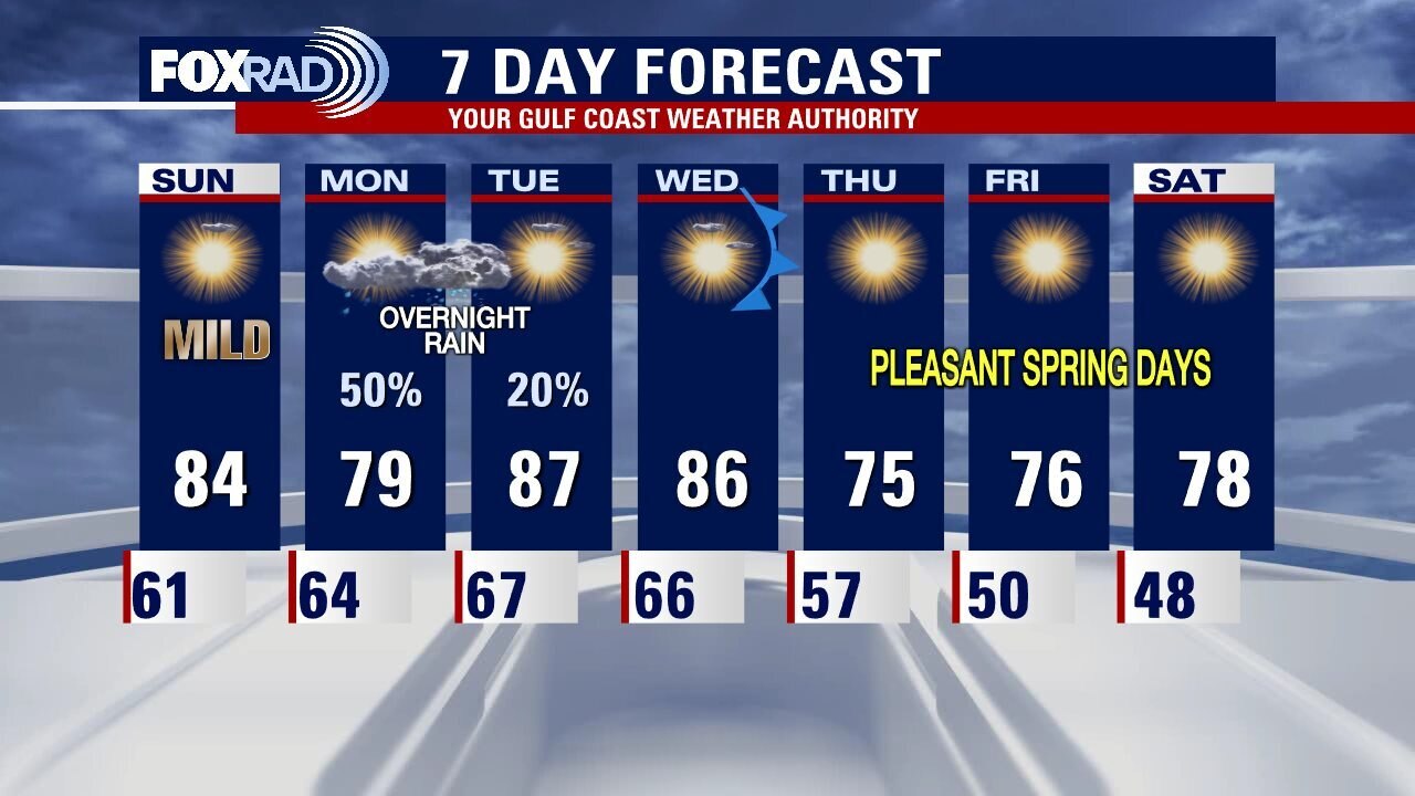
Southeast Texas will see some showers on Monday with some isolated storms Monday night. Tuesday will probably be the warmest day in Houston so far this year with afternoon highs close to 90. A front brings some drier and cooler air into the forecast for the end of the workweek.
Southeast Texas will see some showers on Monday with some isolated storms Monday night. Tuesday will probably be the warmest day in Houston so far this year with afternoon highs close to 90. A front brings some drier and cooler air into the forecast for the end of the workweek.
Your Sunday Morning Forecast with Meteorologist Lena Maria
After a foggy start to your Sunday morning, the afternoon is looking fantastic. The work week will be off to a bit of a soggy start, but nothing overly concerning in terms of commutes for work and school. Monday features scattered light quick moving showers, with some isolated thunderstorms possible in the overnight hours into Tuesday. Any strong to severe weather while possible looks to be kept at a minimum locally, and once the sun returns by midday Tuesday we're in for the warmest temps we've seen so far this season. The front, or the wind shift does not occur until Wednesday when northwesterly breezes will usher in cooler, drier air as we head into the weekend.
After a foggy start to your Sunday morning, the afternoon is looking fantastic. The work week will be off to a bit of a soggy start, but nothing overly concerning in terms of commutes for work and school. Monday features scattered light quick moving showers, with some isolated thunderstorms possible in the overnight hours into Tuesday. Any strong to severe weather while possible looks to be kept at a minimum locally, and once the sun returns by midday Tuesday we're in for the warmest temps we've seen so far this season. The front, or the wind shift does not occur until Wednesday when northwesterly breezes will usher in cooler, drier air as we head into the weekend.
Saturday evening leading into Sunday weather forecast with Meteorologist John Dawson
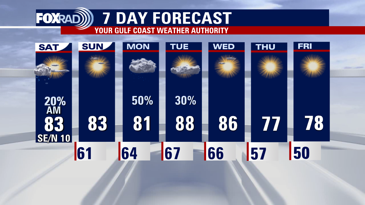
The rest of the weekend looks great in Southeast Texas. Patchy fog is possible Sunday morning but the afternoon looks beautiful. Late Monday the next round of showers/storms moves towards Houston. Most of the rain will happen overnight Monday into early Tuesday morning. A weak cold front will produce some great weather for outdoor activities at the end of the week.
The rest of the weekend looks great in Southeast Texas. Patchy fog is possible Sunday morning but the afternoon looks beautiful. Late Monday the next round of showers/storms moves towards Houston. Most of the rain will happen overnight Monday into early Tuesday morning. A weak cold front will produce some great weather for outdoor activities at the end of the week.
Saturday afternoon weather forecast with Meteorologist Mike Iscovitz
We have some great spring weather on the way for today and tomorrow with highs in the low to mid-80s and very low chances for rain. Clouds and south winds return Monday, so showers look likely along with isolated storms. Rain should come to an end early Tuesday followed by a very warm afternoon - possibly the warmest of 2022 so far. Finally, allergy levels will remain very high with oak and pine pollen the primary factors.
We have some great spring weather on the way for today and tomorrow with highs in the low to mid-80s and very low chances for rain. Clouds and south winds return Monday, so showers look likely along with isolated storms. Rain should come to an end early Tuesday followed by a very warm afternoon - possibly the warmest of 2022 so far. Finally, allergy levels will remain very high with oak and pine pollen the primary factors.
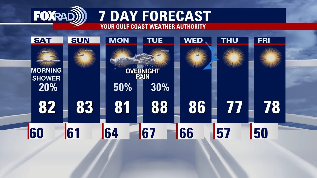
Saturday morning weather forecast
A few morning showers will find their way into Southeast Texas on Saturday morning. Houston should see fantastic weather for the afternoon and the rest of the weekend. Overnight showers/storms will be back in the forecast again for Monday evening. Look for a pleasant week after that storm system clears on Tuesday morning.
A few morning showers will find their way into Southeast Texas on Saturday morning. Houston should see fantastic weather for the afternoon and the rest of the weekend. Overnight showers/storms will be back in the forecast again for Monday evening. Look for a pleasant week after that storm system clears on Tuesday morning.
Friday evening weather forecast with Meteorologist John Dawson
A few morning showers will find their way into Southeast Texas on Saturday morning. Houston should see fantastic weather for the afternoon and the rest of the weekend. Overnight showers/storms will be back in the forecast again for Monday evening. Look for a pleasant week after that storm system clears on Tuesday morning.
A few morning showers will find their way into Southeast Texas on Saturday morning. Houston should see fantastic weather for the afternoon and the rest of the weekend. Overnight showers/storms will be back in the forecast again for Monday evening. Look for a pleasant week after that storm system clears on Tuesday morning.
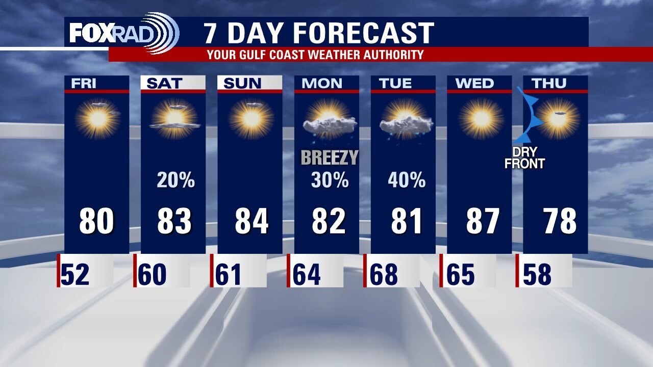
Friday afternoon weather forecast
The April Fool's Day forecast is looking great once again with low humidity and sunshine. An east breeze should kick in by this afternoon, but otherwise the only issue today will be the very high levels of tree pollen. For the weekend, a few showers are possible early Saturday morning followed by more pleasant weather. Storms are possible by Monday and early Tuesday.
The April Fool's Day forecast is looking great once again with low humidity and sunshine. An east breeze should kick in by this afternoon, but otherwise the only issue today will be the very high levels of tree pollen. For the weekend, a few showers are possible early Saturday morning followed by more pleasant weather. Storms are possible by Monday and early Tuesday.
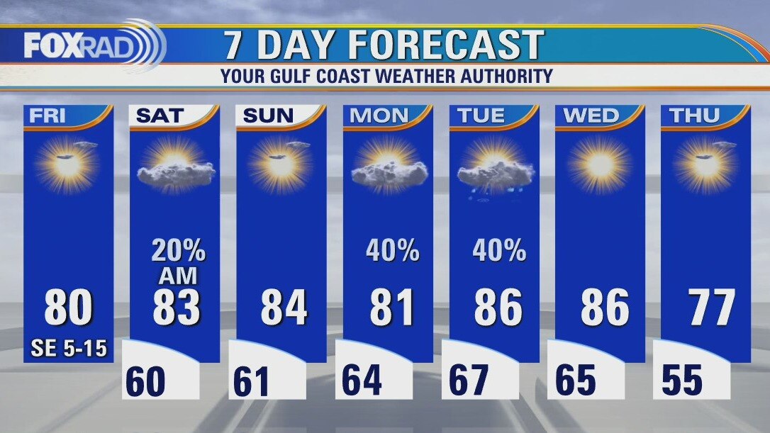
Friday morning weather forecast
Friday looks fantastic across Southeast Texas! Saturday morning could see a few coastal showers but most of the weekend looks good for outdoor activities. The 7 Day forecast has a few chances for rain but Houston should avoid any strong storms over this period.
Friday looks fantastic across Southeast Texas! Saturday morning could see a few coastal showers but most of the weekend looks good for outdoor activities. The 7 Day forecast has a few chances for rain but Houston should avoid any strong storms over this period.
Thursday evening weather forecast with Meteorologist John Dawson
Friday looks fantastic across Southeast Texas! Saturday morning could see a few coastal showers but most of the weekend looks good for outdoor activities. The 7 Day forecast has a few chances for rain but Houston should avoid any strong storms over this period.
Friday looks fantastic across Southeast Texas! Saturday morning could see a few coastal showers but most of the weekend looks good for outdoor activities. The 7 Day forecast has a few chances for rain but Houston should avoid any strong storms over this period.

Late Thursday afternoon weather forecast with Meteorologist Lena Maria Arango
There is plenty of good news in our weather forecast for the next few days with very low humidity in place today. Look for sunshine, a little haze from smoke and West Texas dust possible, and very pleasant temperatures. Friday looks great as well. Watch for a few showers or storms early Saturday followed by more mild spring afternoons. rain should return early next week. Lastly, tree pollen levels are likely to remain very high for the next several days.
There is plenty of good news in our weather forecast for the next few days with very low humidity in place today. Look for sunshine, a little haze from smoke and West Texas dust possible, and very pleasant temperatures. Friday looks great as well. Watch for a few showers or storms early Saturday followed by more mild spring afternoons. rain should return early next week. Lastly, tree pollen levels are likely to remain very high for the next several days.
Thursday afternoon weather forecast
There is plenty of good news in our weather forecast for the next few days with very low humidity in place today. Look for sunshine, a little haze from smoke and West Texas dust possible, and very pleasant temperatures. Friday looks great as well. Watch for a few showers or storms early Saturday followed by more mild spring afternoons. rain should return early next week. Lastly, tree pollen levels are likely to remain very high for the next several days.
There is plenty of good news in our weather forecast for the next few days with very low humidity in place today. Look for sunshine, a little haze from smoke and West Texas dust possible, and very pleasant temperatures. Friday looks great as well. Watch for a few showers or storms early Saturday followed by more mild spring afternoons. rain should return early next week. Lastly, tree pollen levels are likely to remain very high for the next several days.
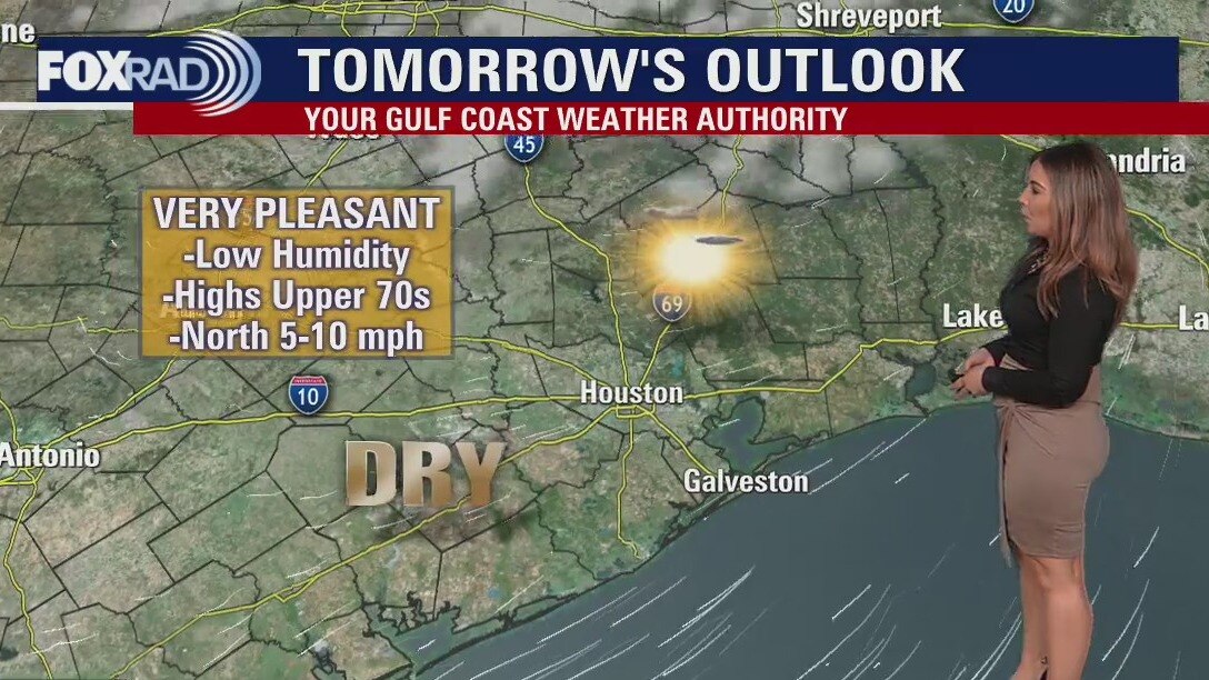
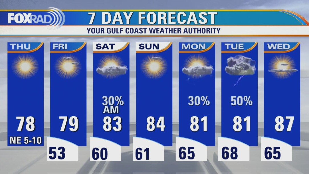
Thursday morning weather forecast
Winds will be much lighter as we close out the work week and head into the weekend. In general, a stretch of dry and pleasant weather is on tap for southeast Texas. A very weak surface cold front could squeeze out a spot shower or sprinkle overnight Friday into Saturday, with a more promising chance for rain at the start of next week.
Winds will be much lighter as we close out the work week and head into the weekend. In general, a stretch of dry and pleasant weather is on tap for southeast Texas. A very weak surface cold front could squeeze out a spot shower or sprinkle overnight Friday into Saturday, with a more promising chance for rain at the start of next week.
Wednesday evening weather forecast with Meteorologist Lena Maria Arango
Winds will be much lighter as we close out the work week and head into the weekend. In general, a stretch of dry and pleasant weather is on tap for southeast Texas. A very weak surface cold front could squeeze out a spot shower or sprinkle overnight Friday into Saturday, with a more promising chance for rain at the start of next week.
Winds will be much lighter as we close out the work week and head into the weekend. In general, a stretch of dry and pleasant weather is on tap for southeast Texas. A very weak surface cold front could squeeze out a spot shower or sprinkle overnight Friday into Saturday, with a more promising chance for rain at the start of next week.
Noon weather forecast with Meteorologist Mike Iscovitz
A "red flag warning" is in effect from 1 p.m.-to 7 p.m. today to warn of the potential for wildfires should a spark cause grass or brush fire. Beyond today, beautiful weather is on the way to wrap up this week with lows in the 50s and highs near 80.
A "red flag warning" is in effect from 1 p.m.-to 7 p.m. today to warn of the potential for wildfires should a spark cause grass or brush fire. Beyond today, beautiful weather is on the way to wrap up this week with lows in the 50s and highs near 80.

Wednesday afternoon weather forecast
The National Weather Service has placed us under a rare "Red Flag Warning" due to very dry air and gusty winds expected from 1-7pm today. This is nothing to be alarmed about, but care should be taken, especially in grassy/wooded areas to prevent a spark or even a small fire. Despite mid morning thunderstorms, water from the brief rainfall could evaporate quickly and gusty west winds could spread any small brush fire that may form. The good news is that we'll finally get a break from windy conditions tomorrow with high pressure moving in.
The National Weather Service has placed us under a rare "Red Flag Warning" due to very dry air and gusty winds expected from 1-7pm today. This is nothing to be alarmed about, but care should be taken, especially in grassy/wooded areas to prevent a spark or even a small fire. Despite mid morning thunderstorms, water from the brief rainfall could evaporate quickly and gusty west winds could spread any small brush fire that may form. The good news is that we'll finally get a break from windy conditions tomorrow with high pressure moving in.
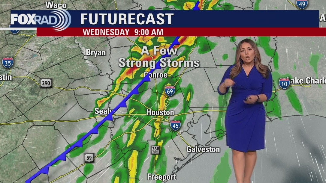
Wednesday morning weather forecast
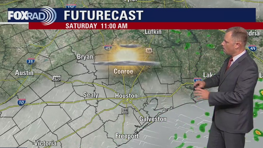
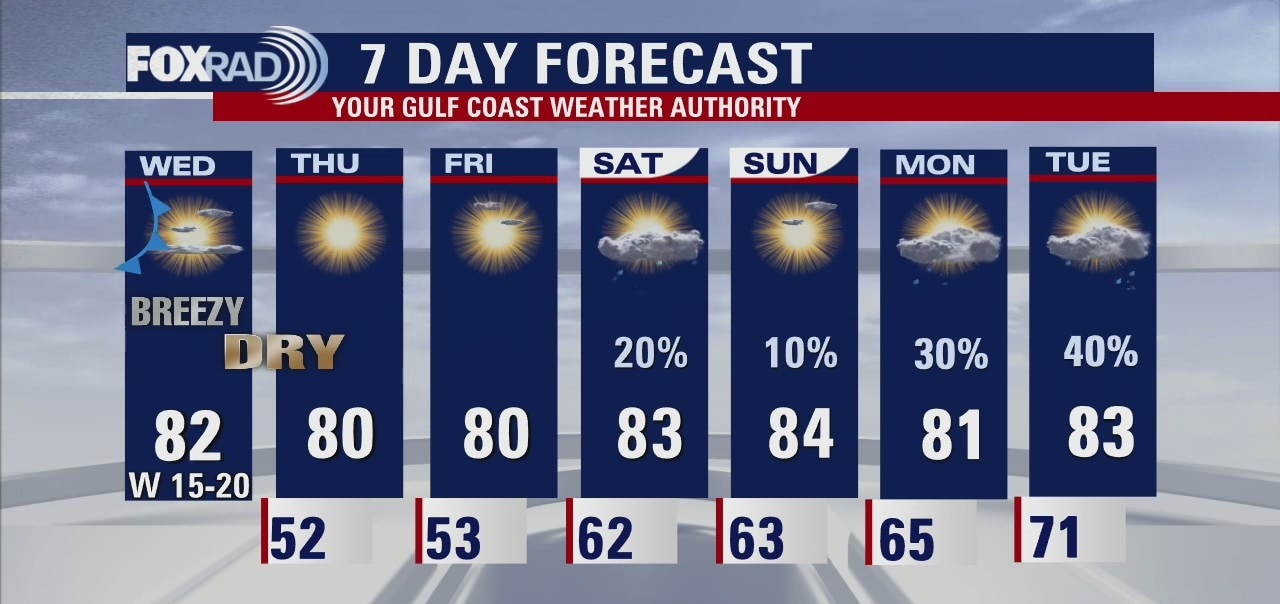
A cold front will bring a brief dose of showers and storms to southeast Texas on Wednesday morning. Severe weather is not expected, but rain could be briefly heavy along with some gusty winds. There is a Wind Advisory in effect for most of the area through 7 am Wednesday morning, and then a Fire Weather Watch from 1 p.m. - 7 p.m. for southwestern portions of the viewing area. Sun returns quickly by lunch Wednesday. Thursday and Friday will be a touch cooler, and much less humid. Another front brings shower chances overnight Friday into Saturday, with a third front at the start of next week. The good news is, the rain will help with allergies and we definitely need it due to the developing drought conditions!
A cold front will bring a brief dose of showers and storms to southeast Texas on Wednesday morning. Severe weather is not expected, but rain could be briefly heavy along with some gusty winds. There is a Wind Advisory in effect for most of the area through 7 am Wednesday morning, and then a Fire Weather Watch from 1 p.m. - 7 p.m. for southwestern portions of the viewing area. Sun returns quickly by lunch Wednesday. Thursday and Friday will be a touch cooler, and much less humid. Another front brings shower chances overnight Friday into Saturday, with a third front at the start of next week. The good news is, the rain will help with allergies and we definitely need it due to the developing drought conditions!