

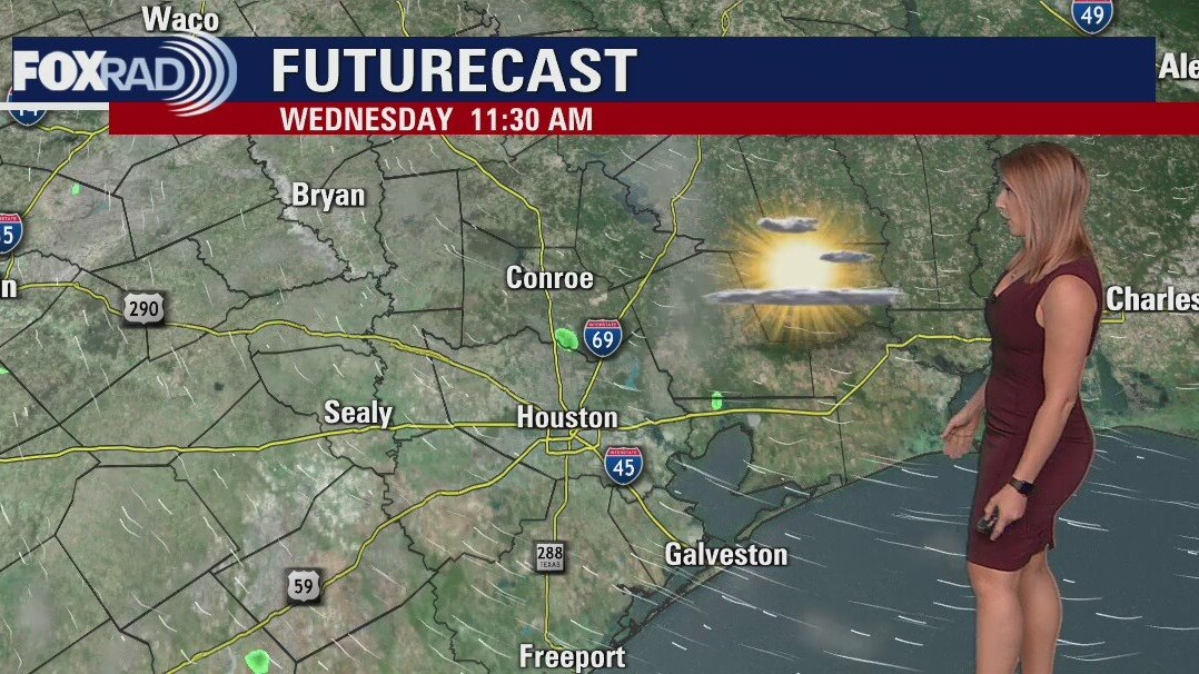
Wednesday morning weather forecast
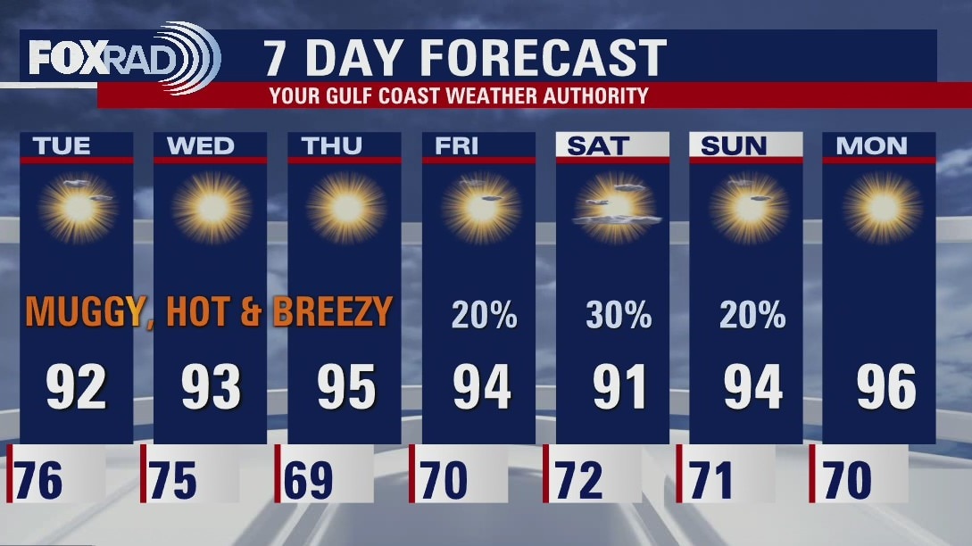
High heat continues to grip the region with temperatures remaining well above average. A few scattered showers and storms will be possible on Saturday. Unfortunately, it won't offer up any heat relief. Hot and humid conditions are expected to continue into next week.
High heat continues to grip the region with temperatures remaining well above average. A few scattered showers and storms will be possible on Saturday. Unfortunately, it won't offer up any heat relief. Hot and humid conditions are expected to continue into next week.
Tuesday evening weather forecast
High heat continues to grip the region with temperatures remaining well above average. A few scattered showers and storms will be possible on Saturday. Unfortunately, it won't offer up any heat relief. Hot and humid conditions are expected to continue into next week.
High heat continues to grip the region with temperatures remaining well above average. A few scattered showers and storms will be possible on Saturday. Unfortunately, it won't offer up any heat relief. Hot and humid conditions are expected to continue into next week.
Tuesday afternoon weather forecast
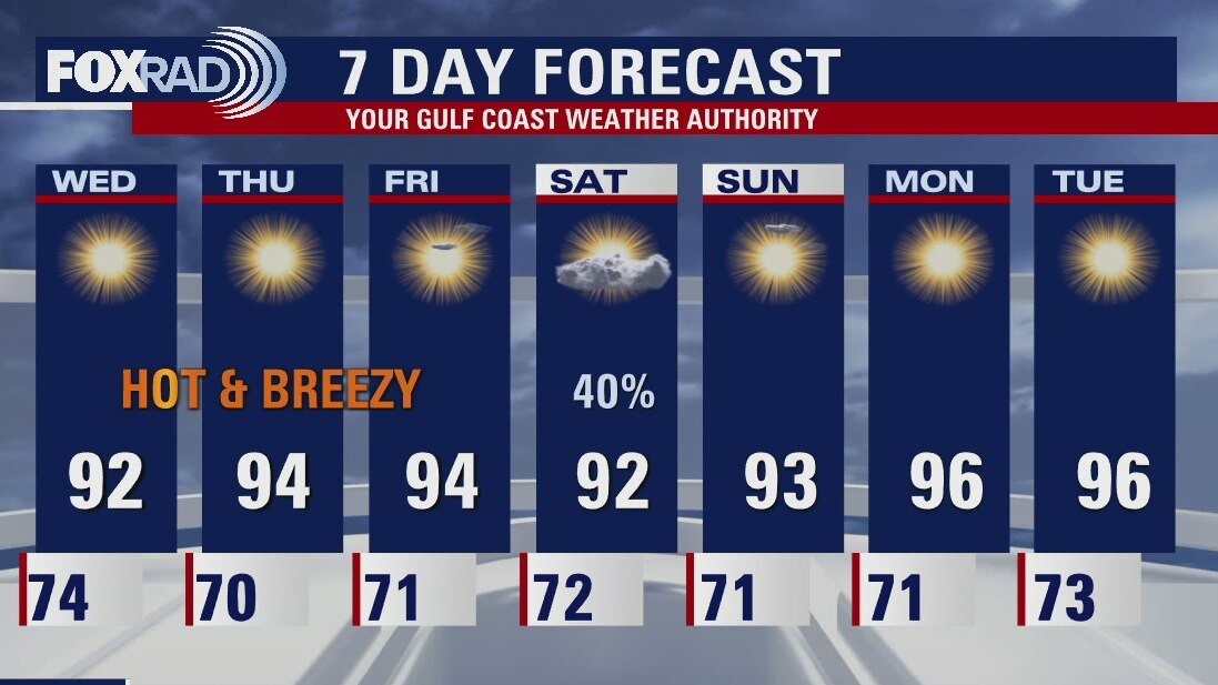
There are very few changes to our weather outlook for the next week or two. Other than a brief chance for storms Saturday, our overall pattern of well above normal temperatures should stay with us all the way through next week. You may notice a slight drop in temperatures Thursday and Friday morning, but nothing too exciting.
There are very few changes to our weather outlook for the next week or two. Other than a brief chance for storms Saturday, our overall pattern of well above normal temperatures should stay with us all the way through next week. You may notice a slight drop in temperatures Thursday and Friday morning, but nothing too exciting.
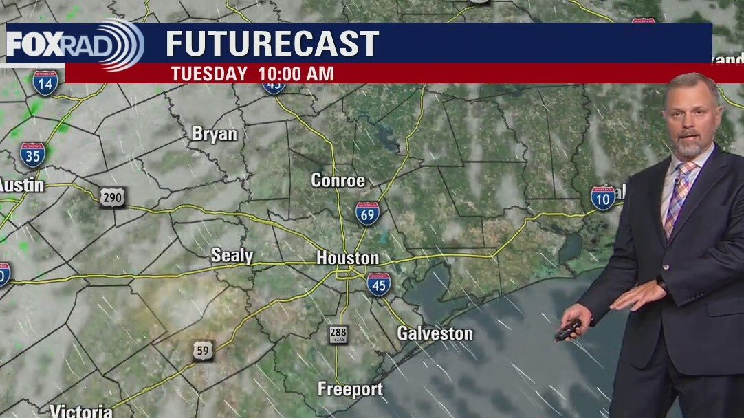
Tuesday morning weather forecast
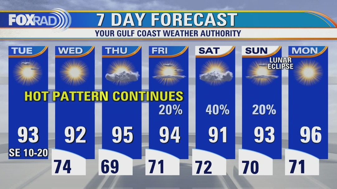
The hot pattern continues for Southeast Texas. Houston will see afternoon highs near records for the next several days. Thursday morning should bring a slight bit of help with some slightly less humid air. The next best rain chances are fairly low and come with the weekend.
The hot pattern continues for Southeast Texas. Houston will see afternoon highs near records for the next several days. Thursday morning should bring a slight bit of help with some slightly less humid air. The next best rain chances are fairly low and come with the weekend.
Monday evening weather forecast
The hot pattern continues for Southeast Texas. Houston will see afternoon highs near records for the next several days. Thursday morning should bring a slight bit of help with some slightly less humid air. The next best rain chances are fairly low and come with the weekend.
The hot pattern continues for Southeast Texas. Houston will see afternoon highs near records for the next several days. Thursday morning should bring a slight bit of help with some slightly less humid air. The next best rain chances are fairly low and come with the weekend.
Monday afternoon weather forecast
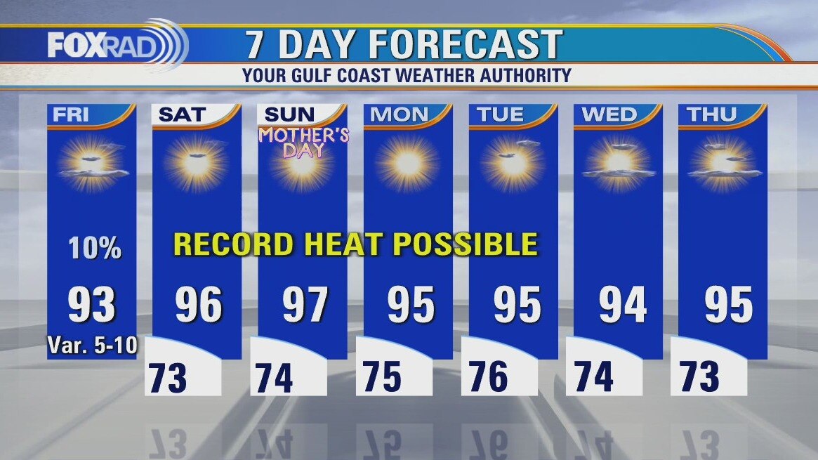
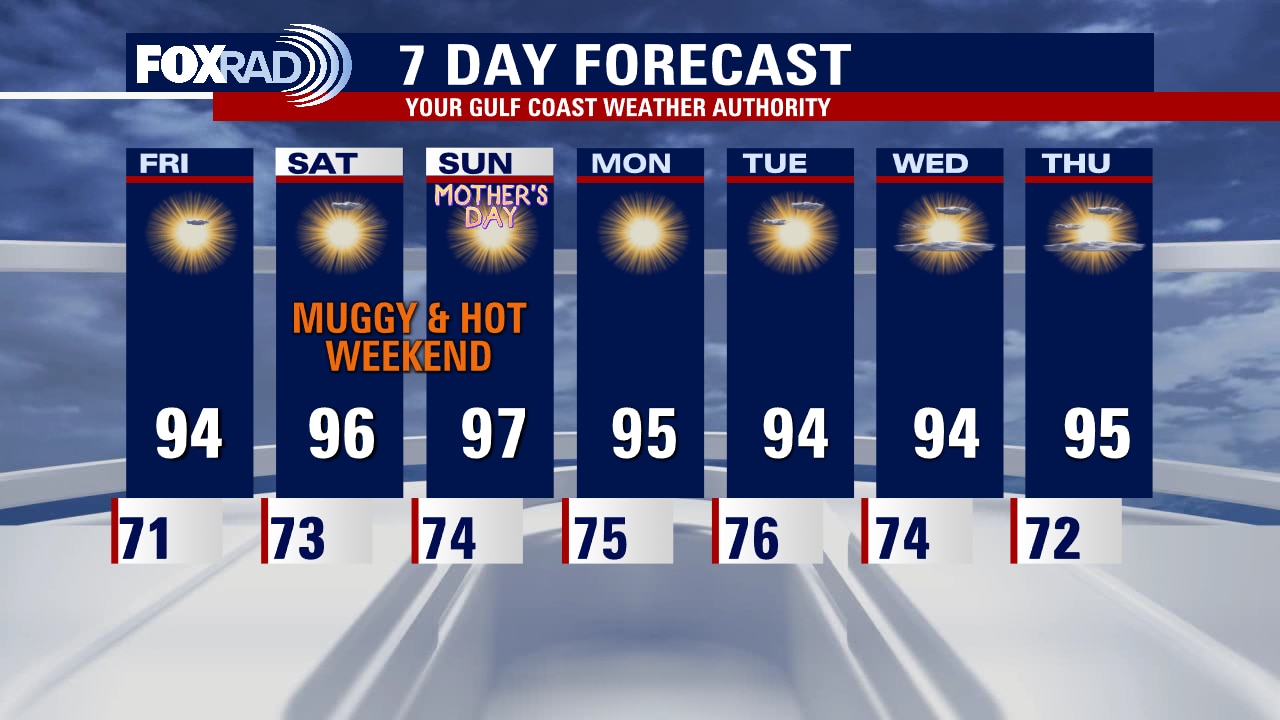
After a weekend of record highs in Galveston and near records in Houston, the heat wave will continue for us until at least Friday. Rain is unlikely through Thursday, then there is a chance for isolated rain Friday and possible a few storms on Saturday. Otherwise, expect steamy mornings and breezy, hot days.
After a weekend of record highs in Galveston and near records in Houston, the heat wave will continue for us until at least Friday. Rain is unlikely through Thursday, then there is a chance for isolated rain Friday and possible a few storms on Saturday. Otherwise, expect steamy mornings and breezy, hot days.
Monday morning weather forecast
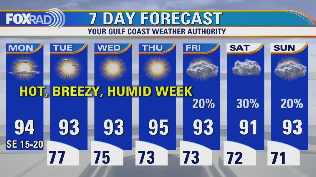
Not much change to discuss over this week. Houston will remain hot, humid and within the record-breaking territory for both overnight lows and daytime highs. The morning starts off mostly cloudy and muggy. Breezes out of the south will help somewhat in the afternoons. As high pressure moves directly overhead late week, morning lows should be slightly cooler. Still looking to remain rain-free for an extended period in Southeast Texas.
Not much change to discuss over this week. Houston will remain hot, humid and within the record-breaking territory for both overnight lows and daytime highs. The morning starts off mostly cloudy and muggy. Breezes out of the south will help somewhat in the afternoons. As high pressure moves directly overhead late week, morning lows should be slightly cooler. Still looking to remain rain-free for an extended period in Southeast Texas.
Your Sunday Morning Forecast With Meteorologist Lena Maria
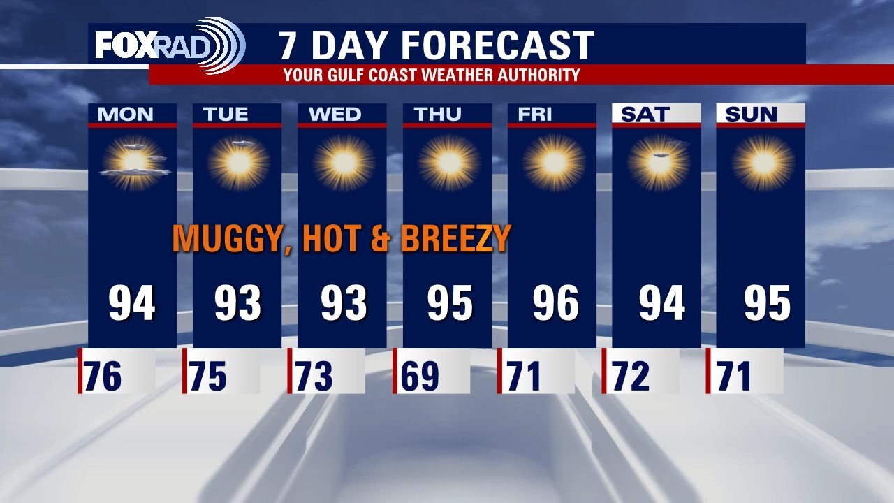
Not much changes over the course of the next 7 days, we remain hot, humid and within record breaking territory for both overnight lows and daytime highs. Breezes out of the south will help somewhat in the afternoons. As high pressure moves directly overhead late week, morning lows will at least be slightly cooler. Still looking to remain rain free for the extended period.
Not much changes over the course of the next 7 days, we remain hot, humid and within record breaking territory for both overnight lows and daytime highs. Breezes out of the south will help somewhat in the afternoons. As high pressure moves directly overhead late week, morning lows will at least be slightly cooler. Still looking to remain rain free for the extended period.

Saturday night leading into Mother's Day weather forecast with Meteorologist Adrienne Vonn
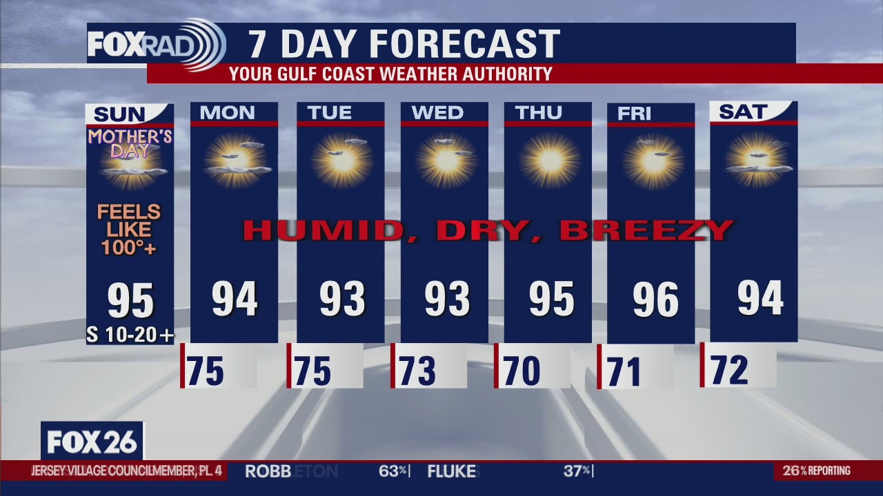
Hazy, hot, and humid conditions are on tap again tomorrow. After morning clouds clear, plenty of sunshine is expected for Mother's Day afternoon. Highs will soar close to record levels with top temperatures climbing the mid-90s. This summer-like pattern looks to continue into next week.
Hazy, hot, and humid conditions are on tap again tomorrow. After morning clouds clear, plenty of sunshine is expected for Mother's Day afternoon. Highs will soar close to record levels with top temperatures climbing the mid-90s. This summer-like pattern looks to continue into next week.
Saturday Morning Forecast with Meteorologist Lena Maria
An early season heat wave has prompted our first heat advisory of the season, about a month ahead of schedule. We'll be flirting with record lows, record highs and heat advisory criteria for at least the next week as a blocking pattern keeps us firmly parked in this pattern. In addition to being very hot, it will also by dry. Rain activity will be very limited, if not non-existent.
An early season heat wave has prompted our first heat advisory of the season, about a month ahead of schedule. We'll be flirting with record lows, record highs and heat advisory criteria for at least the next week as a blocking pattern keeps us firmly parked in this pattern. In addition to being very hot, it will also by dry. Rain activity will be very limited, if not non-existent.
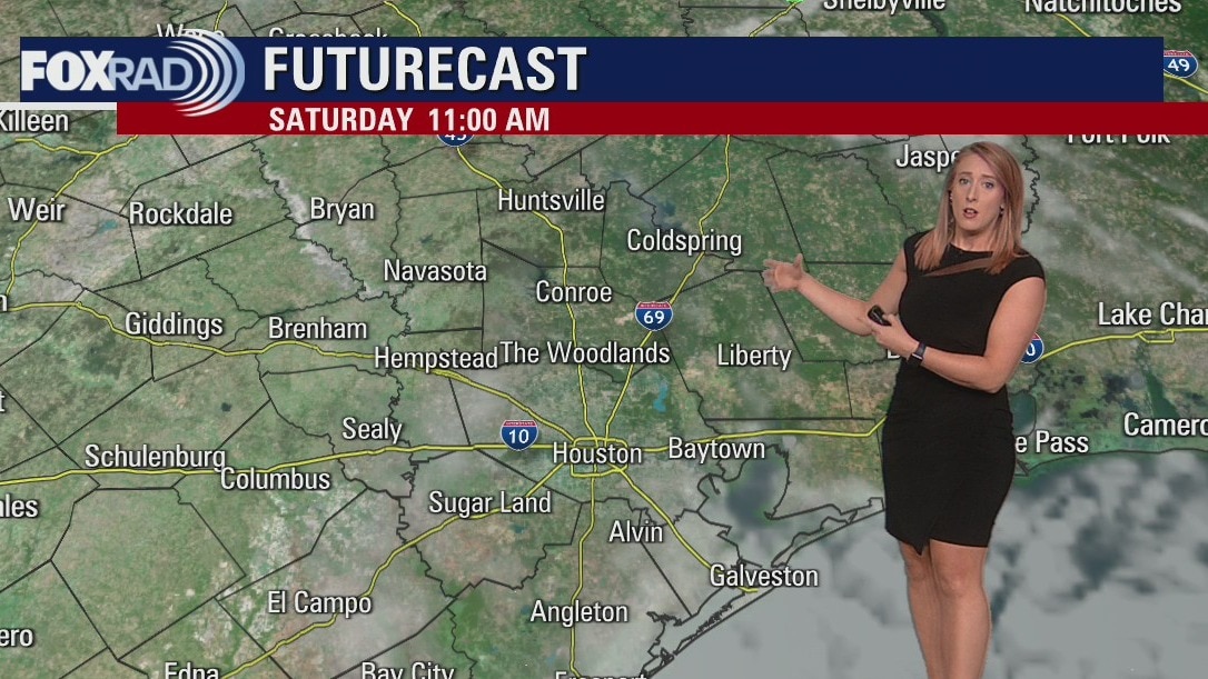
Saturday morning weather forecast
Summer-like heat is settling in this weekend across the Houston area. High temperatures will be close to record territory both Saturday and Sunday with heat index values soaring into the triple digits. A heat advisory has already been issued for Saturday noon - 7pm. Make sure you are drinking plenty of water and taking breaks often in the shade and AC!
Summer-like heat is settling in this weekend across the Houston area. High temperatures will be close to record territory both Saturday and Sunday with heat index values soaring into the triple digits. A heat advisory has already been issued for Saturday noon - 7pm. Make sure you are drinking plenty of water and taking breaks often in the shade and AC!
Friday afternoon weather forecast
Get ready for a hot Mother's Day weekend and at least a week of record or near record heat and little to no rain. Thursday night rain totals exceeded 3" north of Houston, but that is the last we'll see for a while (although there is a slight chance for an isolated storm south of Houston late today). Look for sunshine and highs in the mid 90s for the next 7 days as a large ridge (high pressure) in the jet stream takes hold. This system will bring a heat wave from the Rio Grande Valley to the Midwest for early next week.
Get ready for a hot Mother's Day weekend and at least a week of record or near record heat and little to no rain. Thursday night rain totals exceeded 3" north of Houston, but that is the last we'll see for a while (although there is a slight chance for an isolated storm south of Houston late today). Look for sunshine and highs in the mid 90s for the next 7 days as a large ridge (high pressure) in the jet stream takes hold. This system will bring a heat wave from the Rio Grande Valley to the Midwest for early next week.
Thursday evening weather forecast with Meteorologist Adrienne Vonn
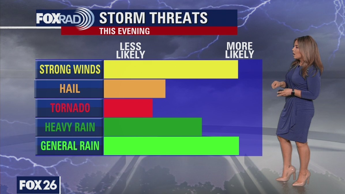
Strong to severe thunderstorms remain a concern through tonight across SE Texas. Damaging winds, hail, and heavy rain are the primary concerns. Once the rain wraps up, we'll finish up the week tomorrow with plenty of sunshine. Hot and humid conditions will settle in for the weekend, with highs close to record territory from Friday into early next week.
Strong to severe thunderstorms remain a concern through tonight across SE Texas. Damaging winds, hail, and heavy rain are the primary concerns. Once the rain wraps up, we'll finish up the week tomorrow with plenty of sunshine. Hot and humid conditions will settle in for the weekend, with highs close to record territory from Friday into early next week.
Severe weather arriving late afternoon, evening
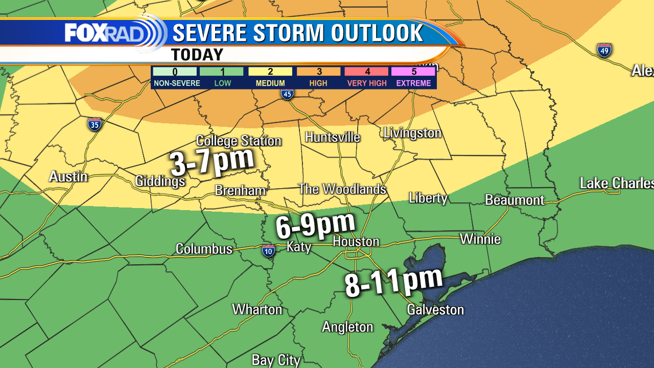
Our weather could get rocky by this evening with a line of strong to severe storms likely. The National Weather Service has our area under a medium risk for storms that could produce high winds or hail. The storms should move in from the northwest by late afternoon and affect the greater Houston area this evening. Following the rain, we'll have a brief cool-down followed by a heatwave bringing high temperatures to record territory from Friday through early next week.
Our weather could get rocky by this evening with a line of strong to severe storms likely. The National Weather Service has our area under a medium risk for storms that could produce high winds or hail. The storms should move in from the northwest by late afternoon and affect the greater Houston area this evening. Following the rain, we'll have a brief cool-down followed by a heatwave bringing high temperatures to record territory from Friday through early next week.
Thursday late afternoon weather forecast
Our weather could get rocky by this evening with a line of strong to severe storms likely. The National Weather Service has our area under a medium risk for storms that could produce high winds or hail. The storms should move in from the northwest by late afternoon and affect the greater Houston area this evening. Following the rain, we'll have a brief cool-down followed by a heat wave bringing high temperatures to record territory from Friday through early next week.
Our weather could get rocky by this evening with a line of strong to severe storms likely. The National Weather Service has our area under a medium risk for storms that could produce high winds or hail. The storms should move in from the northwest by late afternoon and affect the greater Houston area this evening. Following the rain, we'll have a brief cool-down followed by a heat wave bringing high temperatures to record territory from Friday through early next week.


Record-breaking heat in Texas brings potentially dangerous warmer overnight lows
As we brace for our first heat wave of the season, certain times of day and locations are warming faster than others. We take a look at why and how it can negatively affect you.
As we brace for our first heat wave of the season, certain times of day and locations are warming faster than others. We take a look at why and how it can negatively affect you.
Storms likely by Thursday evening
Our weather could get rocky by this evening with a line of strong to severe storms likely. The National Weather Service has our area under a medium risk for storms that could produce high winds or hail. The storms should move in from the northwest by late afternoon and affect the greater Houston area this evening. Following the rain, we'll have a brief cool-down followed by a heat wave bringing high temperatures to record territory from Friday through early next week.
Our weather could get rocky by this evening with a line of strong to severe storms likely. The National Weather Service has our area under a medium risk for storms that could produce high winds or hail. The storms should move in from the northwest by late afternoon and affect the greater Houston area this evening. Following the rain, we'll have a brief cool-down followed by a heat wave bringing high temperatures to record territory from Friday through early next week.
Thursday morning weather forecast
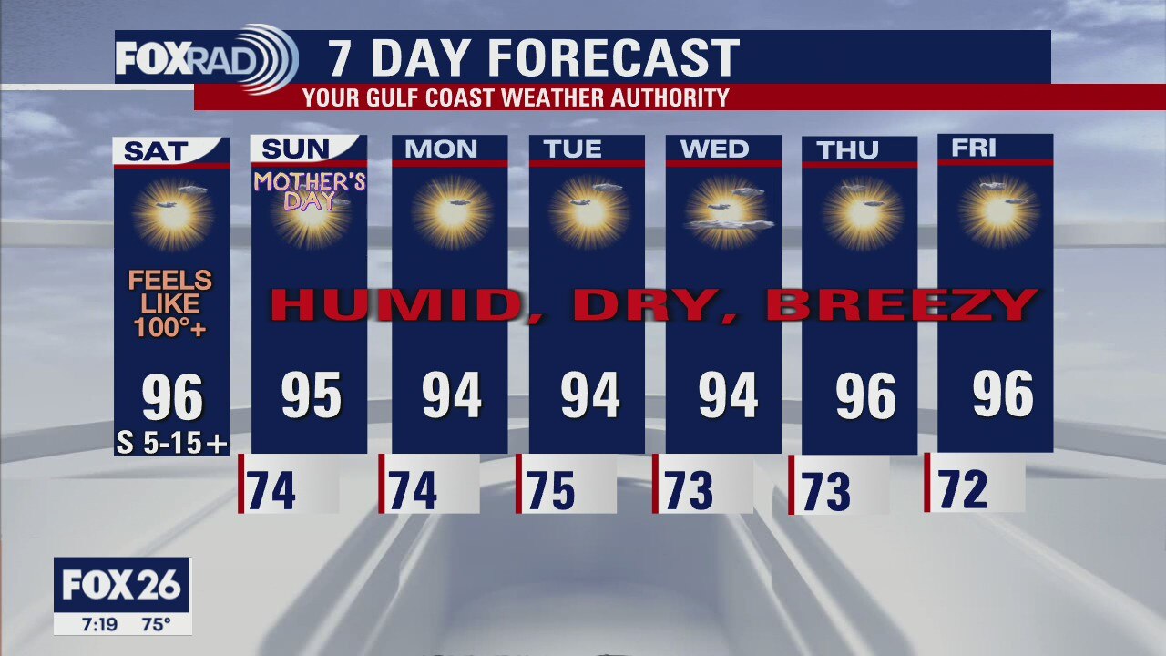
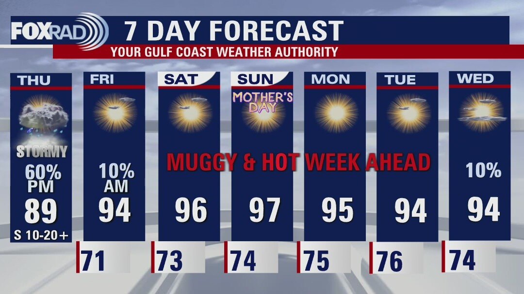
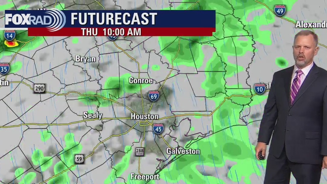
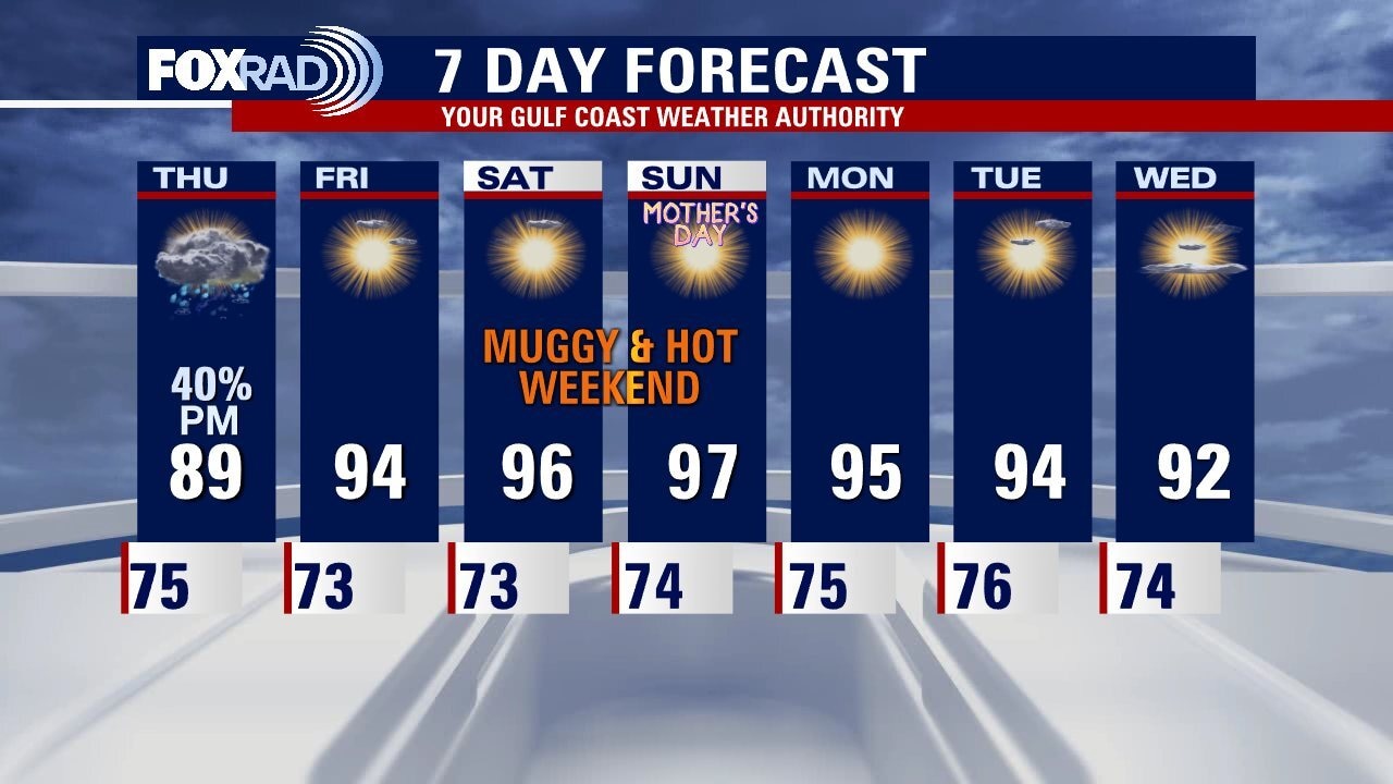
Warm again Thursday afternoon but a front will bring some showers and storms to Southeast Texas late in the day. Rain chances Thursday night are 80% after midnight. Record heat is expected for Houston this weekend. The "feels like" temps will be over 100 for Saturday and Sunday. Be safe if you are outdoors celebrating Mom this weekend!
Warm again Thursday afternoon but a front will bring some showers and storms to Southeast Texas late in the day. Rain chances Thursday night are 80% after midnight. Record heat is expected for Houston this weekend. The "feels like" temps will be over 100 for Saturday and Sunday. Be safe if you are outdoors celebrating Mom this weekend!

Wednesday evening weather forecast with Meteorologist John Dawson
Warm again Thursday afternoon but a front will bring some showers and storms to Southeast Texas late in the day. Rain chances Thursday night are 80% after midnight. Record heat is expected for Houston this weekend. The "feels like" temps will be over 100 for Saturday and Sunday. Be safe if you are outdoors celebrating Mom this weekend!
Warm again Thursday afternoon but a front will bring some showers and storms to Southeast Texas late in the day. Rain chances Thursday night are 80% after midnight. Record heat is expected for Houston this weekend. The "feels like" temps will be over 100 for Saturday and Sunday. Be safe if you are outdoors celebrating Mom this weekend!