


Where does Helene go after hitting Florida? Southeast, mid-Atlantic could see 'catastrophic' flooding
The large storm will move quickly north, bringing widespread heavy rain, damaging winds and possible tornadoes to major cities in the Southeast and Midwest, including Atlanta, Nashville and St. Louis.
The large storm will move quickly north, bringing widespread heavy rain, damaging winds and possible tornadoes to major cities in the Southeast and Midwest, including Atlanta, Nashville and St. Louis.


Flight disruptions impact Atlanta, Tampa as Hurricane Helene looms
The FOX Forecast Center expects the worst of the weather to be in the Atlanta metro from after midnight Friday morning through sunset.
The FOX Forecast Center expects the worst of the weather to be in the Atlanta metro from after midnight Friday morning through sunset.


Hurricane Helene could bring 'catastrophic' flooding to Southeast, mid-Atlantic
Hurricane Helene is forecast to make landfall along the Florida Big Bend on Thursday evening. It's also expected to impact major cities including Atlanta, Nashville and St. Louis.
Hurricane Helene is forecast to make landfall along the Florida Big Bend on Thursday evening. It's also expected to impact major cities including Atlanta, Nashville and St. Louis.
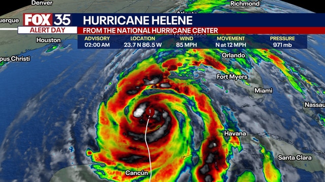

Live updates: Hurricane Helene forecast to hit Florida as Category 4 storm
Helene strengthened into a hurricane on Wednesday and is expected to strengthen further – potentially becoming a major hurricane – before making landfall over Florida on Thursday. Life-threatening storm surge, damaging winds, torrential rain, and flooding are possible.
Helene strengthened into a hurricane on Wednesday and is expected to strengthen further – potentially becoming a major hurricane – before making landfall over Florida on Thursday. Life-threatening storm surge, damaging winds, torrential rain, and flooding are possible.

Florida prepares for Hurricane Helene
FOX's Olivianna Calmes is in northern Florida with a look at how Floridians are preparing for Hurricane Helene to make an impact.
FOX's Olivianna Calmes is in northern Florida with a look at how Floridians are preparing for Hurricane Helene to make an impact.

Hurricane Helene moving closer to Florida | FOX 26 Tropical Weather Update
Helene is now a hurricane and expected to make landfall in Florida as a category 4 storm with 130+mph winds. Tropical Storm Warnings reach as far inland as Atlanta, Georgia as this powerful storm roars towards the Southeastern US.
Helene is now a hurricane and expected to make landfall in Florida as a category 4 storm with 130+mph winds. Tropical Storm Warnings reach as far inland as Atlanta, Georgia as this powerful storm roars towards the Southeastern US.


Where does Helene go after hitting Florida? Southeast, mid-Atlantic could see 'catastrophic' flooding
The large storm will bring widespread heavy rain, damaging wind and possible tornadoes to cities in the Southeast, including Atlanta and Asheville, North Carolina.
The large storm will bring widespread heavy rain, damaging wind and possible tornadoes to cities in the Southeast, including Atlanta and Asheville, North Carolina.


Hurricane Helene: Charlotte Motor Speedway to welcome evacuees
As Hurricane Helene approaches the U.S., the Charlotte Motor Speedway in North Carolina has opened its campgrounds to evacuees seeking shelter from the storm.
As Hurricane Helene approaches the U.S., the Charlotte Motor Speedway in North Carolina has opened its campgrounds to evacuees seeking shelter from the storm.


Live updates: Tropical Storm Helene nears hurricane strength in Caribbean on trek to Florida
Tropical Storm Helene is nearing hurricane strength just offshore of the northeastern coast of the Yucatan Peninsula toward the Gulf of Mexico, according to the National Hurricane Center (NHC). It's expected to become a major hurricane (Category 3 or higher) before making landfall in Florida's Big Bend region on Thursday.
Tropical Storm Helene is nearing hurricane strength just offshore of the northeastern coast of the Yucatan Peninsula toward the Gulf of Mexico, according to the National Hurricane Center (NHC). It's expected to become a major hurricane (Category 3 or higher) before making landfall in Florida's Big Bend region on Thursday.

Tropical Storm Helene forms, moving towards Florida
Helene is officially in the Caribbean with tropical storm force winds. But this cyclone will intensify quickly into a hurricane and make its way towards Florida.
Helene is officially in the Caribbean with tropical storm force winds. But this cyclone will intensify quickly into a hurricane and make its way towards Florida.


Florida storm live updates: Watches expand as Potential Tropical Cyclone Nine expected to strengthen
Potential Tropical Cyclone Nine formed in the northwestern Caribbean Sea on Monday morning and is forecast to become a hurricane later this week, according to the National Hurricane Center (NHC).
Potential Tropical Cyclone Nine formed in the northwestern Caribbean Sea on Monday morning and is forecast to become a hurricane later this week, according to the National Hurricane Center (NHC).

Monitoring Potential Tropical Cyclone Nine | FOX 26 Tropical Weather Forecast
Potential Tropical Cyclone Nine is brewing in the Caribbean. The current forecast now calls for a major hurricane at landfall somewhere in the Southeast US.
Potential Tropical Cyclone Nine is brewing in the Caribbean. The current forecast now calls for a major hurricane at landfall somewhere in the Southeast US.

Bridgford Foods | Hurricane Gear Test
With hurricane season still going strong, Meteorologist John Dawson's gear test focuses on emergency food options that are both budget-friendly and long-lasting.
With hurricane season still going strong, Meteorologist John Dawson's gear test focuses on emergency food options that are both budget-friendly and long-lasting.

Watching for Gulf of Mexico development in the tropics | FOX 26 Tropical Weather Forecast
Invest 97L continues to brew in the Caribbean as confidences grows that this system will become Hurricane Helene in the Gulf of Mexico. Still some questions on where in the Gulf this storm will head at the end of this upcoming week.
Invest 97L continues to brew in the Caribbean as confidences grows that this system will become Hurricane Helene in the Gulf of Mexico. Still some questions on where in the Gulf this storm will head at the end of this upcoming week.

Possible tropical cyclone development in Caribbean
All eyes are still on the Northwest Caribbean for possible tropical cyclone development, but it is going to take several more days for anything to show up. Models are starting to agree a little bit on the general direction of the potential system.
All eyes are still on the Northwest Caribbean for possible tropical cyclone development, but it is going to take several more days for anything to show up. Models are starting to agree a little bit on the general direction of the potential system.

Potential tropical development possible next week in the Gulf of Mexico | FOX 26 Tropical Weather Forecast
Chance for potential tropical development has increased to 50% for the NW Caribbean and Southern Gulf of Mexico over the next seven days. That means we should be alert for a possible tropical system in the Gulf, especially mid-late next week. Models are not certain exactly where this system will track yet so keep checking back for updates! Two other disturbances in the Atlantic, Invest 96-L and the remnants of Gordon are unlikely to develop into tropical systems. Environmental conditions appear unfavorable and chances have dropped to 10%.
Chance for potential tropical development has increased to 50% for the NW Caribbean and Southern Gulf of Mexico over the next seven days. That means we should be alert for a possible tropical system in the Gulf, especially mid-late next week. Models are not certain exactly where this system will track yet so keep checking back for updates! Two other disturbances in the Atlantic, Invest 96-L and the remnants of Gordon are unlikely to develop into tropical systems. Environmental conditions appear unfavorable and chances have dropped to 10%.

Three potential areas of development in Atlantic
We are still monitoring three areas across the Atlantic basin with the potential for tropical cyclone development. An area of low pressure could form in the NW Caribbean and push into the southern Gulf of Mexico over the next week. Chances have increased to 40% over the next 7 days. Models are still torn as to whether it would move closer to Mexico, Houston or Florida so keep checking back for updates. Disorganized low pressure in the west-central Atlantic has a low 20% chance for development over the next week. The remnants of Gordon in the central Atlantic are expected to drift north and stay away from land. But there's a 30% chance Gordon could turn back into a tropical system.
We are still monitoring three areas across the Atlantic basin with the potential for tropical cyclone development. An area of low pressure could form in the NW Caribbean and push into the southern Gulf of Mexico over the next week. Chances have increased to 40% over the next 7 days. Models are still torn as to whether it would move closer to Mexico, Houston or Florida so keep checking back for updates. Disorganized low pressure in the west-central Atlantic has a low 20% chance for development over the next week. The remnants of Gordon in the central Atlantic are expected to drift north and stay away from land. But there's a 30% chance Gordon could turn back into a tropical system.

Caribbean Sea being watched for development
Remnants of Gordon remain weak and disorganized in the Central Atlantic. As this disturbance drifts north over the next few days, there's a LOW 30% chance of tropical development. Chance increases to a MEDIUM 60% chance for a tropical storm to redevelop over the next week. But this system is expected to remain over water. Another area in the NW Caribbean Sea is being monitored for long-term development over the next several days. There's a LOW 20% chance a tropical system could form near the Yucatan Peninsula and push into the Gulf of Mexico over the next 7 days. Stay up to date on weather where you live with the free FOX Local app!
Remnants of Gordon remain weak and disorganized in the Central Atlantic. As this disturbance drifts north over the next few days, there's a LOW 30% chance of tropical development. Chance increases to a MEDIUM 60% chance for a tropical storm to redevelop over the next week. But this system is expected to remain over water. Another area in the NW Caribbean Sea is being monitored for long-term development over the next several days. There's a LOW 20% chance a tropical system could form near the Yucatan Peninsula and push into the Gulf of Mexico over the next 7 days. Stay up to date on weather where you live with the free FOX Local app!

Potential Tropical Cyclone Eight brings heavy rain
What used to be Potential Tropical Cyclone Eight continues to bring rounds of heavy rain to parts of the Carolinas. Close to 20" has fallen in parts of North Carolina around Carolina Beach. The only other system being monitored now is in the central Atlantic. The remnants of Gordon remain disorganized with no threat to land. There's a low 20% chance for Gordon to return to bring a tropical system over the next two days. There's a MEDIUM 40% chance for redevelopment over the next 7 days.
What used to be Potential Tropical Cyclone Eight continues to bring rounds of heavy rain to parts of the Carolinas. Close to 20" has fallen in parts of North Carolina around Carolina Beach. The only other system being monitored now is in the central Atlantic. The remnants of Gordon remain disorganized with no threat to land. There's a low 20% chance for Gordon to return to bring a tropical system over the next two days. There's a MEDIUM 40% chance for redevelopment over the next 7 days.

Watching Potential Tropical Cyclone 8, Gordon | FOX 26 Tropical Weather Forecast
Potential Tropical Cyclone Eight is no longer expected to become Tropical Storm Helene because it is already moving inland along the Carolina coast. It will still bring a big flood threat to the Carolinas over the next few days and could produce a few tornadoes. 4-8" of rain will be possible with isolated 10" totals. The other system being monitored is Gordon which remains a fairly disorganized Tropical depression. Gordon is in the central Atlantic and should not be a threat to land.
Potential Tropical Cyclone Eight is no longer expected to become Tropical Storm Helene because it is already moving inland along the Carolina coast. It will still bring a big flood threat to the Carolinas over the next few days and could produce a few tornadoes. 4-8" of rain will be possible with isolated 10" totals. The other system being monitored is Gordon which remains a fairly disorganized Tropical depression. Gordon is in the central Atlantic and should not be a threat to land.