

Cold front bringing chilly temps, wind advisory expected this weekend in SE Texas
Saturday weather forecast with Meteorologist Lena Maria Arango
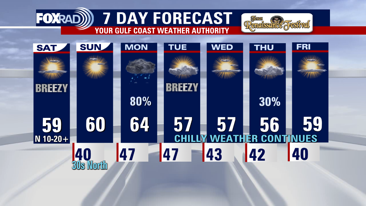
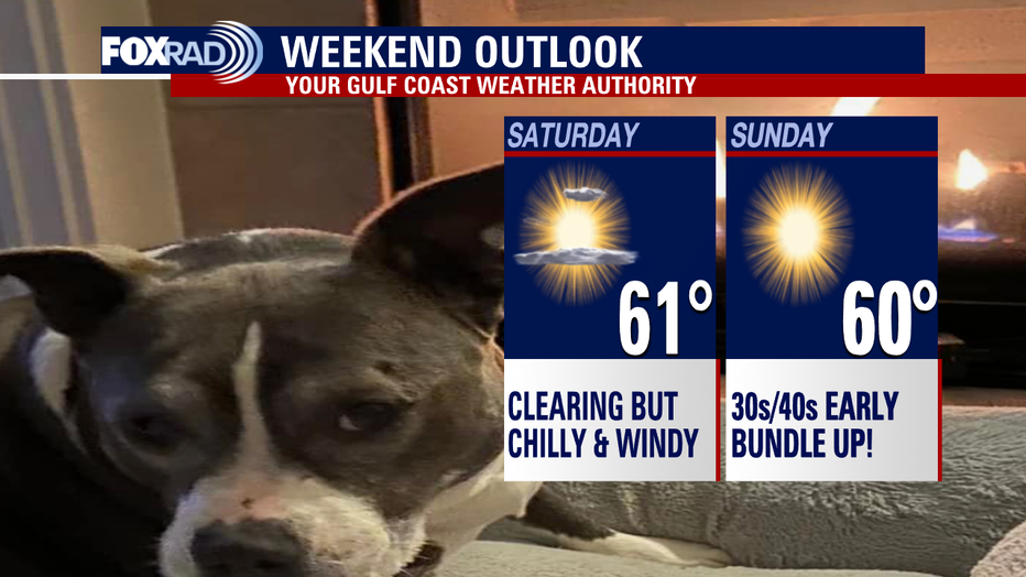
We're in for a chilly, but dry weekend. Sunday will be less breezy, but there is a freeze watch in effect overnight for our far northern counties where temperatures may dip to, or slightly below 32°. Take proper precautions to protect the 4 p's! On Monday, two systems will converge - an incoming trough from the northwest and a developing coastal low. That's going to lead to a raw and rainy start to the work week, with a couple of isolated storms and downpours in the mix. Past that, things get a little fuzzy on the specifics of our next rain chance so check back for updates and changes. The one thing that is for certain, is that our cold pattern will be staying in place for now.
HOUSTON - It's been a really warm week by November standards all across southeast Texas.
We have been close to record high temperatures for multiple days this week with temperatures in the 80s. We even managed to warm to 82 degrees on Friday at Houston Bush Intercontinental Airport, which was 5 degrees shy of our record high of 87 set back in 1978.
However, thanks to a cold front, we are in the process of going from near-record heat to temps running about 10-20 degrees below normal.
SUGGESTED: Program helps veterans with credit counseling to avoid homelessness
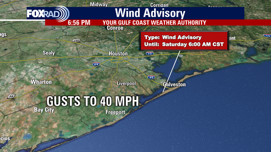
A strong cold front is pushing in, bringing some rain Friday evening. The showers will exit early Saturday, but windy and chilly conditions will impact your weekend plans.

We'll start off in the 40s Saturday and only climb to around 60 degrees. With the wind out of the north at 10-20 mph, wind chills will be in the 30s early Saturday.
COMMUNITY: Texas City community joins together to support young boy with stage 3 cancer
In fact, winds could gust close to 40 mph Saturday along the coast and a Wind Advisory is in effect until 6 a.m. that includes Galveston Island and the Bolivar Peninsula.
Sunday morning looks even colder with some inland locations like Conroe dipping to the 30s, so bundle up! The last time we were in the 30s at Bush Intercontinental Airport was way back on March 13.
SUPPORTING VETERANS: 'Make Camo Your Cause': How you can help this Veterans Day and beyond
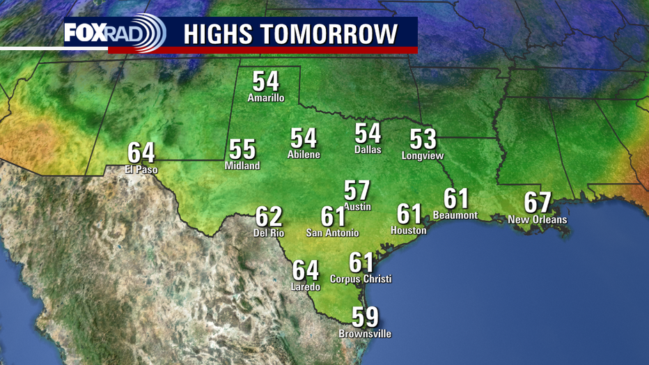
With some sunshine, temperatures should rebound back to nearly 60 degrees Sunday afternoon. Houston's average high is in the mid-70s and its average low is in the low 50s. So this is certainly cooler than the norm.
The cold spell will stick around for at least a week so crank up the heat, grab the jackets or hang out by the fireplace!
This weather will certainly get you into the holiday spirit with Thanksgiving and Christmas right around the corner. Have a great weekend!