

Tropical weather update - November 8, 2025
Tropical cyclone activity is not expected in the Atlantic Basin during the next 7 days. Hurricane season lasts until November 30th. Any chance for additional tropical activity for the Gulf looks extremely low.
Tropical cyclone activity is not expected in the Atlantic Basin during the next 7 days. Hurricane season lasts until November 30th. Any chance for additional tropical activity for the Gulf looks extremely low.


Houston weather: Near record highs Saturday, cold to start the work week
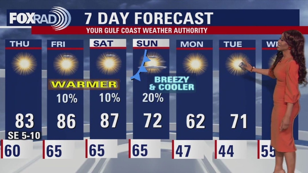
Houston weather will feel like a roller coaster this week with near-record highs on Saturday and cooler, windy weather to end the weekend and start the work week.
Houston weather will feel like a roller coaster this week with near-record highs on Saturday and cooler, windy weather to end the weekend and start the work week.
Houston weather: Nov. 8 Morning forecast
Temperatures could reach near-record highs Saturday, but that won't last long as much cooler temperatures move into the area to start the week. How much of a cooldown will we see? FOX 26 meteorologist Peyton Galyean has the details.
Temperatures could reach near-record highs Saturday, but that won't last long as much cooler temperatures move into the area to start the week. How much of a cooldown will we see? FOX 26 meteorologist Peyton Galyean has the details.
Houston weather: Unseasonably warm day for Saturday
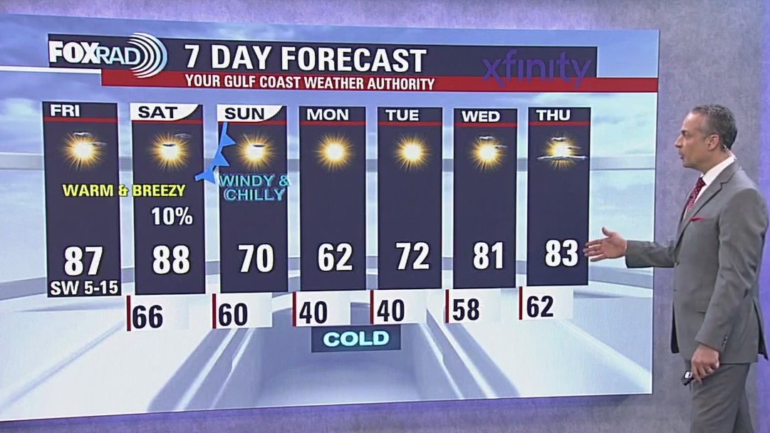
Temperatures soared to near record levels in Houston on Friday climbing to the middle to upper 80s. That trend continues Saturday with afternoon highs that could come close to record levels. Winds will increase a bit - coming in from the southwest around 5-15 mph. Patchy fog is possible again on Friday night.
Temperatures soared to near record levels in Houston on Friday climbing to the middle to upper 80s. That trend continues Saturday with afternoon highs that could come close to record levels. Winds will increase a bit - coming in from the southwest around 5-15 mph. Patchy fog is possible again on Friday night.
Extreme temperature swings in Houston coming | Forecasting With Friends
Join the FOX 26 Weather Team as we talk all things weather on our newest show!
Join the FOX 26 Weather Team as we talk all things weather on our newest show!


Houston weather forecast: Warm Friday, Saturday ahead of next cold front
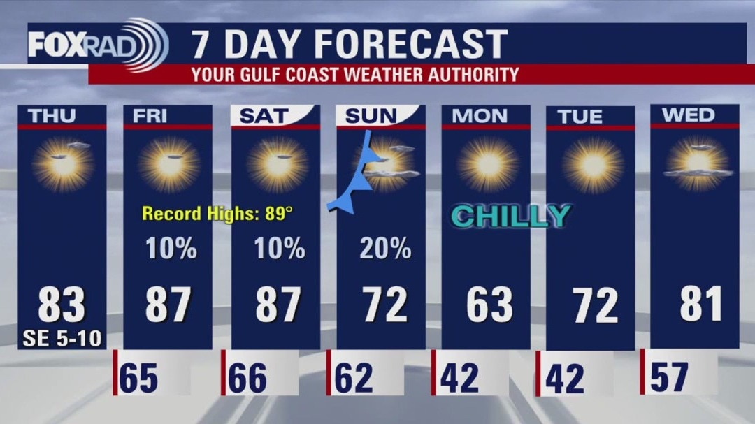
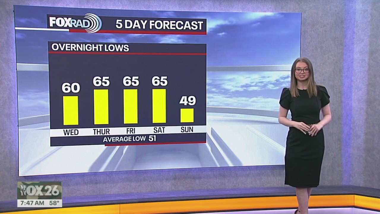
Starting Sunday night and into Monday, the air turns much cooler. Overnight lows will dip into the low 40s with upper 30s north of Houston.
Starting Sunday night and into Monday, the air turns much cooler. Overnight lows will dip into the low 40s with upper 30s north of Houston.
Houston weather forecast for Nov. 7, 2025
A dense fog advisory is in effect until 9 a.m., then a very warm day with highs in the mid to upper 80s.
A dense fog advisory is in effect until 9 a.m., then a very warm day with highs in the mid to upper 80s.
Houston weather: Unseasonably warm day ahead for Friday
Get ready for a very toasty end to the week with afternoon sun and highs hitting the mid-to-upper 80s. This warm, humid air mass has been setting the stage for patchy fog to develop overnight and linger into the morning hours through early Saturday. Don't be surprised if visibility is low for the morning commute again, but the afternoons on Friday and Saturday will be close to the record highs of 89 degrees in Houston.
Get ready for a very toasty end to the week with afternoon sun and highs hitting the mid-to-upper 80s. This warm, humid air mass has been setting the stage for patchy fog to develop overnight and linger into the morning hours through early Saturday. Don't be surprised if visibility is low for the morning commute again, but the afternoons on Friday and Saturday will be close to the record highs of 89 degrees in Houston.

Houston weather: Warm weather for your Friday
Get ready for a very toasty end to the week with afternoon sun and highs hitting the mid-to-upper 80s. This warm, humid air mass has been setting the stage for patchy fog to develop overnight and linger into the morning hours through early Saturday. Don't be surprised if visibility is low for the morning commute again, but the afternoons on Friday and Saturday will be close to the record highs of 89 degrees in Houston.
Get ready for a very toasty end to the week with afternoon sun and highs hitting the mid-to-upper 80s. This warm, humid air mass has been setting the stage for patchy fog to develop overnight and linger into the morning hours through early Saturday. Don't be surprised if visibility is low for the morning commute again, but the afternoons on Friday and Saturday will be close to the record highs of 89 degrees in Houston.
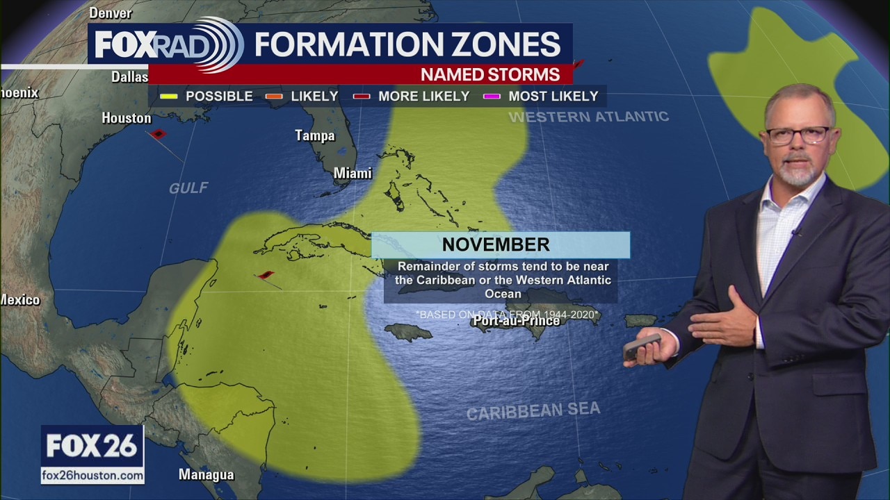
Tropical Weather Forecast - November 6, 2025
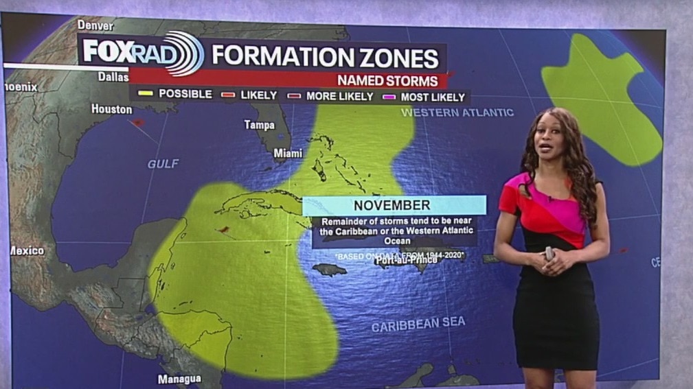
So far this season, we have had 13 named storms, 5 hurricanes and four major hurricanes. Tropical cyclone activity is not expected in the Atlantic Basin during the next 7 days. Hurricane season lasts until November 30th. Any chance for additional tropical activity for the Gulf for the rest of this month is extremely low. The one area to watch with at least a slight chance for development would be the Western portion of the Caribbean. But even there, chances are very low. Overall activity is winding down as the season gets closer to ending.
So far this season, we have had 13 named storms, 5 hurricanes and four major hurricanes. Tropical cyclone activity is not expected in the Atlantic Basin during the next 7 days. Hurricane season lasts until November 30th. Any chance for additional tropical activity for the Gulf for the rest of this month is extremely low. The one area to watch with at least a slight chance for development would be the Western portion of the Caribbean. But even there, chances are very low. Overall activity is winding down as the season gets closer to ending.


Houston weather: Unseasonably warm day on the way for Friday
Much warmer weather is coming to the Houston area for your Friday before a temperature roller coaster this weekend!
Much warmer weather is coming to the Houston area for your Friday before a temperature roller coaster this weekend!

Atmospheric river on West Coast | Forecasting With Friends
Join the FOX 26 Weather Team as we talk all things weather.
Join the FOX 26 Weather Team as we talk all things weather.


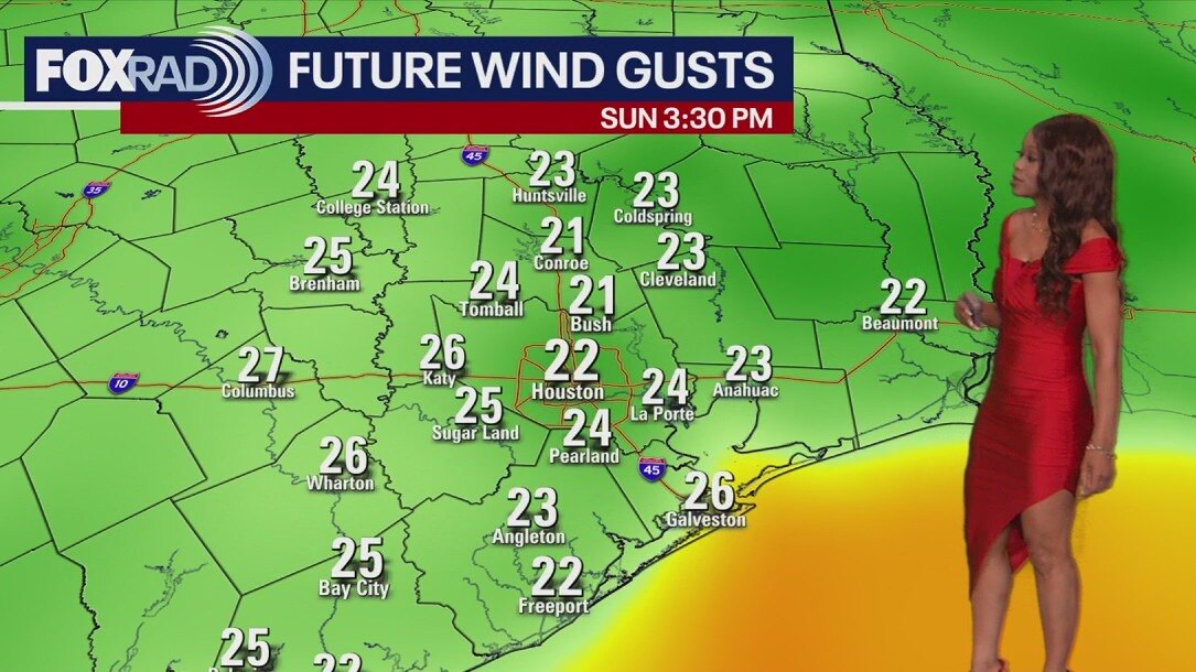
Houston weather: Fog, warm days ahead of next cold front
The unseasonably warm weather will come to an abrupt end this weekend. A strong cold front is slated to push through late Saturday evening or overnight, leading to a dramatic temperature swing.
The unseasonably warm weather will come to an abrupt end this weekend. A strong cold front is slated to push through late Saturday evening or overnight, leading to a dramatic temperature swing.
Houston weather forecast for Nov. 6, 2025
Get ready for a very warm end to the week with afternoon sun and highs hitting the mid-to-upper 80s. This warm, humid air mass has been setting the stage for patchy fog to develop overnight and linger into the morning hours through early Saturday. Don't be surprised if visibility is low for the morning commute again, but the afternoons on Friday and Saturday will be close to the record highs of 89 degrees in Houston.
Get ready for a very warm end to the week with afternoon sun and highs hitting the mid-to-upper 80s. This warm, humid air mass has been setting the stage for patchy fog to develop overnight and linger into the morning hours through early Saturday. Don't be surprised if visibility is low for the morning commute again, but the afternoons on Friday and Saturday will be close to the record highs of 89 degrees in Houston.

Houston weather: Another beautiful day ahead for Thursday
A Gulf breeze has returned which is playing a major role in our gradual warming trend. Afternoon highs for the rest of the week will get progressively warmer with upper 80s for some by Friday and Saturday. Overnight lows will also get milder with low to mid 60s for the rest of the week. With increasing humidity, there will be a slight chance for isolated showers along the coast.
A Gulf breeze has returned which is playing a major role in our gradual warming trend. Afternoon highs for the rest of the week will get progressively warmer with upper 80s for some by Friday and Saturday. Overnight lows will also get milder with low to mid 60s for the rest of the week. With increasing humidity, there will be a slight chance for isolated showers along the coast.
Houston weather: November 5 evening forecast
Look for even more humidity by the end of the week with temperatures soaring closer to 90°.
Look for even more humidity by the end of the week with temperatures soaring closer to 90°.


Houston weather: More sunshine ahead for your Thursday
Another day full of sunshine is on tap for your Thursday in the Houston area.
Another day full of sunshine is on tap for your Thursday in the Houston area.
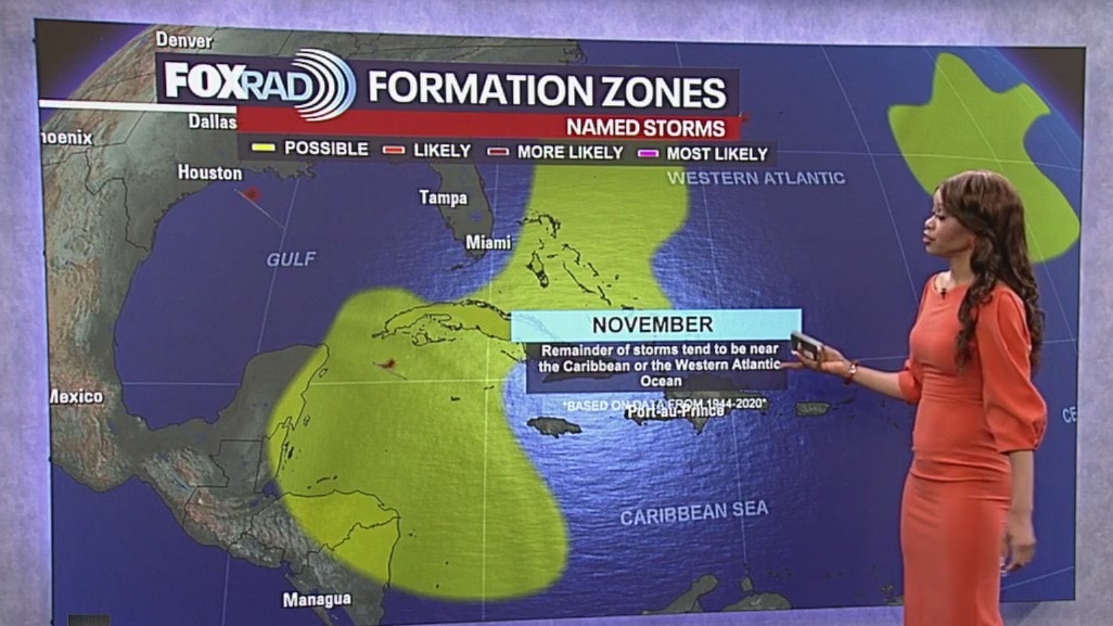
Tropical Weather Forecast: Tropics calm for now
Tropical cyclone activity is not expected in the Atlantic Basin during the next 7 days. Hurricane season lasts until November 30th. Any chance for additional tropical activity for the Gulf for the rest of this month is extremely low. The one area to watch with at least a slight chance for development would be the Western portion of the Caribbean. But even there, chances are very low. Overall activity is winding down as the season gets closer to ending.
Tropical cyclone activity is not expected in the Atlantic Basin during the next 7 days. Hurricane season lasts until November 30th. Any chance for additional tropical activity for the Gulf for the rest of this month is extremely low. The one area to watch with at least a slight chance for development would be the Western portion of the Caribbean. But even there, chances are very low. Overall activity is winding down as the season gets closer to ending.


Houston weather: Beautiful Wednesday; tracking our next cold front
A Gulf breeze has returned today which will usher in a gradual warming trend. A cold front is expected this weekend that will dry us out and lower our temperatures.
A Gulf breeze has returned today which will usher in a gradual warming trend. A cold front is expected this weekend that will dry us out and lower our temperatures.
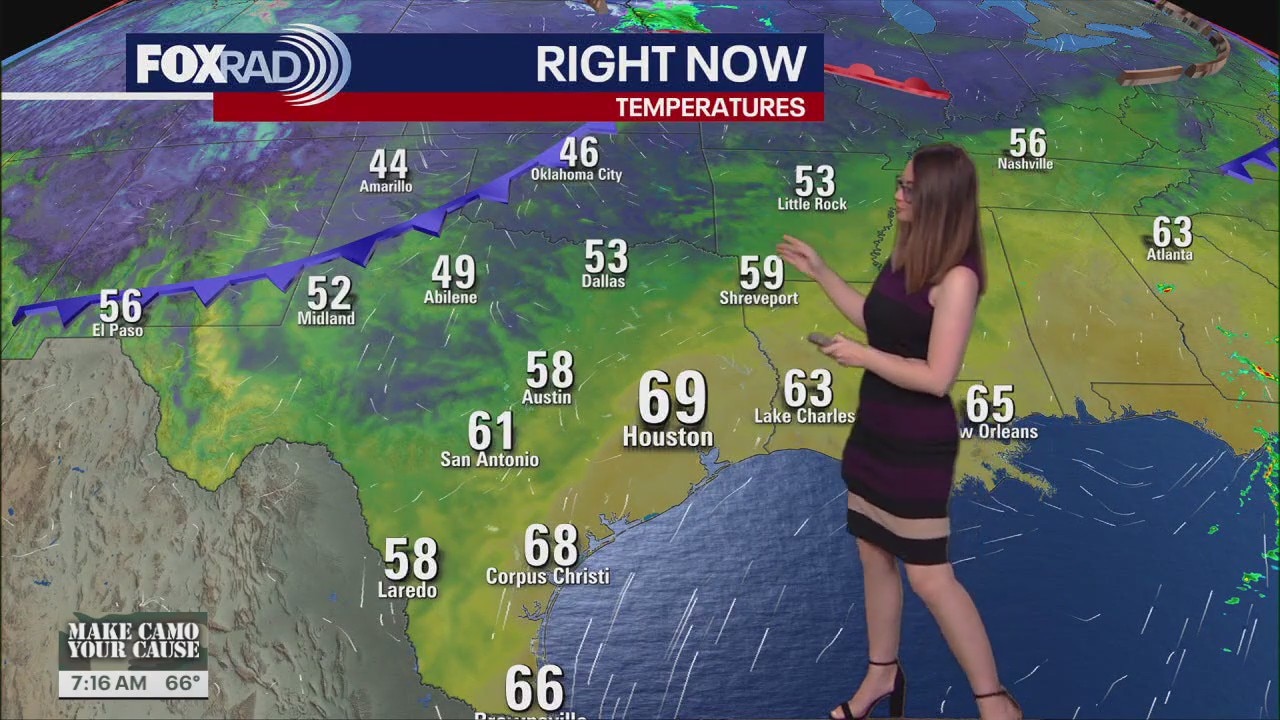
Houston weather forecast for Nov. 5, 2025
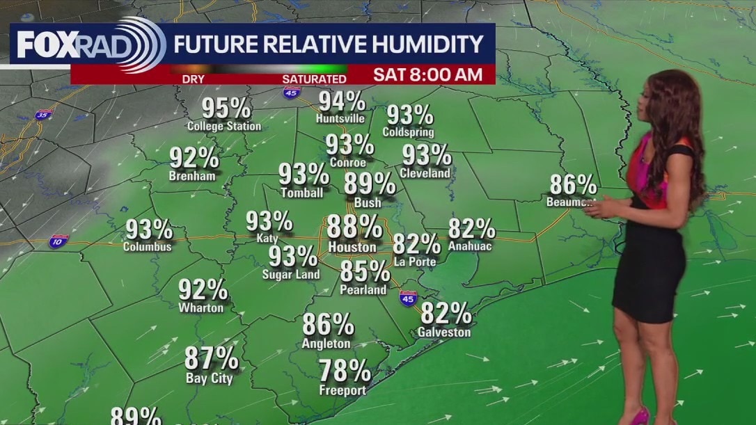
Another spectacular day is expected today. Temperatures ranging from the upper 70s and lower end 80s, calm winds, but it is muggy. Relative Humidity values stay persistent throughout morning, evening, and overnight hours. We are tracking a front this weekend that will likely wipe out much of this moisture.
Another spectacular day is expected today. Temperatures ranging from the upper 70s and lower end 80s, calm winds, but it is muggy. Relative Humidity values stay persistent throughout morning, evening, and overnight hours. We are tracking a front this weekend that will likely wipe out much of this moisture.