

Friday weather forecast for Houston
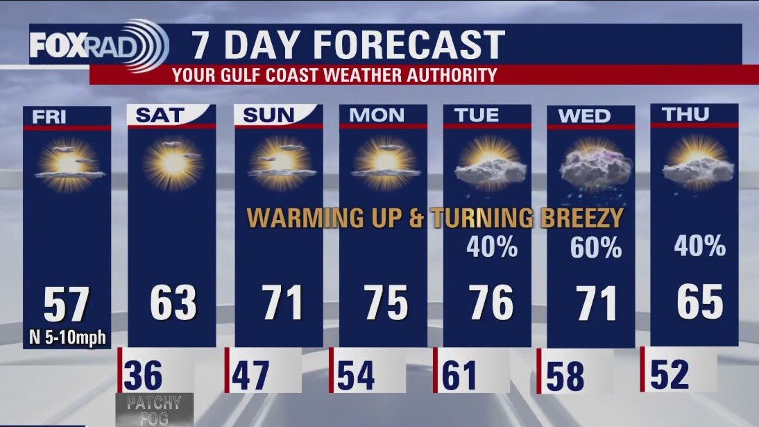
Sunshine makes a roaring return to the forecast, with steadily improving temps each day. Tomorrow morning will be chilly again, with some outlying locations likely near the freezing mark and even a little bit of patchy freezing fog possible. Afternoons will be glorious with several 70+ days, the forecast turns breezy & unsettled toward the tail end of the 7-day.
Sunshine makes a roaring return to the forecast, with steadily improving temps each day. Tomorrow morning will be chilly again, with some outlying locations likely near the freezing mark and even a little bit of patchy freezing fog possible. Afternoons will be glorious with several 70+ days, the forecast turns breezy & unsettled toward the tail end of the 7-day.

Texas power outages linger as New England girds for deep freeze
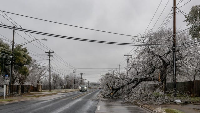
Hundreds of thousands were still without power across Texas on Friday morning after winter storms. Austin officials compared damage from fallen trees and iced-over power lines to tornadoes.
Hundreds of thousands were still without power across Texas on Friday morning after winter storms. Austin officials compared damage from fallen trees and iced-over power lines to tornadoes.
Friday weather forecast for Houston
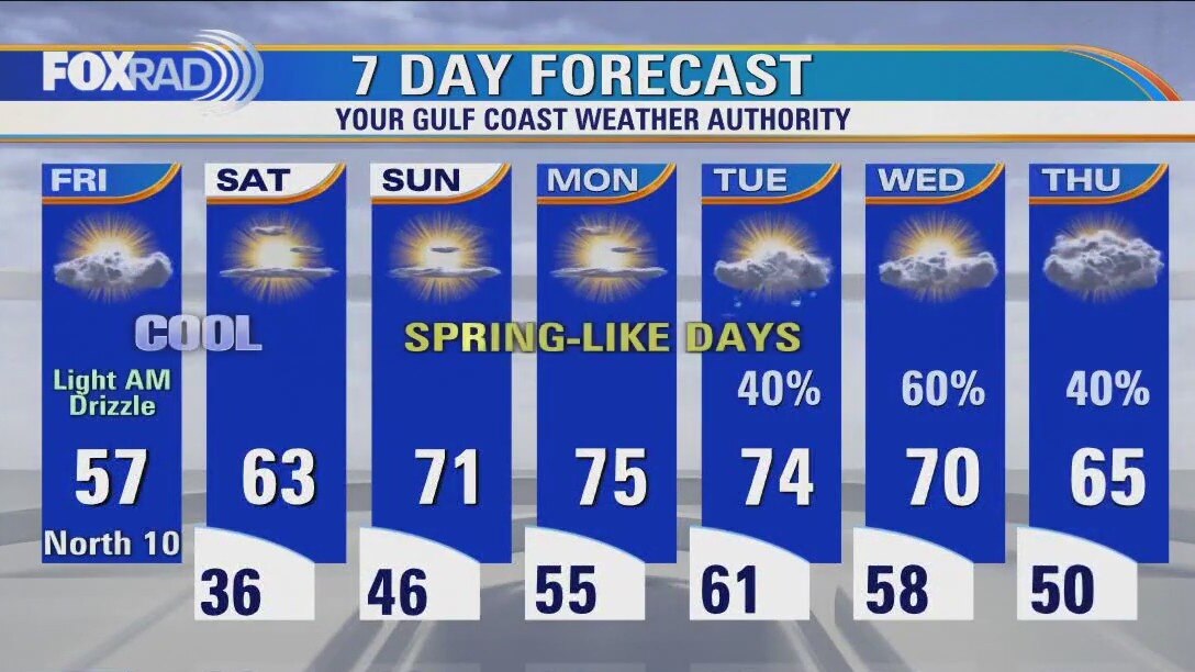
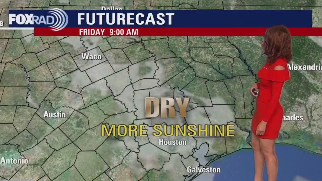
Cold and breezy this morning, then partly cloudy, cool and dry with highs in the mid 50s.
Cold and breezy this morning, then partly cloudy, cool and dry with highs in the mid 50s.
Friday morning Houston-area weather forecast
A change is coming! And we could sure use it after a cloudy, cold and at times wet week so far. Look for some clouds, fog and drizzle to stick around tonight with temperatures dipping to the middle to upper 30s. No ice is expect tonight. Plan on some icy roads still possible if your travels take you over towards Austin or up towards Dallas. Pattern shift kicks into high gear for SE Texas Friday through the weekend with sunshine and warmer temps. We should climb to near 60 by Friday afternoon with temperatures soaring to the low 70s by Sunday. Warmth will extend through the middle of next week with a chance for showers by Tuesday and Wednesday. Make plans outdoors for the weekend since Houston will have phenomenal weather!
A change is coming! And we could sure use it after a cloudy, cold and at times wet week so far. Look for some clouds, fog and drizzle to stick around tonight with temperatures dipping to the middle to upper 30s. No ice is expect tonight. Plan on some icy roads still possible if your travels take you over towards Austin or up towards Dallas. Pattern shift kicks into high gear for SE Texas Friday through the weekend with sunshine and warmer temps. We should climb to near 60 by Friday afternoon with temperatures soaring to the low 70s by Sunday. Warmth will extend through the middle of next week with a chance for showers by Tuesday and Wednesday. Make plans outdoors for the weekend since Houston will have phenomenal weather!
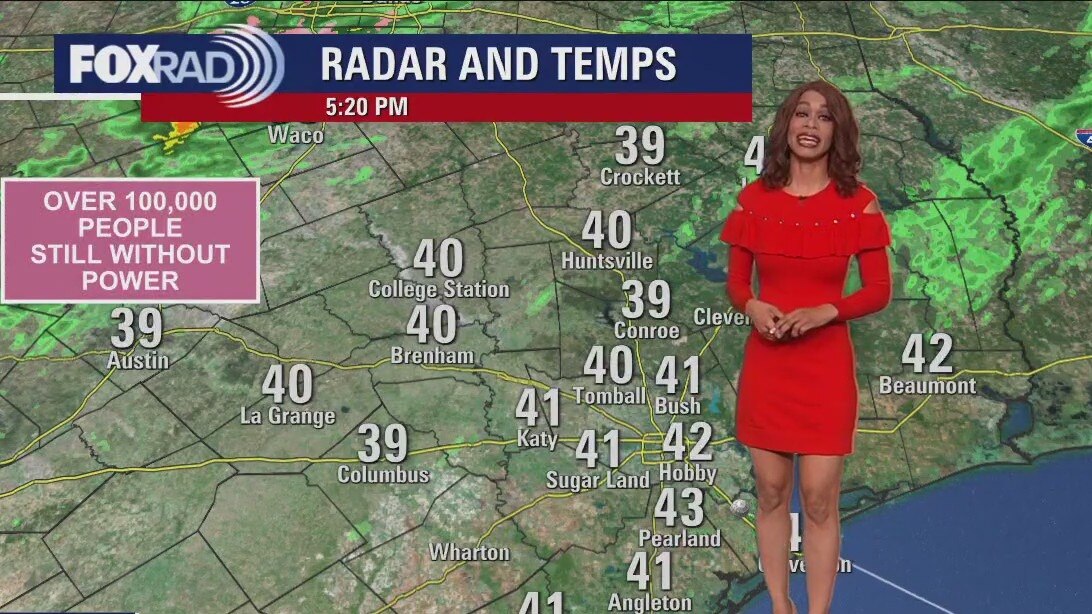
Chilly temps in the 40s Thursday evening
A change is coming! And we could sure use it after a cloudy, cold and at times wet week so far. Look for some clouds, fog and drizzle to stick around tonight with temperatures dipping to the middle to upper 30s. No ice is expect tonight. Plan on some icy roads still possible if your travels take you over towards Austin or up towards Dallas. Pattern shift kicks into high gear for SE Texas Friday through the weekend with sunshine and warmer temps. We should climb to near 60 by Friday afternoon with temperatures soaring to the low 70s by Sunday. Warmth will extend through the middle of next week with a chance for showers by Tuesday and Wednesday. Make plans outdoors for the weekend since Houston will have phenomenal weather!
A change is coming! And we could sure use it after a cloudy, cold and at times wet week so far. Look for some clouds, fog and drizzle to stick around tonight with temperatures dipping to the middle to upper 30s. No ice is expect tonight. Plan on some icy roads still possible if your travels take you over towards Austin or up towards Dallas. Pattern shift kicks into high gear for SE Texas Friday through the weekend with sunshine and warmer temps. We should climb to near 60 by Friday afternoon with temperatures soaring to the low 70s by Sunday. Warmth will extend through the middle of next week with a chance for showers by Tuesday and Wednesday. Make plans outdoors for the weekend since Houston will have phenomenal weather!

El Tiempo 2 de febrero de 2023
FOX26 Meteor?loga Lena Maria Arango tiene su pron?stico para el fin de semana.
FOX26 Meteor?loga Lena Maria Arango tiene su pron?stico para el fin de semana.
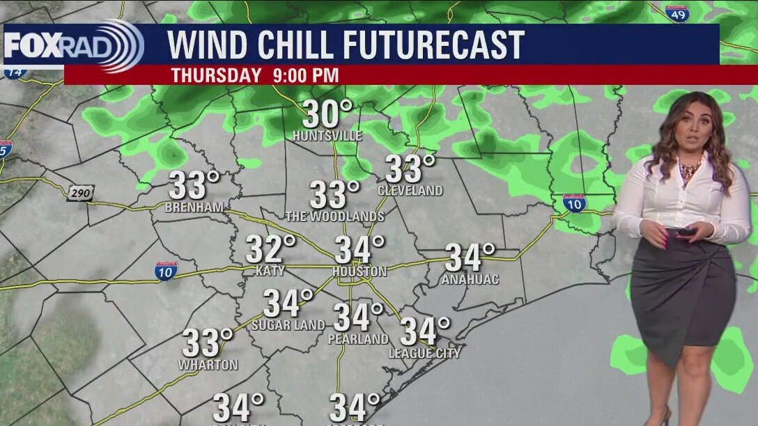
Chilly, cloudy Thursday afternoon in the 40s
Get ready for improvements! Rain chances will continue to drop throughout the rest of today but we'll stay cloudy through tomorrow morning. Clouds decrease throughout the day Friday but chilly temps, especially in the mornings will linger. Wind chills could get down into the 20s in outlying areas Friday + Saturday mornings so layer up! Good news is, we can bask in the glory of several dry, sunny warmer days over the weekend and into the start of next week. Bad news is, the forecast looks to turn messy again starting on Tuesday.
Get ready for improvements! Rain chances will continue to drop throughout the rest of today but we'll stay cloudy through tomorrow morning. Clouds decrease throughout the day Friday but chilly temps, especially in the mornings will linger. Wind chills could get down into the 20s in outlying areas Friday + Saturday mornings so layer up! Good news is, we can bask in the glory of several dry, sunny warmer days over the weekend and into the start of next week. Bad news is, the forecast looks to turn messy again starting on Tuesday.


Groundhog Day 2023: Punxsutawney Phil sees shadow, predicts 6 more weeks of winter
"No matter how you measure, it’s six more weeks of winter weather," Punxsutawney Phil's handlers read aloud from a scroll early Thursday.
"No matter how you measure, it’s six more weeks of winter weather," Punxsutawney Phil's handlers read aloud from a scroll early Thursday.
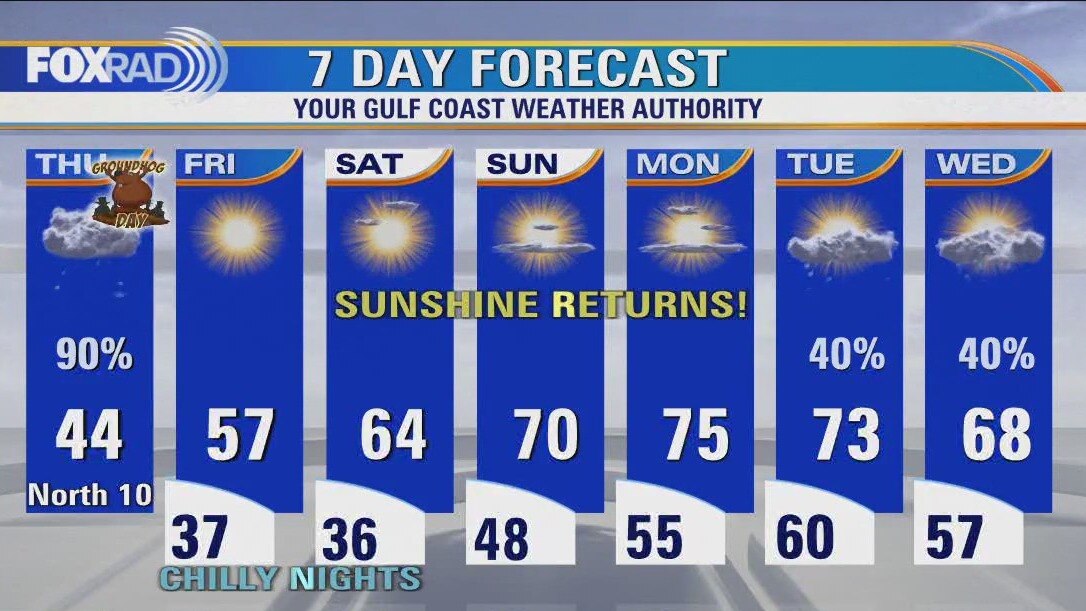
Houston weather: Cold and wet again on Thursday
Today will be cold and wet again, but we have much nicer weather on the way. Expect an overcast, showery day today with temperatures stuck in the low 40s for most of the day. Rain should move out of the area late this afternoon as we turn the corner toward a clear pattern Friday through Monday. This weekend is shaping up to be a beauty with sunny days bringing highs in the 60s on Saturday and low 70s on Sunday. Rain could return by Tuesday.
Today will be cold and wet again, but we have much nicer weather on the way. Expect an overcast, showery day today with temperatures stuck in the low 40s for most of the day. Rain should move out of the area late this afternoon as we turn the corner toward a clear pattern Friday through Monday. This weekend is shaping up to be a beauty with sunny days bringing highs in the 60s on Saturday and low 70s on Sunday. Rain could return by Tuesday.
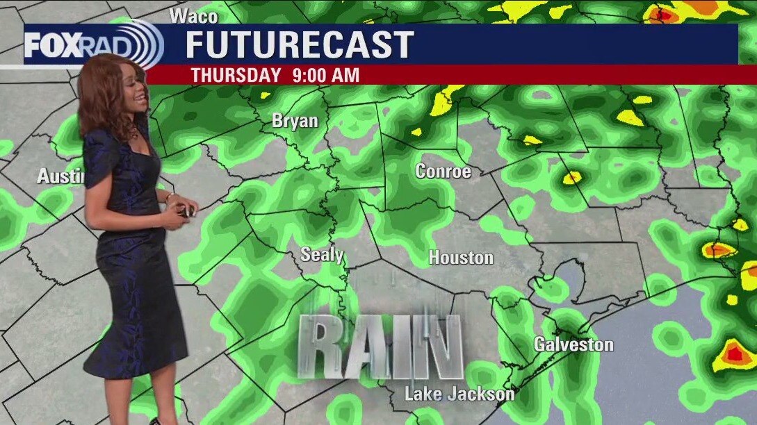
Thursday morning Houston-area weather forecast
Isolated light icing is still possible NW of Houston up around Washington county where a Winter Weather Advisory has been extended until 6 AM Thursday. Major issues are not expected, but a few icy spots might develop on bridges, sidewalks, etc. Unseasonably cold air sticks around tonight and tomorrow with 30s tonight and 40s Thursday. Rounds of light to moderate rain will move through tonight through Thursday morning, tapering off during Thursday afternoon. There's a slim shot for some flooding issues to pop up especially in areas that have picked up several inches of rain recently. Pattern FINALLY starts to shift by Friday with drier air and more sunshine returning. Temps gradually heat up again with 70s expected by Sunday and Monday.
Isolated light icing is still possible NW of Houston up around Washington county where a Winter Weather Advisory has been extended until 6 AM Thursday. Major issues are not expected, but a few icy spots might develop on bridges, sidewalks, etc. Unseasonably cold air sticks around tonight and tomorrow with 30s tonight and 40s Thursday. Rounds of light to moderate rain will move through tonight through Thursday morning, tapering off during Thursday afternoon. There's a slim shot for some flooding issues to pop up especially in areas that have picked up several inches of rain recently. Pattern FINALLY starts to shift by Friday with drier air and more sunshine returning. Temps gradually heat up again with 70s expected by Sunday and Monday.
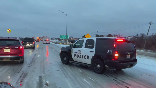

Over 360,000 Texans without power as ice storm continues to move across Texas
Over 360,000 Texans across the Lone Star State are currently without power as the deadly ice storm that's causing problems continues to move across the state.
Over 360,000 Texans across the Lone Star State are currently without power as the deadly ice storm that's causing problems continues to move across the state.


Houston tornado: Red Cross to set up at Beamer Place Apartments to help tenants affected
On Thursday and Friday, the Red Cross will be there from 9 a.m. until 5 p.m. helping people displaced by the recent tornadoes.
On Thursday and Friday, the Red Cross will be there from 9 a.m. until 5 p.m. helping people displaced by the recent tornadoes.

Wednesday evening weather forecast with Meteorologist Remeisha Shade
Isolated light icing is still possible NW of Houston up around Washington county where a Winter Weather Advisory has been extended until 6 AM Thursday. Major issues are not expected, but a few icy spots might develop on bridges, sidewalks, etc. Unseasonably cold air sticks around tonight and tomorrow with 30s tonight and 40s Thursday. Rounds of light to moderate rain will move through tonight through Thursday morning, tapering off during Thursday afternoon. There's a slim shot for some flooding issues to pop up, especially in areas that have picked up several inches of rain recently. Pattern FINALLY starts to shift by Friday with drier air and more sunshine returning. Temps gradually heat up again with the 70s expected by Sunday and Monday.
Isolated light icing is still possible NW of Houston up around Washington county where a Winter Weather Advisory has been extended until 6 AM Thursday. Major issues are not expected, but a few icy spots might develop on bridges, sidewalks, etc. Unseasonably cold air sticks around tonight and tomorrow with 30s tonight and 40s Thursday. Rounds of light to moderate rain will move through tonight through Thursday morning, tapering off during Thursday afternoon. There's a slim shot for some flooding issues to pop up, especially in areas that have picked up several inches of rain recently. Pattern FINALLY starts to shift by Friday with drier air and more sunshine returning. Temps gradually heat up again with the 70s expected by Sunday and Monday.
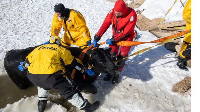

Cow rescued after falling through 7-inch-thick ice in Colorado
Mountain View Fire Rescue said it was an unusual call for help and it took a team effort to pull the animal to safety.
Mountain View Fire Rescue said it was an unusual call for help and it took a team effort to pull the animal to safety.
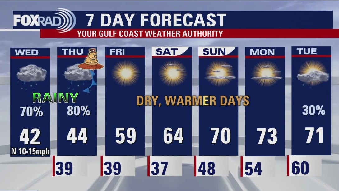
Wednesday afternoon weather forecast with Meteorologist John Dawson
It's going to be a "near miss" for the Houston area for one more day with temperatures, fortunately, remaining above freezing here, but likely stuck near 40 degrees all day. Elsewhere in Texas, travel is at a standstill with dangerous ice covering roads in the north and central Texas. Watch for potential ice from Brenham westward and Huntsville northward. A few sleet pellets could mix in with rain today closer to Houston, but doesn't present a hazard. Expect off-and-on rain today, tonight, and tomorrow with improving conditions Friday through the weekend. In fact, sunshine and highs near 70 will return by Sunday.
It's going to be a "near miss" for the Houston area for one more day with temperatures, fortunately, remaining above freezing here, but likely stuck near 40 degrees all day. Elsewhere in Texas, travel is at a standstill with dangerous ice covering roads in the north and central Texas. Watch for potential ice from Brenham westward and Huntsville northward. A few sleet pellets could mix in with rain today closer to Houston, but doesn't present a hazard. Expect off-and-on rain today, tonight, and tomorrow with improving conditions Friday through the weekend. In fact, sunshine and highs near 70 will return by Sunday.
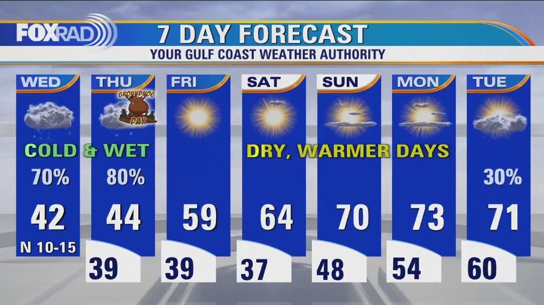
Houston forecast: Cold, misty and rainy at times on Wednesday
It's going to be a "near miss" for the Houston area for one more day with temperatures fortunately remaining above freezing here, but likely stuck near 40 degrees all day. Elsewhere in Texas, travel is at a standstill with dangerous ice covering roads in north and central Texas. Watch for potential ice from Brenham westward and Huntsville northward. A few sleet pellets could mix in with rain today closer to Houston, but doesn't present a hazard. Expect off and on rain today, tonight and tomorrow with improving conditions Friday through the weekend. In fact, sunshine and highs near 70 will return by Sunday.
It's going to be a "near miss" for the Houston area for one more day with temperatures fortunately remaining above freezing here, but likely stuck near 40 degrees all day. Elsewhere in Texas, travel is at a standstill with dangerous ice covering roads in north and central Texas. Watch for potential ice from Brenham westward and Huntsville northward. A few sleet pellets could mix in with rain today closer to Houston, but doesn't present a hazard. Expect off and on rain today, tonight and tomorrow with improving conditions Friday through the weekend. In fact, sunshine and highs near 70 will return by Sunday.
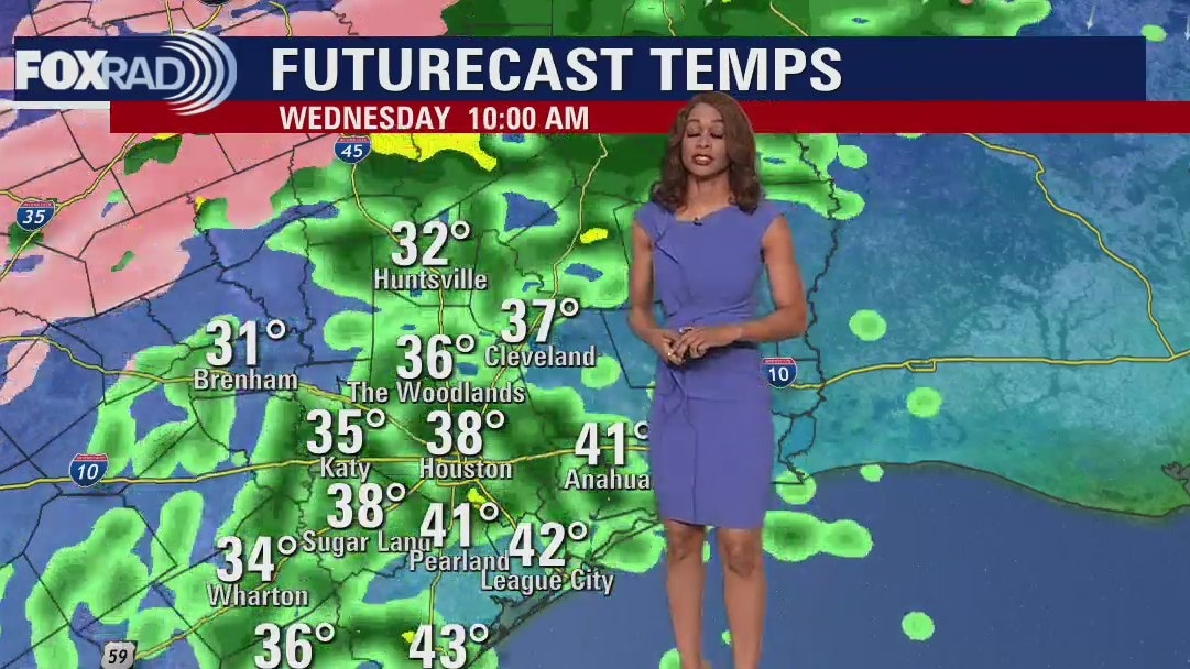
Wednesday morning Houston-area weather forecast
Winter Storm Warning is in effect for Washington county until Noon Wednesday which includes Brenham. Winter Weather Advisory is in place until Noon Wednesday for Walker, Grimes, Waller, Austin & Colorado counties. Expect the chance for a light glaze of ice tonight through Wednesday morning just NW of Houston. Precipitation should be mainly rain for the Houston area. Temperatures will stay chilly the next few days with lows in the 30s and highs in the 40s. Pattern does another major shift heading into the weekend with warmer, brighter & drier weather expected. Enjoy the rest of your week and make sure to download the FOX 26 weather app!
Winter Storm Warning is in effect for Washington county until Noon Wednesday which includes Brenham. Winter Weather Advisory is in place until Noon Wednesday for Walker, Grimes, Waller, Austin & Colorado counties. Expect the chance for a light glaze of ice tonight through Wednesday morning just NW of Houston. Precipitation should be mainly rain for the Houston area. Temperatures will stay chilly the next few days with lows in the 30s and highs in the 40s. Pattern does another major shift heading into the weekend with warmer, brighter & drier weather expected. Enjoy the rest of your week and make sure to download the FOX 26 weather app!


Texas A&M University canceling classes on Wednesday due to winter storm
Texas A&M has announced that they are canceling classes at the Bryan-College Station campus on Wednesday, February 1 due to the winter storm that's moving across North and Central Texas.
Texas A&M has announced that they are canceling classes at the Bryan-College Station campus on Wednesday, February 1 due to the winter storm that's moving across North and Central Texas.

Tuesday evening weather forecast with Meteorologist Remeisha Shade
Winter Storm Warning is in effect for Washington county until Noon Wednesday which includes Brenham. Winter Weather Advisory is in place until Noon Wednesday for Walker, Grimes, Waller, and Austin & Colorado counties. Expect the chance for a light glaze of ice tonight through Wednesday morning just NW of Houston. Precipitation should be mainly rain for the Houston area. Temperatures will stay chilly for the next few days with lows in the 30s and highs in the 40s. The pattern does another major shift heading into the weekend with warmer, brighter & drier weather expected. Enjoy the rest of your week and make sure to download the FOX 26 weather app!
Winter Storm Warning is in effect for Washington county until Noon Wednesday which includes Brenham. Winter Weather Advisory is in place until Noon Wednesday for Walker, Grimes, Waller, and Austin & Colorado counties. Expect the chance for a light glaze of ice tonight through Wednesday morning just NW of Houston. Precipitation should be mainly rain for the Houston area. Temperatures will stay chilly for the next few days with lows in the 30s and highs in the 40s. The pattern does another major shift heading into the weekend with warmer, brighter & drier weather expected. Enjoy the rest of your week and make sure to download the FOX 26 weather app!

Winter storm causes slick roads in Central, North Texas
A winter storm warning is covering much of the central U.S. including parts of Texas. The weather is causing interstate closures and some power outages.
A winter storm warning is covering much of the central U.S. including parts of Texas. The weather is causing interstate closures and some power outages.