


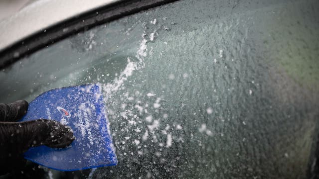
Preparing your vehicle for the winter freeze, what you need to know
As we prepare for that winter freeze, FOX 26’s Gabby Hart shares an important reminder on how to ensure your vehicle is ready for the cold weather.
As we prepare for that winter freeze, FOX 26’s Gabby Hart shares an important reminder on how to ensure your vehicle is ready for the cold weather.

Tuesday evening weather forecast with Meteorologist Remeisha Shade
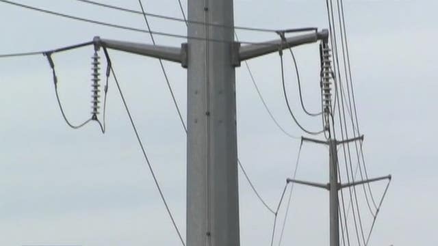
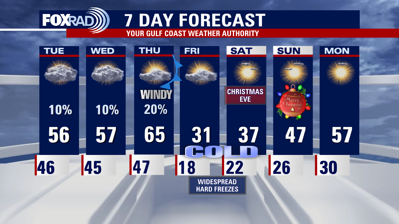
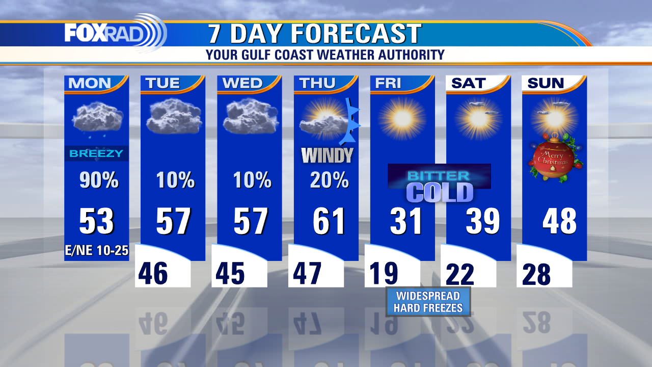
Preparations for our dangerous arctic blast should be completed by Thursday morning! Weather should remain cool and quiet tonight and Wednesday with just a slim chance for a shower. Major arctic blast will arrive by Thursday afternoon sending temperatures down into the teens and 20s by early Friday. Wind gusts of 30-40 mph will also mean dangerous wind chill values near zero late Thursday and early Friday. Hard Freeze Watch is in effect for SE Texas from Noon Thursday - Noon Saturday. Wind Chill Watch is in effect from 6 PM Thursday until Noon Friday. Scattered power outages due to the strong wind will be possible late Thursday into early Friday. At least we are not expecting any snow or ice with this event, just chilly temps. Still make sure your home is winterized with your pets, plants & pipes protected. Also don't forget to wear extra layers while outside during this cold spell. Much warmer temps look to return by the middle of next week!
Preparations for our dangerous arctic blast should be completed by Thursday morning! Weather should remain cool and quiet tonight and Wednesday with just a slim chance for a shower. Major arctic blast will arrive by Thursday afternoon sending temperatures down into the teens and 20s by early Friday. Wind gusts of 30-40 mph will also mean dangerous wind chill values near zero late Thursday and early Friday. Hard Freeze Watch is in effect for SE Texas from Noon Thursday - Noon Saturday. Wind Chill Watch is in effect from 6 PM Thursday until Noon Friday. Scattered power outages due to the strong wind will be possible late Thursday into early Friday. At least we are not expecting any snow or ice with this event, just chilly temps. Still make sure your home is winterized with your pets, plants & pipes protected. Also don't forget to wear extra layers while outside during this cold spell. Much warmer temps look to return by the middle of next week!


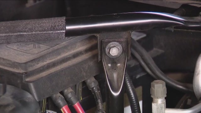
Contractor advises Houstonians turn off water completely and drain pipes, instead of insulating pipes
Many Houstonians say they've learned their lesson from last year’s freeze. This time around, they’re leaving nothing to chance.
Many Houstonians say they've learned their lesson from last year’s freeze. This time around, they’re leaving nothing to chance.
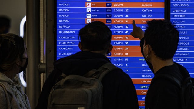

This is the best time to travel for Christmas to avoid winter storm cancellations, delays
A major winter storm is expected to produce damaging winds and drop feet of snow in many locations this week, and with the Christmas holiday travel season in full effect, the timing couldn’t be worse.
A major winter storm is expected to produce damaging winds and drop feet of snow in many locations this week, and with the Christmas holiday travel season in full effect, the timing couldn’t be worse.

Tuesday afternoon weather forecast with Meteorologist Remeisha Shade
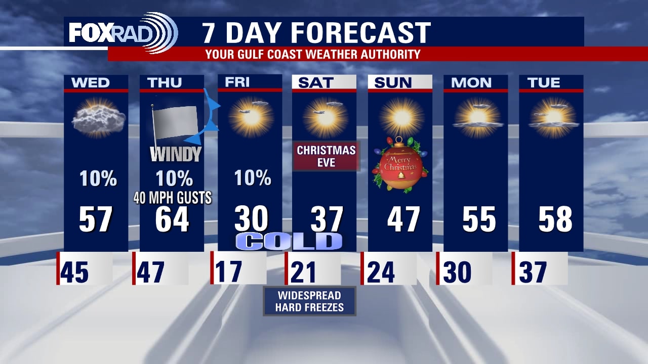
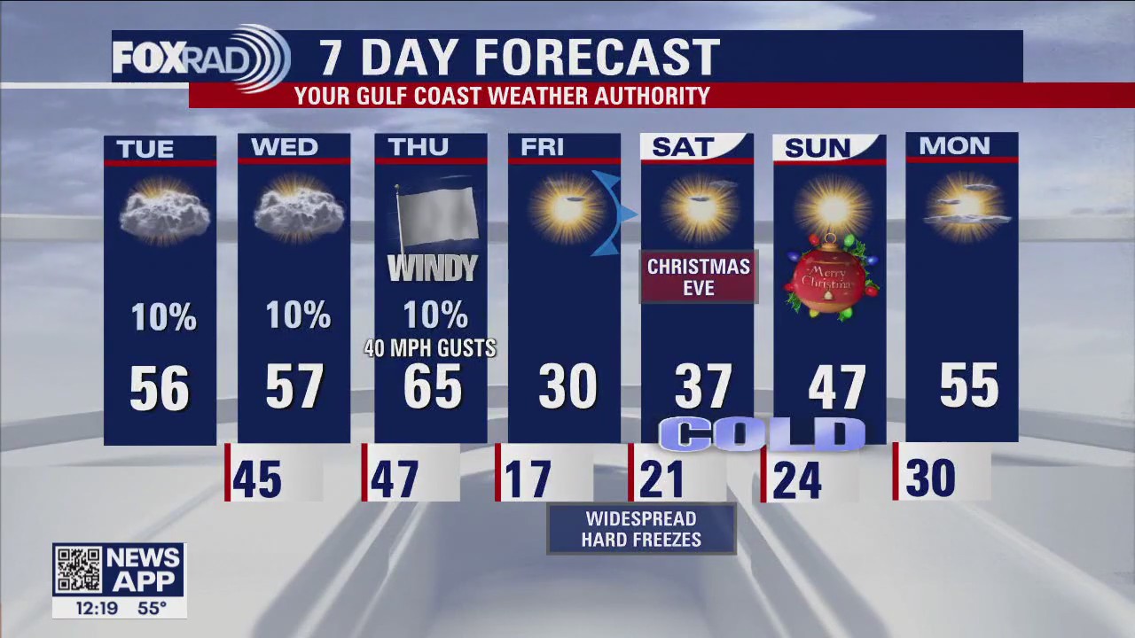
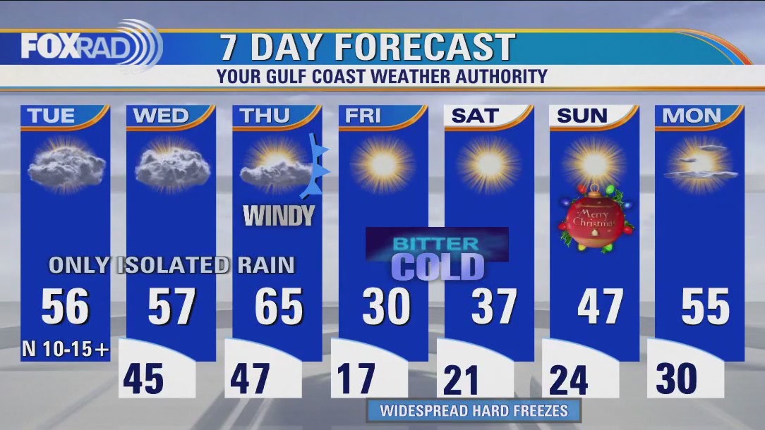
Cloudy, cool & quiet with only isolated rain through Thursday morning so you've got until then to complete Christmas + 4 P preps. Scattered power outages due to gusty winds up around 40mph are also possible beginning Thursday afternoon, so plan for that as well just in case. An extended period of time of up to 48 hours below freezing is possible with single digit if not negative wind chills during the coldest parts of the day. In an ironic twist of "Only in Texas" weather events, after bottoming out in the teens Friday morning... day time highs could reach the low-mid 70s by middle of next week!
Cloudy, cool & quiet with only isolated rain through Thursday morning so you've got until then to complete Christmas + 4 P preps. Scattered power outages due to gusty winds up around 40mph are also possible beginning Thursday afternoon, so plan for that as well just in case. An extended period of time of up to 48 hours below freezing is possible with single digit if not negative wind chills during the coldest parts of the day. In an ironic twist of "Only in Texas" weather events, after bottoming out in the teens Friday morning... day time highs could reach the low-mid 70s by middle of next week!

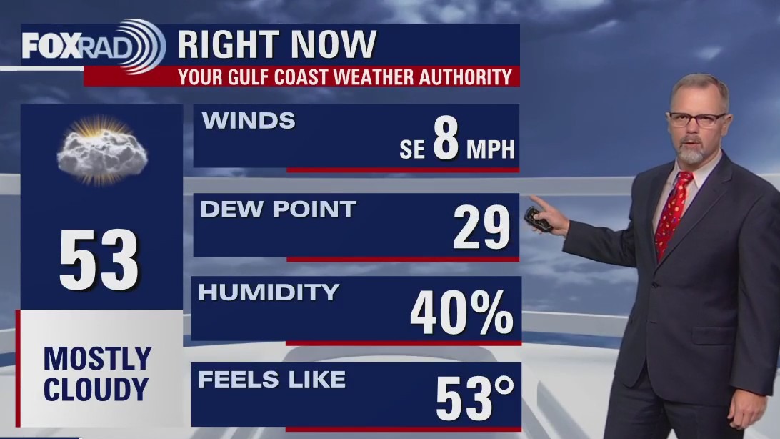
Light drizzle Tuesday morning; cloudy, cool and quiet afternoon
Cloudy, cool & quiet with only isolated rain through Thursday morning so you've got until then to complete Christmas + 4 P preps. Scattered power outages due to gusty winds up around 40 mph are also possible beginning Thursday afternoon, so plan for that as well just in case. An extended period of time of up to 48 hours below freezing is possible with single digit if not negative wind chills during the coldest parts of the day. In an ironic twist of "Only in Texas" weather events, after bottoming out in the teens Friday morning... day time highs could reach the low-mid 70s by middle of next week!
Cloudy, cool & quiet with only isolated rain through Thursday morning so you've got until then to complete Christmas + 4 P preps. Scattered power outages due to gusty winds up around 40 mph are also possible beginning Thursday afternoon, so plan for that as well just in case. An extended period of time of up to 48 hours below freezing is possible with single digit if not negative wind chills during the coldest parts of the day. In an ironic twist of "Only in Texas" weather events, after bottoming out in the teens Friday morning... day time highs could reach the low-mid 70s by middle of next week!

Tuesday morning weather forecast
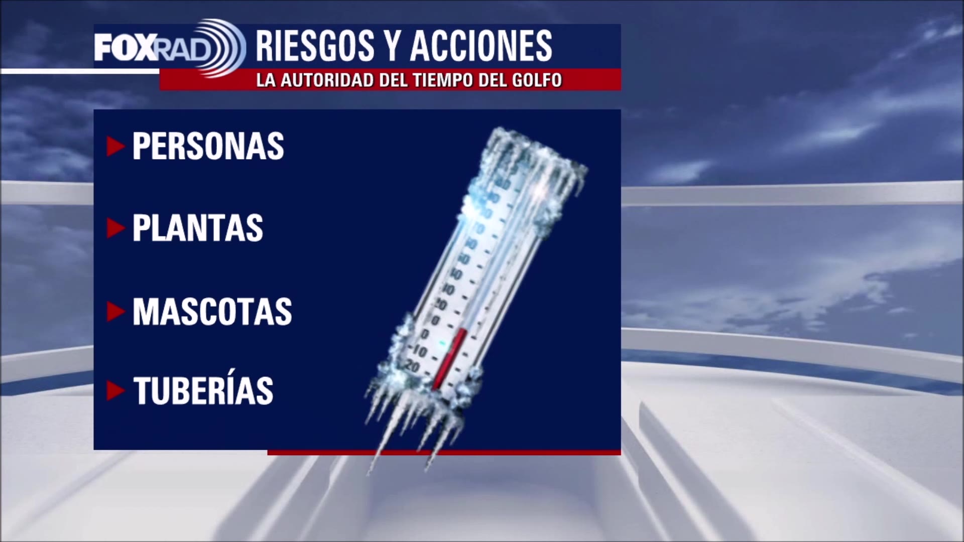
Huge changes are on the way this week leading up to the Christmas holiday this Sunday! You will have two cool but mainly quiet days to prepare for upcoming freezing conditions later this week. Next few days should be mainly dry with only a slim chance of a shower and highs in the 50s. Temps will briefly soar to the 60s on Thursday ahead of a strong arctic cold front that will send temperatures CRASHING by Thursday evening. In fact, we will end up in the teens by Thursday night and likely remain below freezing Friday and early Saturday! Remember to protect yourself with extra layers, cover plants, cover/wrap pipes and make sure your pets are warm also. Christmas day temps will be warmer but still well below normal climbing to the 40s by Sunday afternoon. We finally start to crawl out of the chill early next week with highs near 60 by Monday. Prepare now to stay safe in the cold!
Huge changes are on the way this week leading up to the Christmas holiday this Sunday! You will have two cool but mainly quiet days to prepare for upcoming freezing conditions later this week. Next few days should be mainly dry with only a slim chance of a shower and highs in the 50s. Temps will briefly soar to the 60s on Thursday ahead of a strong arctic cold front that will send temperatures CRASHING by Thursday evening. In fact, we will end up in the teens by Thursday night and likely remain below freezing Friday and early Saturday! Remember to protect yourself with extra layers, cover plants, cover/wrap pipes and make sure your pets are warm also. Christmas day temps will be warmer but still well below normal climbing to the 40s by Sunday afternoon. We finally start to crawl out of the chill early next week with highs near 60 by Monday. Prepare now to stay safe in the cold!

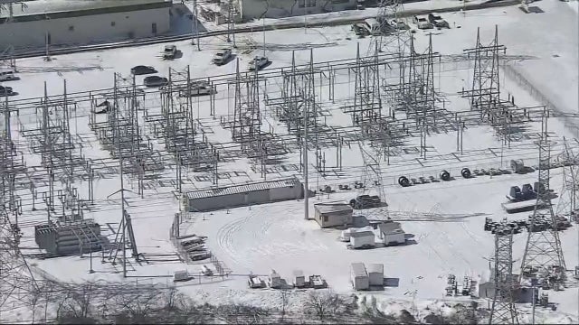
Experts 'confident' in the Texas power grid as many brace for Arctic blast
Officials in the Houston-area are urging people to get ready for unusually cold weather expected for later this week.
Officials in the Houston-area are urging people to get ready for unusually cold weather expected for later this week.
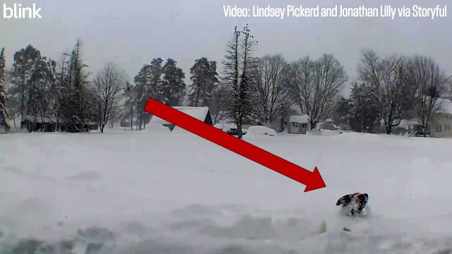

Watch: Saint Bernard engulfed by lake-effect snowfall in New York
As of Monday morning, the National Weather Service had recorded 37 inches of snow in Osceola, which is just east of Lake Ontario.
As of Monday morning, the National Weather Service had recorded 37 inches of snow in Osceola, which is just east of Lake Ontario.

Greater Houston preparing for artic blast, residents having flashbacks of 2021 winter storm
Freezing temperatures are headed to Houston and residents are having flashbacks of the Winter Storm that hit Texas in February 2021.
Freezing temperatures are headed to Houston and residents are having flashbacks of the Winter Storm that hit Texas in February 2021.

Huge changes are on the way this week leading up to the Christmas holiday this Sunday!
You will have two cool but mainly quiet days to prepare for upcoming freezing conditions later this week. The next few days should be mainly dry with only a slim chance of a shower and highs in the 50s. Temps will briefly soar to the 60s on Thursday ahead of a strong arctic cold front that will send temperatures CRASHING by Thursday evening. In fact, we will end up in the teens by Thursday night and likely remain below-freezing Friday and early Saturday! Remember to protect yourself with extra layers, cover plants, cover/wrap pipes and make sure your pets are warm also. Christmas day temps will be warmer but still well below normal climbing to the 40s by Sunday afternoon. We finally start to crawl out of the chill early next week with highs near 60 by Monday. Prepare now to stay safe in the cold!
You will have two cool but mainly quiet days to prepare for upcoming freezing conditions later this week. The next few days should be mainly dry with only a slim chance of a shower and highs in the 50s. Temps will briefly soar to the 60s on Thursday ahead of a strong arctic cold front that will send temperatures CRASHING by Thursday evening. In fact, we will end up in the teens by Thursday night and likely remain below-freezing Friday and early Saturday! Remember to protect yourself with extra layers, cover plants, cover/wrap pipes and make sure your pets are warm also. Christmas day temps will be warmer but still well below normal climbing to the 40s by Sunday afternoon. We finally start to crawl out of the chill early next week with highs near 60 by Monday. Prepare now to stay safe in the cold!

Greater Houston preparing for artic blast, residents having flashbacks of 2021 winter storm
Freezing temperatures are headed to Houston and residents are having flashbacks of the Winter Storm that hit Texas in February 2021.
Freezing temperatures are headed to Houston and residents are having flashbacks of the Winter Storm that hit Texas in February 2021.

Safety tips as Houston prepares for colder than normal temperatures
The temps are expected to drop later this week and into Christmas weekend, and while energy officials say they are prepared, are still encouraging residents to be prepared and stay safe.
The temps are expected to drop later this week and into Christmas weekend, and while energy officials say they are prepared, are still encouraging residents to be prepared and stay safe.

El Tiempo FOX 26 con Lena Maria 18 de diciembre de 2022
#FOX26 Meteor?loga Lena Maria Arango tiene su pron?stico para la semana laboral.
#FOX26 Meteor?loga Lena Maria Arango tiene su pron?stico para la semana laboral.


Bundle up! NASA finds the coldest spot on Earth
NASA officials say they’ve pinpointed the perfect spot for the perfect winter getaway.
NASA officials say they’ve pinpointed the perfect spot for the perfect winter getaway.

Rainy, chilly Monday
Not the best start to the week as a coastal low brings rainy, chilly, breezy conditions. But, today will feel like paradise compared to the end of the week. Tuesday and Wednesday will be cloudy, cool but mostly dry for Christmas and 4 P's prep. Thursday will be a bit of a wild ride, as depending on the timing of the front the coast could near 70 while inland locations get stuck in the 50s. Gusty winds will rapidly drive down temps wind chills and could cause isolated power outages. As a Christmas present, we should finally get above 40 by Sunday.
Not the best start to the week as a coastal low brings rainy, chilly, breezy conditions. But, today will feel like paradise compared to the end of the week. Tuesday and Wednesday will be cloudy, cool but mostly dry for Christmas and 4 P's prep. Thursday will be a bit of a wild ride, as depending on the timing of the front the coast could near 70 while inland locations get stuck in the 50s. Gusty winds will rapidly drive down temps wind chills and could cause isolated power outages. As a Christmas present, we should finally get above 40 by Sunday.

Mostly cloudy, dry Sunday evening in the 50s
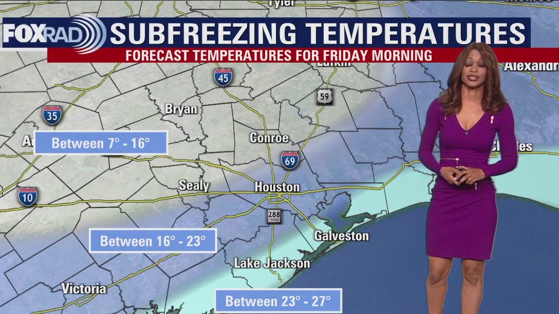
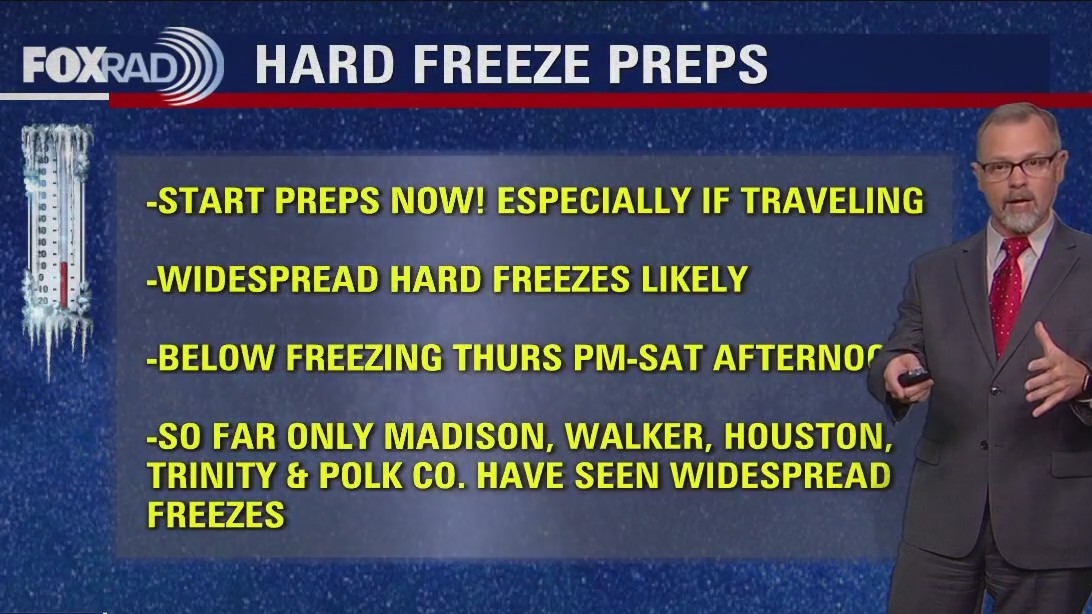
This week's forecast is still on track to start off wet and end cold, VERY COLD. Showers start spreading from the coast towards downtown Houston early Monday and continue for most of the day. The middle of the week looks cool and dry with the strong Arctic Front arriving Thursday afternoon. A widespread Hard Freeze (temperatures below 25 degrees) hits southeast Texas Friday morning and possibly Saturday morning. Christmas Day could start below freezing but will warm up to the mid-40s in the afternoon.
This week's forecast is still on track to start off wet and end cold, VERY COLD. Showers start spreading from the coast towards downtown Houston early Monday and continue for most of the day. The middle of the week looks cool and dry with the strong Arctic Front arriving Thursday afternoon. A widespread Hard Freeze (temperatures below 25 degrees) hits southeast Texas Friday morning and possibly Saturday morning. Christmas Day could start below freezing but will warm up to the mid-40s in the afternoon.
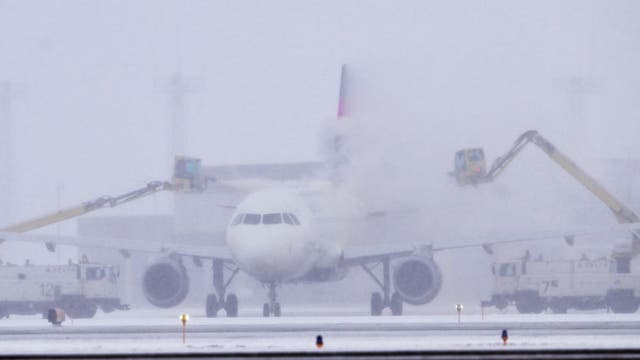

'High impact' Christmas week winter storm could lead to travel nightmare for millions of Americans
Those living or traveling to and from the eastern third of the country will need to pay very close attention to the forecast as it becomes locked in in the coming days.
Those living or traveling to and from the eastern third of the country will need to pay very close attention to the forecast as it becomes locked in in the coming days.

Partly cloudy, chilly Saturday evening in the 50s
The rest of the weekend looks cold but overall pleasant for southeast Texas. A coastal low will bring showers and isolated heavy downpours for Houston and surrounding areas on Monday. The arctic cold front is still on track to bring widespread, prolonged freezing temperatures starting on Thursday night. Now is a good time to start preparing for these cold days and nights.
The rest of the weekend looks cold but overall pleasant for southeast Texas. A coastal low will bring showers and isolated heavy downpours for Houston and surrounding areas on Monday. The arctic cold front is still on track to bring widespread, prolonged freezing temperatures starting on Thursday night. Now is a good time to start preparing for these cold days and nights.


Inside the New Orleans tornado: Dashcam video shows moments car is overtaken by storm
Richard Rivera said his car was parked, but his dashcam ran the entire time as the EF-2 tornado moved through his New Orleans-area neighborhood.
Richard Rivera said his car was parked, but his dashcam ran the entire time as the EF-2 tornado moved through his New Orleans-area neighborhood.