


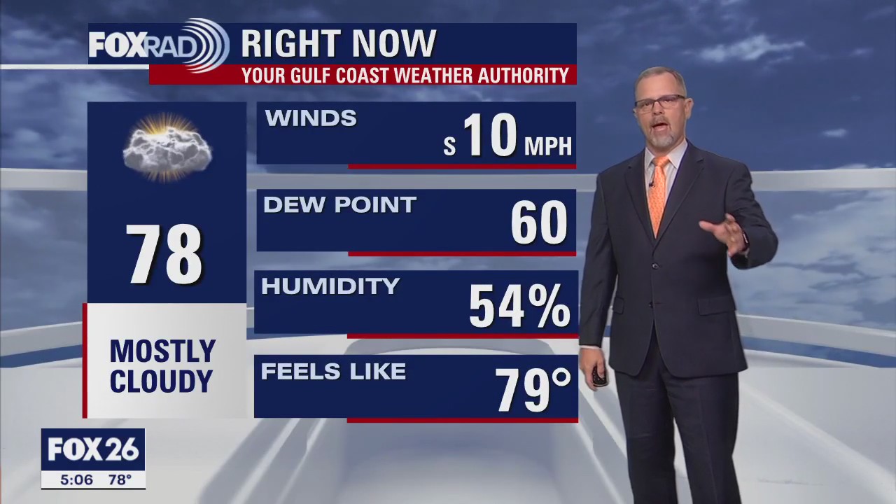
Wednesday afternoon weather forecast with Meteorologist John Dawson
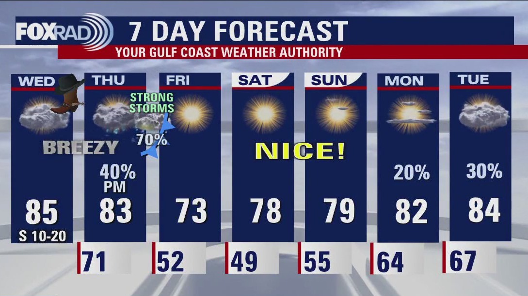
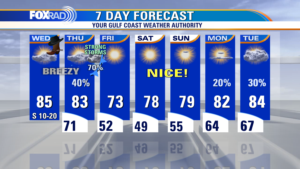
Today will be another unseasonably warm, possibly record-setting afternoon with only a slight chance for light showers. Our main forecast concern is a cold front that will move our way Thursday night. Isolated severe storms are possible with a much higher chance for high winds and tornadoes in northeast Texas, north Louisiana, and parts of Arkansas. The great news is that Friday, Saturday, and Sunday are looking great with clear skies, less heat, and much lower humidity.
Today will be another unseasonably warm, possibly record-setting afternoon with only a slight chance for light showers. Our main forecast concern is a cold front that will move our way Thursday night. Isolated severe storms are possible with a much higher chance for high winds and tornadoes in northeast Texas, north Louisiana, and parts of Arkansas. The great news is that Friday, Saturday, and Sunday are looking great with clear skies, less heat, and much lower humidity.

Wednesday morning weather with Chie Meteorologist Mike Iscovitz
Today will be another unseasonably warm, possibly record-setting afternoon with only a slight chance for light showers. Our main forecast concern is a cold front that will move our way Thursday night. Isolated severe storms are possible with a much higher chance for high winds and tornadoes in northeast Texas, north Louisiana, and parts of Arkansas. The great news is that Friday, Saturday, and Sunday are looking great with clear skies, less heat, and much lower humidity.
Today will be another unseasonably warm, possibly record-setting afternoon with only a slight chance for light showers. Our main forecast concern is a cold front that will move our way Thursday night. Isolated severe storms are possible with a much higher chance for high winds and tornadoes in northeast Texas, north Louisiana, and parts of Arkansas. The great news is that Friday, Saturday, and Sunday are looking great with clear skies, less heat, and much lower humidity.

Wednesday morning Houston-weather forecast
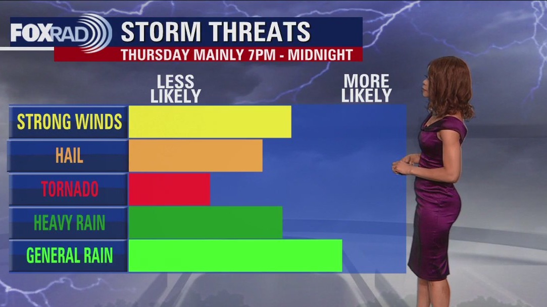
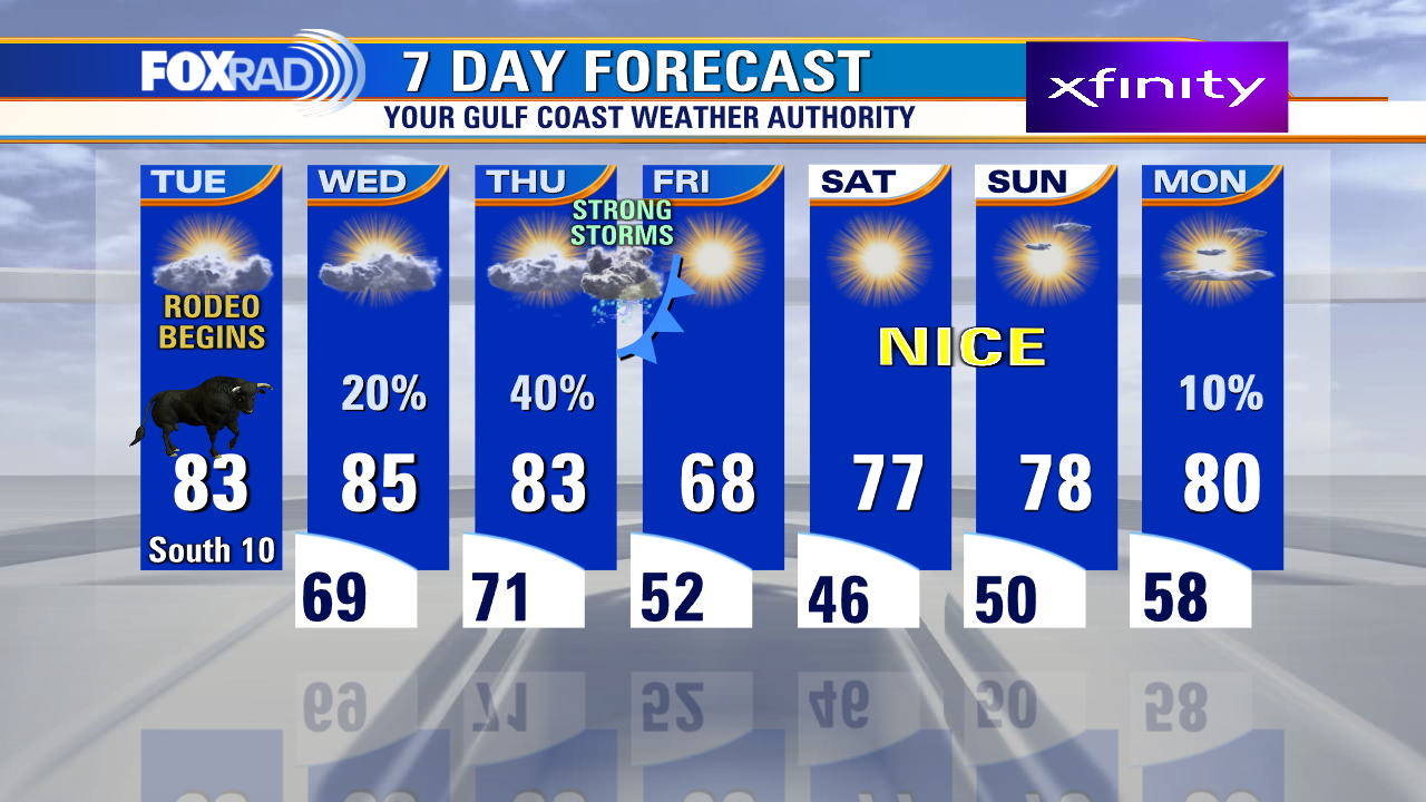
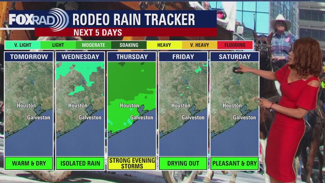
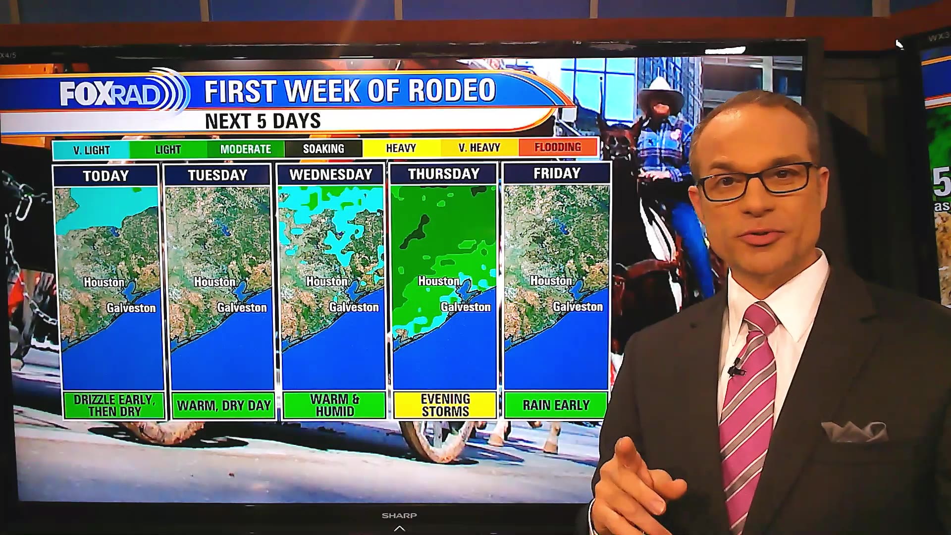
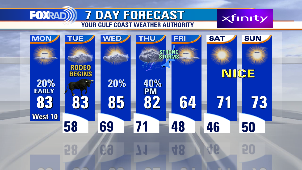
Look for more near record heat Wednesday and Thursday before changes arrive. Rodeo the next few nights will be mild and muggy with temps dropping to near 70. The next big storm system rolls in Thursday evening bringing a decent chance for storms. Some of those storms could be severe with isolated tornadoes, damaging winds, heavy rain, and hail all being threats. Main timing is from 6 p.m. until midnight Thursday night. Make sure to have the FOX 26 weather app downloaded to keep track of the severe threat. Behind the front, Friday looks much cooler with highs only in the 60s and lows in the 40s. First March rodeo weekend this year looks pleasant and dry.
Look for more near record heat Wednesday and Thursday before changes arrive. Rodeo the next few nights will be mild and muggy with temps dropping to near 70. The next big storm system rolls in Thursday evening bringing a decent chance for storms. Some of those storms could be severe with isolated tornadoes, damaging winds, heavy rain, and hail all being threats. Main timing is from 6 p.m. until midnight Thursday night. Make sure to have the FOX 26 weather app downloaded to keep track of the severe threat. Behind the front, Friday looks much cooler with highs only in the 60s and lows in the 40s. First March rodeo weekend this year looks pleasant and dry.

Tuesday evening weather forecast
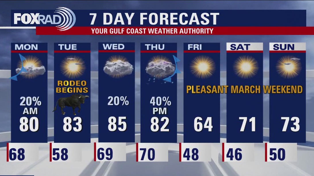
Howdy! It's time to rodeo everyone! It's opening day for the 2023 Houston Livestock Show & Rodeo and it's a warm and humid start with temps in the 80s this afternoon! Look for more near record heat Wednesday and Thursday before changes arrive. Rodeo the next few nights will be mild and muggy with temps dropping to near 70. Next big storm system rolls in Thursday evening bringing a decent chance for storms. Some of those storms could be severe with isolated tornadoes, damaging winds, heavy rain, and hail all being threats. Main timing is from 6pm until midnight Thursday night. Make sure to have the FOX 26 weather app downloaded to keep track of the severe threat. Behind the front, Friday looks much cooler with highs only in the 60s and lows in the 40s. First March rodeo weekend this year looks pleasant and dry.
Howdy! It's time to rodeo everyone! It's opening day for the 2023 Houston Livestock Show & Rodeo and it's a warm and humid start with temps in the 80s this afternoon! Look for more near record heat Wednesday and Thursday before changes arrive. Rodeo the next few nights will be mild and muggy with temps dropping to near 70. Next big storm system rolls in Thursday evening bringing a decent chance for storms. Some of those storms could be severe with isolated tornadoes, damaging winds, heavy rain, and hail all being threats. Main timing is from 6pm until midnight Thursday night. Make sure to have the FOX 26 weather app downloaded to keep track of the severe threat. Behind the front, Friday looks much cooler with highs only in the 60s and lows in the 40s. First March rodeo weekend this year looks pleasant and dry.

Deputy finds elderly dog nearly frozen to death, returns pet to owner
Authorities in Maine said the 14-year-old dog had tried to climb out of ditch but stopped when her paw got too cold.
Authorities in Maine said the 14-year-old dog had tried to climb out of ditch but stopped when her paw got too cold.
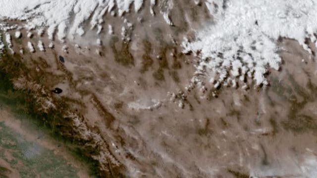

Haboobs roared through Texas Sunday; but what are they?
A powerful dust storm called a Haboob roared through West Texas and the Panhandle late on Sunday and pushed dusty, hazing conditions all the way into the Houston area.
A powerful dust storm called a Haboob roared through West Texas and the Panhandle late on Sunday and pushed dusty, hazing conditions all the way into the Houston area.

Tuesday morning weather forecast with Chief Meteorologist Mike Iscovitz
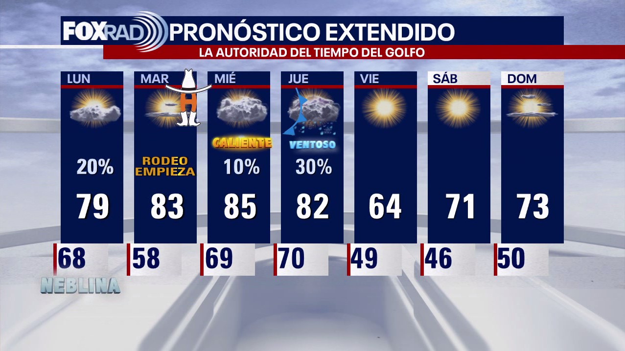
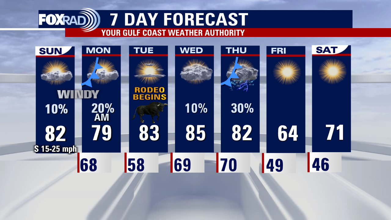
The first week of the Houston Rodeo will begin with unseasonably warm weather Tuesday through Thursday, then a strong front followed by cooler, much drier air Friday and this weekend. There is some concern for severe storms overnight Thursday into very early Friday, so stay alert for more information as we get closer.
The first week of the Houston Rodeo will begin with unseasonably warm weather Tuesday through Thursday, then a strong front followed by cooler, much drier air Friday and this weekend. There is some concern for severe storms overnight Thursday into very early Friday, so stay alert for more information as we get closer.

Tuesday morning Houston-area weather forecast
We are less than 24 hours away from the official kickoff of the 2023 Houston Livestock Show and Rodeo! Cold front that moved through today brought in drier air but not really cooler air. So that means a warm but dry Day 1 of the rodeo Tuesday with temperatures climbing to the low 80s. Heat hangs on Wednesday with more near record warmth in place. Thursday remains warm but a strong storm system will bring a chance for strong to severe storms by evening. Damaging winds, hail and an isolated tornado will be the main threats so stay alert! Behind that front, it will become more seasonable with high temps in the 60s/70s and chilly nights in the 40s to near 50. The first weekend of rodeo is looking fantastic with pleasant temperatures and abundant sunshine!
We are less than 24 hours away from the official kickoff of the 2023 Houston Livestock Show and Rodeo! Cold front that moved through today brought in drier air but not really cooler air. So that means a warm but dry Day 1 of the rodeo Tuesday with temperatures climbing to the low 80s. Heat hangs on Wednesday with more near record warmth in place. Thursday remains warm but a strong storm system will bring a chance for strong to severe storms by evening. Damaging winds, hail and an isolated tornado will be the main threats so stay alert! Behind that front, it will become more seasonable with high temps in the 60s/70s and chilly nights in the 40s to near 50. The first weekend of rodeo is looking fantastic with pleasant temperatures and abundant sunshine!
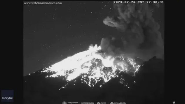

Video shows violent eruption of Mexico's Popocatepetl volcano
Video recorded in San Nicolas de los Ranchos, Mexico, showed the exact moment the volcano exploded just after 10:30 p.m. on Friday.
Video recorded in San Nicolas de los Ranchos, Mexico, showed the exact moment the volcano exploded just after 10:30 p.m. on Friday.
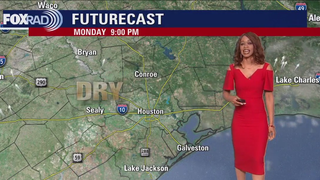

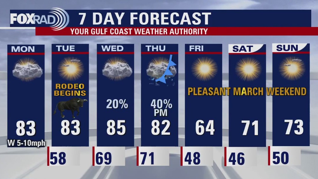
Monday evening Houston-area weather forecast
We are less than 24 hours away from the official kickoff of the 2023 Houston Livestock Show and Rodeo! Cold front that moved through today brought in drier air but not really cooler air. So that means a warm but dry Day 1 of the rodeo Tuesday with temperatures climbing to the low 80s. Heat hangs on Wednesday with more near record warmth in place. Thursday remains warm but a strong storm system will bring a chance for strong to severe storms by evening. Damaging winds, hail and an isolated tornado will be the main threats so stay alert! Behind that front, it will become more seasonable with high temps in the 60s/70s and chilly nights in the 40s to near 50. The first weekend of rodeo is looking fantastic with pleasant temperatures and abundant sunshine!
We are less than 24 hours away from the official kickoff of the 2023 Houston Livestock Show and Rodeo! Cold front that moved through today brought in drier air but not really cooler air. So that means a warm but dry Day 1 of the rodeo Tuesday with temperatures climbing to the low 80s. Heat hangs on Wednesday with more near record warmth in place. Thursday remains warm but a strong storm system will bring a chance for strong to severe storms by evening. Damaging winds, hail and an isolated tornado will be the main threats so stay alert! Behind that front, it will become more seasonable with high temps in the 60s/70s and chilly nights in the 40s to near 50. The first weekend of rodeo is looking fantastic with pleasant temperatures and abundant sunshine!

Monday afternoon weather forecast with Meteorologist John Dawson
Warm afternoons will continue through Thursday followed by a round of thunderstorms late. Following that late-week front, we'll feel a brief chill with dry air and a really great weekend.
Warm afternoons will continue through Thursday followed by a round of thunderstorms late. Following that late-week front, we'll feel a brief chill with dry air and a really great weekend.

FOX 26 Houston Rodeo weather forecast with Chief Meteorologist Mike Iscovitz
More warm weather is on the way for the start of Rodeo Houston, but a late-week cold front could bring a round of storms followed by a brief chill.
More warm weather is on the way for the start of Rodeo Houston, but a late-week cold front could bring a round of storms followed by a brief chill.

New report assesses property risk for millions due to destructive winds from hurricanes over next 30 years
An extensive risk of property damage from future tropical storms and hurricanes is predicted along the Southeast and Gulf coasts.
An extensive risk of property damage from future tropical storms and hurricanes is predicted along the Southeast and Gulf coasts.

Monday morning weather forecast with Chief Meteorologist Mike Iscovitz
We have some interesting weather ahead for the first week of the Rodeo. Today will be mostly sunny, warm & very dry following a few morning drizzles. Warm afternoons will continue through Thursday followed by a round of thunderstorms late. Following that late-week front, we'll feel a brief chill with dry air and a really great weekend.
We have some interesting weather ahead for the first week of the Rodeo. Today will be mostly sunny, warm & very dry following a few morning drizzles. Warm afternoons will continue through Thursday followed by a round of thunderstorms late. Following that late-week front, we'll feel a brief chill with dry air and a really great weekend.

Sunday evening/Monday morning weather forecast
A cold front early on Monday will bring a few showers to southeast Texas. This weak front will not bring dramatically cooler air but you will feel the drier west winds. A second, stronger cold front late on Thursday puts rain back in the forecast with another round of cooler and drier air for the weekend. Looks like a quiet/warm start to the Houston Rodeo. The Thursday night Lauren Daigle concert may have some storms to dodge around Houston but the rest of the week looks great!
A cold front early on Monday will bring a few showers to southeast Texas. This weak front will not bring dramatically cooler air but you will feel the drier west winds. A second, stronger cold front late on Thursday puts rain back in the forecast with another round of cooler and drier air for the weekend. Looks like a quiet/warm start to the Houston Rodeo. The Thursday night Lauren Daigle concert may have some storms to dodge around Houston but the rest of the week looks great!


Storms continue to impact states coast-to-coast
Parts of Michigan are still without power after last week's ice storm and meanwhile, California got a break from the recent heavy snow and rain, but they're not done with the winter storm quite yet. FOX's Kevin Uretsky has more on the coast-to-coast storms impacting the nation.
Parts of Michigan are still without power after last week's ice storm and meanwhile, California got a break from the recent heavy snow and rain, but they're not done with the winter storm quite yet. FOX's Kevin Uretsky has more on the coast-to-coast storms impacting the nation.

Mostly cloudy, warm Sunday evening in the 70s
A cold front early on Monday will bring a few showers to southeast Texas. This weak front will not bring dramatically cooler air but you will feel the drier west winds. A second, stronger cold front late on Thursday puts rain back in the forecast with another round of cooler and drier air for the weekend. Looks like a quiet/warm start to the Houston Rodeo. The Thursday night Lauren Daigle concert may have some storms to dodge around Houston but the rest of the week looks great!
A cold front early on Monday will bring a few showers to southeast Texas. This weak front will not bring dramatically cooler air but you will feel the drier west winds. A second, stronger cold front late on Thursday puts rain back in the forecast with another round of cooler and drier air for the weekend. Looks like a quiet/warm start to the Houston Rodeo. The Thursday night Lauren Daigle concert may have some storms to dodge around Houston but the rest of the week looks great!
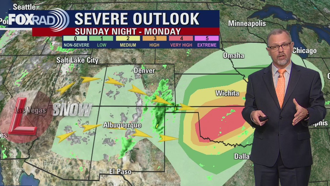

West Coast storm system impacts Midwest
That storm system that brought California snow is taking aim on Oklahoma and the central plains. Severe storms are expected Sunday night and early Monday.
That storm system that brought California snow is taking aim on Oklahoma and the central plains. Severe storms are expected Sunday night and early Monday.

El Tiempo de 26 febrero de 2023
#FOX26 Meteor?loga Lena Maria Arango tiene su pron?stico para la semana laboral.
#FOX26 Meteor?loga Lena Maria Arango tiene su pron?stico para la semana laboral.

Sunday weather forecast with Meteorologist Lena Maria Arango
The same system that brought California snow is set to bring potentially significant severe weather to the central plains overnight. We'll be on the outer edges, receiving only a few early morning light-moderate showers paired with gusty winds. Slightly less humid air will settle in briefly, but we'll still be very warm midweek. Our second front Thursday brings in higher rain chances, and a cool down heading into the weekend.
The same system that brought California snow is set to bring potentially significant severe weather to the central plains overnight. We'll be on the outer edges, receiving only a few early morning light-moderate showers paired with gusty winds. Slightly less humid air will settle in briefly, but we'll still be very warm midweek. Our second front Thursday brings in higher rain chances, and a cool down heading into the weekend.