


Houston weather: Storms likely Wednesday evening, early Thursday morning
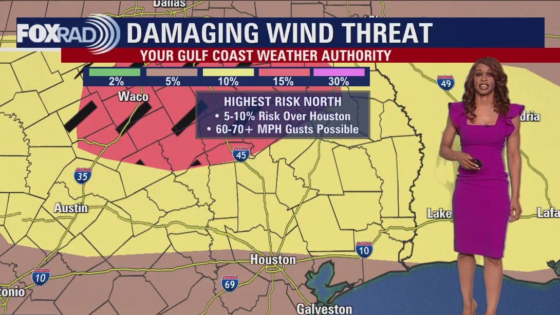
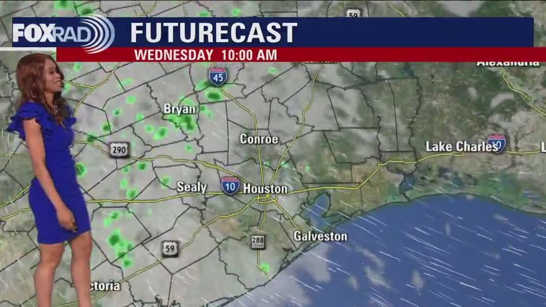
Threat for severe weather will increase late tonight and stick around through early Thursday morning for much of SE Texas. Main window for strong to severe storms will be from 10PM tonight until 7AM Thursday. Strong to severe storms are expected to build in around 10-11 PM tonight from the north rolling into Huntsville & Livingston. Then by Midnight - 1 AM, rain and storms should drop into the Houston area. Models are showing more showers and storms around 4-6 AM and another possible round by 8-9 AM just ahead of the cold front. Severe risk tonight is highest in our northern counties at 2/5 with a 1/5 threat in the southern areas. Large hail, 60-70 MPH winds and heavy downpours will be the main threats. However, there is a 2-5% tornado threat as well so stay alert! We should dry out behind the front Thursday afternoon and evening. Friday looks bright and lovely but Saturday is trending wetter. Look for a decent shot for rain for a big chunk of Saturday, winding down early Sunday. Make sure to keep track of all the changing weather by downloading the FOX 26 Weather App on your phone!
Threat for severe weather will increase late tonight and stick around through early Thursday morning for much of SE Texas. Main window for strong to severe storms will be from 10PM tonight until 7AM Thursday. Strong to severe storms are expected to build in around 10-11 PM tonight from the north rolling into Huntsville & Livingston. Then by Midnight - 1 AM, rain and storms should drop into the Houston area. Models are showing more showers and storms around 4-6 AM and another possible round by 8-9 AM just ahead of the cold front. Severe risk tonight is highest in our northern counties at 2/5 with a 1/5 threat in the southern areas. Large hail, 60-70 MPH winds and heavy downpours will be the main threats. However, there is a 2-5% tornado threat as well so stay alert! We should dry out behind the front Thursday afternoon and evening. Friday looks bright and lovely but Saturday is trending wetter. Look for a decent shot for rain for a big chunk of Saturday, winding down early Sunday. Make sure to keep track of all the changing weather by downloading the FOX 26 Weather App on your phone!

Wednesday afternoon weather forecast with Meteorologist Lena Maria Arango
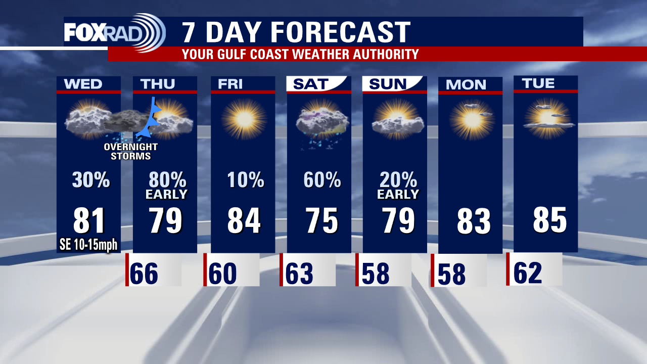
Today will be warm and humid, and after a round of overnight storms conditions will gradually clear on Thursday. Friday looks mostly fantastic and then the exact arrival of the return of rain and storms is a bit fuzzy, but possible from late Friday through early Sunday. Saturday is a challenging forecast, so check back for updates but soggy weather may put a damper on your outdoor plans. For now, it looks like we clear out by Sunday afternoon and have a couple of days of great weather at the start of next week.
Today will be warm and humid, and after a round of overnight storms conditions will gradually clear on Thursday. Friday looks mostly fantastic and then the exact arrival of the return of rain and storms is a bit fuzzy, but possible from late Friday through early Sunday. Saturday is a challenging forecast, so check back for updates but soggy weather may put a damper on your outdoor plans. For now, it looks like we clear out by Sunday afternoon and have a couple of days of great weather at the start of next week.

Wednesday morning weather forecast with Chief Meteorologist Mike Iscovitz
Today will be a warmer, breezy day with a few scattered showers, but watch for active weather overnight. A line of showers and storms is likely between about 11 p.m. tonight and 7 a.m. Thursday morning. A few storms could be strong and 2" downpours are possible. The weather will improve by Thursday afternoon and Friday looks very nice. Rain is now looking more likely for Saturday.
Today will be a warmer, breezy day with a few scattered showers, but watch for active weather overnight. A line of showers and storms is likely between about 11 p.m. tonight and 7 a.m. Thursday morning. A few storms could be strong and 2" downpours are possible. The weather will improve by Thursday afternoon and Friday looks very nice. Rain is now looking more likely for Saturday.

Houston weather - Wet Wednesday possible, be sure to stay weather aware
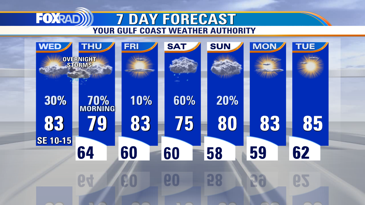
Another line of storms is expected Wednesday night with more storms possible Thursday morning with a cold front. Severe threat Wednesday night into Thursday is highest north of Houston with Houston again in a Category 1/5 threat. So stay alert and make sure you have a way to get warnings! FOX 26 Weather App on your phone is a great way to do that! Isolated showers and storms are possible with another front late Friday into early Saturday. Then we clear out for the rest of the weekend.
Another line of storms is expected Wednesday night with more storms possible Thursday morning with a cold front. Severe threat Wednesday night into Thursday is highest north of Houston with Houston again in a Category 1/5 threat. So stay alert and make sure you have a way to get warnings! FOX 26 Weather App on your phone is a great way to do that! Isolated showers and storms are possible with another front late Friday into early Saturday. Then we clear out for the rest of the weekend.

Houston weather: Stormy night possible in the Houston area
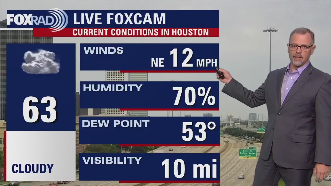
Stay alert for the potential for severe weather this evening and tonight, mainly between 7PM and Midnight. A few storms are expected to build in from the west and could produce some large hail and a few strong wind gusts along with heavy rain. We get a break for much of Wednesday before another line of storms is expected Wednesday night with more storms possible Thursday morning with a cold front. Severe risk for Houston tonight is a Category 1/5 but 2/5 threat is in place just west of Houston. Severe threat Wednesday night into Thursday is highest north of Houston with Houston again in a Category 1/5 threat. So stay alert and make sure you have a way to get warnings! FOX 26 Weather App on your phone is a great way to do that! Isolated showers and storms are possible with another front late Friday into early Saturday. Then we clear out for the rest of the weekend.
Stay alert for the potential for severe weather this evening and tonight, mainly between 7PM and Midnight. A few storms are expected to build in from the west and could produce some large hail and a few strong wind gusts along with heavy rain. We get a break for much of Wednesday before another line of storms is expected Wednesday night with more storms possible Thursday morning with a cold front. Severe risk for Houston tonight is a Category 1/5 but 2/5 threat is in place just west of Houston. Severe threat Wednesday night into Thursday is highest north of Houston with Houston again in a Category 1/5 threat. So stay alert and make sure you have a way to get warnings! FOX 26 Weather App on your phone is a great way to do that! Isolated showers and storms are possible with another front late Friday into early Saturday. Then we clear out for the rest of the weekend.

Tuesday afternoon weather forecast with Meteorologist John Dawson
The next few days present some forecast challenges with a lack of agreement among computer models, but in general, expect some scattered storms today and tomorrow. A few afternoon storms are possible, especially west of Houston this afternoon with a chance for some stronger storms tonight. A line of storms is possible Thursday followed by a sunny Friday.
The next few days present some forecast challenges with a lack of agreement among computer models, but in general, expect some scattered storms today and tomorrow. A few afternoon storms are possible, especially west of Houston this afternoon with a chance for some stronger storms tonight. A line of storms is possible Thursday followed by a sunny Friday.


2023 Hurricane Awareness Tour: Free, public event coming to Houston
The free event aims to raise awareness of tropical cyclone impacts and the danger of getting caught without a preparedness plan, which is why this year's tour will kick off in Houston just in time for Hurricane Season.
The free event aims to raise awareness of tropical cyclone impacts and the danger of getting caught without a preparedness plan, which is why this year's tour will kick off in Houston just in time for Hurricane Season.

Tuesday morning weather forecast with Chief Meteorologist Mike Iscovitz
The next few days present some forecast challenges with a lack of agreement among computer models, but in general, expect some scattered storms today and tomorrow. A few afternoon storms are possible, especially west of Houston this afternoon with a chance for some stronger storms tonight. A line of storms is possible Thursday followed by a sunny Friday.
The next few days present some forecast challenges with a lack of agreement among computer models, but in general, expect some scattered storms today and tomorrow. A few afternoon storms are possible, especially west of Houston this afternoon with a chance for some stronger storms tonight. A line of storms is possible Thursday followed by a sunny Friday.

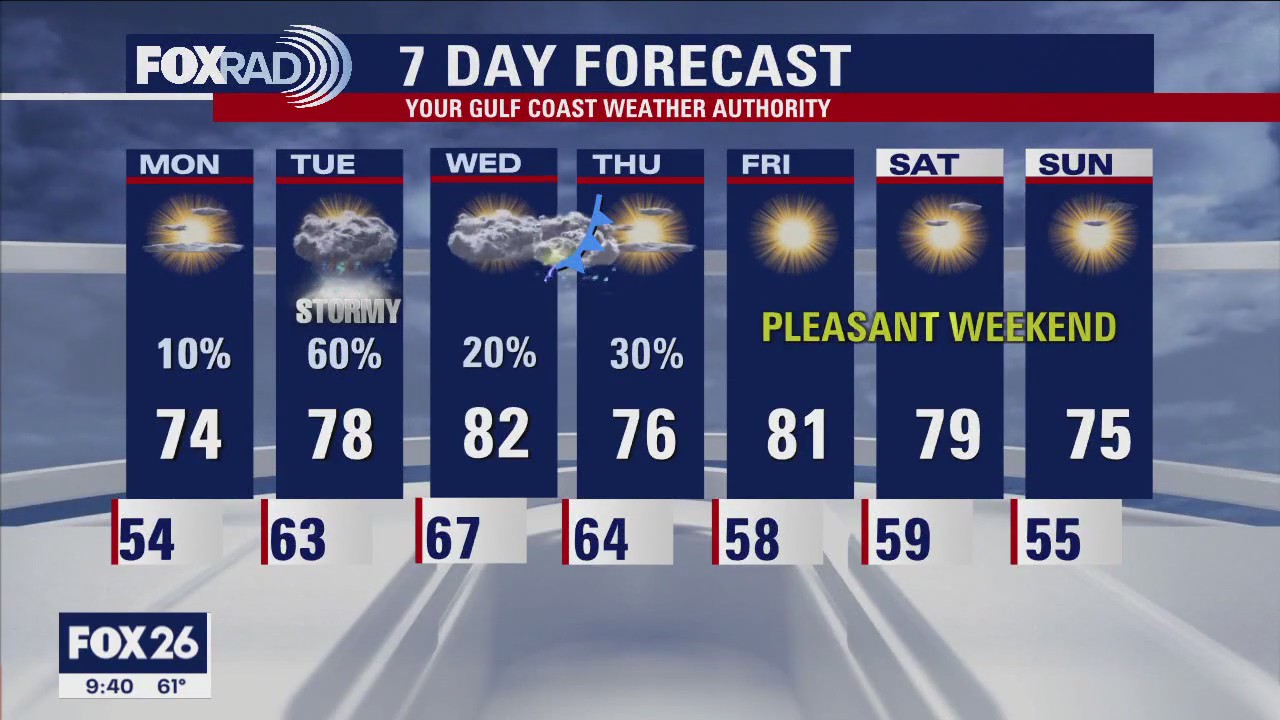
Houston-area weather: Stormy week ahead
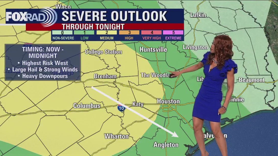
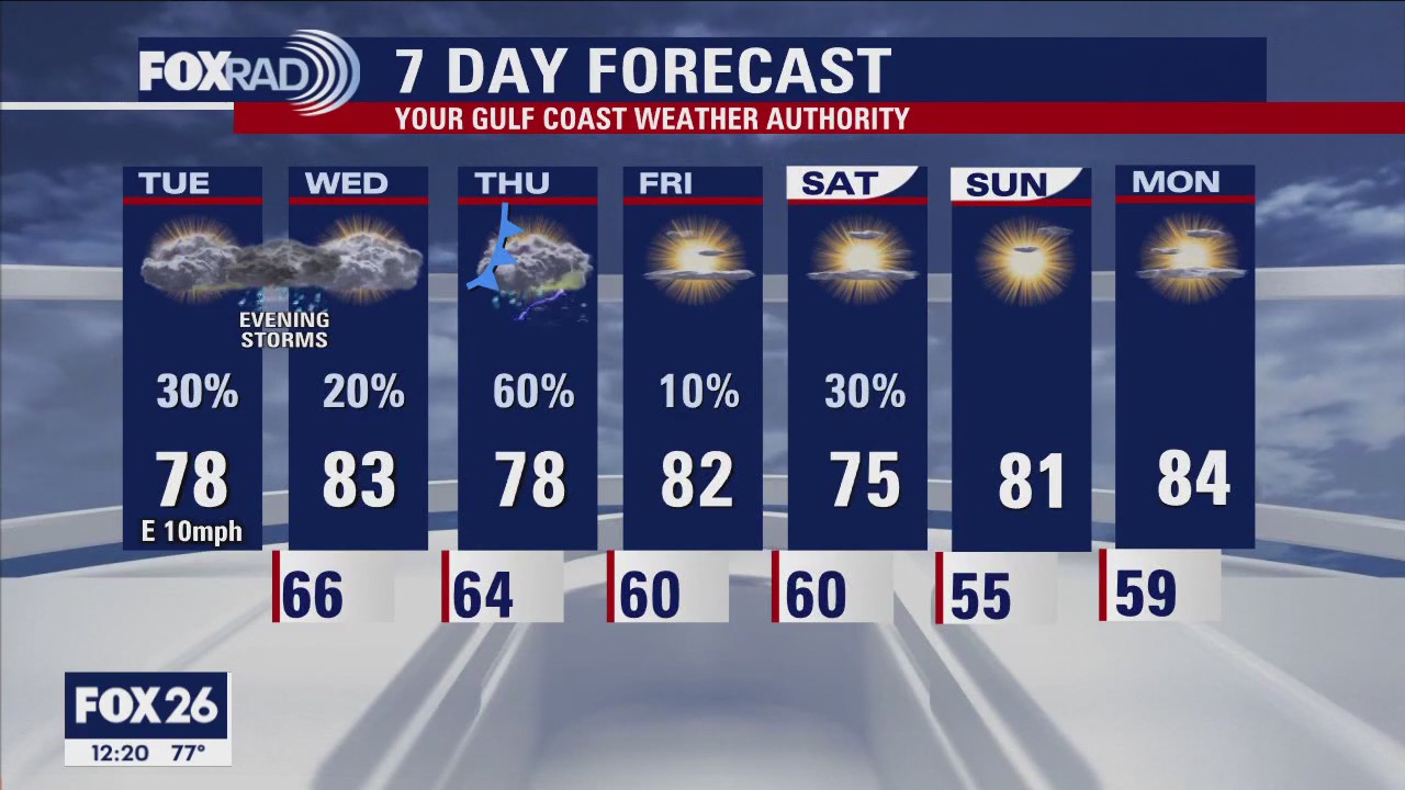
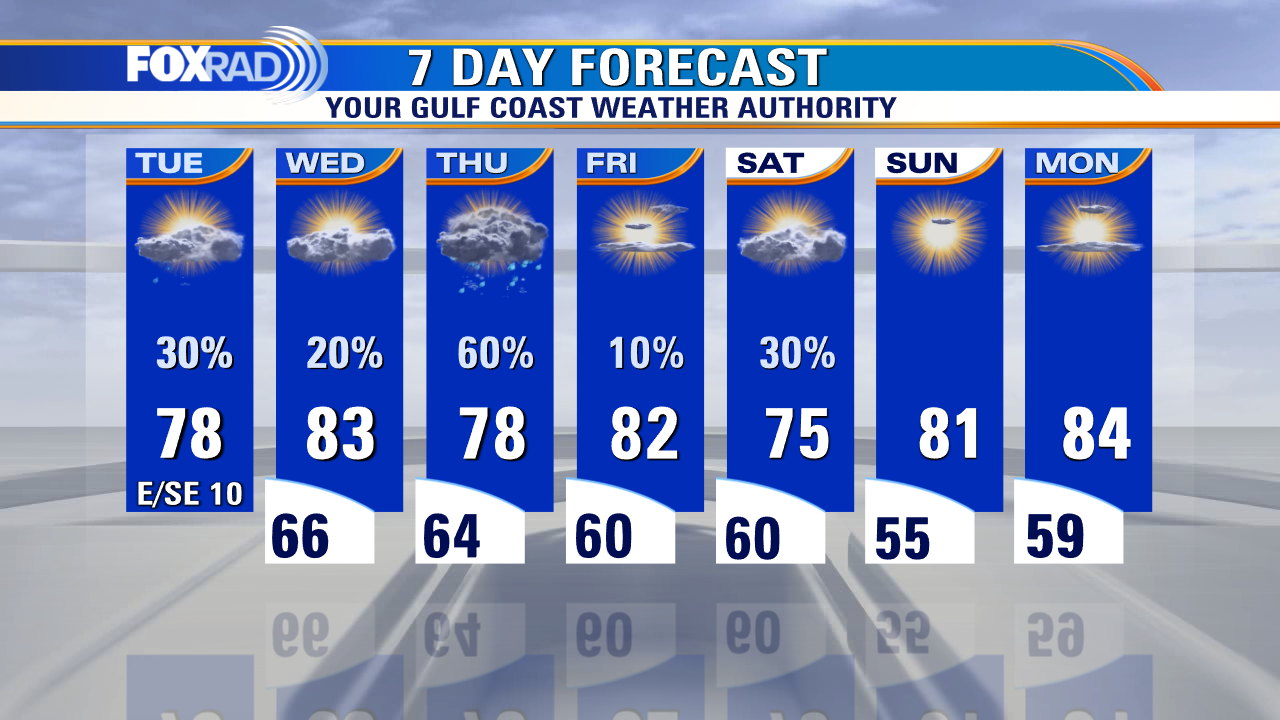
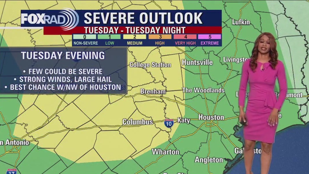
Watch out for the potential for some strong to severe storms on Tuesday with the best shot for any severe weather NW of Houston. Timing will be late Tuesday afternoon through late Tuesday night with a few damaging wind gusts and large hail possible along with some heavy rain. Models are indicating that another line of rain and strong storms could push through late Wednesday into early Thursday with a cold front. A few showers may linger Friday into early Saturday before we dry out for the remainder of the upcoming weekend. Temperatures overall will be warmer for the rest of the week with the warmest days coming on Wednesday and Friday. Make sure to download the FOX 26 Weather App to keep track of all the weather changes and any watches, warnings or advisories that we may get!
Watch out for the potential for some strong to severe storms on Tuesday with the best shot for any severe weather NW of Houston. Timing will be late Tuesday afternoon through late Tuesday night with a few damaging wind gusts and large hail possible along with some heavy rain. Models are indicating that another line of rain and strong storms could push through late Wednesday into early Thursday with a cold front. A few showers may linger Friday into early Saturday before we dry out for the remainder of the upcoming weekend. Temperatures overall will be warmer for the rest of the week with the warmest days coming on Wednesday and Friday. Make sure to download the FOX 26 Weather App to keep track of all the weather changes and any watches, warnings or advisories that we may get!

Houston weather: Stormy, wet pattern possible this week
Weather tonight should be quiet and partly cloudy with overnight lows in the 50s and 60s. Watch out for the potential for some strong to severe storms on Tuesday with the best shot for any severe weather NW of Houston. Timing will be late Tuesday afternoon through late Tuesday night with a few damaging wind gusts and large hail possible along with some heavy rain. Models are indicating that another line of rain and strong storms could push through late Wednesday into early Thursday with a cold front. A few showers may linger Friday into early Saturday before we dry out for the remainder of the upcoming weekend. Temperatures overall will be warmer for the rest of the week with the warmest days coming on Wednesday and Friday. Make sure to download the FOX 26 Weather App to keep track of all the weather changes and any watches, warnings or advisories that we may get!
Weather tonight should be quiet and partly cloudy with overnight lows in the 50s and 60s. Watch out for the potential for some strong to severe storms on Tuesday with the best shot for any severe weather NW of Houston. Timing will be late Tuesday afternoon through late Tuesday night with a few damaging wind gusts and large hail possible along with some heavy rain. Models are indicating that another line of rain and strong storms could push through late Wednesday into early Thursday with a cold front. A few showers may linger Friday into early Saturday before we dry out for the remainder of the upcoming weekend. Temperatures overall will be warmer for the rest of the week with the warmest days coming on Wednesday and Friday. Make sure to download the FOX 26 Weather App to keep track of all the weather changes and any watches, warnings or advisories that we may get!

Houston Weather: Look for several rounds of showers, storms this week
We have an interesting and somewhat difficult forecast ahead this week.
We have an interesting and somewhat difficult forecast ahead this week.

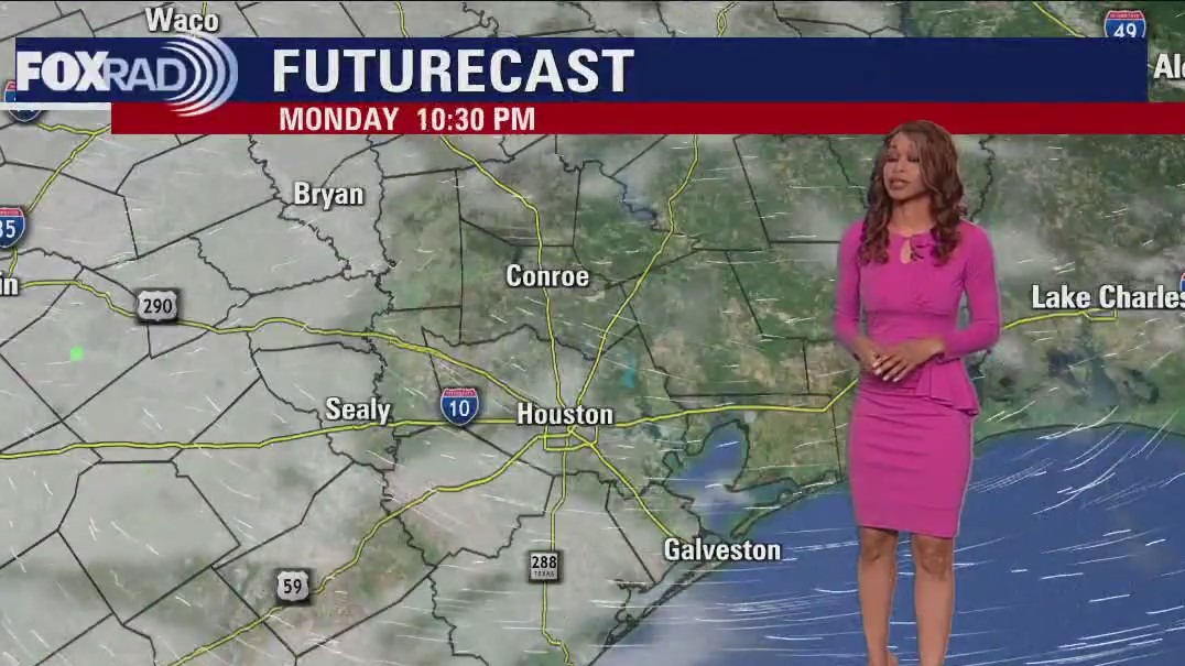
Monday afternoon weather forecast with Meteorologist John Dawson
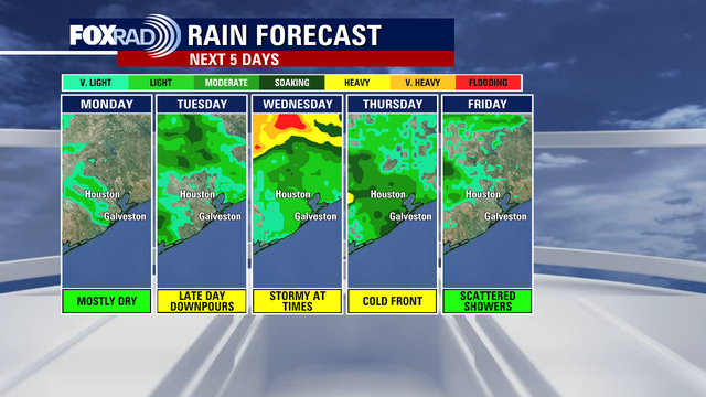
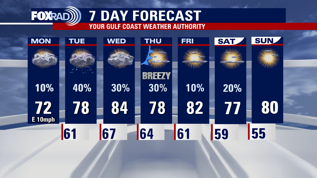
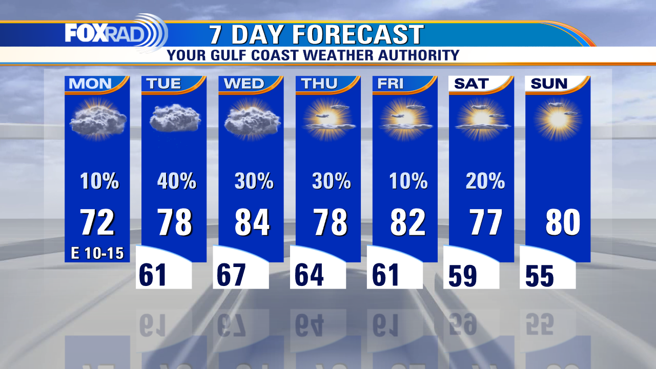
We have an interesting and somewhat difficult forecast ahead this week. We'll begin with another unusually cool day with highs about 10 degrees below average. Storms are possible tomorrow, especially west of Houston with a few possibly severe. Warmer, more humid breezes blow in Wednesday along with scattered showers. A late week front should bring more cool air by this weekend.
We have an interesting and somewhat difficult forecast ahead this week. We'll begin with another unusually cool day with highs about 10 degrees below average. Storms are possible tomorrow, especially west of Houston with a few possibly severe. Warmer, more humid breezes blow in Wednesday along with scattered showers. A late week front should bring more cool air by this weekend.


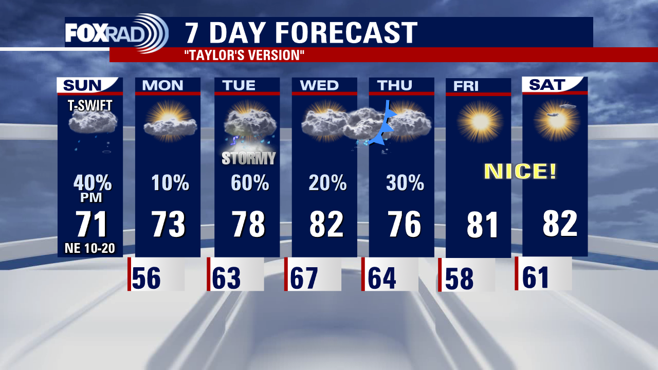
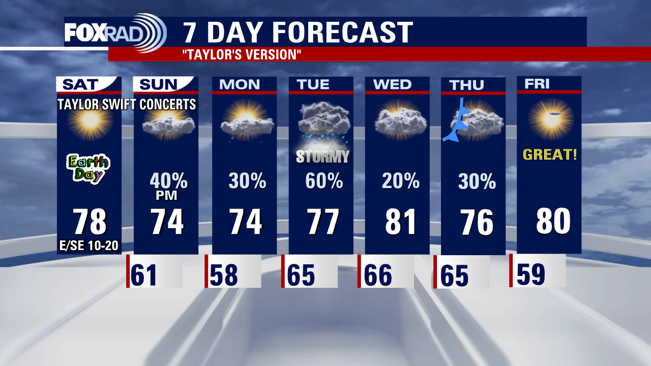
Mondays with Mike: Taylor Swift mania, mesmerizing clouds and National Bucket List Day
This week, Mike will discuss the Taylor Swift mania over the weekend, the mesmerizing clouds over Houston, and Monday, April 24 named National Bucket List Day.
This week, Mike will discuss the Taylor Swift mania over the weekend, the mesmerizing clouds over Houston, and Monday, April 24 named National Bucket List Day.

Monday morning weather forecast with Chief Meteorologist Mike Iscovitz
We have an interesting and somewhat difficult forecast ahead this week. We'll begin with another unusually cool day with highs about 10 degrees below average. Storms are possible tomorrow, especially west of Houston with a few possibly severe. Warmer, more humid breezes blow in Wednesday along with scattered showers. A late week front should bring more cool air by this weekend.
We have an interesting and somewhat difficult forecast ahead this week. We'll begin with another unusually cool day with highs about 10 degrees below average. Storms are possible tomorrow, especially west of Houston with a few possibly severe. Warmer, more humid breezes blow in Wednesday along with scattered showers. A late week front should bring more cool air by this weekend.

Houston weather: Cool temps Sunday evening, forecast for the work week
Houston can expect mostly dry conditions on Monday with storms returning to the forecast late on Tuesday. A front arrives to southeast Texas Wednesday night clearing the skies for the weekend.
Houston can expect mostly dry conditions on Monday with storms returning to the forecast late on Tuesday. A front arrives to southeast Texas Wednesday night clearing the skies for the weekend.

Cloudy, cool Sunday evening with temps in 60s
Houston can expect mostly dry conditions on Monday with storms returning to the forecast late on Tuesday. A front arrives in southeast Texas Wednesday night clearing the skies for the weekend.
Houston can expect mostly dry conditions on Monday with storms returning to the forecast late on Tuesday. A front arrives in southeast Texas Wednesday night clearing the skies for the weekend.

El Tiempo 23 de Abril de 2023
#FOX26 Meteor�loga Lena Maria Arango tiene su pron�stico para la semana laboral.
#FOX26 Meteor�loga Lena Maria Arango tiene su pron�stico para la semana laboral.

Sunday weather forecast with Meteorologist Lena Maria Arango
After a glorious Saturday, the weekend takes a turn to the unsettled side with a mostly cloudy, cool gray day on tap for Sunday. Be on the lookout for a few isolated showers for most, southwest could get clipped by strong to severe storms. Monday looks quiet and mostly dry, but then several rounds of rain and storms push through midweek before finally clearing out as we roll into the weekend!
After a glorious Saturday, the weekend takes a turn to the unsettled side with a mostly cloudy, cool gray day on tap for Sunday. Be on the lookout for a few isolated showers for most, southwest could get clipped by strong to severe storms. Monday looks quiet and mostly dry, but then several rounds of rain and storms push through midweek before finally clearing out as we roll into the weekend!
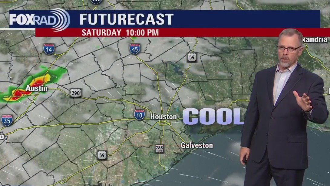

Party cloudy, warm Saturday evening in the 70s
We end the weekend with more clouds and the possibility of some showers across Houston. Rain chances remain in the forecast most of the week with the highest chances on Tuesday. Southeast Texas should see another weak cold front move through at the end of the week clearing skies for next weekend.
We end the weekend with more clouds and the possibility of some showers across Houston. Rain chances remain in the forecast most of the week with the highest chances on Tuesday. Southeast Texas should see another weak cold front move through at the end of the week clearing skies for next weekend.

Saturday weather forecast with Meteorologist Lena Maria Arango
Days like today are going to be harder and harder to come by in southeast Texas, so enjoy it in all of it's glory! Tomorrow afternoon through most of the week features on and off showers and storms as a series of disturbances move their way across the area. While it won't be raining all the time, the pattern overall looks more wet than dry. Our next beautiful day to look forward to at this point looks to be Friday!
Days like today are going to be harder and harder to come by in southeast Texas, so enjoy it in all of it's glory! Tomorrow afternoon through most of the week features on and off showers and storms as a series of disturbances move their way across the area. While it won't be raining all the time, the pattern overall looks more wet than dry. Our next beautiful day to look forward to at this point looks to be Friday!