


FOX 26 Houston Weather Forecast
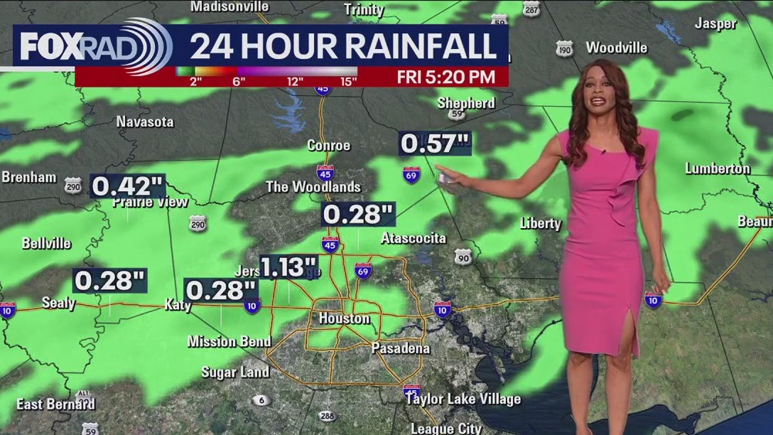
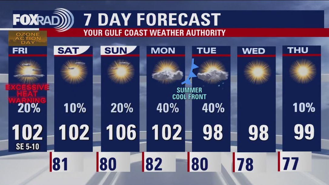
VERY hot today with late day isolated storms mainly north of I-10, a few of which may be on the strong side. Scattered showers continue area-wide tomorrow as a weak summer front progresses across the area. That'll lower temps and humidity some for the remainder of the week, with mainly pleasant mornings to look forward to. All eyes on the Eastern Gulf with now TD-10 set to bring impacts to Florida in the Tuesday-Wednesday time frame.


FOX 26 Saturday evening weather forecast
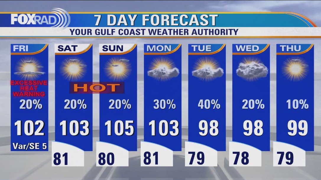
The heat should still be the main focus for Houston this weekend but the chance for rain is certainly a distraction from the Excessive Heat Warning. Look for a few showers late on Sunday with another shot or two on Monday as a weak summer front moves through southeast Texas. Upper 90s replace the triple digits in the afternoons for the rest of the week. In the tropics, all eyes are on the Eastern Gulf of Mexico for a tropical storm or hurricane to form heading towards Florida.


Tropical Weather Forecast - August 26, 2023
Tropical Depression Ten has form and will be headed to Florida this week. Franklin is now a hurricane and expected to organize into a major hurricane this week.


Fan battling high temperatures at high school football games
Fan battling high temperatures at high school football games


Texas power grid: ERCOT issues conservation appeal for Saturday, August 26
Similar to Friday, Saturday’s conservation appeal does not indicate ERCOT is experiencing emergency conditions at this time. Current forecasts are showing a potential to enter emergency operations this evening because of expected low wind and potential low solar generation and high demand.

FOX 26 Houston Weather Forecast
Live & breaking news for the entire Houston area.


Tropical Weather Forecast - August 25, 2023
Trouble could be brewing for the eastern Gulf of Mexico. Invest 93-L is now over the NW Caribbean with a high 80% chance to develop into a tropical system over the next 7 days. It should pass through the Yucatan Channel this weekend and emerge into the eastern Gulf of Mexico Monday. Models take it up towards the northern Florida Coast by Tuesday. Tropical Storm Franklin is expected to grow into a hurricane early next week as it brushes by Bermuda. A few other tropical waves in the central Atlantic are being monitored for development.


Houston drought: Areas of Missouri City to be under mandatory water conservation
Certain areas in Missouri City will be under a mandatory water conservation starting on Monday. See if your area is affected.

FOX 26 Friday evening weather forecast
Excessive Heat Warning continues for Houston until 9 PM with a Heat Advisory in place through Saturday evening. More triple digit heat is likely through the weekend and into Monday with only a slim shot for rain. Heat dome will try to slide west through early next week which will allow a weak summer cold front to try to push in Monday and Tuesday. This should knock temperatures back down below 100 and increase our rain chances. We will also be closely watching invest 93-L in the NW Caribbean. It is forecast to track into the eastern Gulf of Mexico by Monday and has a high chance to develop into a tropical depression or storm early next week. It will likely head towards Florida.


Houston heat slows business at restaurants
Scorching temperatures are taking a toll on restaurants, especially those designed to cater to outside customers. They're finding fewer people are interested in venturing out in the lingering summer heat. FOX 26's Tom Zizka has more on the story.


Louisiana officials ask people to stop battling massive wildfire with personal hoses
The 12,000-acre wildfire prompted officials to issue mandatory evacuations for parts of Louisiana.

FOX 26 Houston Weather Forecast
Following an all-time record high on 109 in Houston yesterday, today will be very hot again, but with a southeast wind, likely in the 100-104 range - still in record territory. For the weekend, expect more baking temps in the 103-105 range with only isolated afternoon rain possible. Our best chance for a slight cool-down will be early next week with the arrival of front and a shifting of the "heat dome"

FOX 26 Houston Weather Forecast
Following an all-time record high of 109 in Houston yesterday, today will be very hot again, but with a southeast wind, likely in the 100-104 range - still in record territory. For the weekend, expect more baking temps in the 103-105 range with only isolated afternoon rain possible. Our best chance for a slight cool-down will be early next week with the arrival of front and a shifting of the "heat dome"
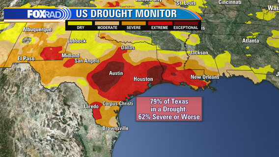

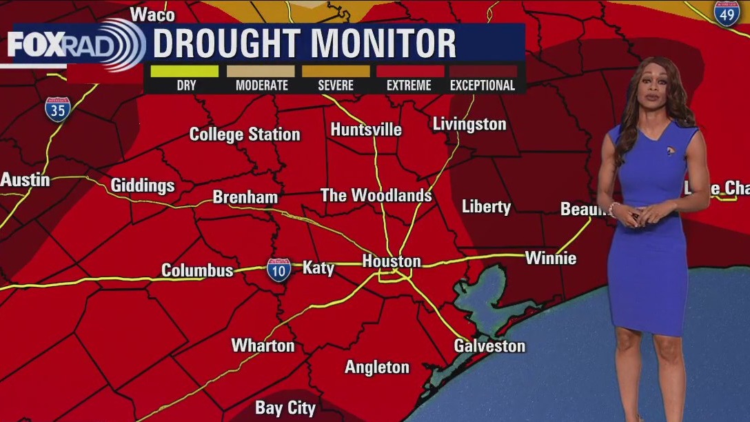
Houston weather: The worst drought in 12 years
According to the latest U.S. Drought Monitor maps, our entire area is classified as being under either an extreme or exceptional drought.


Houston residents wait almost week for city to fix ruptured water line in neighborhood
One southwest Houston neighborhood wants to see a water gusher being fixed amid upcoming Stage 2 water restrictions.


Tropical Weather Forecast - August 24, 2023
We are about a week away from the month of September which is the typical peak of hurricane season. As expected, the tropics are heating up with several systems I'm monitoring. There's an area of low pressure over Central America that could track into the NW Caribbean and eventually the eastern Gulf of Mexico early next week. Tropical Storm Franklin is east of the Turks and Caicos Islands and will develop into a hurricane as it gets close to Bermuda early next week. Two additional tropical waves in the eastern & central Atlantic will need to be watched as they both have a medium chance for development.

FOX 26 Thursday evening weather forecast
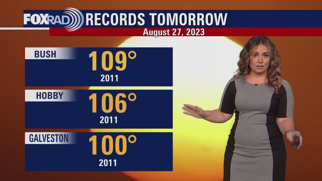
Records have been shattered with some of the hottest temperatures of all time and of the summer today across Houston and surrounding areas! So far, we've made it up to 109 degrees in Houston today which ties our all-time record high temperature for Bush Airport! Galveston reached 99 so far which is the hottest temperature of the year and a record for today. Isolated showers and storms are possible through this evening which may provide some relief. Excessive heat warning is in effect for Houston until 10 PM followed by a Heat Advisory through 9 PM Friday. Look for more 100-degree heat through early next week before a slight pattern change. This change will mean temps a bit below 100 and a better chance for spotty rain and storms. Be careful in the heat!


Houston officials call for conservation
As the blistering heat continues on for yet another day, the extreme temperatures are impacting the way Texans live and operate. Officials now asking residents to conserve both energy and water. FOX 26's Natalie Hee explains more.


ERCOT issues Conservation Appeal for Thursday; what should you know?
ERCOT is not experiencing emergency conditions at this time, but forecasts are showing a high potential to enter emergency operations. Help from Texans to conserve electricity use will assist grid reliability.
Houston drought: Pasadena asks residents to voluntarily conserve water
The City of Pasadena is asking residents to voluntarily conserve water due to the ongoing, extreme high temperatures.