


100-year-old oak tree falls on Florida Gov. Ron DeSantis' mansion in wake of Hurricane Idalia
Casey DeSantis shared a photo of a 100-year-old oak tree that fell on the Governor's Mansion in Tallahassee in the wake of Hurricane Idalia.


Water main break at Chimney Rock Rd. and W. Belfort Ave.
SkyFOX captured a water main break that occurred at Chimney Rock Road and W. Belfort Ave.


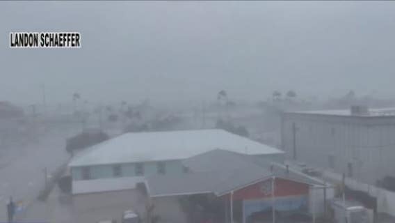
'St. Elmo's fire' seen in crazy Air Force video
An electrically charged sky gave U.S. Air Force pilots a rare light show while evacuating planes in Florida ahead of Hurricane Idalia.

FOX 26 Houston Weather Forecast
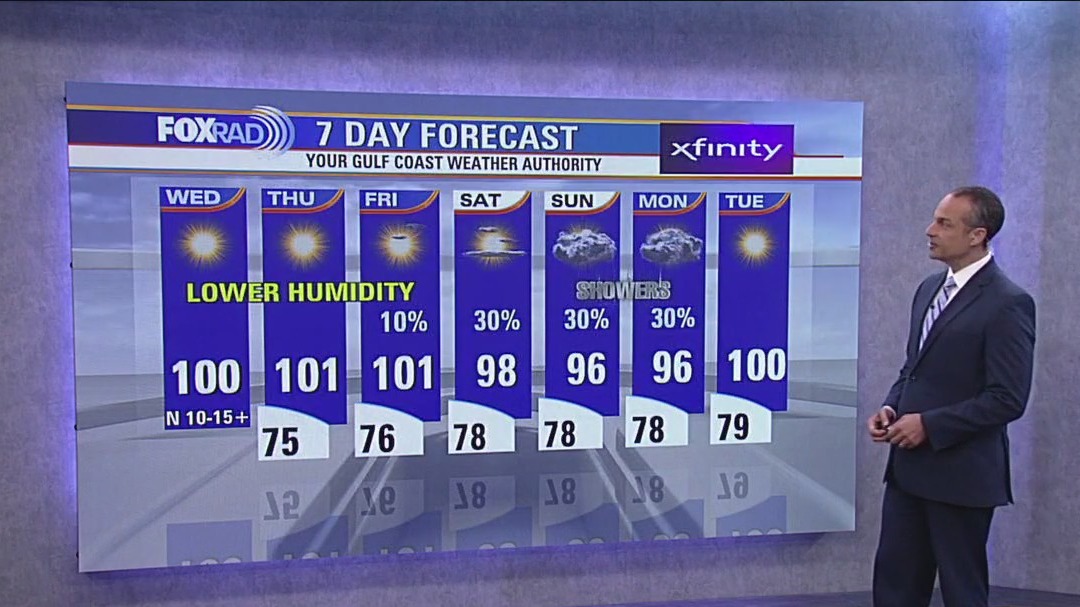
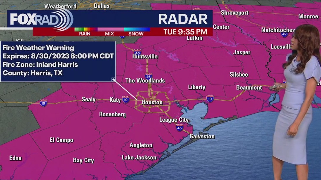
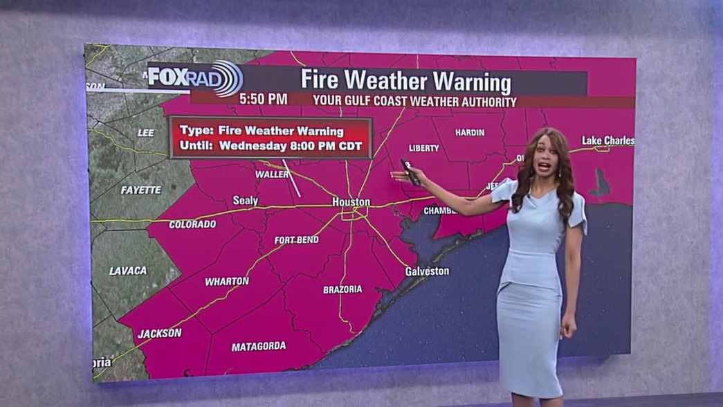
Sunny, hot and less humid with highs near 100. A ?red flag warning? is in effect due to increased risk for wildfires.


Hurricane Idalia tracking to Florida landfall as dangerous Category 4 storm
The time to prepare is over and a dire situation is unfolding along Florida’s Gulf Coast as Category 4 Hurricane Idalia continues to rapidly intensify in the Gulf of Mexico. Catastrophic, life-threatening storm surge and destructive winds will pound the state’s Big Bend region as the monster storm nears the coast just hours away from landfall.

FOX 26 Houston Weather Forecast
All eyes are on Hurricane Idalia as it nears the Florida west coast. Idalia is expected to make landfall around the Big Bend of Florida Wednesday morning as a major category three hurricane. Idalia will bring the threat for storm surge up to 15 feet, coastal flooding, tornadoes, & damaging winds over 100 mph. We will be on the western side of Idalia which means northerly winds and mainly dry weather the next few days. But with dry weather & very low humidity, our fire danger increases. So a red flag warning is in place 10 AM - 8 PM Wednesday. Air quality alert for higher ozone levels will stick around through Wednesday evening as well. Temperatures will be near 100 through Friday with lower humidity. Look for rain chances to return this weekend and temperatures to drop back to the middle to upper 90s.


Tropical Weather Forecast - August 29, 2023
Idalia is getting closer to Florida and is now a Category two hurricane with winds of 100 mph. It is still expected to bring a big flood threat, storm surge risk, damaging wind risk and tornado threat to a big portion of Florida, especially the Florida Big Bend. Landfall is likely Wednesday morning as a major Category three hurricane with 125 mph winds around the Big Bend of Florida. Tropical storm conditions are expected all the way over to Jacksonville and eventually up around the Carolinas where Tropical Storm Warnings are in place. Franklin is still a major hurricane that will pass west of Bermuda where Tropical Storm warnings are in place. Tropical Depression 11 has formed in the central Atlantic. There's also a tropical wave near the west coast of Africa with a medium chance for development over the next week. Stay alert as we are now in the busiest part of hurricane season!


Hurricane Idalia: Governor Abbott deploys hurricane resources to Florida
Texas Governor Greg Abbott has sent resources to aid Florida as Hurricane Idalia is set to make landfall on Wednesday.


Hurricane Idalia, Hurricane Franklin put on powerful show as seen from space
Satellite imagery from NOAA showed the power of Hurricane Idalia and Hurricane Franklin at sunrise on Tuesday morning.

FOX 26 Tuesday morning weather forecast
As Hurricane Idalia lashes Florida, the storm will actually help to reinforce north breezes for the Houston area, so our humidity should drop a bit over the next couple of days. Otherwise, we will stay hot with highs near 100, but heat alerts are not likely due to drier air.


Floridians preparing for Hurricane Idalia
Idalia has strengthened into a hurricane with 13 million Floridians under weather watches and warnings and people in nearly two dozen coastal counties told to evacuate. Forecasters expect the storm to keep gaining strength. FOX News Correspondent Rebekah Castor has more from Pinellas County, Florida.

Houston-area storm chasers driving to Florida for Idalia landfall
A group of Houston-area meteorologists are heading down to Florida for Idalia's landfall, which is expected later in the week.

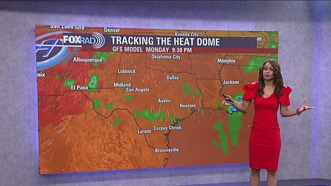
FOX 26 Houston Weather Forecast
A low rain chance is possible on Tuesday, but after that, we dry things out for a few days with spotty rain and storms possible again by the weekend. Temperatures will still be hot near 100 this week, but humidity will be a bit lower.


Florida prepares for arrival of Tropical Storm Idalia, which is forecast to become a major hurricane
Florida residents are evacuating from homes in low-lying areas along the Gulf Coast as forecasters predict that Tropical Storm Idalia will hit the state as a major hurricane by Wednesday.


Maui wildfires: Uber, Spam, Airbnb to support displaced locals
Death toll in Maui has surpassed 100

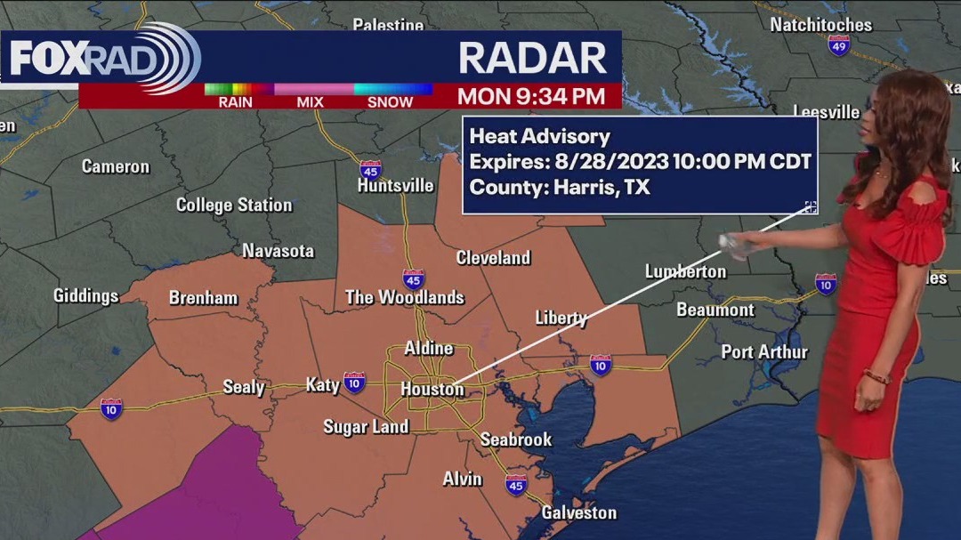
FOX 26 Houston Weather Forecast
Heat Advisory remains in place for Houston and much of SE Texas until 10 PM tonight. Excessive Heat Warning is in effect for Wharton, Jackson & Matagorda counties until 10 PM. Heat index values could still be 108+ through the evening so be careful not to overdo it as you enjoy some time outside. There's still a shot for a few showers and storms to develop this evening and tonight with a low rain chance Tuesday as well. After that we dry things out for a few days with spotty rain and storms possible again by the weekend. Temperatures will still be hot near 100 this week but humidity will be a bit lower.


Fort Bend County: Missouri City implements mandatory water conservation amid drought conditions
The City of Missouri City is issuing a water conservation in some areas of the city due to drought conditions worsening.


Tropical Weather Forecast - August 28, 2023
Idalia is close to becoming a hurricane today and is expected to strengthen to a major Category three hurricane by early Wednesday. Hurricane warnings are in place for parts of the Florida Gulf Coast, including Tampa Bay. Idalia is projected to make landfall around the Big Bend of Florida Wednesday morning bringing up to a foot of rain, storm surge up to 7-11 feet NW of Tampa, damaging winds & the threat for tornadoes. Hurricane Franklin has grown into a dangerous category 4 hurricane in the western Atlantic. It should remain over water but will get close to Bermuda early Wednesday where Tropical Storm Watches are in effect. Another tropical wave coming off the coast of Africa has a medium chance to develop into a tropical system over the next week.


Mondays with Mike: Hurricane Franklin & watching Idalia
Hurricane Franklin is exploding in the Atlantic, and Idalia is a big threat for Florida.