


Watching Kirk and T.D. #13 | FOX 26 Tropical Weather Forecast
Tropics remain fairly active across the Atlantic basin with a hurricane, tropical depression and a disturbance with the potential for tropical development. Hurricane Kirk is in the central Atlantic and is expected to become a major hurricane by Thursday. It is forecast to turn northeast by this weekend and should remain out over water. Invest 91-L in the far east Atlantic is now Tropical Depression 13. This system is expected to become Tropical Storm Leslie very soon and hurricane Leslie by Saturday. This tropical system is also expected to remain over water. NHC is still giving a broad trough of low pressure from the SW Caribbean to the southern Gulf of Mexico a MEDIUM 40% chance for development. Models are not showing any significant development in the Gulf but a weaker system could still form. Regardless, plume of tropical moisture is likely to push towards the Gulf coast this weekend increasing rain chances. Download FOX LOCAL for the latest on what's happening in the tropics!
Tropics remain fairly active across the Atlantic basin with a hurricane, tropical depression and a disturbance with the potential for tropical development. Hurricane Kirk is in the central Atlantic and is expected to become a major hurricane by Thursday. It is forecast to turn northeast by this weekend and should remain out over water. Invest 91-L in the far east Atlantic is now Tropical Depression 13. This system is expected to become Tropical Storm Leslie very soon and hurricane Leslie by Saturday. This tropical system is also expected to remain over water. NHC is still giving a broad trough of low pressure from the SW Caribbean to the southern Gulf of Mexico a MEDIUM 40% chance for development. Models are not showing any significant development in the Gulf but a weaker system could still form. Regardless, plume of tropical moisture is likely to push towards the Gulf coast this weekend increasing rain chances. Download FOX LOCAL for the latest on what's happening in the tropics!


Biden visits North Carolina Wednesday amid Hurricane Helene devastation
Hurricane Helene’s remnants have caused catastrophic damage across the Southeast.
Hurricane Helene’s remnants have caused catastrophic damage across the Southeast.


Dad treks miles through Hurricane Helene aftermath to walk daughter down aisle
David Jones walked for 5 1/2 hours through flood damage in South Carolina to make his daughter's wedding in Tennessee.
David Jones walked for 5 1/2 hours through flood damage in South Carolina to make his daughter's wedding in Tennessee.

Helene devastation and portable power station
In this Forecasting with Friends, Chief Meteorologist Mike Iscovitz and meteorologist John Dawson look at the devastation left behind by Hurricane Helene and show you the Duracell portable power station, which you can use in case of natural disaster.
In this Forecasting with Friends, Chief Meteorologist Mike Iscovitz and meteorologist John Dawson look at the devastation left behind by Hurricane Helene and show you the Duracell portable power station, which you can use in case of natural disaster.


Investigators probe Tennessee plastics factory after deaths during Helene flooding
Tennessee state authorities are investigating the company behind a plastics factory where 11 workers were swept away in Hurricane Helene floodwaters. Two died, and five are still missing.
Tennessee state authorities are investigating the company behind a plastics factory where 11 workers were swept away in Hurricane Helene floodwaters. Two died, and five are still missing.

Weekend storms possible | Fox 26 Houston Weather Forecast
Our early fall heat wave will continue today with more highs in the low to mid 90s. Expect plenty of sunshine today and Thursday with decent humidity, but high temperatures running about 5-7 degrees above average. Rain chances will increase beginning Friday and for most of Saturday as we'll end up on the edge of a plume of tropical moisture from the Gulf of Mexico. Watch for storms, especially near the coast, but no organized tropical systems are headed our way. As mentioned over the last few days, conditions in the Gulf are messy and chaotic, so one or two areas of low pressure may come together and become tropical depressions or even a tropical storm over the next 7 days - the highest chance for any impacts from those systems would be along the Gulf coast of Mexico and also in Florida. Meanwhile in the middle of the Atlantic, hurricane Kirk is gaining strength, but not threatening land. Leslie could form inthe wake of Kirk, but also will not affect land.
Our early fall heat wave will continue today with more highs in the low to mid 90s. Expect plenty of sunshine today and Thursday with decent humidity, but high temperatures running about 5-7 degrees above average. Rain chances will increase beginning Friday and for most of Saturday as we'll end up on the edge of a plume of tropical moisture from the Gulf of Mexico. Watch for storms, especially near the coast, but no organized tropical systems are headed our way. As mentioned over the last few days, conditions in the Gulf are messy and chaotic, so one or two areas of low pressure may come together and become tropical depressions or even a tropical storm over the next 7 days - the highest chance for any impacts from those systems would be along the Gulf coast of Mexico and also in Florida. Meanwhile in the middle of the Atlantic, hurricane Kirk is gaining strength, but not threatening land. Leslie could form inthe wake of Kirk, but also will not affect land.

Talking Hurricane Helene's rainfall and more!
Join FOX 26 Chief Meteorologist Mike Iscovitz and Meteorologist John Dawson as they discuss the the damage left behind by Hurricane Helene and more!
Join FOX 26 Chief Meteorologist Mike Iscovitz and Meteorologist John Dawson as they discuss the the damage left behind by Hurricane Helene and more!

FOX 26 Houston Weather Forecast
Summer heat is hanging on into the beginning of October! High temperatures should stay in the 90s for most through the end of the work week. Tropical moisture increases late week with the best rain chances coming in Friday and Saturday. Hurricane Kirk should become a Category 3 by Thursday but is not expected to be a threat to land. Tropical wave Invest 91-L in the eastern Atlantic has a high chance to become Tropical Storm or Hurricane Leslie. Large area from SW Caribbean to southern Gulf is being monitored for tropical development. At this point models are not showing a major tropical system developing but a few disturbances are possible that could bring heavy rain to parts of the Gulf coast. Keep checking back for updates and get a daily detailed tropical update on FOX Local, our free smart tv app!
Summer heat is hanging on into the beginning of October! High temperatures should stay in the 90s for most through the end of the work week. Tropical moisture increases late week with the best rain chances coming in Friday and Saturday. Hurricane Kirk should become a Category 3 by Thursday but is not expected to be a threat to land. Tropical wave Invest 91-L in the eastern Atlantic has a high chance to become Tropical Storm or Hurricane Leslie. Large area from SW Caribbean to southern Gulf is being monitored for tropical development. At this point models are not showing a major tropical system developing but a few disturbances are possible that could bring heavy rain to parts of the Gulf coast. Keep checking back for updates and get a daily detailed tropical update on FOX Local, our free smart tv app!

FOX 26 Houston Weather Forecast
Summer heat is hanging on into the beginning of October! High temperatures should stay in the 90s for most through the end of the work week. Tropical moisture increases late week with the best rain chances coming in Friday and Saturday. Hurricane Kirk should become a Category 3 by Thursday but is not expected to be a threat to land. Tropical wave Invest 91-L in the eastern Atlantic has a high chance to become Tropical Storm or Hurricane Leslie. Large area from SW Caribbean to southern Gulf is being monitored for tropical development. At this point models are not showing a major tropical system developing but a few disturbances are possible that could bring heavy rain to parts of the Gulf coast. Keep checking back for updates and get a daily detailed tropical update on FOX Local, our free smart TV app!
Summer heat is hanging on into the beginning of October! High temperatures should stay in the 90s for most through the end of the work week. Tropical moisture increases late week with the best rain chances coming in Friday and Saturday. Hurricane Kirk should become a Category 3 by Thursday but is not expected to be a threat to land. Tropical wave Invest 91-L in the eastern Atlantic has a high chance to become Tropical Storm or Hurricane Leslie. Large area from SW Caribbean to southern Gulf is being monitored for tropical development. At this point models are not showing a major tropical system developing but a few disturbances are possible that could bring heavy rain to parts of the Gulf coast. Keep checking back for updates and get a daily detailed tropical update on FOX Local, our free smart TV app!

Western Caribbean being watched for development
Atlantic Basin remains busy and fired up to kick off the month of October. There's Hurricane Kirk in the east-central Atlantic. It is forecast to become a major hurricane by Thursday. The good news is that it is not expected to be a threat to land. A tropical wave in the eastern Atlantic, Invest 91-L has a high chance to become our next tropical system. Next two names are Leslie and Milton. A disturbance in the western Caribbean is being monitored for tropical development over the next week. Chance is a MEDIUM 40% shot. This area of disturbed weather could drift into the Gulf of Mexico by this weekend. Models are showing another increase in tropical moisture heading our way this weekend but no organized tropical system coming here just yet. Keep checking back for updates!
Atlantic Basin remains busy and fired up to kick off the month of October. There's Hurricane Kirk in the east-central Atlantic. It is forecast to become a major hurricane by Thursday. The good news is that it is not expected to be a threat to land. A tropical wave in the eastern Atlantic, Invest 91-L has a high chance to become our next tropical system. Next two names are Leslie and Milton. A disturbance in the western Caribbean is being monitored for tropical development over the next week. Chance is a MEDIUM 40% shot. This area of disturbed weather could drift into the Gulf of Mexico by this weekend. Models are showing another increase in tropical moisture heading our way this weekend but no organized tropical system coming here just yet. Keep checking back for updates!

Tropical storms forming | Fox 26 Houston Weather Forecast
After record or near record highs on Monday, today will bring more hot sunshine with highs in the mid 90s. Rain looks unlikely until the Friday-Saturday time frame when we'll have a combination of a cold front moving in and a plume of tropical moisture nearby. The timing and location is uncertain, but we'll keep an eye on Saturday as having our best rain chances. As far as tropical development, the Gulf of Mexico looks like it will be somewhat unsettled and chaotic for the next week or so. There will be several areas of stormy weather and an occasional small low forming - when all is said and done, there is a good chance for a tropical depression or possible storm in the central Gulf, but it doesn't look like it would move toward the Houston area. Elsewhere in the Atlantic Ocean, Kirk formed yesterday and will become the season's next hurricane with another wave possibly becoming Leslie today or tomorrow. Neither is a threat to land.
After record or near record highs on Monday, today will bring more hot sunshine with highs in the mid 90s. Rain looks unlikely until the Friday-Saturday time frame when we'll have a combination of a cold front moving in and a plume of tropical moisture nearby. The timing and location is uncertain, but we'll keep an eye on Saturday as having our best rain chances. As far as tropical development, the Gulf of Mexico looks like it will be somewhat unsettled and chaotic for the next week or so. There will be several areas of stormy weather and an occasional small low forming - when all is said and done, there is a good chance for a tropical depression or possible storm in the central Gulf, but it doesn't look like it would move toward the Houston area. Elsewhere in the Atlantic Ocean, Kirk formed yesterday and will become the season's next hurricane with another wave possibly becoming Leslie today or tomorrow. Neither is a threat to land.


Join the effort: How you can help Hurricane Helene's devastated communities
Relief efforts are underway, with government agencies and aid organizations like the American Red Cross, Samaritan's Purse, and the Salvation Army providing assistance.
Relief efforts are underway, with government agencies and aid organizations like the American Red Cross, Samaritan's Purse, and the Salvation Army providing assistance.

Hurricane Helene?s toll: 100+ dead | Forecasting with Friends
Hurricane Helene has left a trail of destruction, with the death toll now surpassing 100 people. Mike Iscovitz breaks down the storm?s devastating impact, starting with Florida.
Hurricane Helene has left a trail of destruction, with the death toll now surpassing 100 people. Mike Iscovitz breaks down the storm?s devastating impact, starting with Florida.

Hurricane update and behind the scenes with Mike
Today, Chief meteorologist Mike Iscovitz Has the latest on Helene and new developments in the tropics plus a behind the scenes view of our daily 11am weather show Forecasting with Friends.
Today, Chief meteorologist Mike Iscovitz Has the latest on Helene and new developments in the tropics plus a behind the scenes view of our daily 11am weather show Forecasting with Friends.


Tropical Storm Kirk forms, forecast to become large, powerful hurricane this week: NHC
Tropical Storm Kirk (formerly Tropical Depression 12) formed over the Atlantic Ocean Monday morning and is forecast to become a "large and powerful hurricane" later this week, the National Hurricane Center said.
Tropical Storm Kirk (formerly Tropical Depression 12) formed over the Atlantic Ocean Monday morning and is forecast to become a "large and powerful hurricane" later this week, the National Hurricane Center said.

Duracell portable power station | Hurricane Gear Test
When a hurricane hits, losing power can make it tough to keep your devices charged. Join Meteorologist John Dawson today as he tests a portable power station designed to keep you prepared when the lights go out!
When a hurricane hits, losing power can make it tough to keep your devices charged. Join Meteorologist John Dawson today as he tests a portable power station designed to keep you prepared when the lights go out!

Sunny and hot here | Fox 26 Houston Weather Forecast
Lots to watch in the world of weather, but most of it isn't here. We're still in our sunny, hot and dry pattern with mild mornings and afternoon highs close to records. Air quality on sunny, calm and dry days like today tend to produce ozone, so if you are very sensitive to air pollution, don't exert yourself outdoors this afternoon. There are currently three tropical systems in the Atlantic Ocean, but none are near land and should not be a concern. A tropical disturbance near the Yucatan and a general messy, unsettled pattern will form over the Gulf of Mexico over the next 7 days (at least). It does not look like the steering currents would favor anything having an impact in Texas, but we'll watch it closely. Florida could see another (less intense) tropical system from the Gulf late this week.
Lots to watch in the world of weather, but most of it isn't here. We're still in our sunny, hot and dry pattern with mild mornings and afternoon highs close to records. Air quality on sunny, calm and dry days like today tend to produce ozone, so if you are very sensitive to air pollution, don't exert yourself outdoors this afternoon. There are currently three tropical systems in the Atlantic Ocean, but none are near land and should not be a concern. A tropical disturbance near the Yucatan and a general messy, unsettled pattern will form over the Gulf of Mexico over the next 7 days (at least). It does not look like the steering currents would favor anything having an impact in Texas, but we'll watch it closely. Florida could see another (less intense) tropical system from the Gulf late this week.
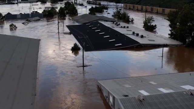

Helene latest: 84 dead, over 1,000 people unaccounted for in western NC
The death toll continues to climb and some 2.5 million people remained without power Sunday as recovery in the Southeast US begins from devastating Hurricane Helene.
The death toll continues to climb and some 2.5 million people remained without power Sunday as recovery in the Southeast US begins from devastating Hurricane Helene.


Houston Texans donate $1 million to Hurricane Helene relief efforts
The Houston Texans have announced a $1 million donation to aid relief efforts for those affected by Hurricane Helene.
The Houston Texans have announced a $1 million donation to aid relief efforts for those affected by Hurricane Helene.

Isaac, Joyce weaken as new storms form | Tropical Update
Atlantic basin remains super active with 5 systems that we are closely tracking. Tropical Storm Isaac and Tropical Storm Joyce are still churning in the central Atlantic but are expected to stay out to sea and gradually weaken. A tropical wave being monitored in the eastern Atlantic is now Tropical Depression 12. This system will likely become tropical storm Kirk soon. Another tropical wave near the west coast of Africa has a low 30% chance to become a tropical system over the next 7 days. A broad area of low pressure has formed in the western Caribbean and NHC says a tropical depression or storm could form over the seven days. This system is expected to push into the Gulf of Mexico by the end of the week. So keep checking back for the latest updates!
Atlantic basin remains super active with 5 systems that we are closely tracking. Tropical Storm Isaac and Tropical Storm Joyce are still churning in the central Atlantic but are expected to stay out to sea and gradually weaken. A tropical wave being monitored in the eastern Atlantic is now Tropical Depression 12. This system will likely become tropical storm Kirk soon. Another tropical wave near the west coast of Africa has a low 30% chance to become a tropical system over the next 7 days. A broad area of low pressure has formed in the western Caribbean and NHC says a tropical depression or storm could form over the seven days. This system is expected to push into the Gulf of Mexico by the end of the week. So keep checking back for the latest updates!