


Houston weather: Slight chance of showers on Mother's Day
FOX 26 meteorologist Remeisha Shade has the details on the chance of showers on Mother's Day, plus temperature heating up later this week.
FOX 26 meteorologist Remeisha Shade has the details on the chance of showers on Mother's Day, plus temperature heating up later this week.

Houston weather: Slight rain chance for Mother's Day, warm up on the way
It should be a pleasant Mother's Day weekend outside a few scattered showers and drizzles.
It should be a pleasant Mother's Day weekend outside a few scattered showers and drizzles.

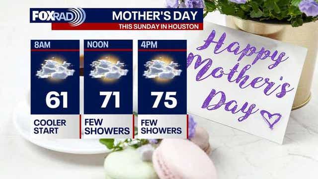
Houston weather: Slight storm chances for Mother's Day weekend
Expect spotty showers Saturday night, light rain on Sunday, and highs in the 90s this upcoming week.
Expect spotty showers Saturday night, light rain on Sunday, and highs in the 90s this upcoming week.


4.1-magnitude earthquake hits Tennessee, felt in Atlanta
A 4.1-magnitude earthquake struck Tennessee Saturday morning and was felt as far as Atlanta and western North Carolina.
A 4.1-magnitude earthquake struck Tennessee Saturday morning and was felt as far as Atlanta and western North Carolina.

Houston weather: Scattered storms on Saturday
FOX 26 meteorologist Allison Gargaro takes a look at the weather this Mother's Day weekend, including scattered showers on Saturday.
FOX 26 meteorologist Allison Gargaro takes a look at the weather this Mother's Day weekend, including scattered showers on Saturday.
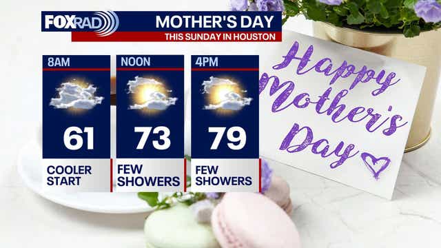

Houston weather: Mother's Day weekend forecast
Saturday will feature mostly sunny skies in the morning, with a chance of showers and thunderstorms developing in the afternoon. We've added a slight chance for a light shower on Sunday.
Saturday will feature mostly sunny skies in the morning, with a chance of showers and thunderstorms developing in the afternoon. We've added a slight chance for a light shower on Sunday.

Houston weather: Mother's Day weekend forecast
Here's what to expect in Houston this weekend.
Here's what to expect in Houston this weekend.


Hurricane Hunters fly into world's worst weather; see which storm was the bumpiest
Hurricane Ian in 2022 provided some of the most striking data for the one-of-a-kind study, but it wasn't at the top of the list.
Hurricane Ian in 2022 provided some of the most striking data for the one-of-a-kind study, but it wasn't at the top of the list.


Acting FEMA director replaced after saying he doesn't want to dismantle agency
The acting administrator of the Federal Emergency Management Agency has been replaced after testifying that he didn’t want to see the agency eliminated.
The acting administrator of the Federal Emergency Management Agency has been replaced after testifying that he didn’t want to see the agency eliminated.

Furry Friends Friday! | Forecasting with Friends
Mike Iscovitz and Allison Gargaro have more animal videos to start your day off right, including an alligator wrangling!
Mike Iscovitz and Allison Gargaro have more animal videos to start your day off right, including an alligator wrangling!


Houston weather: Breezy with some sun Friday, temps in 80s
Skies will clear after the overnight rain, with the rest of Friday mostly sunny and drier with highs in the low to mid 80s.
Skies will clear after the overnight rain, with the rest of Friday mostly sunny and drier with highs in the low to mid 80s.

Houston weather: Breezy, warm Friday in the 80s
Mother's Day weekend is starting off nice with a mild and breezy Friday. The rest of the day is mostly sunny and drier with highs in the low to mid 80s.
Mother's Day weekend is starting off nice with a mild and breezy Friday. The rest of the day is mostly sunny and drier with highs in the low to mid 80s.

Houston weather: Isolated shows, storms possible Friday
We'll maintain a slight chance for isolated showers and storms through Friday and Saturday, but it doesn't look widespread and temperatures should be fairly comfortable.
We'll maintain a slight chance for isolated showers and storms through Friday and Saturday, but it doesn't look widespread and temperatures should be fairly comfortable.


Houston weather: Possible storms for some before Mother's Day
We'll maintain a slight chance of isolated showers and storms through Friday and Saturday, but it doesn't look widespread.
We'll maintain a slight chance of isolated showers and storms through Friday and Saturday, but it doesn't look widespread.

Houston weather: Slight rain chances before Mother's Day
The National Weather Service still has counties well southwest of Houston at a slight risk of strong storms, mostly Thursday evening and overnight.
The National Weather Service still has counties well southwest of Houston at a slight risk of strong storms, mostly Thursday evening and overnight.

Centerpoint installs weather stations | Forecasting with Friends
FOX 26 Meteorologist Allison Gargaro talks with Matt Lanza from CenterPoint about more than 100 weather stations installed in strategic locations across a 12-county area.
FOX 26 Meteorologist Allison Gargaro talks with Matt Lanza from CenterPoint about more than 100 weather stations installed in strategic locations across a 12-county area.

Houston weather: Mild Thursday morning in the 60s
There's patchy fog Thursday morning, then its warm with highs in the 80s. Isolated afternoon storms are possible and there is a chance for some thunderstorms in the evening. Looking ahead, Mother's Day is expected to be warm and dry!
There's patchy fog Thursday morning, then its warm with highs in the 80s. Isolated afternoon storms are possible and there is a chance for some thunderstorms in the evening. Looking ahead, Mother's Day is expected to be warm and dry!

Houston weather: Spotty showers possible Thursday
Isolated to spotty storms are possible tomorrow, then the trend will be toward cooler mornings and less rain each day.
Isolated to spotty storms are possible tomorrow, then the trend will be toward cooler mornings and less rain each day.

Houston weather: Slight rain chances for Wednesday evening, Thursday
Isolated storms are still possible through this evening. Isolated to spotty storms are possible tomorrow, then the trend will be toward cooler mornings and less rain each day.
Isolated storms are still possible through this evening. Isolated to spotty storms are possible tomorrow, then the trend will be toward cooler mornings and less rain each day.

Tennessee community continues cleanup following deadly tornado
One month after an EF3 tornado touched down in Selmer, Tennessee, the community is still figuring out how to handle the rubble.
One month after an EF3 tornado touched down in Selmer, Tennessee, the community is still figuring out how to handle the rubble.