


Houston weather: Isolated storm chances, hurricane season begins Sunday
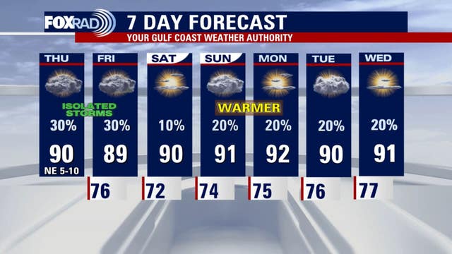
Though there is the chance of isolated storms for Thursday, coverage does not look as high as Wednesday. Temperature highs will be close to 90.
Though there is the chance of isolated storms for Thursday, coverage does not look as high as Wednesday. Temperature highs will be close to 90.

Houston weather: Isolated storms possible Thursday
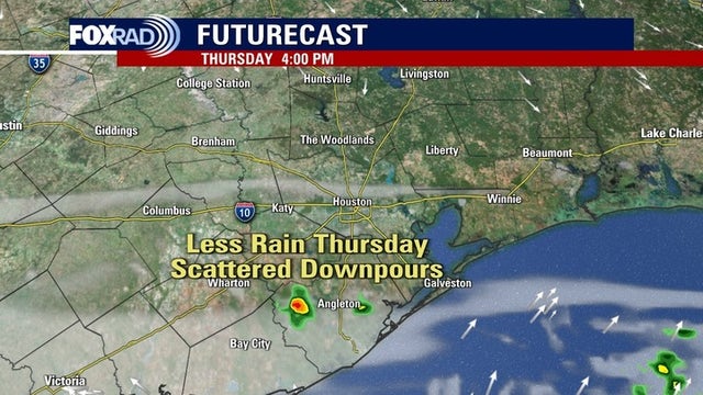
Scattered to isolated round of showers and storms are possible for Thursday, but coverage doesn?t look as high as Wednesday. However, we could still see additional rainfall as highs will stay in the 80s.
Scattered to isolated round of showers and storms are possible for Thursday, but coverage doesn?t look as high as Wednesday. However, we could still see additional rainfall as highs will stay in the 80s.

Houston weather: Isolated storms possible Thursday
A more scatted to isolated round of showers and storms are possible on Thursday. Coverage doesn?t look as high as Wednesday, but we could still see additional rainfall. Highs will stay in the 80s. This pattern will probably repeat for Friday.
A more scatted to isolated round of showers and storms are possible on Thursday. Coverage doesn?t look as high as Wednesday, but we could still see additional rainfall. Highs will stay in the 80s. This pattern will probably repeat for Friday.

Houston weather: Possible storms Wednesday night, rain continues Thursday
Look for a few downpours to be possible Wednesday evening and into the overnight hours. A more scattered to isolated round of showers and storms are possible on Thursday.
Look for a few downpours to be possible Wednesday evening and into the overnight hours. A more scattered to isolated round of showers and storms are possible on Thursday.

Houston weather: Storm chances overnight, unsettled pattern continues Thursday
Look for a few downpours to be possible Wednesday evening and into the overnight hours. A more scatted to isolated round of showers and storms are possible on Thursday.
Look for a few downpours to be possible Wednesday evening and into the overnight hours. A more scatted to isolated round of showers and storms are possible on Thursday.

Houston weather: Rain chances dropping, temps
Meteorologist John Dawson shares Houston's rain forecast for the rest of the week.
Meteorologist John Dawson shares Houston's rain forecast for the rest of the week.


Forecast: Even more deadly, fiery and uncomfortable extreme weather
A new five-year forecast warns the world is likely to keep breaking heat records, risking more wildfires, hurricanes, and deadly heat waves.
A new five-year forecast warns the world is likely to keep breaking heat records, risking more wildfires, hurricanes, and deadly heat waves.
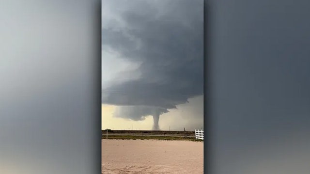

Love looms large in New Mexico as couple says 'I do' with tornado in tow
Daynnely and William Carrillo's picture-perfect wedding day in Portales was punctuated by an extraordinary backdrop: a massive, developing tornado.
Daynnely and William Carrillo's picture-perfect wedding day in Portales was punctuated by an extraordinary backdrop: a massive, developing tornado.

SpaceX launches, heat and pregnancy, and more | Forecasting with Friends
As meteorologist Allison Gargaro watches the heavy rain for May 28, we also discuss heat risks for expecting parents, the latest travel news ahead of summer break, and much more.
As meteorologist Allison Gargaro watches the heavy rain for May 28, we also discuss heat risks for expecting parents, the latest travel news ahead of summer break, and much more.

Houston weather: Showers likely for Wednesday
Over the next few days, we're looking at the potential for a lot of rain in a short amount of time. Showers and storms are likely this afternoon across Southeast Texas, making the Weather Prediction Center put our viewing area in a 2 out of 5 risk for excessive rainfall. Highs will remain in the upper-80s.
Over the next few days, we're looking at the potential for a lot of rain in a short amount of time. Showers and storms are likely this afternoon across Southeast Texas, making the Weather Prediction Center put our viewing area in a 2 out of 5 risk for excessive rainfall. Highs will remain in the upper-80s.

Houston weather: More storms possible on Wednesday
Following damaging Monday night storms, we'll transition to a mostly sunny sky with highs close to 90. As we hit those warm afternoon temps, it may ignite a few evening storms, so watch out after about 5pm. More scattered storms are likely both Wednesday and Thursday and a few could be on the strong side.
Following damaging Monday night storms, we'll transition to a mostly sunny sky with highs close to 90. As we hit those warm afternoon temps, it may ignite a few evening storms, so watch out after about 5pm. More scattered storms are likely both Wednesday and Thursday and a few could be on the strong side.

Houston weather: More storms possible this week
Following damaging Monday night storms, we'll transition to a mostly sunny sky with highs close to 90. As we hit those warm afternoon temps, it may ignite a few evening storms, so watch out after about 5pm. More scattered storms are likely both Wednesday and Thursday and a few could be on the strong side.
Following damaging Monday night storms, we'll transition to a mostly sunny sky with highs close to 90. As we hit those warm afternoon temps, it may ignite a few evening storms, so watch out after about 5pm. More scattered storms are likely both Wednesday and Thursday and a few could be on the strong side.

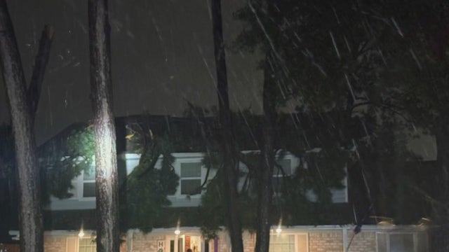
Early morning Houston storm leaves tree on top of house
A northwest Houston homeowner is speaking with us about the storms Monday night that left a tree on top of her home. Now, she says she is picking up the pieces.
A northwest Houston homeowner is speaking with us about the storms Monday night that left a tree on top of her home. Now, she says she is picking up the pieces.

2025 hurricane season approaching
Mike Iscovitz has video of the intense red dust in Australia and shares hurricane victims preparing for the upcoming season while still recovering from previous storms.
Mike Iscovitz has video of the intense red dust in Australia and shares hurricane victims preparing for the upcoming season while still recovering from previous storms.

Houston weather: Centerpoint, Entergy power outage tracker, maps
A tracker with the latest Houston power outage numbers for Centerpoint and Entergy as well as how to see the map or report an outage.
A tracker with the latest Houston power outage numbers for Centerpoint and Entergy as well as how to see the map or report an outage.
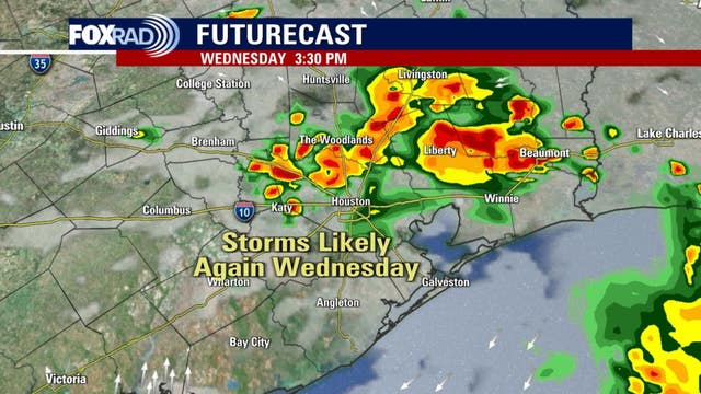

Houston weather: Storms likely again Wednesday
Tuesday brings early morning thunderstorms and then a warm afternoon with highs near 90. The unsettled pattern continues into Wednesday, with showers and thunderstorms and highs in the mid to upper 80s.
Tuesday brings early morning thunderstorms and then a warm afternoon with highs near 90. The unsettled pattern continues into Wednesday, with showers and thunderstorms and highs in the mid to upper 80s.


Deadly Katy Freeway crash: 1 killed, 1 injured after crash into tree
Authorities believe the weather was a factor in a crash that left a man dead and a woman in the hospital near Katy early Tuesday morning.
Authorities believe the weather was a factor in a crash that left a man dead and a woman in the hospital near Katy early Tuesday morning.


Houston weather: School closures, delays due for Tuesday, May 27
Strong storms moved across the Houston area on Tuesday morning, causing power outages and damage. We are keeping track of school delays and cancellations as they arise.
Strong storms moved across the Houston area on Tuesday morning, causing power outages and damage. We are keeping track of school delays and cancellations as they arise.

Houston weather forecast for May 27, 2025
Tuesday brings early morning thunderstorms and then a warm afternoon with highs near 90. The unsettled pattern continues into Wednesday, with showers and thunderstorms and highs in the mid to upper 80s. Thursday looks muggy with scattered showers and thunderstorms again. Friday and Saturday bring isolated showers and thunderstorms, with highs back to around 90.
Tuesday brings early morning thunderstorms and then a warm afternoon with highs near 90. The unsettled pattern continues into Wednesday, with showers and thunderstorms and highs in the mid to upper 80s. Thursday looks muggy with scattered showers and thunderstorms again. Friday and Saturday bring isolated showers and thunderstorms, with highs back to around 90.

Houston weather: Severe Thunderstorm Watch expires; forecast
The latest severe weather alerts, including a Severe Thunderstorm Watch, for the Houston area.
The latest severe weather alerts, including a Severe Thunderstorm Watch, for the Houston area.