

Saturday Evening Weather Update
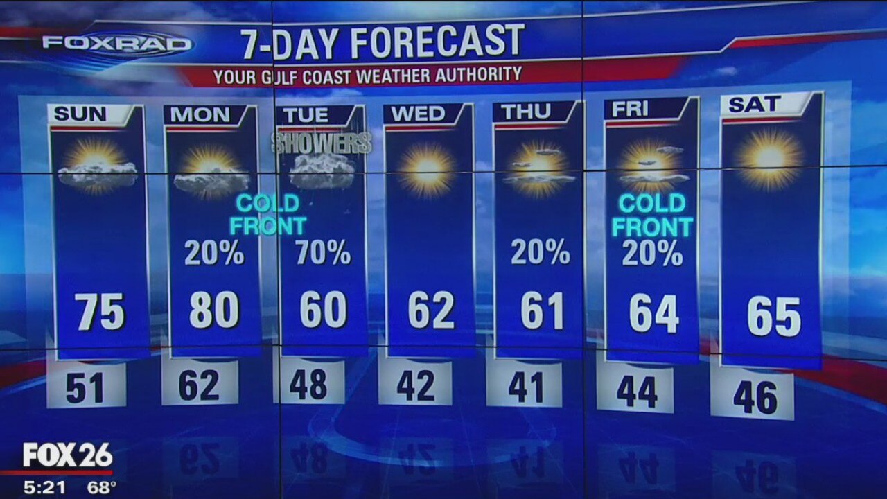
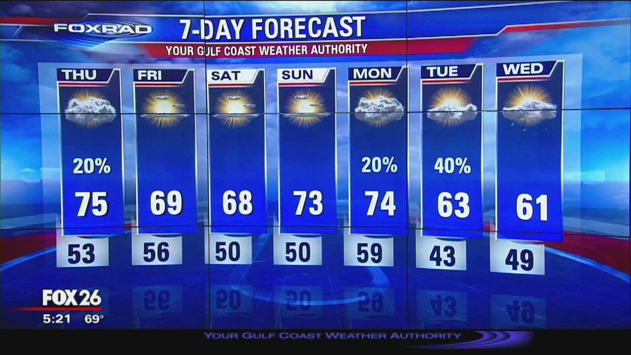
The weekend looks very nice with highs in the 60s on Sat and into the 70s by Sun. The next front will arrive early on Tue and there will be a little better chance for some rain with this one.
The weekend looks very nice with highs in the 60s on Sat and into the 70s by Sun. The next front will arrive early on Tue and there will be a little better chance for some rain with this one.
FoxRad Forecast 12/7
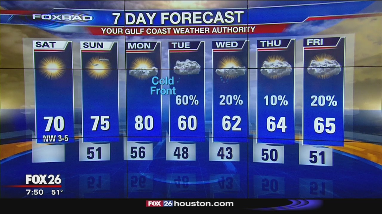
The weekend is here and so are those clear, blue skies with plenty of sun. Highs will near 70 on Saturday and warm into the mid 70s by Sunday. Next cold front arrives Tuesday.
The weekend is here and so are those clear, blue skies with plenty of sun. Highs will near 70 on Saturday and warm into the mid 70s by Sunday. Next cold front arrives Tuesday.
Friday Night Weather Update
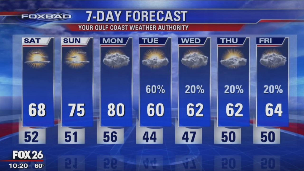
The next front will arrive early on Tue and there will be a little better chance for some rain with this one.
The next front will arrive early on Tue and there will be a little better chance for some rain with this one.
Friday Evening Weather Update
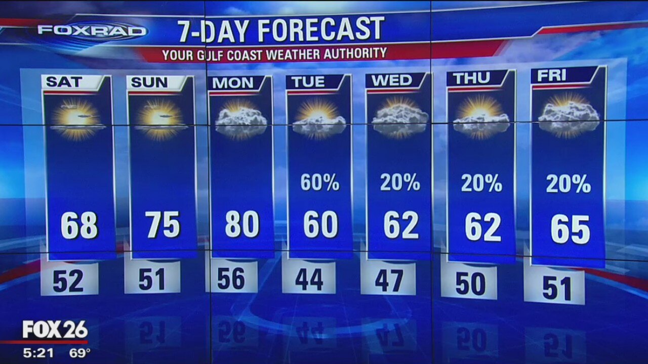
The weekend looks very nice with highs in the 60s on Sat and into the 70s by Sun. The next front will arrive early on Tue and there will be a little better chance for some rain with this one.
The weekend looks very nice with highs in the 60s on Sat and into the 70s by Sun. The next front will arrive early on Tue and there will be a little better chance for some rain with this one.
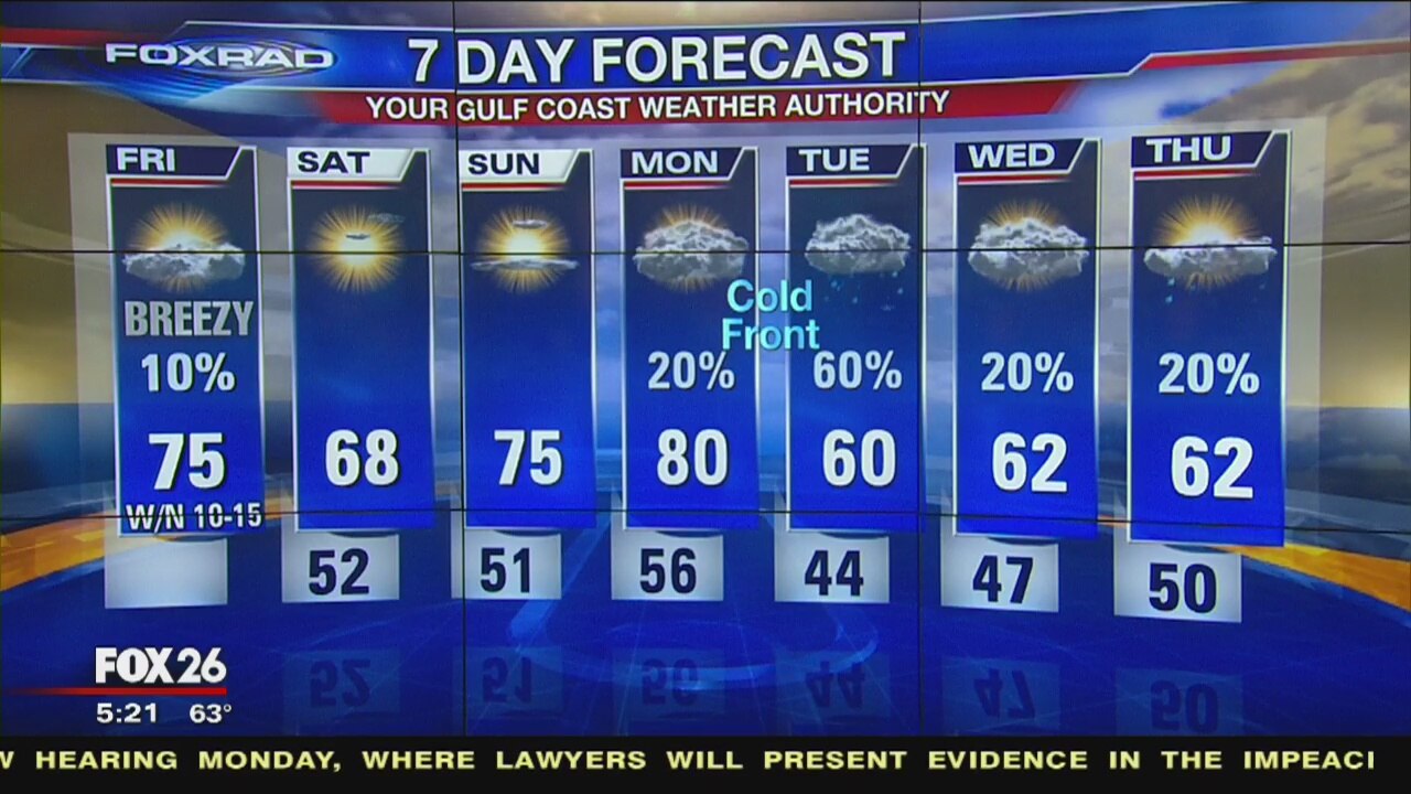
Friday morning weather forecast
We're seeing patches of dense fog this morning, but that will lift later this morning. A weak cold front will push through the area today, shifting winds but not affecting temperatures all that much. We'll still warm into the low and mid 70s. This evening, under clearing skies, we will dip into the low 50s. Saturday and Sunday are still looking very nice with highs in the upper 60s and low 70s and lows near 50. Our next shot of rain comes late Monday into Tuesday with a stronger cold front that will move through.
We're seeing patches of dense fog this morning, but that will lift later this morning. A weak cold front will push through the area today, shifting winds but not affecting temperatures all that much. We'll still warm into the low and mid 70s. This evening, under clearing skies, we will dip into the low 50s. Saturday and Sunday are still looking very nice with highs in the upper 60s and low 70s and lows near 50. Our next shot of rain comes late Monday into Tuesday with a stronger cold front that will move through.
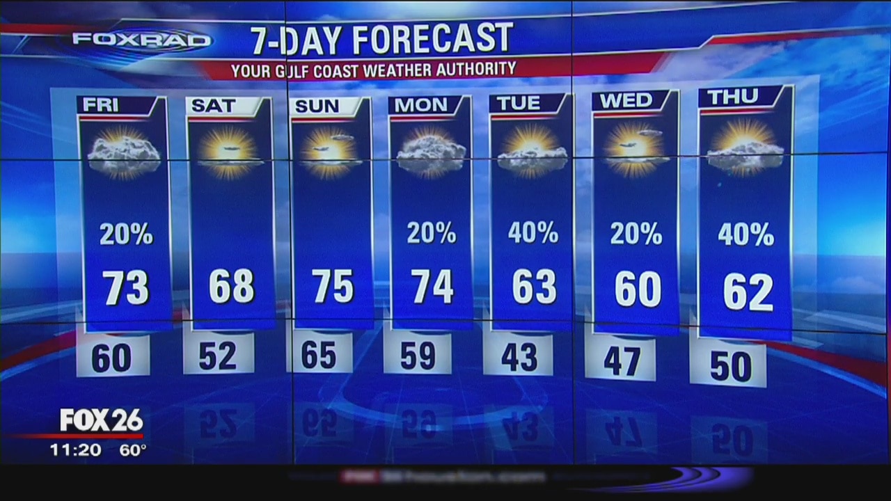
Gulf Coast Weather Authority Forecast with Dr. Jim Siebert
A Pacific cold front will arrive in SE Texas early on Friday and it will cool things down a little. Highs will still be in the upper 60s on Saturday and into the middle 70s by Sunday. The next front will arrive on Tuesday.
A Pacific cold front will arrive in SE Texas early on Friday and it will cool things down a little. Highs will still be in the upper 60s on Saturday and into the middle 70s by Sunday. The next front will arrive on Tuesday.
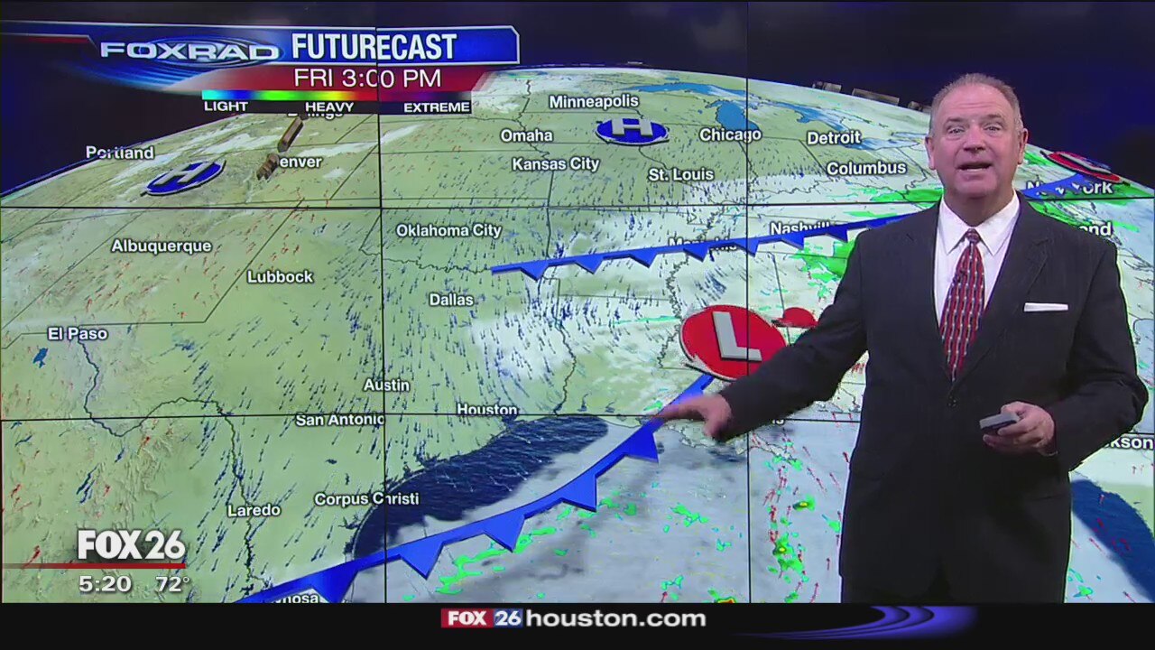
Thursday Evening Weather Forecast
FOX 26 Meteorologist Dr. Jim Siebert gives you a look at what to expect this evening!
FOX 26 Meteorologist Dr. Jim Siebert gives you a look at what to expect this evening!
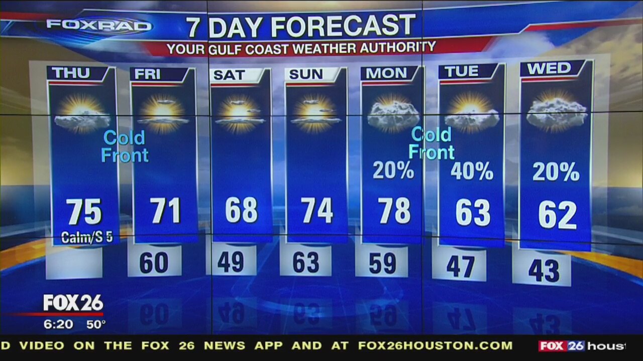
Thursday morning weather forecast
Temperatures will warm into the mid 70s once again on Thursday with a few more clouds. Our first of two cold fronts is still on track to arrive during the morning on Friday, but it does look like the front won't bring any rain to the area. The weekend is looking sunny and dry with temperatures slightly cooler on Saturday. Our next, stronger cold front will arrive Monday night into Tuesday and rain chances will be slightly higher for Tuesday.
Temperatures will warm into the mid 70s once again on Thursday with a few more clouds. Our first of two cold fronts is still on track to arrive during the morning on Friday, but it does look like the front won't bring any rain to the area. The weekend is looking sunny and dry with temperatures slightly cooler on Saturday. Our next, stronger cold front will arrive Monday night into Tuesday and rain chances will be slightly higher for Tuesday.

Wednesday Night Weather Update
Thursday will be a little warmer and we can expect a few more clouds. A front will arrive by Friday morning, but rain chances will be slim and the temps will only cool a little. The weekend is still looking very nice.
Thursday will be a little warmer and we can expect a few more clouds. A front will arrive by Friday morning, but rain chances will be slim and the temps will only cool a little. The weekend is still looking very nice.
Wednesday Evening Weather Update
Thursday will be a little warmer and we can expect a few more clouds. A front will arrive by Friday morning, but rain chances will be slim and the temps will only cool a little. The weekend is still looking very nice.
Thursday will be a little warmer and we can expect a few more clouds. A front will arrive by Friday morning, but rain chances will be slim and the temps will only cool a little. The weekend is still looking very nice.
Wednesday afternoon weather forecast
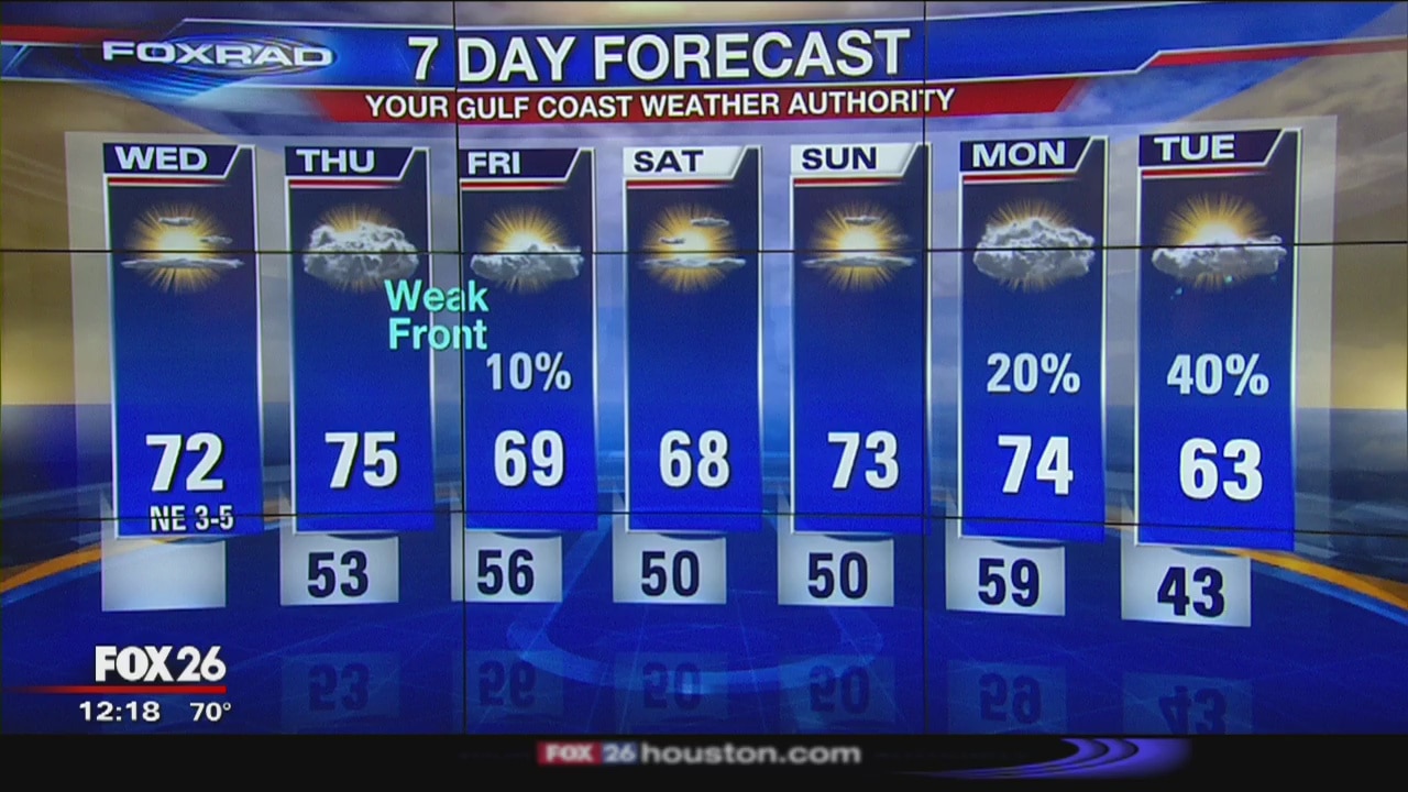
Dry and sunny conditions continue for southeast Texas. Temperatures on Wednesday and Thursday will warm into the low 70s ahead of our next weak front which will push through late Thursday. While we can't rule out a sprinkle on Friday, it's looking like a dry front. The weekend will be seasonable with highs reaching the upper 60s and lows in the low 50s and upper 40s. Next strong cold front will arrive Monday into Tuesday.
Dry and sunny conditions continue for southeast Texas. Temperatures on Wednesday and Thursday will warm into the low 70s ahead of our next weak front which will push through late Thursday. While we can't rule out a sprinkle on Friday, it's looking like a dry front. The weekend will be seasonable with highs reaching the upper 60s and lows in the low 50s and upper 40s. Next strong cold front will arrive Monday into Tuesday.

Wednesday morning weather forecast
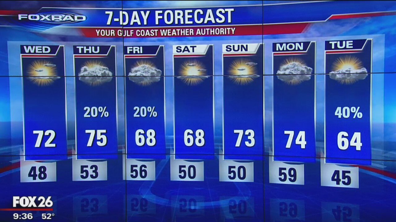
Dry and sunny conditions continue for southeast Texas. Temperatures on Wednesday and Thursday will warm into the low 70s ahead of our next weak front which will push through late Thursday. While we can't rule out a sprinkle on Friday, it's looking like a dry front. The weekend will be seasonable with highs reaching the upper 60s and lows in the low 50s and upper 40s. The next strong cold front will arrive Monday into Tuesday.
Dry and sunny conditions continue for southeast Texas. Temperatures on Wednesday and Thursday will warm into the low 70s ahead of our next weak front which will push through late Thursday. While we can't rule out a sprinkle on Friday, it's looking like a dry front. The weekend will be seasonable with highs reaching the upper 60s and lows in the low 50s and upper 40s. The next strong cold front will arrive Monday into Tuesday.
Tuesday Night Weather Update
Our forecast is looking great for the next several days. Sunshine and dry air will remain in place for the most part with one short-lived chance for rain along a weak front late Thursday night. Otherwise, temperatures will stay seasonable with lows in the 40s and 50s and daily highs near 70.
Our forecast is looking great for the next several days. Sunshine and dry air will remain in place for the most part with one short-lived chance for rain along a weak front late Thursday night. Otherwise, temperatures will stay seasonable with lows in the 40s and 50s and daily highs near 70.

Tuesday Evening Weather Update
Our forecast is looking great for the next several days. Sunshine and dry air will remain in place for the most part with one short-lived chance for rain along a weak front late Thursday night. Otherwise, temperatures will stay seasonable with lows in the 40s and 50s and daily highs near 70.
Our forecast is looking great for the next several days. Sunshine and dry air will remain in place for the most part with one short-lived chance for rain along a weak front late Thursday night. Otherwise, temperatures will stay seasonable with lows in the 40s and 50s and daily highs near 70.
Tuesday morning weather forecast
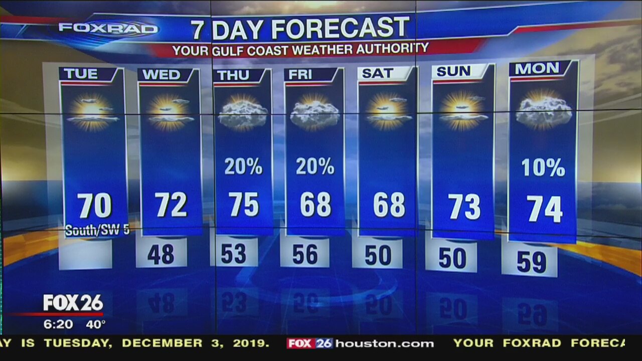
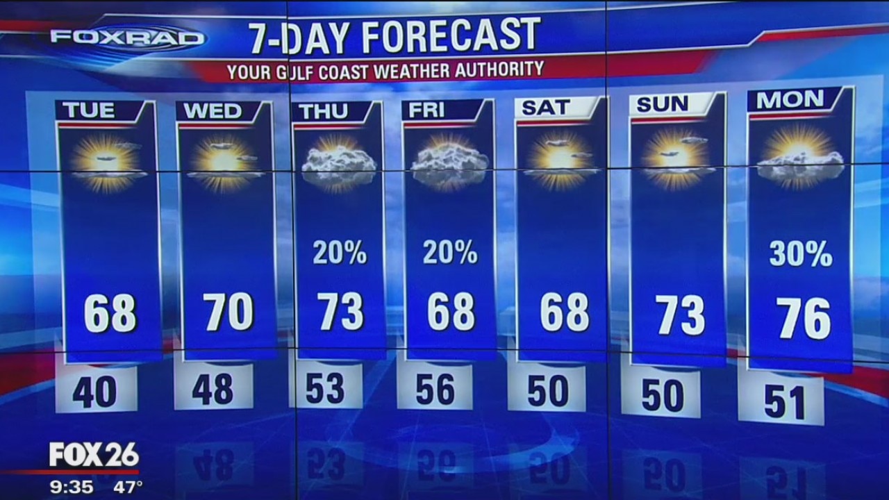
Clear and cold this morning with many areas in the upper 30s, then sunny and dry with highs close to 70.
Clear and cold this morning with many areas in the upper 30s, then sunny and dry with highs close to 70.
Monday Night Weather Update
It will be chilly in the mornings through the middle of the week, but the afternoons will be rather nice with highs back into the 70s by Wednesday.
It will be chilly in the mornings through the middle of the week, but the afternoons will be rather nice with highs back into the 70s by Wednesday.

Monday Evening Weather Update
It will be chilly in the mornings through the middle of the week, but the afternoons will be rather nice with highs back into the 70s by Wednesday. The next better chance for rain doesn't come until next week.
It will be chilly in the mornings through the middle of the week, but the afternoons will be rather nice with highs back into the 70s by Wednesday. The next better chance for rain doesn't come until next week.
Monday morning weather forecast
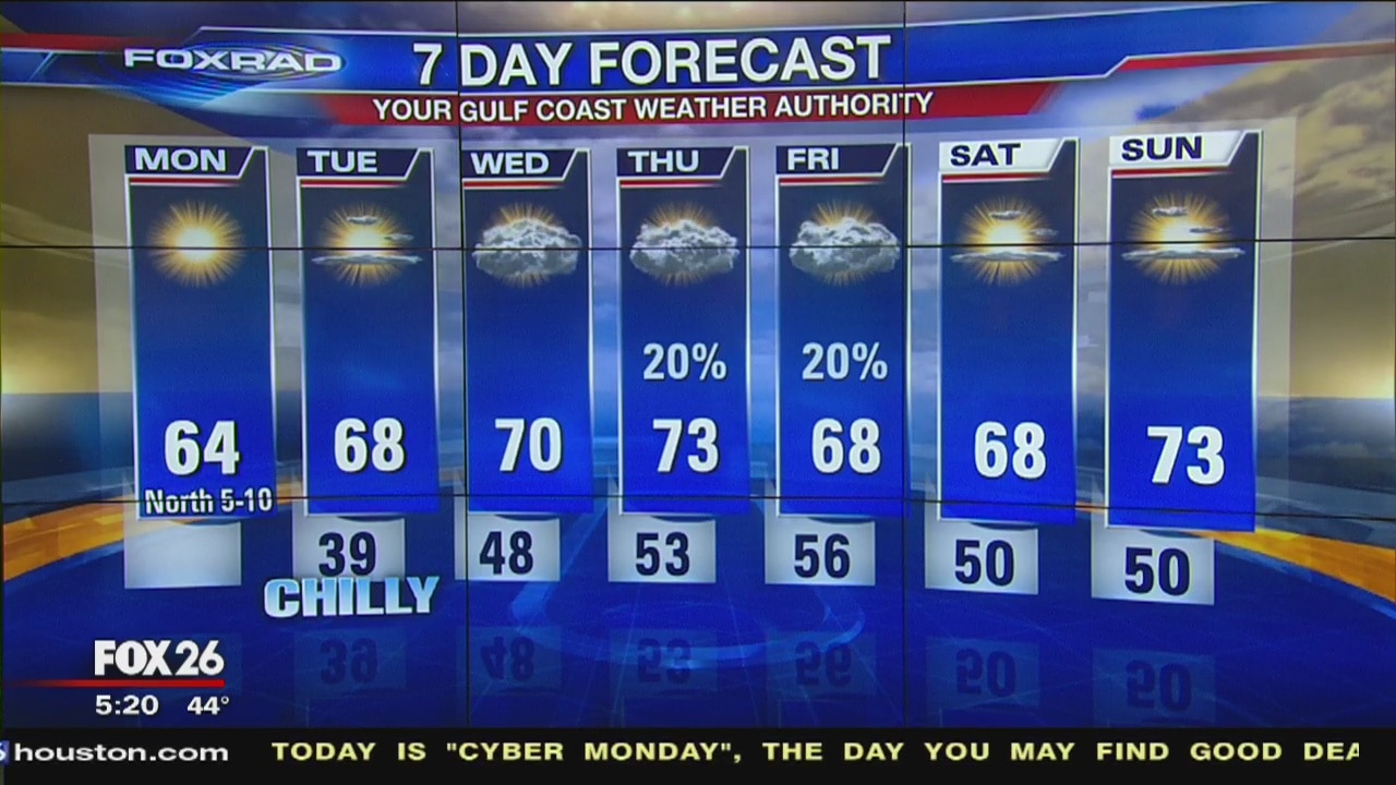
Clear and cold this morning, then sunny, cool and dry with highs in the low to mid 60s.
Clear and cold this morning, then sunny, cool and dry with highs in the low to mid 60s.
Evening Weather Forecast with Meteorologist John Dawson
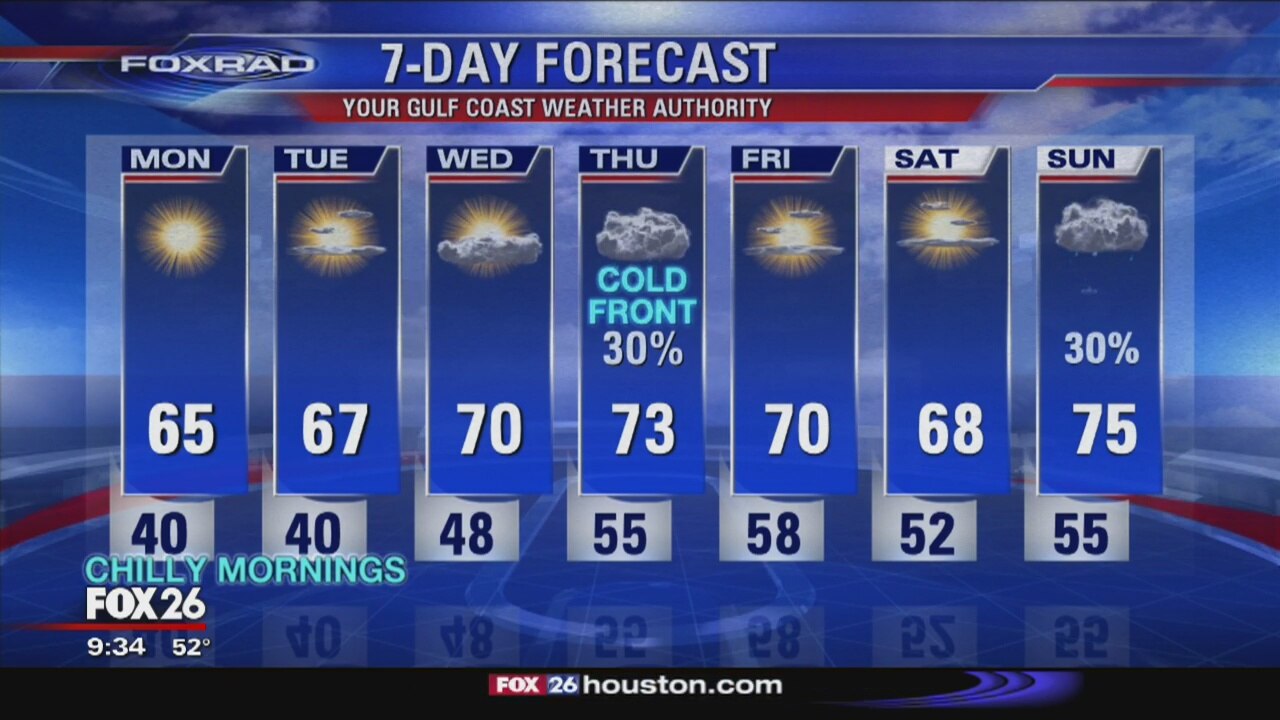
The weather will be excellent this week, and there will be a mild front on Tuesday.
The weather will be excellent this week, and there will be a mild front on Tuesday.
Your 5 p.m. Gulf Coast Weather Forecast
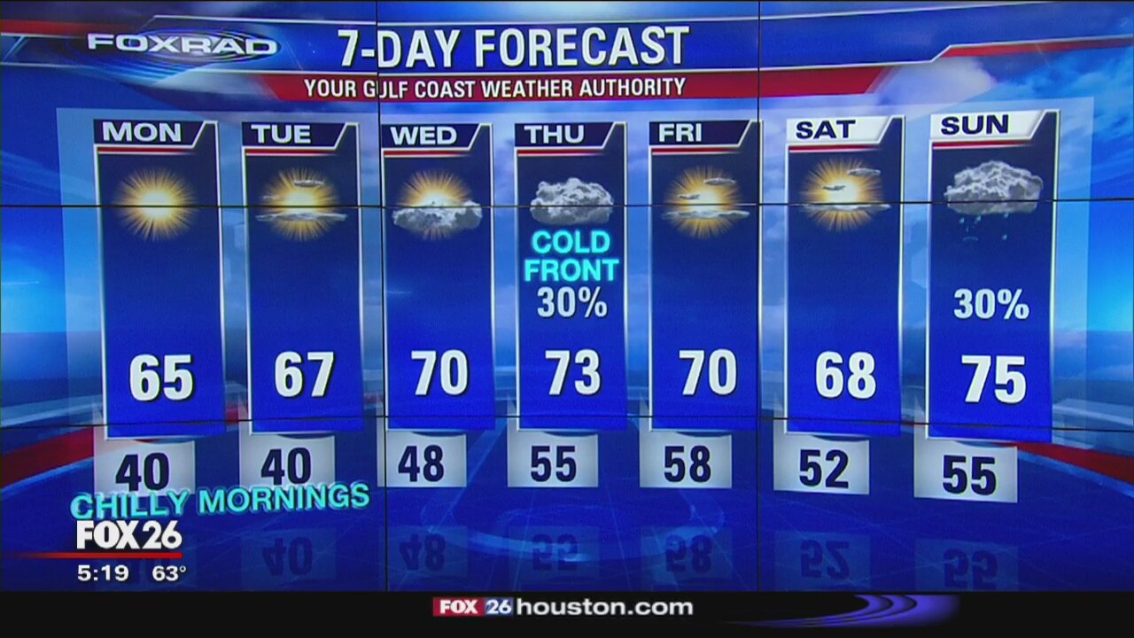
Cool air will move in for Sunday through much of next week.
Cool air will move in for Sunday through much of next week.