


Friday Night Weather Update
Heading into this weekend we?ll see sunshine, but the mornings will still be chilly - getting down into the low 40s and possibly some upper 30s with high temperatures in the 60s on Saturday and low 70s on Super Bowl Sunday.
Heading into this weekend we?ll see sunshine, but the mornings will still be chilly - getting down into the low 40s and possibly some upper 30s with high temperatures in the 60s on Saturday and low 70s on Super Bowl Sunday.

Weekend Weather Forecast
Your Gulf Coast Authority Chief Meteorologist Dr. Jim Seibert gives you a look at what to expect this weekend.
Your Gulf Coast Authority Chief Meteorologist Dr. Jim Seibert gives you a look at what to expect this weekend.
Friday morning weather forecast
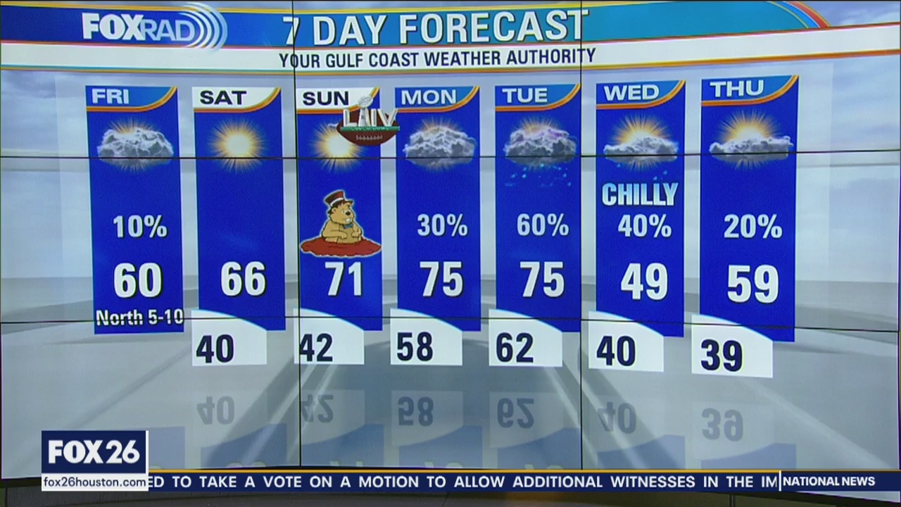
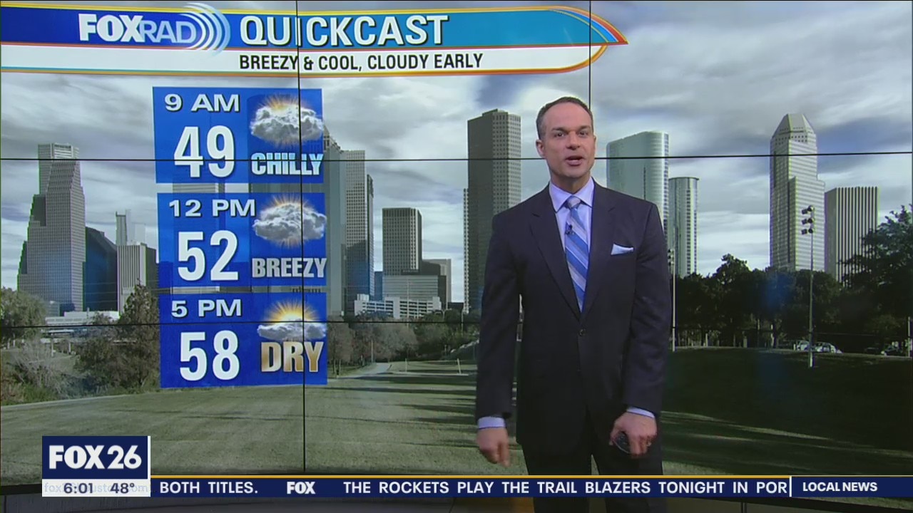
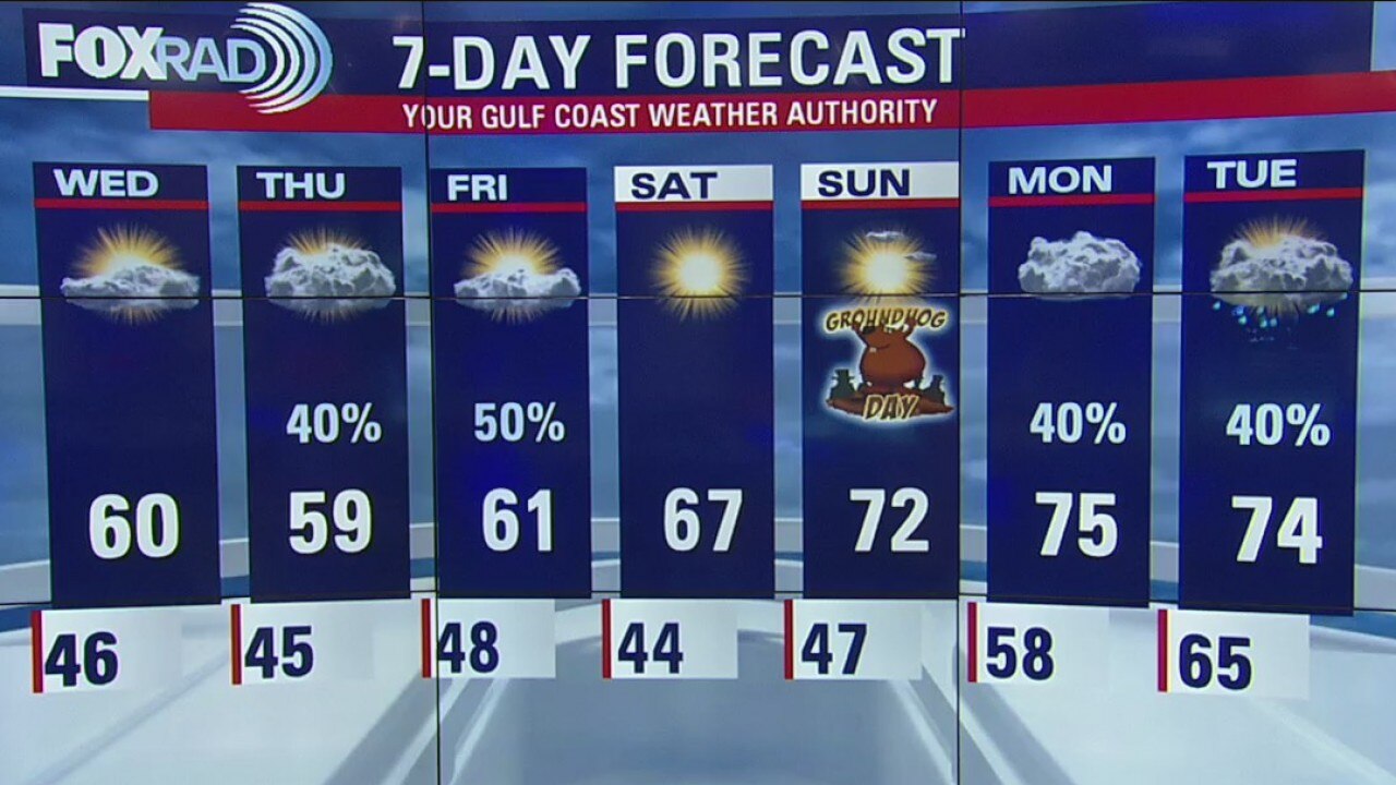
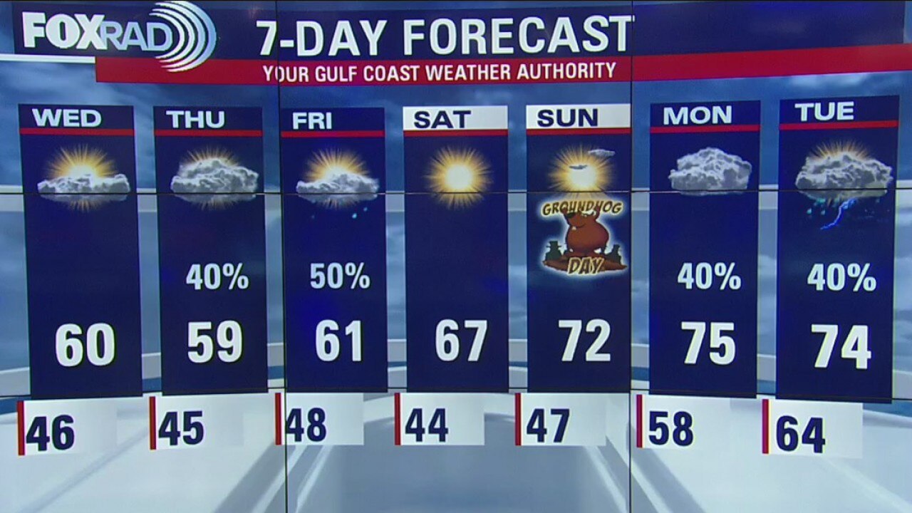
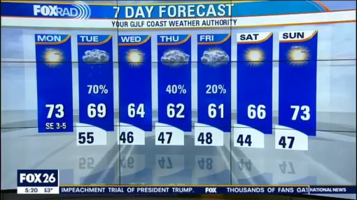
The cloudy sky today will likely keep our temperatures in the 50s in most locations. Heading into this weekend we?ll see sunshine, but the mornings will still be chilly - getting down into the low 40s and possibly some upper 30s with high temperatures in the 60s on Saturday and low 70s on Super Bowl Sunday. Sunday is also Groundhog Day, don?t forget. Next week, there may be a strong cold front late Tuesday into early Wednesday, so we?ll watch that.
The cloudy sky today will likely keep our temperatures in the 50s in most locations. Heading into this weekend we?ll see sunshine, but the mornings will still be chilly - getting down into the low 40s and possibly some upper 30s with high temperatures in the 60s on Saturday and low 70s on Super Bowl Sunday. Sunday is also Groundhog Day, don?t forget. Next week, there may be a strong cold front late Tuesday into early Wednesday, so we?ll watch that.

Thursday Night Weather Update
Mornings will be chilly, but afternoons should be pleasant. We are in for a beautiful Super Bowl weekend.
Mornings will be chilly, but afternoons should be pleasant. We are in for a beautiful Super Bowl weekend.

Thursday Evening Weather Update
After a chance for morning showers on Friday, dry and cool air will move in and leave behind a clear weekend.
After a chance for morning showers on Friday, dry and cool air will move in and leave behind a clear weekend.
Thursday afternoon weather forecast
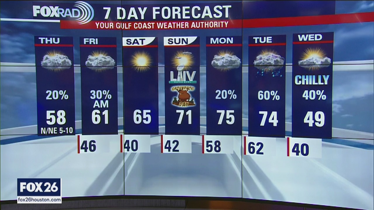
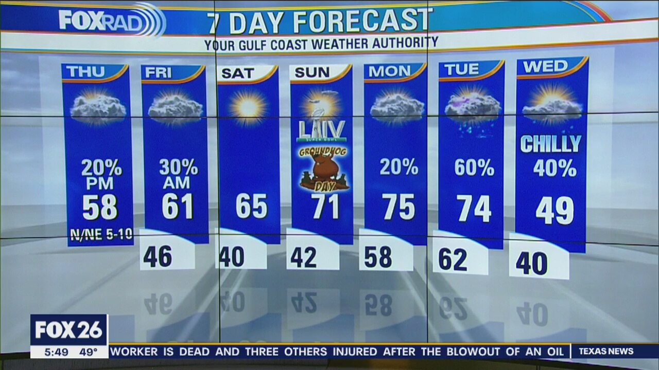
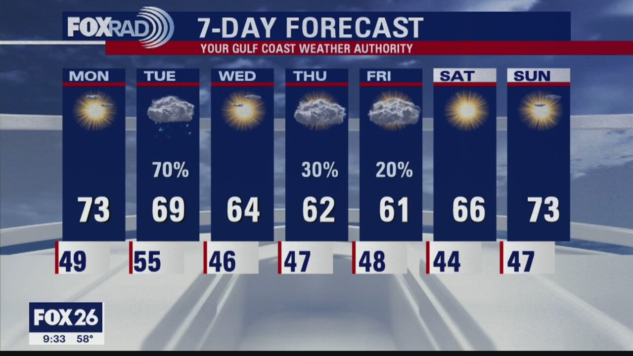
Mostly cloudy and cool conditions will hang around once again today. Watch for isolated areas of light rain today with a higher chance for brief downpours overnight. After a chance for morning showers on Friday, dry and cool air will move in and leave behind a clear weekend. Mornings will be chilly, but afternoons should be pleasant.
Mostly cloudy and cool conditions will hang around once again today. Watch for isolated areas of light rain today with a higher chance for brief downpours overnight. After a chance for morning showers on Friday, dry and cool air will move in and leave behind a clear weekend. Mornings will be chilly, but afternoons should be pleasant.
Thursday morning weather forecast
Mostly cloudy and cool conditions will hang around once again today. Watch for isolated areas of light rain today with a higher chance for brief downpours overnight. After a chance for morning showers on Friday, dry and cool air will move in and leave behind a clear weekend. Mornings will be chilly, but afternoons should be pleasant.
Mostly cloudy and cool conditions will hang around once again today. Watch for isolated areas of light rain today with a higher chance for brief downpours overnight. After a chance for morning showers on Friday, dry and cool air will move in and leave behind a clear weekend. Mornings will be chilly, but afternoons should be pleasant.

Wednesday Night Weather Update
The upcoming Super Bowl weekend is looking great with cool mornings and pleasant days. Next week, expect rain on Monday and Tuesday with a stronger cold front possible by Wednesday.
The upcoming Super Bowl weekend is looking great with cool mornings and pleasant days. Next week, expect rain on Monday and Tuesday with a stronger cold front possible by Wednesday.
Wednesday Evening Weather Update
The last few days of January will bring seasonably cool air along with a brief chance for rain late Thursday into early Friday.
The last few days of January will bring seasonably cool air along with a brief chance for rain late Thursday into early Friday.
Wednesday morning weather forecast
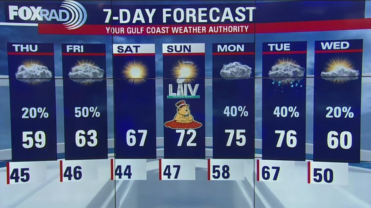
The last few days of January will bring seasonably cool air along with a brief chance for rain late Thursday into early Friday. The upcoming Super Bowl weekend is looking great with cool mornings and pleasant days. Next week, expect rain on Monday and Tuesday with a stronger cold front possible by Wednesday.
The last few days of January will bring seasonably cool air along with a brief chance for rain late Thursday into early Friday. The upcoming Super Bowl weekend is looking great with cool mornings and pleasant days. Next week, expect rain on Monday and Tuesday with a stronger cold front possible by Wednesday.
Tuesday Night Weather Update
Wednesday will have much less rain, but there will still be a lot of cloud cover. The temps will also be cooler in the morning. More showers are expected late Thursday into early Friday but the weekend is looking rather sunny.
Wednesday will have much less rain, but there will still be a lot of cloud cover. The temps will also be cooler in the morning. More showers are expected late Thursday into early Friday but the weekend is looking rather sunny.
Tuesday Evening Weather Update
We?ll stay on the cool side through the end of the week with showers returning Thursday night into Friday morning.
We?ll stay on the cool side through the end of the week with showers returning Thursday night into Friday morning.

Tuesday morning weather forecast
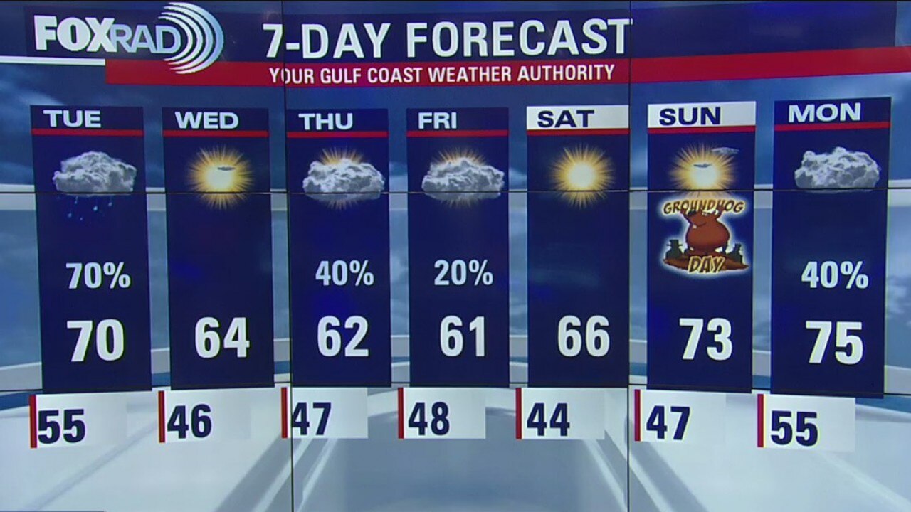
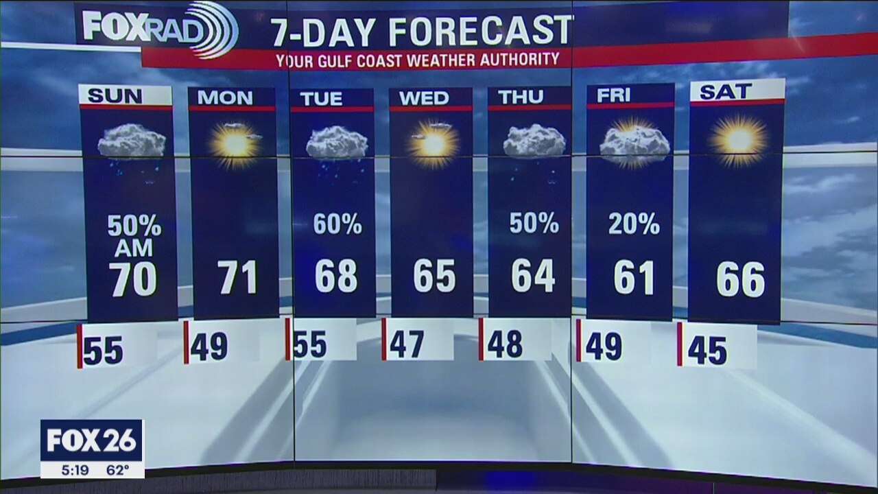
A quick-moving round of showers and storms will keep our Tuesday pretty soggy, but cool and dry air will follow it. Watch for around 1-1.5? of rain today with highs in the upper 60s followed by clearing skies and a low Wednesday morning in the 40s. We?ll stay on the cool side through the end of the week with showers returning Thursday night into Friday morning.
A quick-moving round of showers and storms will keep our Tuesday pretty soggy, but cool and dry air will follow it. Watch for around 1-1.5? of rain today with highs in the upper 60s followed by clearing skies and a low Wednesday morning in the 40s. We?ll stay on the cool side through the end of the week with showers returning Thursday night into Friday morning.
Monday Night Weather Update
The rest of the week looks quiet except for a few rain showers on Thursday.
The rest of the week looks quiet except for a few rain showers on Thursday.

Monday Evening Weather Update
A front will arrive on Tuesday and bring some showers into southeast Texas. We may get a little bit of thunder, but big weather is not expected.
A front will arrive on Tuesday and bring some showers into southeast Texas. We may get a little bit of thunder, but big weather is not expected.

Monday morning weather forecast
Dense Fog Advisory is in effect for the entire viewing area until 10AM Monday. We should see conditions improve by the afternoon with the sun shining later, too. Temperatures should warm into the upper 60s and low 70s. Clouds will increase Monday night into Tuesday with rain looking likely. It will be a quick moving system, similar to Sunday's rain. High temperatures will be knocked back a bit, reaching only the 60s with lows in the 40s.
Dense Fog Advisory is in effect for the entire viewing area until 10AM Monday. We should see conditions improve by the afternoon with the sun shining later, too. Temperatures should warm into the upper 60s and low 70s. Clouds will increase Monday night into Tuesday with rain looking likely. It will be a quick moving system, similar to Sunday's rain. High temperatures will be knocked back a bit, reaching only the 60s with lows in the 40s.
Your Gulf Coat Weather Forecast with Meteorologist John Dawson
Here is your evening weather forecast with Meteorologist John Dawson
Here is your evening weather forecast with Meteorologist John Dawson
Your Gulf Coast Weather Update with Meteorologist John Dawson
Showers are expected to roll back in late Saturday through the day on Sunday.?
Showers are expected to roll back in late Saturday through the day on Sunday.?
Fox 26 Morning News Weekends 7:00 a.m.
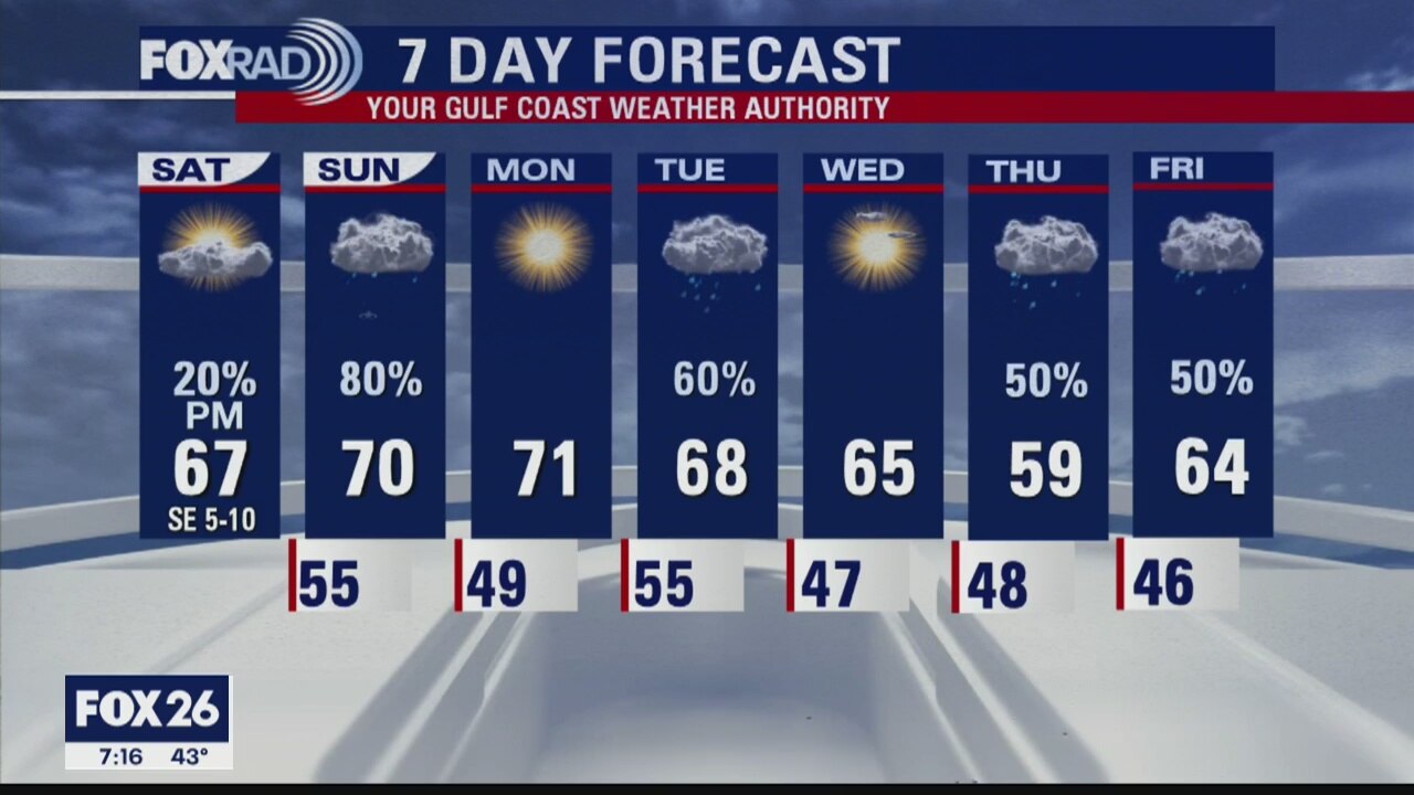
Expect a mostly sunny to partly cloudy Saturday with temperatures warming into the upper 60s once again. Rain chances increase after midnight with pockets of heavy rain possible before it exits by Sunday afternoon.
Expect a mostly sunny to partly cloudy Saturday with temperatures warming into the upper 60s once again. Rain chances increase after midnight with pockets of heavy rain possible before it exits by Sunday afternoon.