

Wednesday Evening Weather Forecast
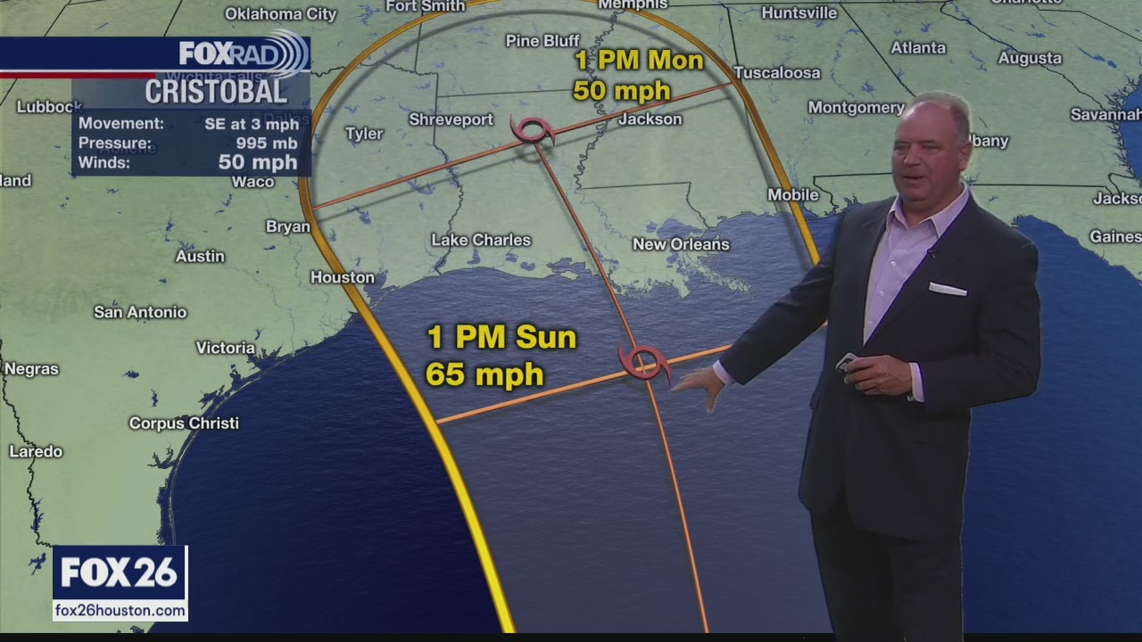
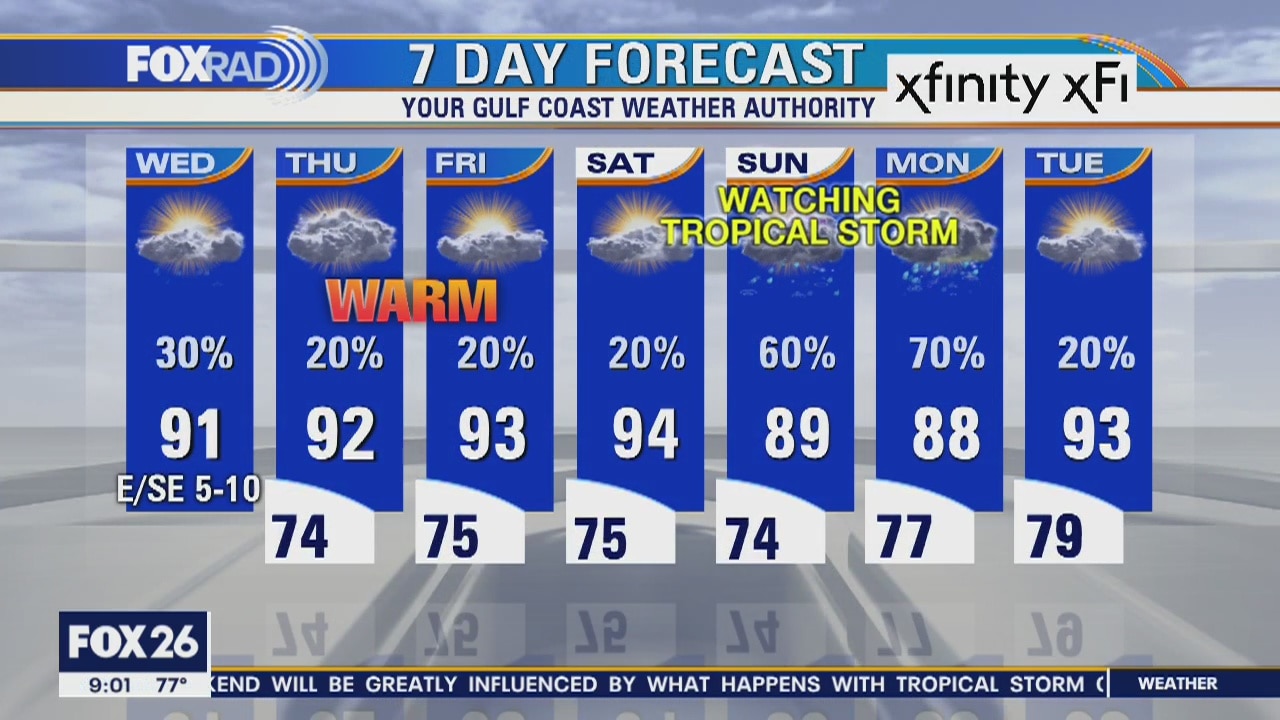
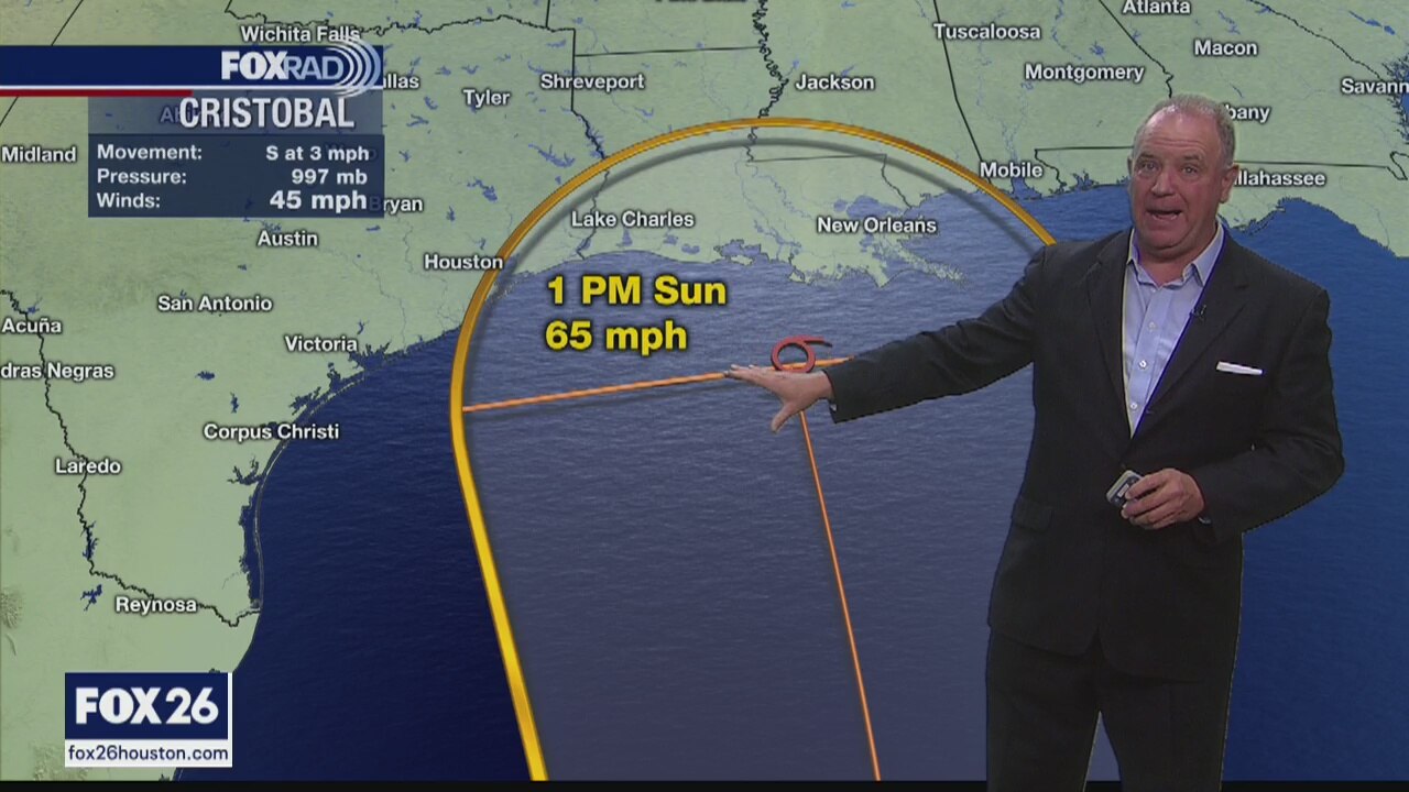
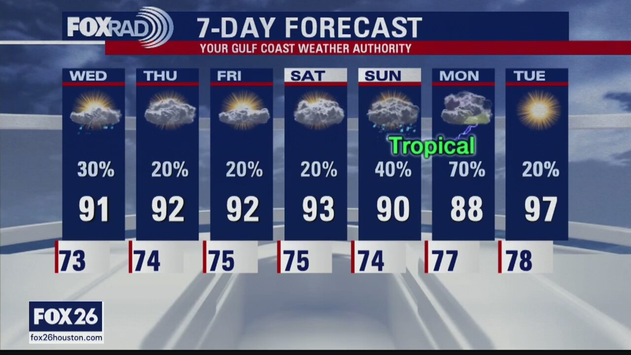
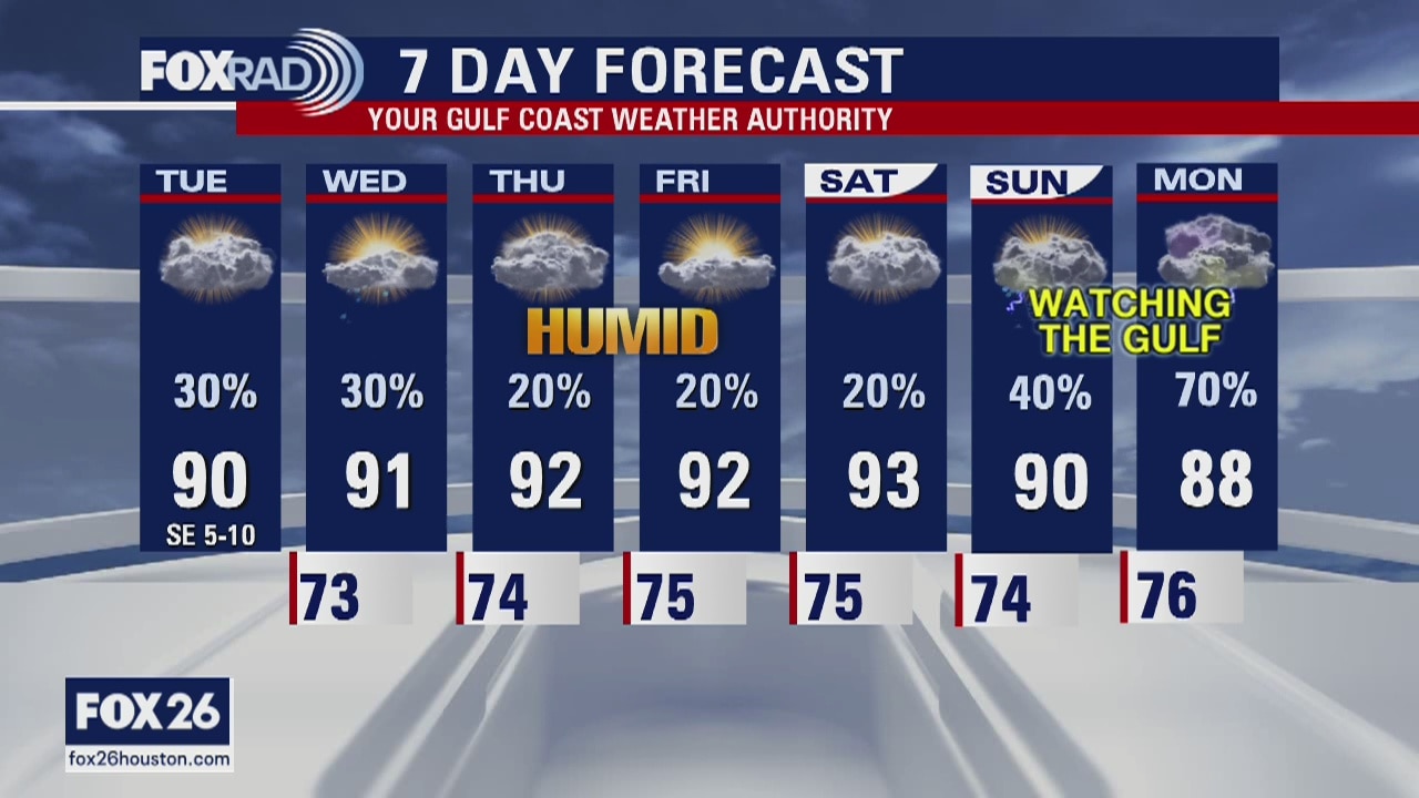
The next few days will continue to be very warm and humid. There will be some pop-up afternoon showers and rain chances will rise by Sunday depending on what happens with Cristobal. It's looking better for SE Texas as Louisiana appears to be the most likely landfall, but too early to call it.
The next few days will continue to be very warm and humid. There will be some pop-up afternoon showers and rain chances will rise by Sunday depending on what happens with Cristobal. It's looking better for SE Texas as Louisiana appears to be the most likely landfall, but too early to call it.
Wednesday weather forecasts
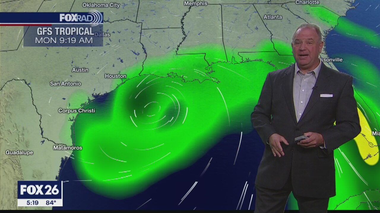
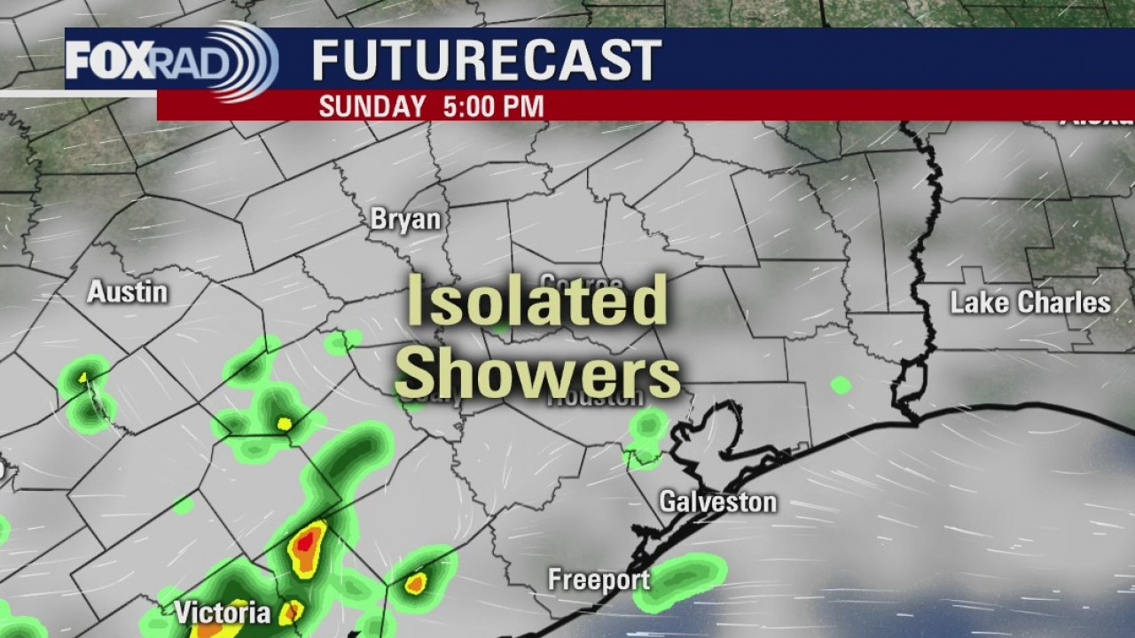
As we continue to monitor the path of Tropical Storm Cristobal in the far southern Gulf of Mexico, our local forecast will be hit and humid. Watch for widely scattered afternoon storms today and a slight chance Thursday. Afternoon heat index values could climb to 100 degrees. The tropical storm is still expected to move toward the northern Gulf Coast by Monday, but with lots of uncertainty, be sure to check back for updates.
As we continue to monitor the path of Tropical Storm Cristobal in the far southern Gulf of Mexico, our local forecast will be hit and humid. Watch for widely scattered afternoon storms today and a slight chance Thursday. Afternoon heat index values could climb to 100 degrees. The tropical storm is still expected to move toward the northern Gulf Coast by Monday, but with lots of uncertainty, be sure to check back for updates.
A look at the tropics and futurecast
The next couple of days look warm alone with a few pop-up showers. The end of the weekend will be greatly influenced by what happens with Cristobal in the Gulf. One thing we count on is a better chance for rain Sunday night and Monday.
The next couple of days look warm alone with a few pop-up showers. The end of the weekend will be greatly influenced by what happens with Cristobal in the Gulf. One thing we count on is a better chance for rain Sunday night and Monday.
TS Cristobal and the Houston area forecast
TS Cristobal and the Houston area forecast
TS Cristobal and the Houston area forecast
Tuesday weather forecast
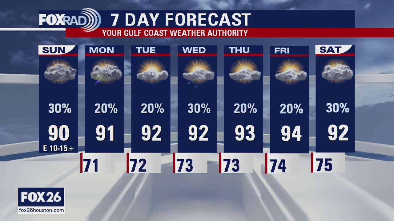
All eyes will be on the developing tropical system in the far southern Gulf of Mexico, but over the next few days, or weather will be very typical of early June: warm and humid with isolated showers and storms. Look for highs in the low 90s with a few afternoon showers each day. The eventual path of Tropical Storm Cristobal will be slow, but could affect anywhere along the northern Gulf Coast early next week.
All eyes will be on the developing tropical system in the far southern Gulf of Mexico, but over the next few days, or weather will be very typical of early June: warm and humid with isolated showers and storms. Look for highs in the low 90s with a few afternoon showers each day. The eventual path of Tropical Storm Cristobal will be slow, but could affect anywhere along the northern Gulf Coast early next week.


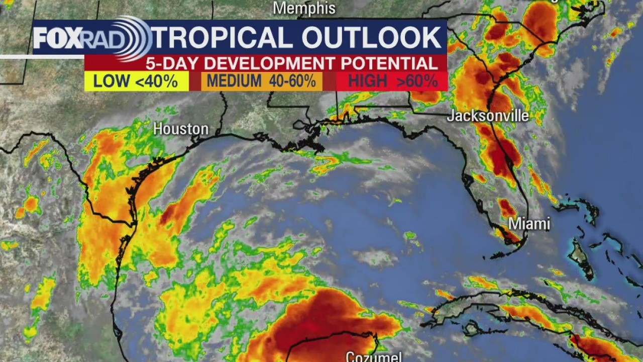
Depression forms in Gulf, heavy rain threat for south Mexico
A tropical depression that formed Monday in the Gulf of Mexico is forecast to become a tropical storm in coming hours, with heavy rains already causing deadly flash flooding in parts of southern Mexico and Central America.
A tropical depression that formed Monday in the Gulf of Mexico is forecast to become a tropical storm in coming hours, with heavy rains already causing deadly flash flooding in parts of southern Mexico and Central America.
Monday evening forecast
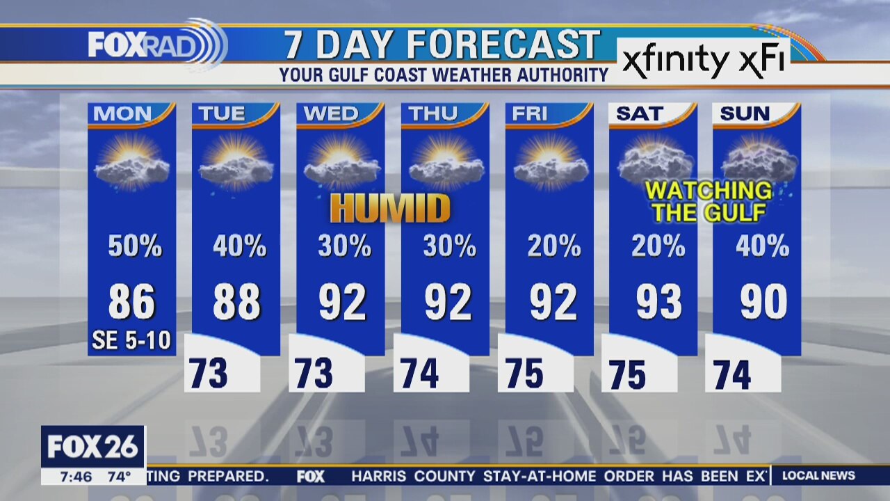
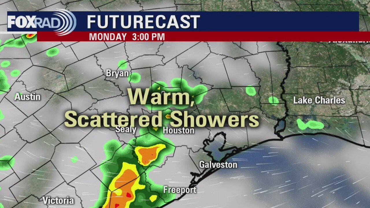
The forecast calls for less rain, but not fully rain-free. Next week all depends on what happens with the low expected to develop in the southern Gulf and then move northward. It could be close by on Monday or so. It's too early to know.
The forecast calls for less rain, but not fully rain-free. Next week all depends on what happens with the low expected to develop in the southern Gulf and then move northward. It could be close by on Monday or so. It's too early to know.
Monday weather forecast
Much of our focus this week will be on a developing tropical system in the southern Gulf of Mexico. This is an area of low pressure that was tropical storm Amanda in the Pacific Ocean and has crossed Central America. It may play a role in our forecast by this weekend. In the mean time, look for scattered storms today, then isolated storms for the rest of the week with highs in the low 90s by Wednesday.
Much of our focus this week will be on a developing tropical system in the southern Gulf of Mexico. This is an area of low pressure that was tropical storm Amanda in the Pacific Ocean and has crossed Central America. It may play a role in our forecast by this weekend. In the mean time, look for scattered storms today, then isolated storms for the rest of the week with highs in the low 90s by Wednesday.
Monday Morning Weather Forecast
Your Gulf Coast Weather Authority Meteorologist John Dawson looks ahead to showers expected to move through the area Monday afternoon.
Your Gulf Coast Weather Authority Meteorologist John Dawson looks ahead to showers expected to move through the area Monday afternoon.
Houston area weather forecast 5/31
A few showers close to the coast this Sunday morning and as we work our way through the day, a few more showers and storms will possibly develop. We will remain warm this week as we watch an area in the Bay of Campeche for possible tropical development.
A few showers close to the coast this Sunday morning and as we work our way through the day, a few more showers and storms will possibly develop. We will remain warm this week as we watch an area in the Bay of Campeche for possible tropical development.
Sunday Morning Weather Forecast
Your Gulf Coast Weather Authority Meteorologist John Dawson gives you a look at possible showers headed our way Sunday afternoon.
Your Gulf Coast Weather Authority Meteorologist John Dawson gives you a look at possible showers headed our way Sunday afternoon.

Houston area weather forecast 5/30
The weekend is starting off quiet with more clouds than sun. Expect peeks of sun throughout the day and afternoon rain chances, especially a little closer to the coast. Chances will remain slim for storms, but the can't be totally ruled out Saturday and Sunday. Highs both days will reach the low 90s.
The weekend is starting off quiet with more clouds than sun. Expect peeks of sun throughout the day and afternoon rain chances, especially a little closer to the coast. Chances will remain slim for storms, but the can't be totally ruled out Saturday and Sunday. Highs both days will reach the low 90s.
Saturday Weather Forecast
Meteorologist John Dawson gives you a look at this weekend's weather. He also looks at weather in the area of tomorrow's Space X launch.
Meteorologist John Dawson gives you a look at this weekend's weather. He also looks at weather in the area of tomorrow's Space X launch.
Weekend weather and the 7 day forecast
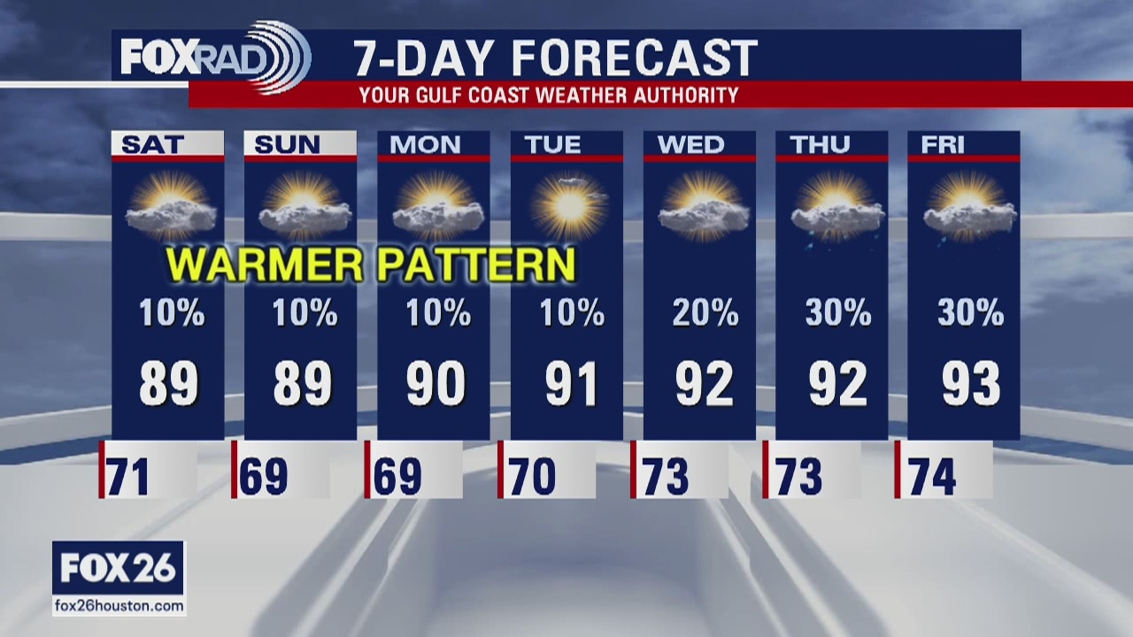
Less rain. More heat. Overall pretty quiet for several days.
Less rain. More heat. Overall pretty quiet for several days.
Friday weather and the weekend outlook
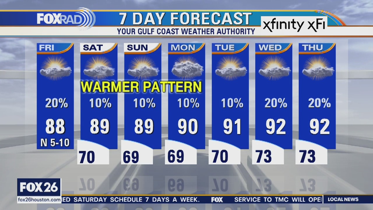
There will be a chance for a few widely scattered showers late today, but overall our pattern is shifting to a warm and drier regime for several days. Look for highs near 90 and lows near 70 with only isolated showers possible through early next week.
There will be a chance for a few widely scattered showers late today, but overall our pattern is shifting to a warm and drier regime for several days. Look for highs near 90 and lows near 70 with only isolated showers possible through early next week.
Thursday Evening Weather Forecast
Your Gulf Coast Weather Authority Chief Meteorologist Dr. Jim Siebert gives you a look ahead at Thursday night's weather.
Your Gulf Coast Weather Authority Chief Meteorologist Dr. Jim Siebert gives you a look ahead at Thursday night's weather.
Thursday weather forecast
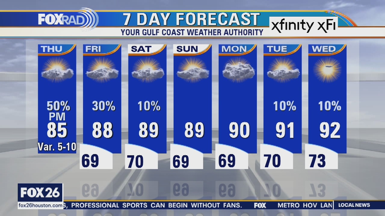
Isolated morning showers, then some midday clearing followed by scattered afternoon storms. Highs in the mid 80s.
Isolated morning showers, then some midday clearing followed by scattered afternoon storms. Highs in the mid 80s.
Thursday Morning Weather Forecast
Your Gulf Coast Weather Authority Chief Meteorologist Dr. Jim Siebert gives you a look at when rainfall will return to the Houston area.
Your Gulf Coast Weather Authority Chief Meteorologist Dr. Jim Siebert gives you a look at when rainfall will return to the Houston area.
Wednesday Evening Weather Forecast
Your Gulf Coast Weather Authority Chief Meteorologist Dr. Jim Siebert tells you about more showers headed our way this evening.
Your Gulf Coast Weather Authority Chief Meteorologist Dr. Jim Siebert tells you about more showers headed our way this evening.
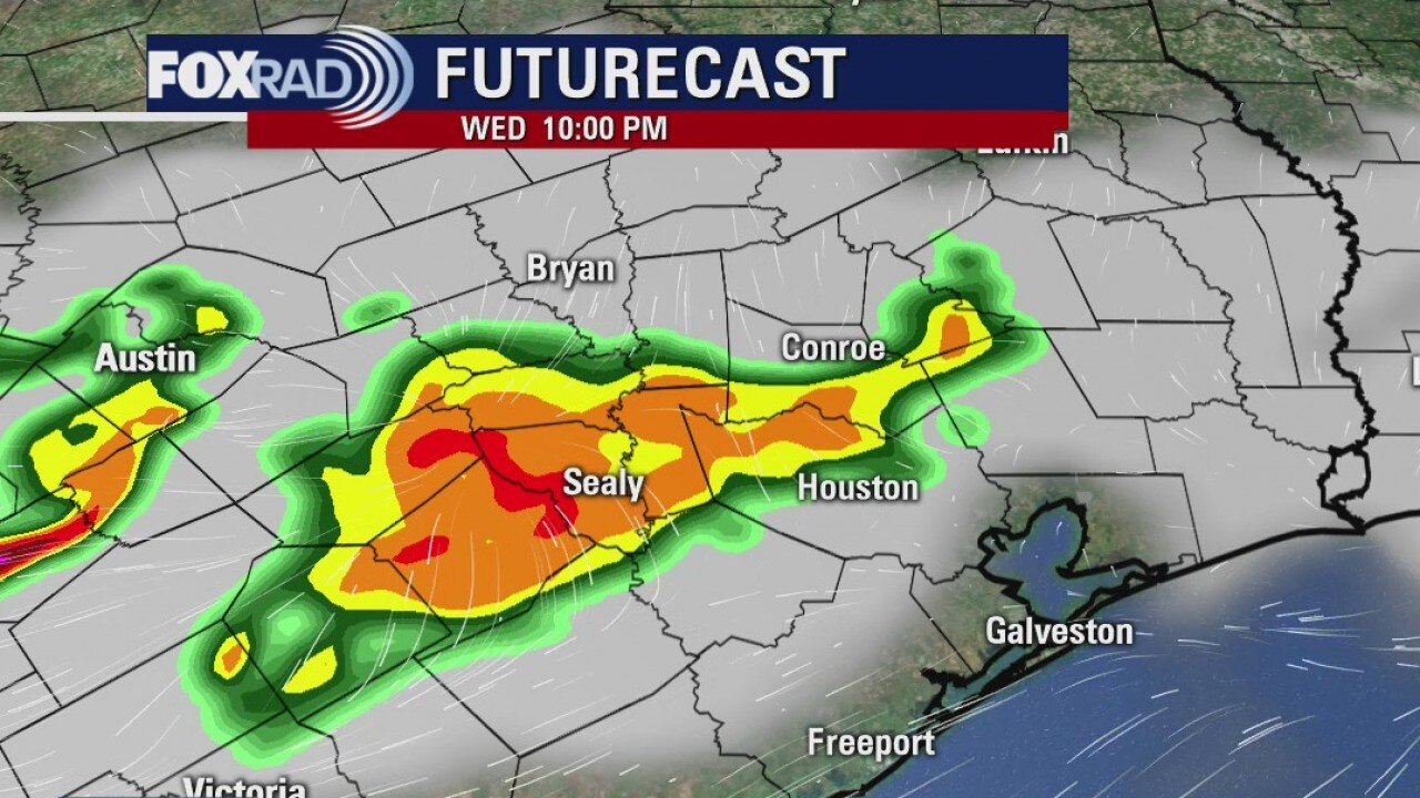
Wednesday weather forecast
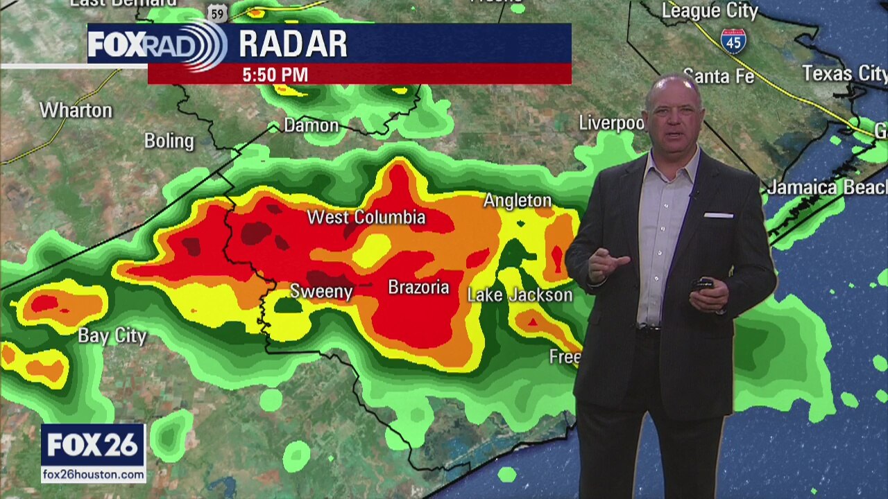
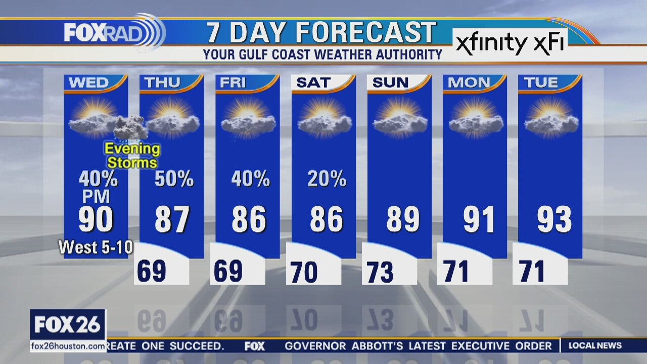
Stay weather alert today because we could transition quickly from sunny and hot weather to stormy weather by late today. Watch for scattered severe storms that could move in from the northwest beginning around 3-5pm and lasting until around 7-9pm. Hail and high winds will be possible. Scattered storms are also possible Thursday and Friday before rain chances go down and hotter weather returns.
Stay weather alert today because we could transition quickly from sunny and hot weather to stormy weather by late today. Watch for scattered severe storms that could move in from the northwest beginning around 3-5pm and lasting until around 7-9pm. Hail and high winds will be possible. Scattered storms are also possible Thursday and Friday before rain chances go down and hotter weather returns.