

Something new in the forecast: showers
Here?s something different: there?s a chance for mainly afternoon showers just about every day starting on Friday. It will help knock the temperatures down a little and that sounds good to Chief Meteorologist Dr. Jim Siebert.
Here?s something different: there?s a chance for mainly afternoon showers just about every day starting on Friday. It will help knock the temperatures down a little and that sounds good to Chief Meteorologist Dr. Jim Siebert.
Thursday Evening Weather Forecast
There?s a chance for mainly afternoon showers just about every day starting on Fri. It will help knock the temps down a little and that sounds good to me.
There?s a chance for mainly afternoon showers just about every day starting on Fri. It will help knock the temps down a little and that sounds good to me.
Thursday weather forecast
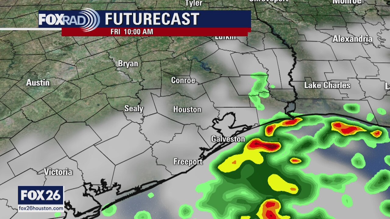
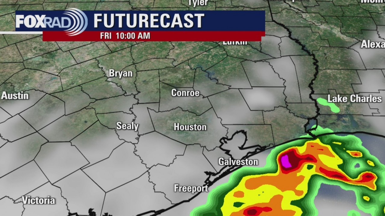
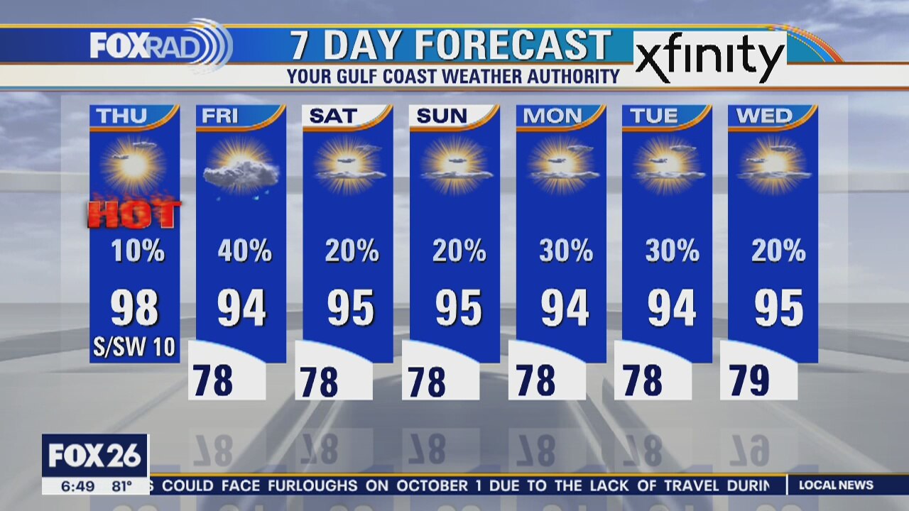
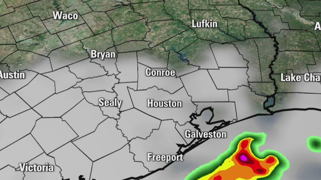
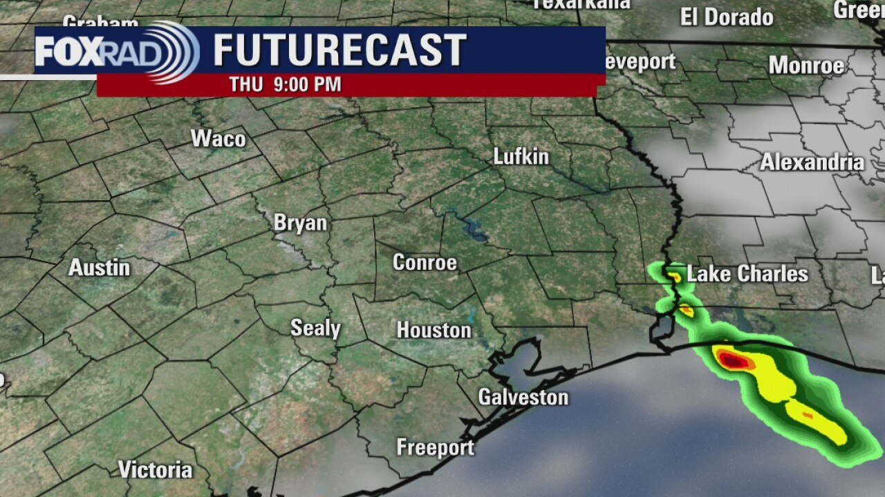
It looks like we?ll have one more day of upper 90s before a return to normal summer warmth and a daily chance for showers. Watch for highs today near 98 with a heat index near 105. A stray shower is possible today, but the chance for rain rises to 40% Friday and that should begin a rerun to more moderate temperatures.
It looks like we?ll have one more day of upper 90s before a return to normal summer warmth and a daily chance for showers. Watch for highs today near 98 with a heat index near 105. A stray shower is possible today, but the chance for rain rises to 40% Friday and that should begin a rerun to more moderate temperatures.
Thursday morning weather forecast
We aren?t talking a lot of rain, but there?s a chance for a little relief from the heat. The coming week will have better rain chances.
We aren?t talking a lot of rain, but there?s a chance for a little relief from the heat. The coming week will have better rain chances.
Wednesday Evening Weather Forecast
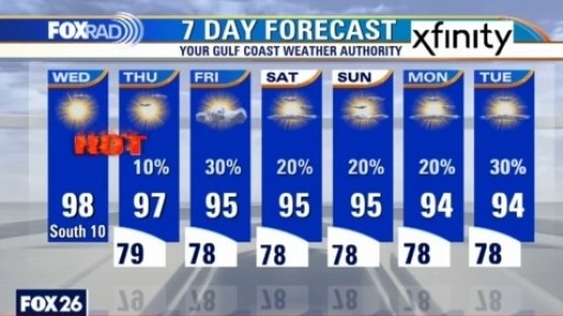
Thursday will bring a 10% chance for mainly an afternoon shower and it goes up to 30% on Friday. We aren?t talking a lot of rain, but there?s a chance for a little relief from the heat. The coming week will have better rain chances.
Thursday will bring a 10% chance for mainly an afternoon shower and it goes up to 30% on Friday. We aren?t talking a lot of rain, but there?s a chance for a little relief from the heat. The coming week will have better rain chances.
Wednesday weather forecast
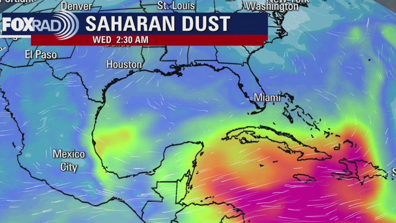
Summer heat and humidity will remain in place today. Look for highs in the mid to upper 90s with a heat index near 105. There is a slight chance for sprinkles north. Thursday will be steamy again, but Friday should bring a few showers and more ?normal? heat. You may also notice the return of Saharan haze over the next few days.
Summer heat and humidity will remain in place today. Look for highs in the mid to upper 90s with a heat index near 105. There is a slight chance for sprinkles north. Thursday will be steamy again, but Friday should bring a few showers and more ?normal? heat. You may also notice the return of Saharan haze over the next few days.
Wednesday morning weather update
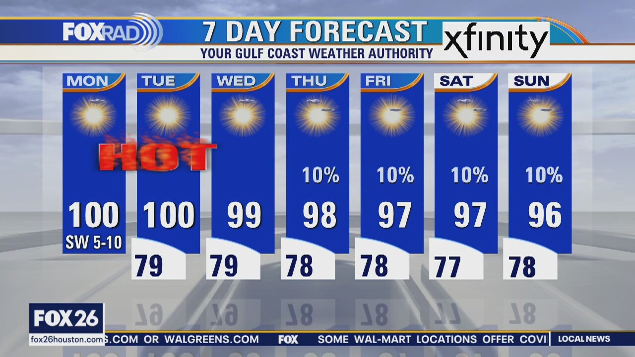
Temps will drop a little over the rest of the week and rain chances will slowly return. Our weather will be a bit closer to normal, which still means hot and humid. These are small changes, but we?ll take them.
Temps will drop a little over the rest of the week and rain chances will slowly return. Our weather will be a bit closer to normal, which still means hot and humid. These are small changes, but we?ll take them.
Tuesday evening weather forecast
Temps will drop a little over the rest of the week and rain chances will slowly return. Our weather will be a bit closer to normal, which still means hot and humid. These are small changes, but we?ll take them.
Temps will drop a little over the rest of the week and rain chances will slowly return. Our weather will be a bit closer to normal, which still means hot and humid. These are small changes, but we?ll take them.
Tuesday weather forecast
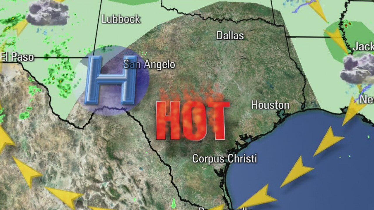
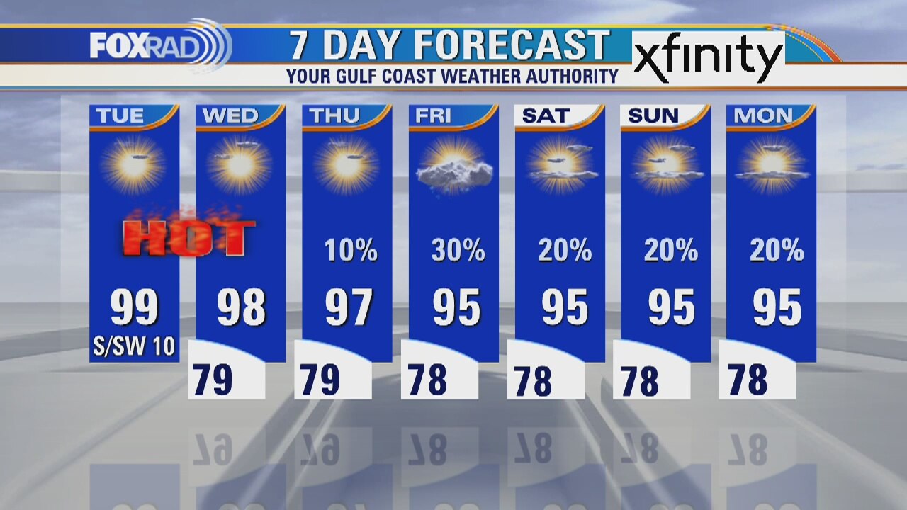
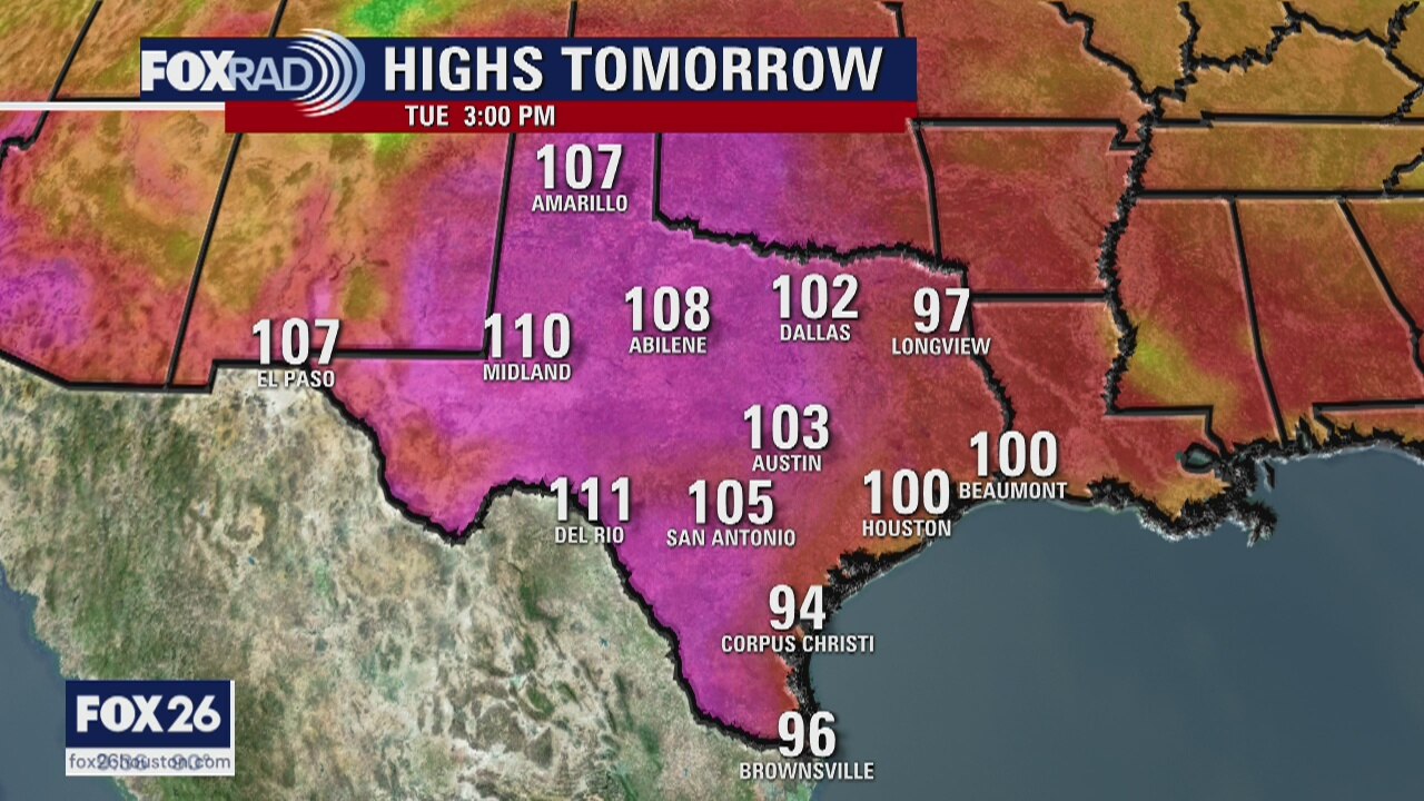
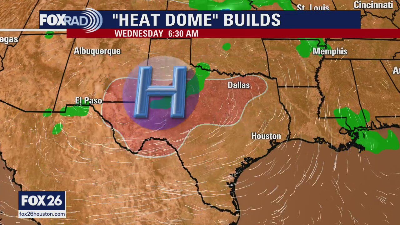
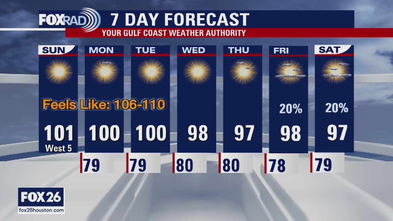
Our heat wave will continue for a few more days, but some help could be on the way by Friday. We?ve hit highs in the triple digits for three of the last four days in Houston and today will be close. By Friday, the ?heat dome? that?s been dominating for the past several days will weaken and allow for scattered showers and ?normal heat? in the mid 90s.
Our heat wave will continue for a few more days, but some help could be on the way by Friday. We?ve hit highs in the triple digits for three of the last four days in Houston and today will be close. By Friday, the ?heat dome? that?s been dominating for the past several days will weaken and allow for scattered showers and ?normal heat? in the mid 90s.
The heat continues
It?s not a big surprise that another Heat Advisory is posted for all of southeast Texas on Tuesday. We will start to see temperatures trend downward by the end of the week, but it will only be by a few degrees.
It?s not a big surprise that another Heat Advisory is posted for all of southeast Texas on Tuesday. We will start to see temperatures trend downward by the end of the week, but it will only be by a few degrees.
Monday Evening Weather Forecast
The weather will remain hot and humid all week long. Heat Advisories are posted through Tue. Rain chances don?t even become slight until the end of the week. Temps will drop a little, but we won?t feel much of a difference.
The weather will remain hot and humid all week long. Heat Advisories are posted through Tue. Rain chances don?t even become slight until the end of the week. Temps will drop a little, but we won?t feel much of a difference.
Monday weather forecast
A heat advisory is in effect today until 8 p.m. High temperatures in most spots will reach the upper 90s with a heat index between 105 and 110. Sizzling heat will continue in Central and West Texas with actual highs there near 110. The overall weather pattern should change slightly by late this week giving us mid 90s rather than upper 90s.
A heat advisory is in effect today until 8 p.m. High temperatures in most spots will reach the upper 90s with a heat index between 105 and 110. Sizzling heat will continue in Central and West Texas with actual highs there near 110. The overall weather pattern should change slightly by late this week giving us mid 90s rather than upper 90s.
Monday morning weather forecast
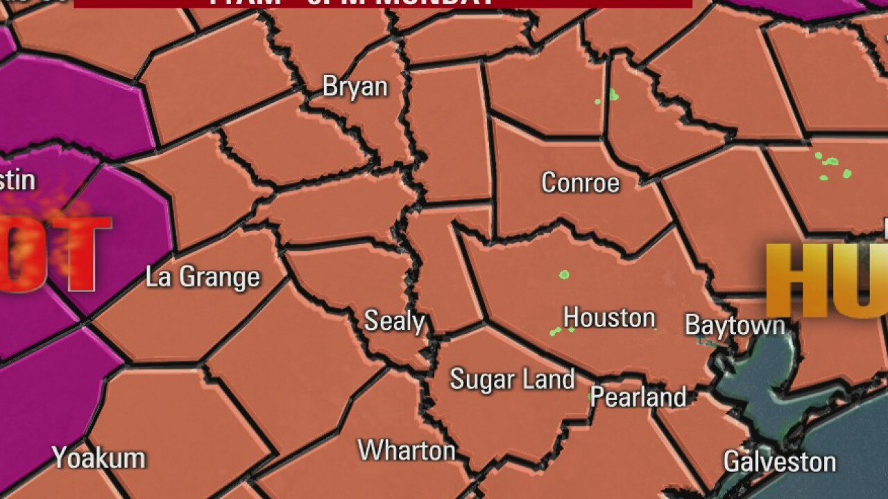
Another HEAT ADVISORY for Monday in Southeast Texas. Use caution if you are working or playing outdoors. Don't look for much rain this week. It's going to be more days of hot and humid in Houston.
Another HEAT ADVISORY for Monday in Southeast Texas. Use caution if you are working or playing outdoors. Don't look for much rain this week. It's going to be more days of hot and humid in Houston.
Sunday evening weather forecast
Another HEAT ADVISORY for Monday in Southeast Texas. Use caution if you are working or playing outdoors. Don't look for much rain this week. It's going to be more days of hot and humid in Houston.
Another HEAT ADVISORY for Monday in Southeast Texas. Use caution if you are working or playing outdoors. Don't look for much rain this week. It's going to be more days of hot and humid in Houston.
Houston-area weather forecast 7/12
Another heat advisory for another hot and humid day across southeast Texas. While we may see a few more clouds, they won't be producing any rain. Temperatures will near 100 again today with feels like temperatures ranging between 106-110. Much of next week will remain hot with rain chances finally returning by Friday. Stay cool!
Another heat advisory for another hot and humid day across southeast Texas. While we may see a few more clouds, they won't be producing any rain. Temperatures will near 100 again today with feels like temperatures ranging between 106-110. Much of next week will remain hot with rain chances finally returning by Friday. Stay cool!
Sunday morning weather forecast
Houston hit 101 on Saturday making it the hottest day of 2020. We are in the middle of a heat wave. The National Weather Service has issued a Heat Advisory again for Sunday from 11am-8pm. Be safe outdoors!
Houston hit 101 on Saturday making it the hottest day of 2020. We are in the middle of a heat wave. The National Weather Service has issued a Heat Advisory again for Sunday from 11am-8pm. Be safe outdoors!

Saturday Evening Weather Forecast
A Heat Advisory has been extended for SE Texas and Houston through Sunday. Heat Warnings are posted for areas like north Texas and Oklahoma. We can expect more heat well into the coming week.
A Heat Advisory has been extended for SE Texas and Houston through Sunday. Heat Warnings are posted for areas like north Texas and Oklahoma. We can expect more heat well into the coming week.
Houston-area weather forecast 7/11
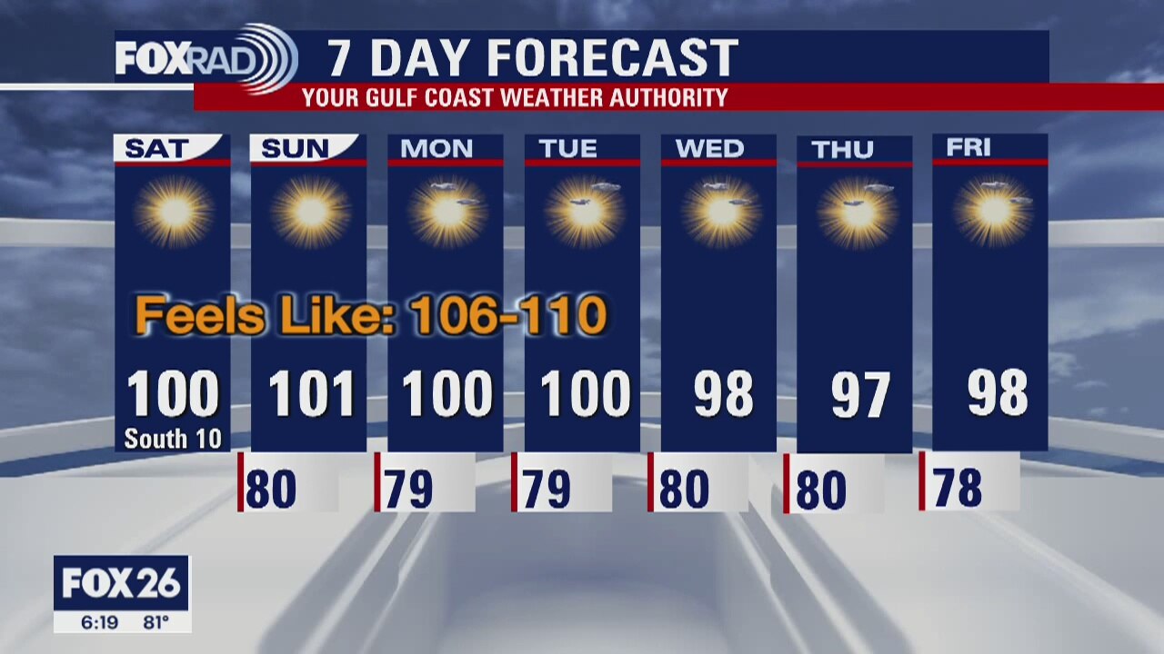
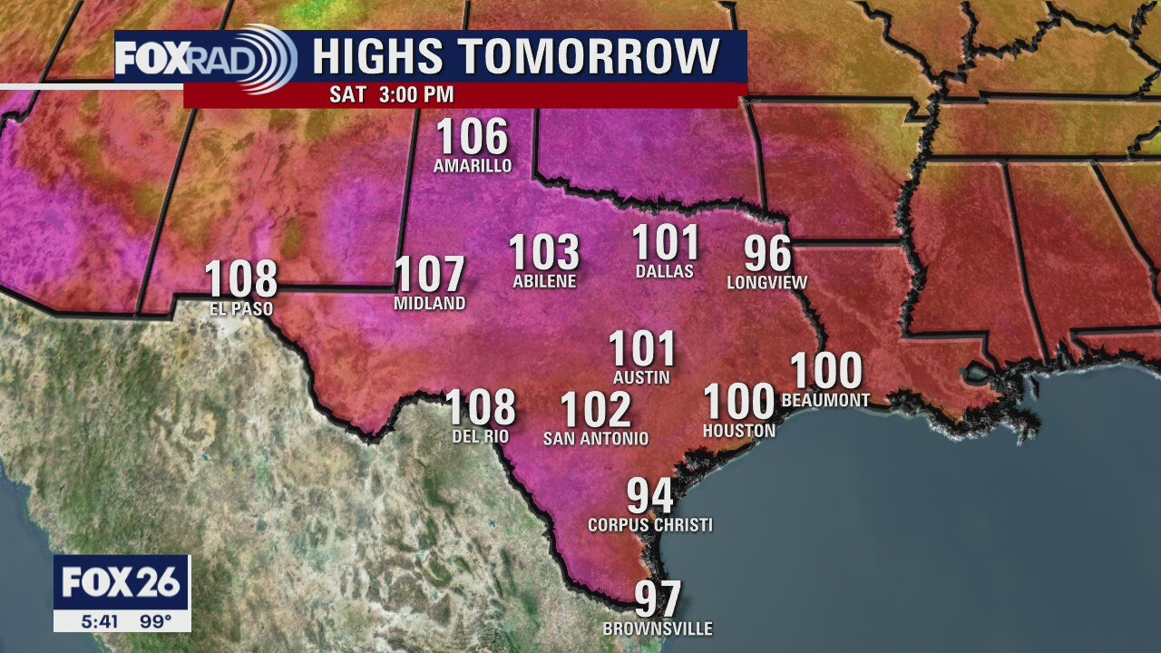
The hottest air of the season has arrived in Houston. A heat advisory has been issued for Saturday and will likely be extended. Warm nights followed by hot days will provide little opportunity to cool off. Highs will be soaring into the upper 90s and low 100s with feels like temperatures between 106-110. Stay cool!
The hottest air of the season has arrived in Houston. A heat advisory has been issued for Saturday and will likely be extended. Warm nights followed by hot days will provide little opportunity to cool off. Highs will be soaring into the upper 90s and low 100s with feels like temperatures between 106-110. Stay cool!
Saturday morning weather forecast
It will take a long road trip if you’re trying to get away from the heat. Advisories are posted for most of Texas, all of Louisiana and well into other nearby states. It’s going to be a sizzling summer weekend, so stay cool any way you can.
It will take a long road trip if you’re trying to get away from the heat. Advisories are posted for most of Texas, all of Louisiana and well into other nearby states. It’s going to be a sizzling summer weekend, so stay cool any way you can.
Friday Evening Weather Forecast
Heat Advisories have already been extended into Saturday and there will be more going into the coming week. Highs are expected to be in the low 100s until Tue or Wed. There is no rain in the forecast, so stay cool as best you can.
Heat Advisories have already been extended into Saturday and there will be more going into the coming week. Highs are expected to be in the low 100s until Tue or Wed. There is no rain in the forecast, so stay cool as best you can.