

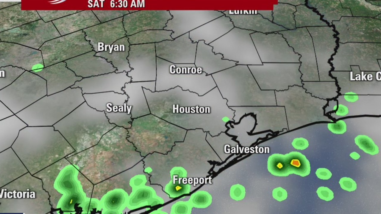
More rain on the way
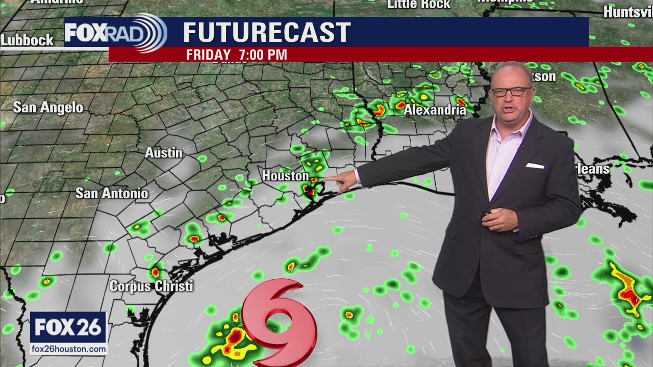
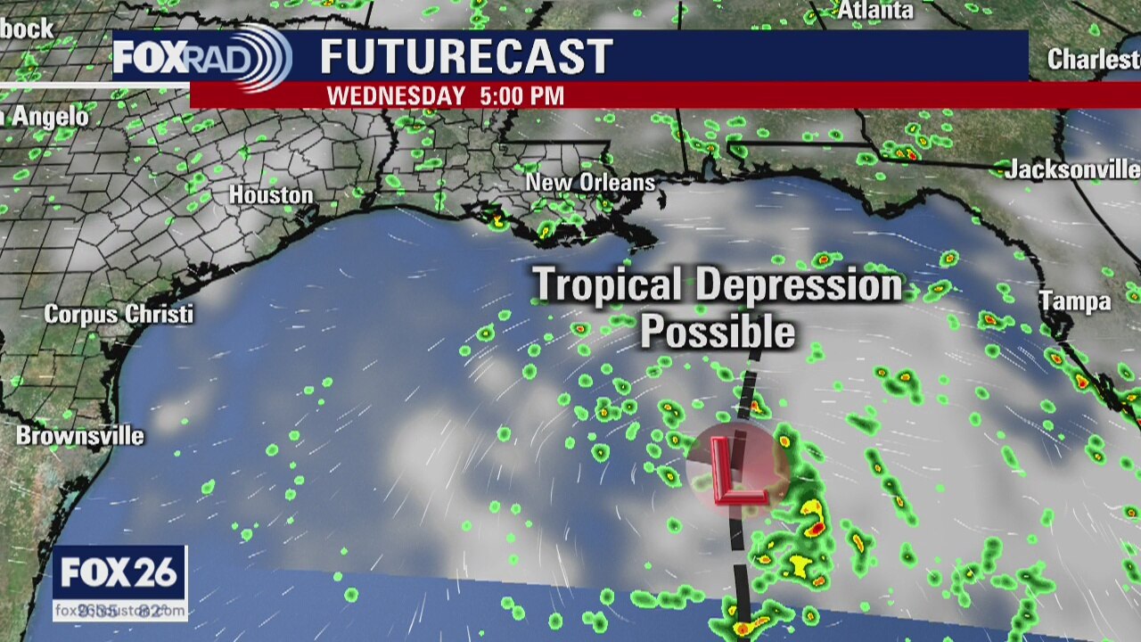
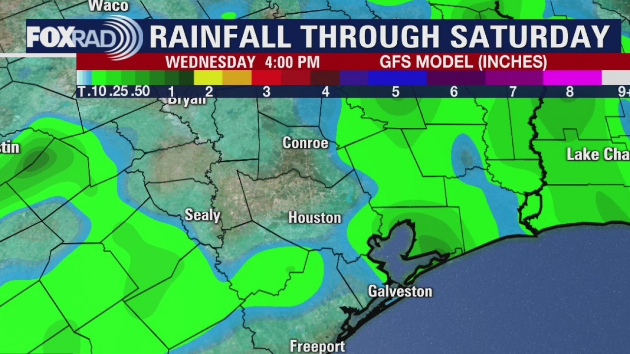
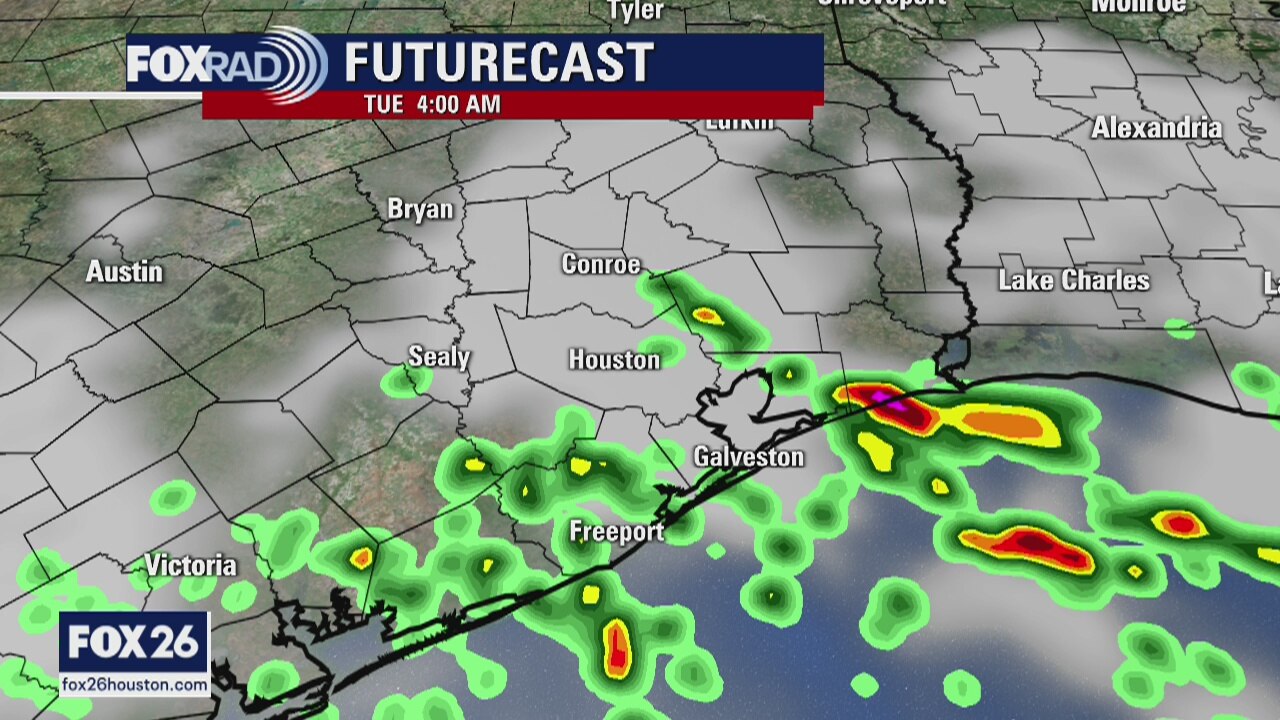
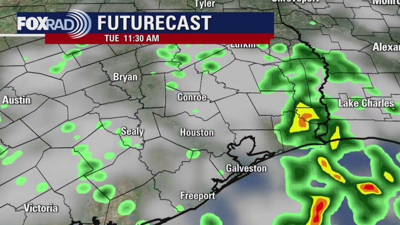
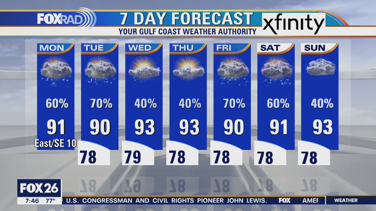
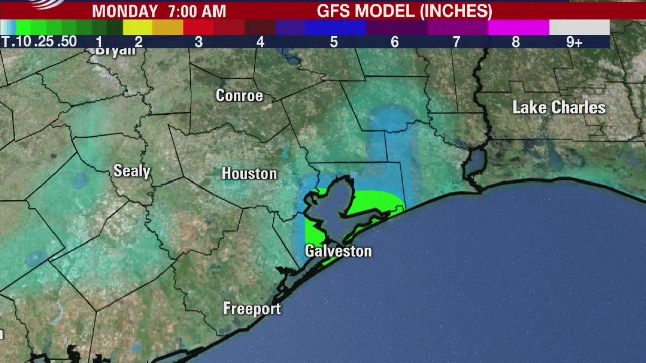
The impacts for the Houston area from what will be Tropical Storm Hanna will mostly be periods of rainfall, with it being heavy at times and elevated tides. Rain will be in the forecast into next week as more moisture streams in from the Gulf.
The impacts for the Houston area from what will be Tropical Storm Hanna will mostly be periods of rainfall, with it being heavy at times and elevated tides. Rain will be in the forecast into next week as more moisture streams in from the Gulf.
Tropical Depression 8 forms in the Gulf of Mexico
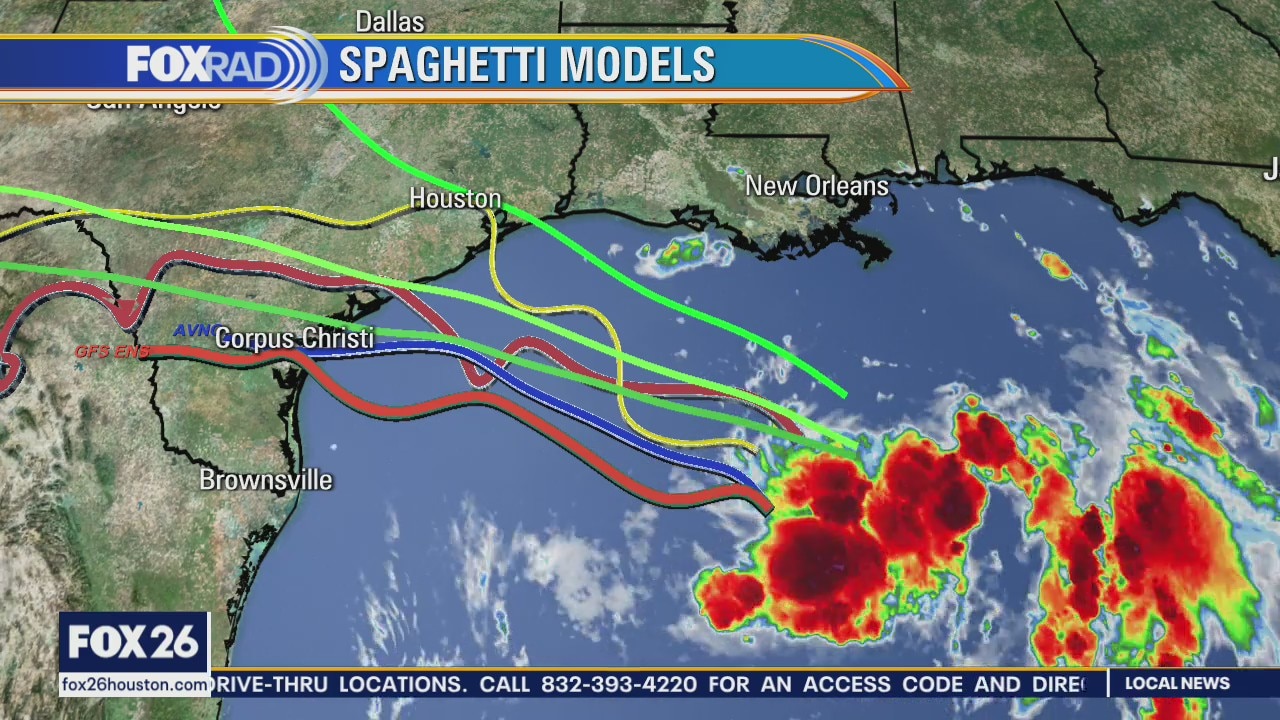
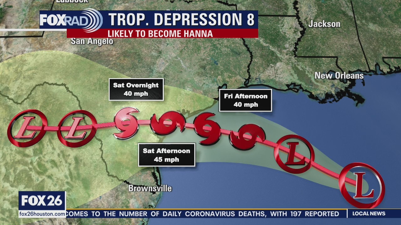
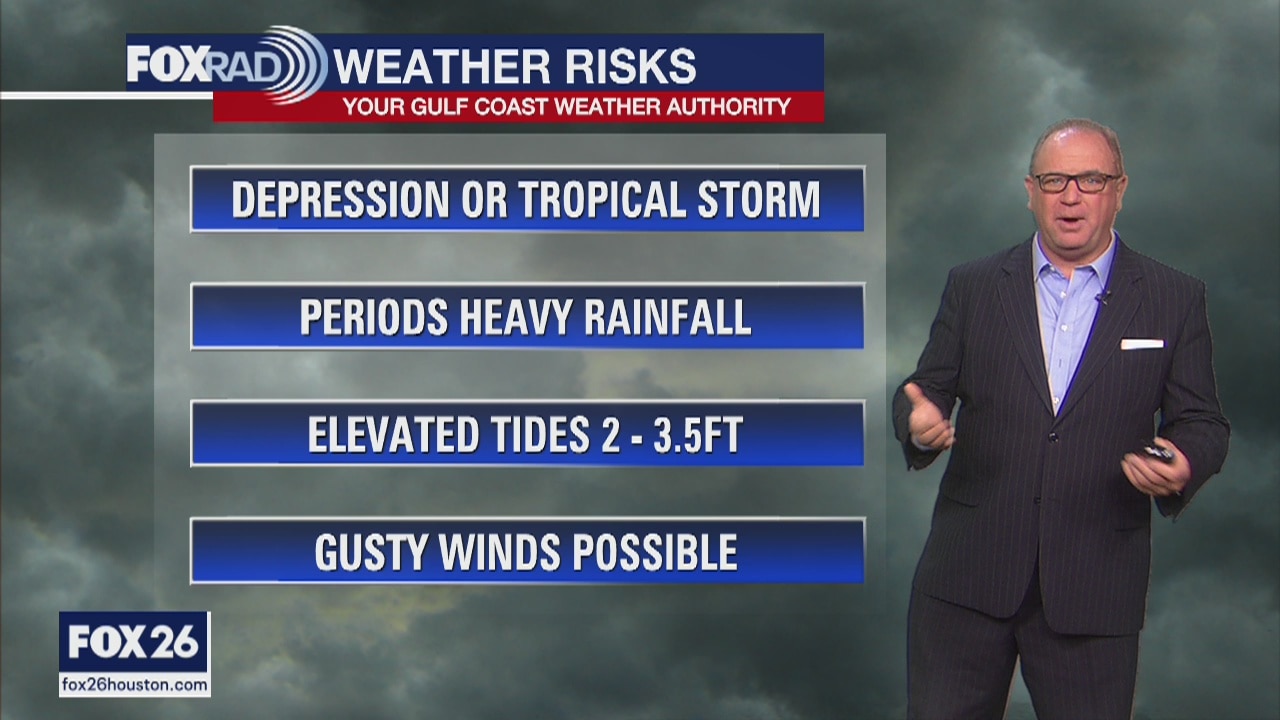
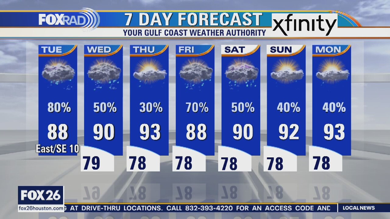
As tropical depression 8 develops into Hanna in the Gulf, our weather today should be hot and humid with just a few passing storms. Conditions go downhill late Friday through the weekend with the center of a Hanna likely passing to our south. We could receive more than 6? of rain and notice higher than normal tide levels along the coast. A tropical storm watch is in effect for the entire Texas coastline.
As tropical depression 8 develops into Hanna in the Gulf, our weather today should be hot and humid with just a few passing storms. Conditions go downhill late Friday through the weekend with the center of a Hanna likely passing to our south. We could receive more than 6? of rain and notice higher than normal tide levels along the coast. A tropical storm watch is in effect for the entire Texas coastline.
Tropical Depression 8 forms in the Gulf
As tropical depression 8 develops into Hanna in the Gulf, our weather today should be hot and humid with just a few passing storms. Conditions go downhill late Friday through the weekend with the center of a Hanna likely passing to our south. We could receive more than 6? of rain and notice higher than normal tide levels along the coast. A tropical storm watch is in effect for the entire Texas coastline.
As tropical depression 8 develops into Hanna in the Gulf, our weather today should be hot and humid with just a few passing storms. Conditions go downhill late Friday through the weekend with the center of a Hanna likely passing to our south. We could receive more than 6? of rain and notice higher than normal tide levels along the coast. A tropical storm watch is in effect for the entire Texas coastline.
Thursday morning weather forecast
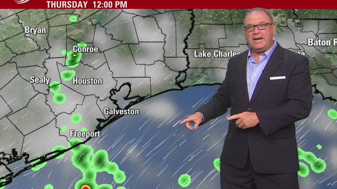
Scattered showers are possible on Thur, but more widespread rainfall is likely on Friday and into Saturday as a tropical disturbance arrives. It may be a tropical depression or storm, but it mainly looks like showers and not a big wind event.
Scattered showers are possible on Thur, but more widespread rainfall is likely on Friday and into Saturday as a tropical disturbance arrives. It may be a tropical depression or storm, but it mainly looks like showers and not a big wind event.
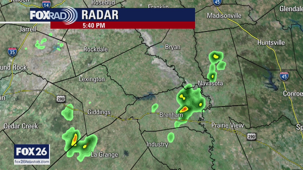
Rain and tropical disturbance ahead
Scattered showers are possible on Thursday, but more widespread rainfall is likely on Friday and into Saturday as a tropical disturbance arrives. It may be a tropical depression or storm, but it mainly looks like showers and not a big wind event.
Scattered showers are possible on Thursday, but more widespread rainfall is likely on Friday and into Saturday as a tropical disturbance arrives. It may be a tropical depression or storm, but it mainly looks like showers and not a big wind event.

Monitoring the tropical wave in the Gulf
Tropical Storm Gonzalo formed in the Atlantic on Tuesday, and a tropical wave in the Gulf has a 50% risk of becoming a depression.
Tropical Storm Gonzalo formed in the Atlantic on Tuesday, and a tropical wave in the Gulf has a 50% risk of becoming a depression.
Keeping our eye on the Gulf
More on-and-off rain is expected over the next few days with temps a little below normal. We are watching a tropical wave enter the Gulf to see if it will organize into a depression or storm. Whatever it is will bring more rain to SE Texas on Friday.
More on-and-off rain is expected over the next few days with temps a little below normal. We are watching a tropical wave enter the Gulf to see if it will organize into a depression or storm. Whatever it is will bring more rain to SE Texas on Friday.
Tuesday Evening Weather Forecast
More on-and-off rain is expected over the next few days with temps a little below normal. We are watching a tropical wave enter the Gulf to see if it will organize into a depression or storm. Whatever it is will bring more rain to SE Texas on Friday.
More on-and-off rain is expected over the next few days with temps a little below normal. We are watching a tropical wave enter the Gulf to see if it will organize into a depression or storm. Whatever it is will bring more rain to SE Texas on Friday.
Tuesday weather forecast
The first of two tropical waves will bring locally heavy rain and lots of lightning at times today. Highs should be held into the mid to upper 80s. Watch for scattered storms Wednesday, then a hot and humid day on Thursday. On Friday, it looks like a tropical wave or possible depression will move in and bring a round of downpours.
The first of two tropical waves will bring locally heavy rain and lots of lightning at times today. Highs should be held into the mid to upper 80s. Watch for scattered storms Wednesday, then a hot and humid day on Thursday. On Friday, it looks like a tropical wave or possible depression will move in and bring a round of downpours.
Rain every day
Rain is expected every day this week, but it mostly looks like scattered showers without big problems. Flooding is not expected. The National Hurricane Center has increased the risk to 30% for a tropical wave to become some type of organized tropical low. That?s not a big change and the models still don?t indicate a strong system, but we will know more as it enters the Gulf on Tuesday.
Rain is expected every day this week, but it mostly looks like scattered showers without big problems. Flooding is not expected. The National Hurricane Center has increased the risk to 30% for a tropical wave to become some type of organized tropical low. That?s not a big change and the models still don?t indicate a strong system, but we will know more as it enters the Gulf on Tuesday.
Wednesday Evening Weather Forecast
A broad low is just offshore and will send showers into SE Texas through Tue. Flooding is not expected. Another low will move into the Gulf and has a 20% risk of organizing, but right now only looks to send more scattered showers later in the week. We will monitor it closely.
A broad low is just offshore and will send showers into SE Texas through Tue. Flooding is not expected. Another low will move into the Gulf and has a 20% risk of organizing, but right now only looks to send more scattered showers later in the week. We will monitor it closely.
Monday weather forecast
This week?s weather will be just about the opposite of last week?s. Rather than a dome of high pressure, a general area (or areas) of low pressure will hang around. This should result in a daily round of storms along with high temps at or below normal.
This week?s weather will be just about the opposite of last week?s. Rather than a dome of high pressure, a general area (or areas) of low pressure will hang around. This should result in a daily round of storms along with high temps at or below normal.
Monday morning weather forecast
Deeper Gulf moisture moves into Southeast Texas on Monday and Tuesday bringing rain chances back to the forecast. We are watching the Gulf for a potential tropical depression or tropical storm to form later in the week. The National Hurricane Center gives it a 20% chance of forming over the next 5 days. Look for more higher rain chances at the end of the week depending on how that develops.
Deeper Gulf moisture moves into Southeast Texas on Monday and Tuesday bringing rain chances back to the forecast. We are watching the Gulf for a potential tropical depression or tropical storm to form later in the week. The National Hurricane Center gives it a 20% chance of forming over the next 5 days. Look for more higher rain chances at the end of the week depending on how that develops.
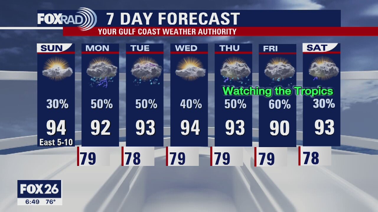
Houston-area weather forecast 7/19
Rain chances will gradually be increasing as we kickoff this week. Daily shower and storm chances will be highest on Monday and Tuesday before our attention turns to a tropical wave that will be pushing into the Gulf of Mexico late next week. At the least, expect rain chances to stick around essentially everyday. Highs will continue to reach the low and mid 90s with feels-like temperatures reaching the triple-digits.
Rain chances will gradually be increasing as we kickoff this week. Daily shower and storm chances will be highest on Monday and Tuesday before our attention turns to a tropical wave that will be pushing into the Gulf of Mexico late next week. At the least, expect rain chances to stick around essentially everyday. Highs will continue to reach the low and mid 90s with feels-like temperatures reaching the triple-digits.
Sunday morning weather forecast
It's July, so you know the forecast is hot for Houston. But maybe not as hot as some of last week. We also have rain chances everyday this coming week. Don't look for anything too strong but you may want to keep the umbrella with you if you are venturing out of the house. Download the FOX26 Weather App to track the showers and isolated storms!
It's July, so you know the forecast is hot for Houston. But maybe not as hot as some of last week. We also have rain chances everyday this coming week. Don't look for anything too strong but you may want to keep the umbrella with you if you are venturing out of the house. Download the FOX26 Weather App to track the showers and isolated storms!
Saturday evening weather forecast
It's July, so you know the forecast is hot for Houston. But maybe not as hot as some of last week. We also have rain chances everyday this coming week. Don't look for anything too strong but you may want to keep the umbrella with you if you are venturing out of the house. Download the FOX26 Weather App to track the showers and isolated storms!
It's July, so you know the forecast is hot for Houston. But maybe not as hot as some of last week. We also have rain chances everyday this coming week. Don't look for anything too strong but you may want to keep the umbrella with you if you are venturing out of the house. Download the FOX26 Weather App to track the showers and isolated storms!
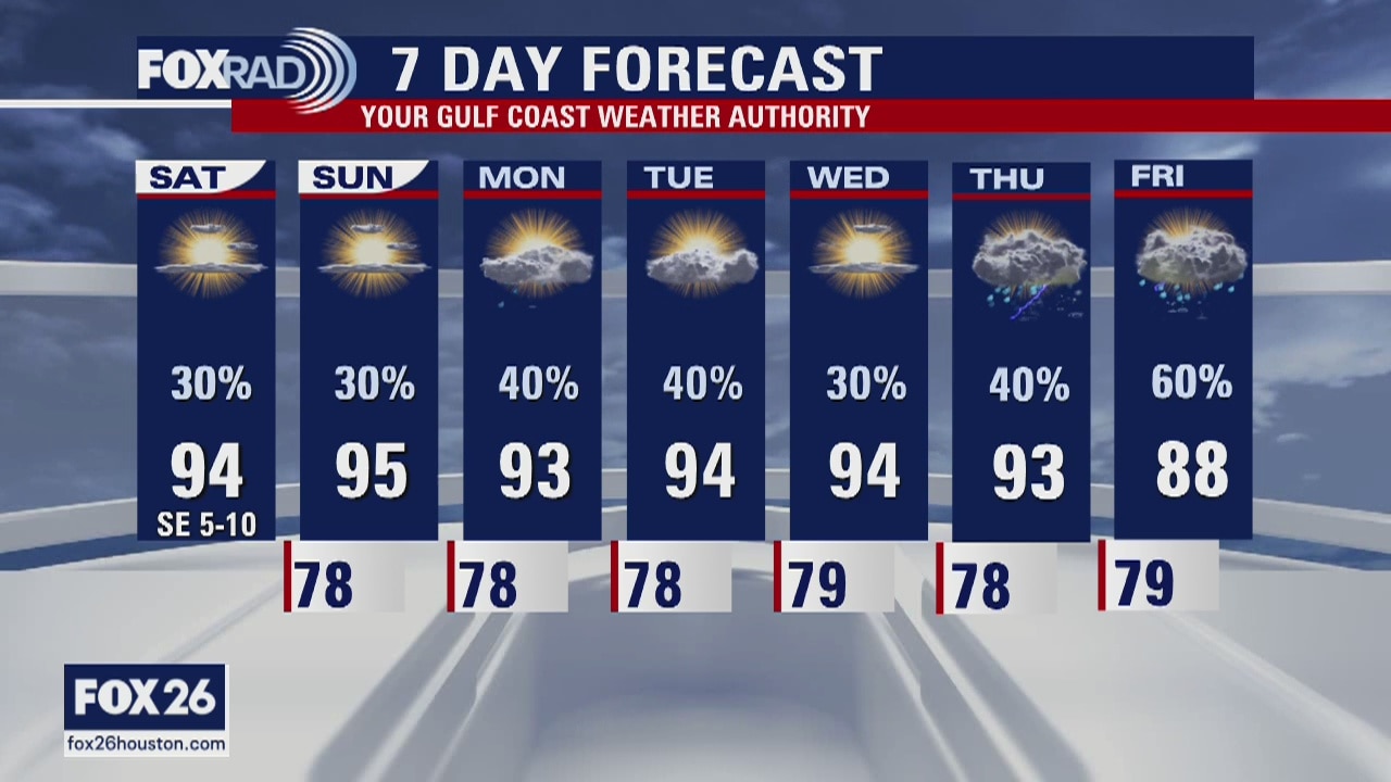
Houston-area weather forecast 7/18
After parts of the Houston-area saw rain on Friday, more showers are expected on Saturday. Temperatures will warm into the low and mid 90s with feels like temperatures reaching the triple-digits. Rain chances, in fact, will stick around all week long as we head toward next weekend, and that is when we could see some deeper tropical moisture arrive.
After parts of the Houston-area saw rain on Friday, more showers are expected on Saturday. Temperatures will warm into the low and mid 90s with feels like temperatures reaching the triple-digits. Rain chances, in fact, will stick around all week long as we head toward next weekend, and that is when we could see some deeper tropical moisture arrive.
Saturday morning weather forecast
The weekend will bring hot conditions with a chance for mainly afternoon showers with some thunder. The coming week will bring a daily chance for rain with better chances on Wed and Fri. Nothing looks particularly strong.
The weekend will bring hot conditions with a chance for mainly afternoon showers with some thunder. The coming week will bring a daily chance for rain with better chances on Wed and Fri. Nothing looks particularly strong.
Friday night forecast
The weekend will bring hot conditions with a chance for mainly afternoon showers with some thunder. The coming week will bring a daily chance for rain with better chances on Wednesday and Friday. Nothing looks particularly strong.
The weekend will bring hot conditions with a chance for mainly afternoon showers with some thunder. The coming week will bring a daily chance for rain with better chances on Wednesday and Friday. Nothing looks particularly strong.

Friday weather forecast
Our heat wave is finally breaking with showers and storms likely today and at least isolated storms for the weekend and beyond. Increasing clouds and showers should hold our high temperatures into the low to mid 90s rather than upper 90s and low 100s. An occasional heavy downpour is possible.
Our heat wave is finally breaking with showers and storms likely today and at least isolated storms for the weekend and beyond. Increasing clouds and showers should hold our high temperatures into the low to mid 90s rather than upper 90s and low 100s. An occasional heavy downpour is possible.