

Monday weather forecast
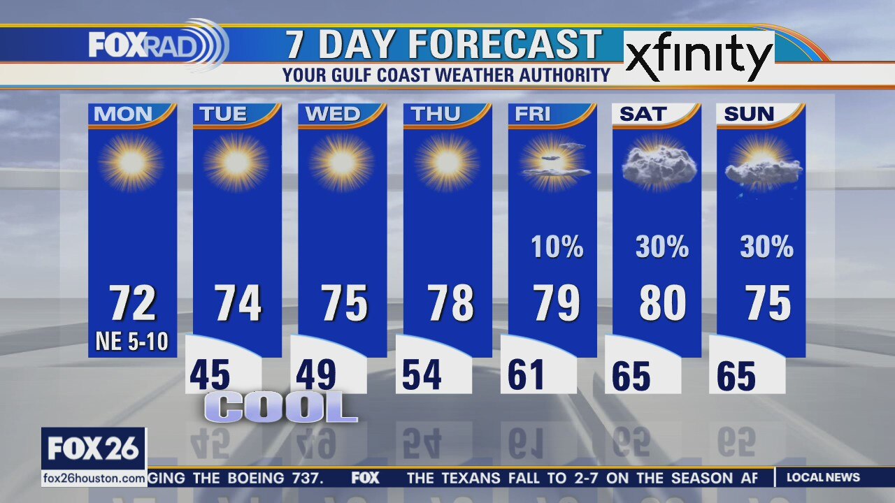
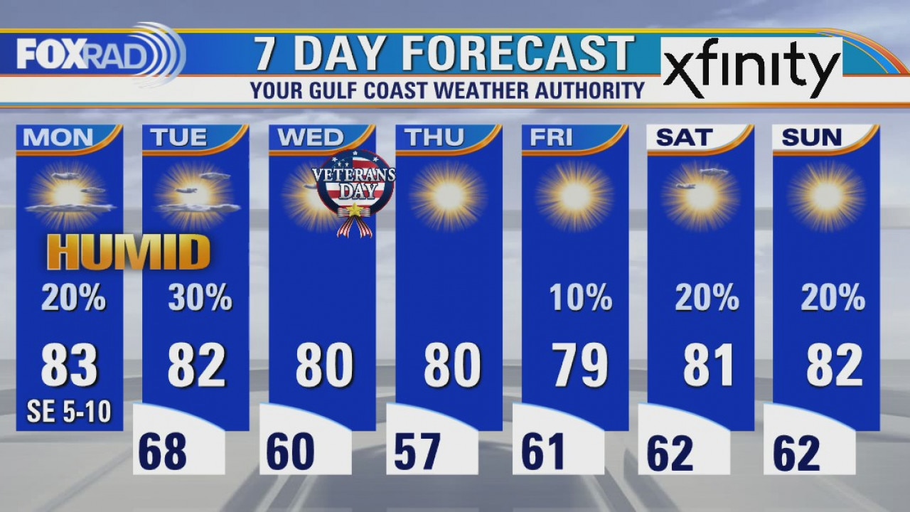
Weather this week is about as good as it gets. Look for overnight lows in the 40s with sunny afternoons and highs in the 70s. Humidity will stay very low until late this week when winds will slowly return some moisture from the Gulf. Meanwhile, Central America is about take a direct hit from a historic major hurricane Iota.
Weather this week is about as good as it gets. Look for overnight lows in the 40s with sunny afternoons and highs in the 70s. Humidity will stay very low until late this week when winds will slowly return some moisture from the Gulf. Meanwhile, Central America is about take a direct hit from a historic major hurricane Iota.
Monday morning weather forecast
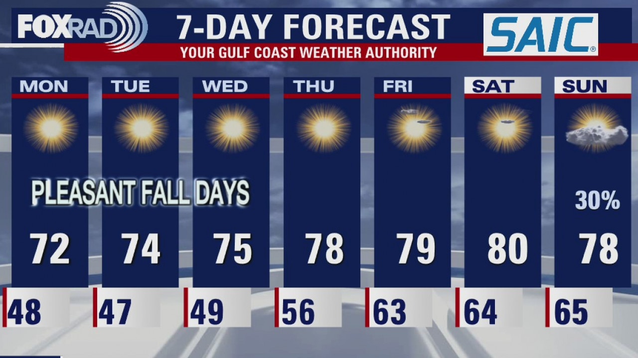
This is how most of us like our days in November. Houston feeling cooler and much drier today with a cold front blowing through in the morning. Expect more nice days ahead with very little chances for rain.
This is how most of us like our days in November. Houston feeling cooler and much drier today with a cold front blowing through in the morning. Expect more nice days ahead with very little chances for rain.
Houston-area weather forecast 11/15
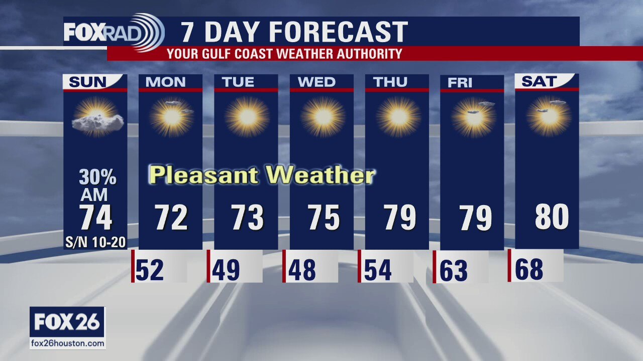
Here comes the cold front! Right on schedule, winds will shift as the front moves through. A thin line of showers will accompany the front and temperatures will drop some 10 degrees as it pushes through. Clouds should clear later today and with lower humidity, Sunday is shaping up to be a pretty nice day. The whole week, in fact, looking very pleasant with the coolest temperatures coming Tuesday and Wednesday morning.
Here comes the cold front! Right on schedule, winds will shift as the front moves through. A thin line of showers will accompany the front and temperatures will drop some 10 degrees as it pushes through. Clouds should clear later today and with lower humidity, Sunday is shaping up to be a pretty nice day. The whole week, in fact, looking very pleasant with the coolest temperatures coming Tuesday and Wednesday morning.
Sunday morning weather forecast
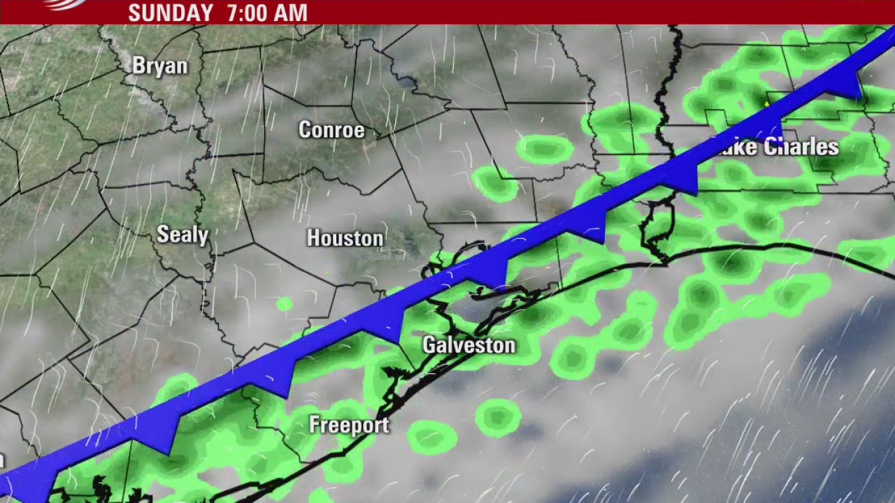
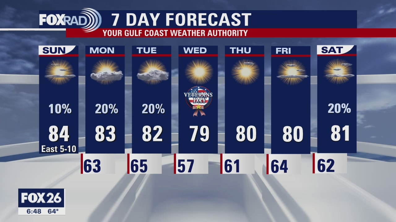
Look for a cold front to move across the Houston area early on Sunday morning. Highest chances for rain come around sunrise. The afternoon will be breezy as north winds bring cooler temperatures and lower humidity to Southeast Texas. The start of the week looks fantastic to be outdoors!
Look for a cold front to move across the Houston area early on Sunday morning. Highest chances for rain come around sunrise. The afternoon will be breezy as north winds bring cooler temperatures and lower humidity to Southeast Texas. The start of the week looks fantastic to be outdoors!
Houston-area weather forecast 11/14
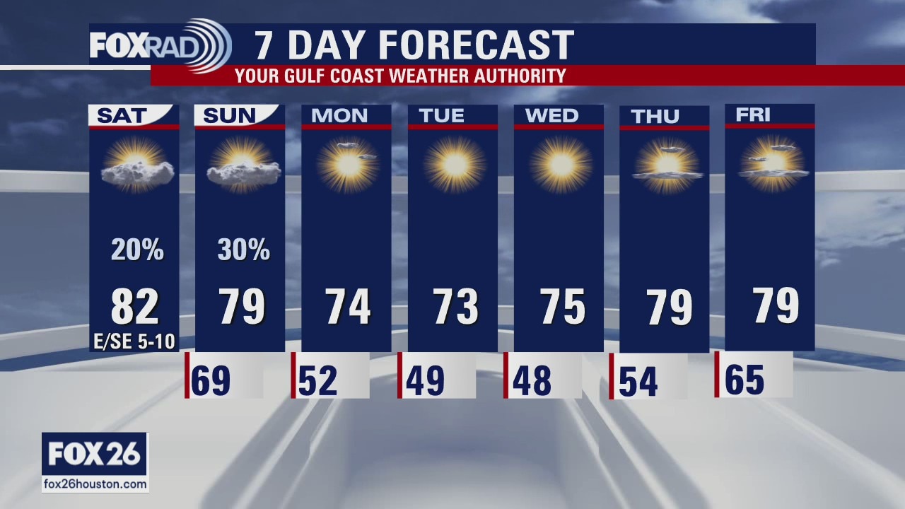
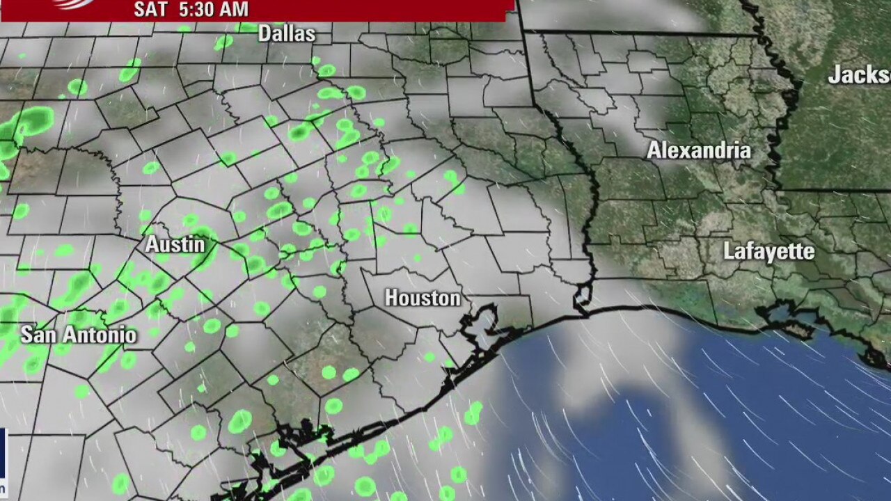
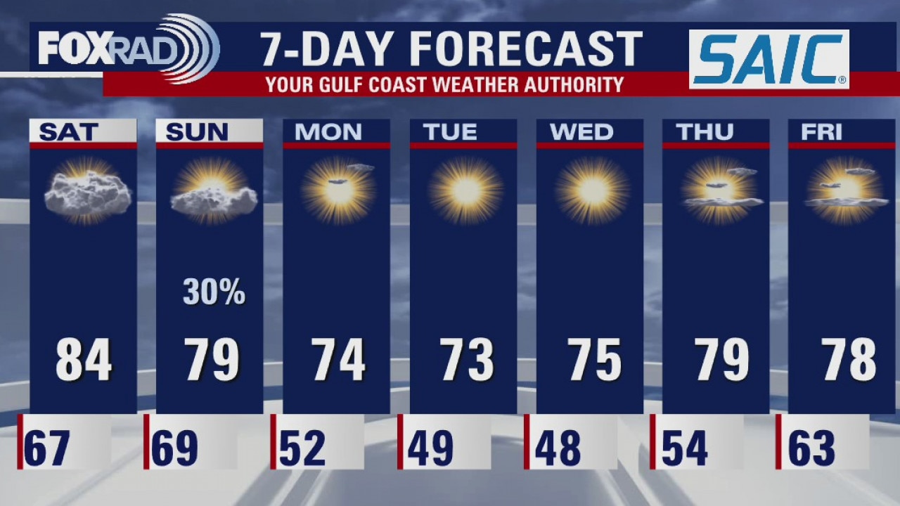
We're waiting on our next cold front to arrive on Sunday morning, but until then expect mild and muggy conditions to persist. Highs on Saturday will likely reach the low 80s. A few patches of drizzle and light rain showers look possible today as well. A better shot at rain, areawide, will arrive once the cold front does. Expect the front to move through the area some time between 3am and 7am. After the front passes, humidity levels will drop and it will (finally) feel more like Fall.
We're waiting on our next cold front to arrive on Sunday morning, but until then expect mild and muggy conditions to persist. Highs on Saturday will likely reach the low 80s. A few patches of drizzle and light rain showers look possible today as well. A better shot at rain, areawide, will arrive once the cold front does. Expect the front to move through the area some time between 3am and 7am. After the front passes, humidity levels will drop and it will (finally) feel more like Fall.
Saturday morning weather forecast
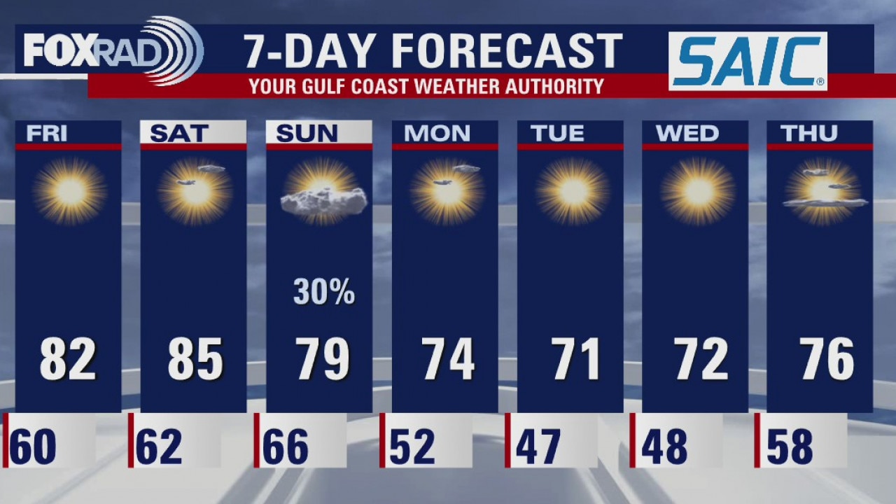
Saturday will be another warm and humid day with highs in the 80s. Look for some early patchy fog and maybe a few light showers. A cold front will arrive Sunday morning and it will drop the temps and lower the humidity for the coming week
Saturday will be another warm and humid day with highs in the 80s. Look for some early patchy fog and maybe a few light showers. A cold front will arrive Sunday morning and it will drop the temps and lower the humidity for the coming week
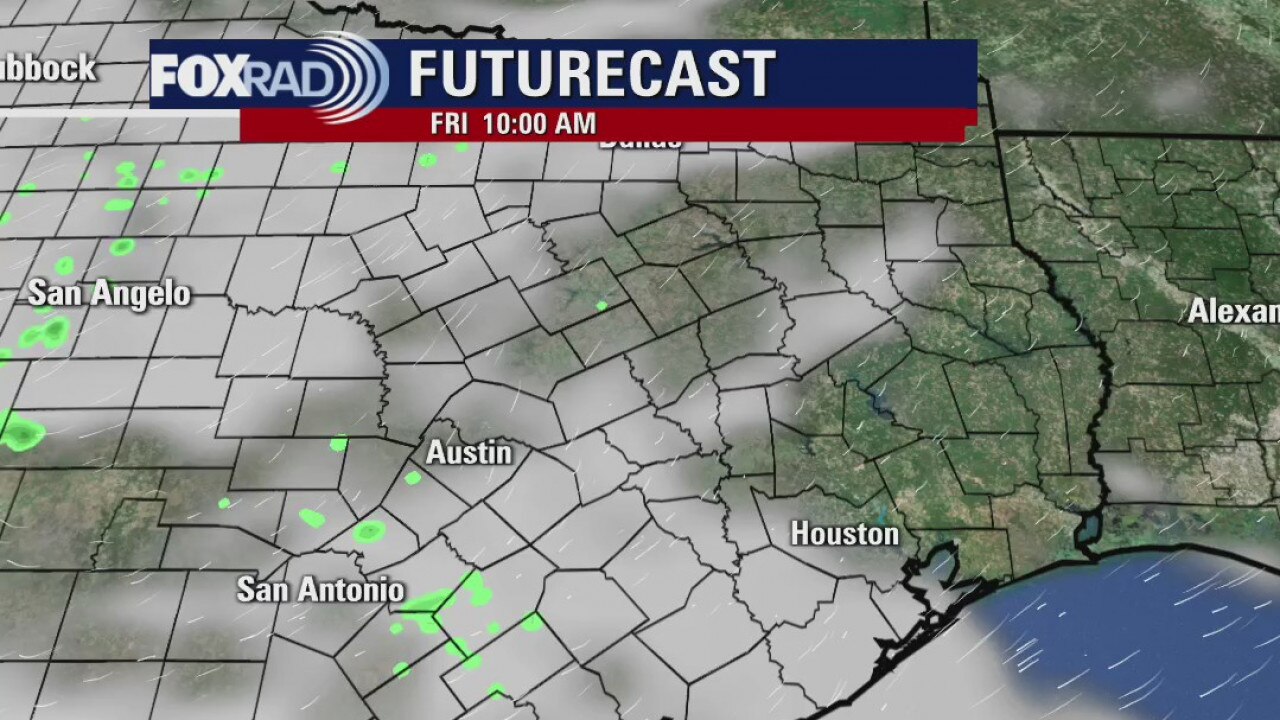
Friday evening weather forecast
Saturday will be another warm and humid day with highs in the 80s. Look for some early patchy fog and maybe a few light showers. A cold front will arrive Sunday morning and it will drop the temps and lower the humidity for the coming week. I?m ready for it.
Saturday will be another warm and humid day with highs in the 80s. Look for some early patchy fog and maybe a few light showers. A cold front will arrive Sunday morning and it will drop the temps and lower the humidity for the coming week. I?m ready for it.
Friday morning weather forecast
The humidity is moving back in and the temps are going to be in the 80s until the next cold front arrives on Sunday. Look for some patchy fog in the morning and mostly sunny skies in the afternoon. It will be cooler by Monday.
The humidity is moving back in and the temps are going to be in the 80s until the next cold front arrives on Sunday. Look for some patchy fog in the morning and mostly sunny skies in the afternoon. It will be cooler by Monday.
Thursday Evening Weather Forecast
Tropical Storm Eta is in the Atlantic and moving away. The next system is forming pretty close to where Eta started and looks to have a similar path as well. What are the odds? It?s not really a threat to Texas at this time, but we will watch it.
Tropical Storm Eta is in the Atlantic and moving away. The next system is forming pretty close to where Eta started and looks to have a similar path as well. What are the odds? It?s not really a threat to Texas at this time, but we will watch it.
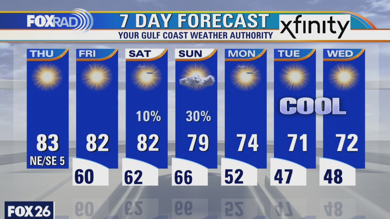
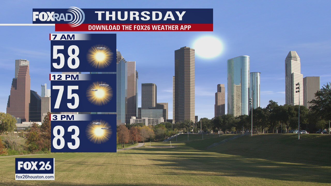
Thursday weather forecast
It was a nice, comfortable morning with lots of 50s and low 60s. Look for low 80s for the next three days followed by a cold front either late Sunday or early Monday. Cooler air will move in for much of next week and we should get those morning lows back down to the 40s for most of you.
It was a nice, comfortable morning with lots of 50s and low 60s. Look for low 80s for the next three days followed by a cold front either late Sunday or early Monday. Cooler air will move in for much of next week and we should get those morning lows back down to the 40s for most of you.
Wednesday Evening Weather Forecast
It will be cooler to start on Thur, but highs will still reach the low 80s. The weather will be rather nice with mostly sunny skies until Sunday. That?s when a front will arrive in Texas and we could see a few showers. Next week will have cooler temps with some lows dipping into the 40s.
It will be cooler to start on Thur, but highs will still reach the low 80s. The weather will be rather nice with mostly sunny skies until Sunday. That?s when a front will arrive in Texas and we could see a few showers. Next week will have cooler temps with some lows dipping into the 40s.
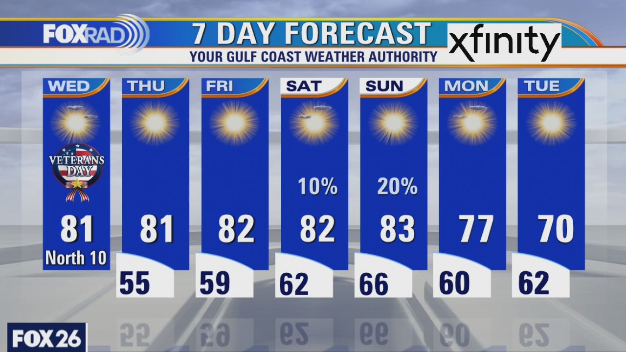
Wednesday weather forecast
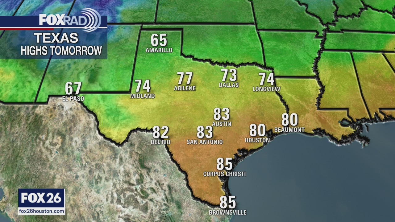
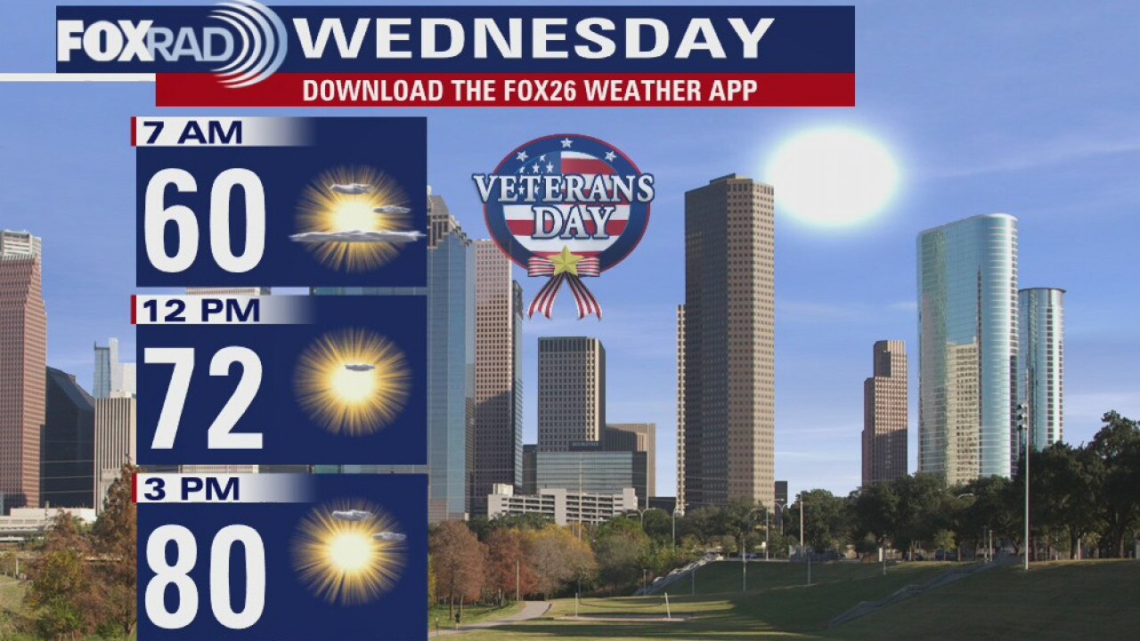
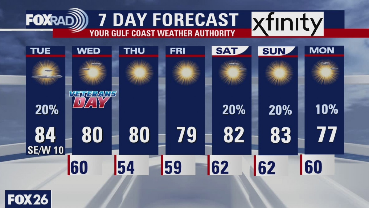
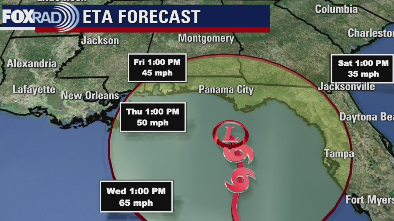
As hurricane Eta lashes the eastern Gulf, our side is looking tranquil for this Veterans Day. Look for sunshine with less humidity and pleasant highs in the low 80s. Thursday and Friday should be very nice as well with morning temperatures in the 50s. Some moisture returns this weekend before our next cold front early next week.
As hurricane Eta lashes the eastern Gulf, our side is looking tranquil for this Veterans Day. Look for sunshine with less humidity and pleasant highs in the low 80s. Thursday and Friday should be very nice as well with morning temperatures in the 50s. Some moisture returns this weekend before our next cold front early next week.
Weak front blowing through
A weak front will sweep across SE Texas this evening and it will help to dry out the air a bit and bring the temperatures down a little. It will be rather pleasant for the rest of the week and we will look for a little stronger front sometime next week.
A weak front will sweep across SE Texas this evening and it will help to dry out the air a bit and bring the temperatures down a little. It will be rather pleasant for the rest of the week and we will look for a little stronger front sometime next week.
Tuesday Evening Weather Forecast
A weak front will sweep across SE Texas this evening and it will help to dry out the air a bit and bring the temps down a little. It will be rather pleasant for the rest of the week and we will look for a little stronger front sometime next week.
A weak front will sweep across SE Texas this evening and it will help to dry out the air a bit and bring the temps down a little. It will be rather pleasant for the rest of the week and we will look for a little stronger front sometime next week.
Tuesday weather forecast
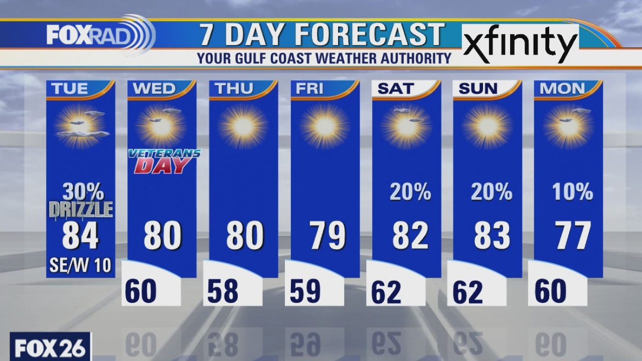
Today will be a transition day with muggy weather early on, then gradually drier air from west to east by this evening. A front will bring drier air and cooler temperatures, especially overnight. Tropical Storm Eta will bring occasional heavy rain bands to Florida as it moves very slowly toward the northern Gulf Coast - no threat to Texas.
Today will be a transition day with muggy weather early on, then gradually drier air from west to east by this evening. A front will bring drier air and cooler temperatures, especially overnight. Tropical Storm Eta will bring occasional heavy rain bands to Florida as it moves very slowly toward the northern Gulf Coast - no threat to Texas.
Tuesday weather forecast
Today will be a transition day with muggy weather early on, then gradually drier air from west to east by this evening. A front will bring drier air and cooler temperatures, especially overnight. Tropical Storm Eta will bring occasional heavy rain bands to Florida as it moves very slowly toward the northern Gulf Coast - no threat to Texas.
Today will be a transition day with muggy weather early on, then gradually drier air from west to east by this evening. A front will bring drier air and cooler temperatures, especially overnight. Tropical Storm Eta will bring occasional heavy rain bands to Florida as it moves very slowly toward the northern Gulf Coast - no threat to Texas.

Mild cold front on the way...
A cold front is moving across Texas, but it won?t have much power by the time it reaches the Houston area. Highs will generally still be in the 80s most of the week but lows will dip into the upper 50s on Thursday and Friday.
A cold front is moving across Texas, but it won?t have much power by the time it reaches the Houston area. Highs will generally still be in the 80s most of the week but lows will dip into the upper 50s on Thursday and Friday.
Monday Evening Weather Forecast
A cold front is moving across Texas, but it won?t have much power by the time it reaches the Houston area. Highs well generally still be in the 80s most of the week but lows will dip into the upper 50s on Thur and Fri. the sunshine will be nice.
A cold front is moving across Texas, but it won?t have much power by the time it reaches the Houston area. Highs well generally still be in the 80s most of the week but lows will dip into the upper 50s on Thur and Fri. the sunshine will be nice.
Monday weather forecast
As we watch Eta slam Florida with heavy rain bands, our weather will feel pretty tropical as well with high humidity and highs in the low to middle 80s with isolated showers. A weak cold front should move through late Tuesday leaving behind drier air and pleasant weather for Veterans Day through Friday.
As we watch Eta slam Florida with heavy rain bands, our weather will feel pretty tropical as well with high humidity and highs in the low to middle 80s with isolated showers. A weak cold front should move through late Tuesday leaving behind drier air and pleasant weather for Veterans Day through Friday.
Houston-area weather forecast 11/8
We are off to a foggy start, but once we can get it to dissipate the sun will dominate our sky. Expect temperatures to warm well into the 70s and low 80s today. While a stray sprinkle can't be ruled out today, most of the day will remain dry. As we head into Monday, we'll likely start off foggy and shower chances will be a bit higher until a cold front moves through on Tuesday. By Wednesday, humidity levels should be lower and that morning fog threat should be gone.
We are off to a foggy start, but once we can get it to dissipate the sun will dominate our sky. Expect temperatures to warm well into the 70s and low 80s today. While a stray sprinkle can't be ruled out today, most of the day will remain dry. As we head into Monday, we'll likely start off foggy and shower chances will be a bit higher until a cold front moves through on Tuesday. By Wednesday, humidity levels should be lower and that morning fog threat should be gone.