

Tuesday morning weather forecast
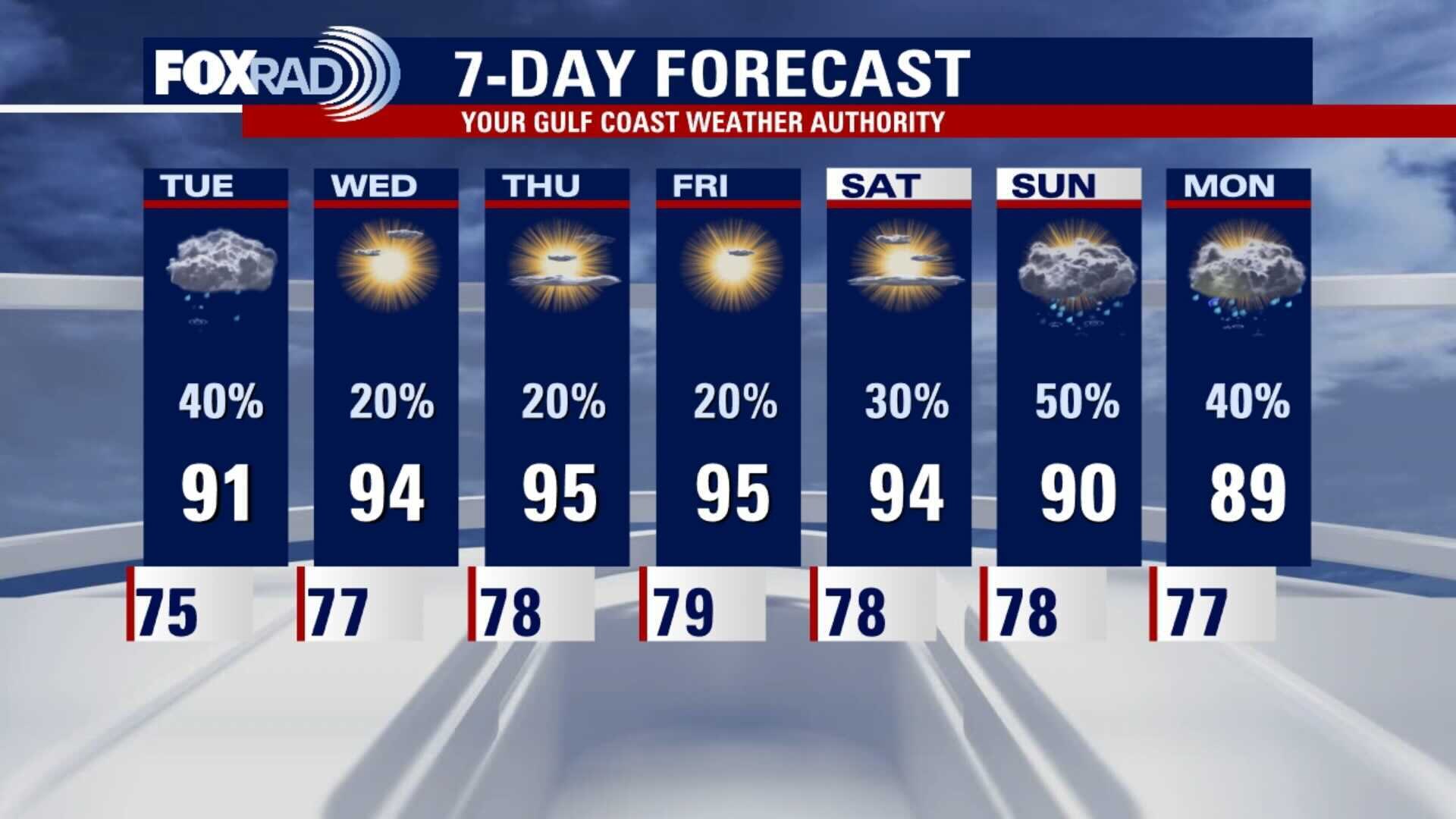
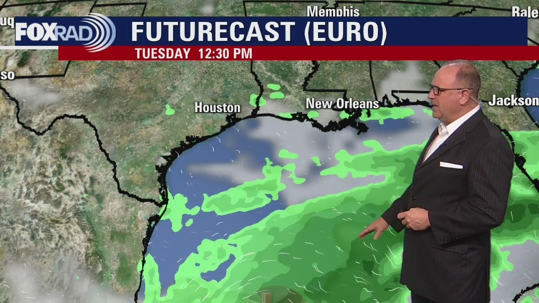
A weak front will stall along the coast by early Tuesday. Showers and some storms will become more likely as it does, but the rest of the week looks less active with more hot and humid air. Highs will be reaching back into the middle 90s.
A weak front will stall along the coast by early Tuesday. Showers and some storms will become more likely as it does, but the rest of the week looks less active with more hot and humid air. Highs will be reaching back into the middle 90s.
Monday Evening Weather Forecast
A weak front will stall along the coast by early Tuesday. Showers and some storms will become more likely as it does, but the rest of the week looks less active with more hot and humid air. Highs will be reaching back into the middle 90s.
A weak front will stall along the coast by early Tuesday. Showers and some storms will become more likely as it does, but the rest of the week looks less active with more hot and humid air. Highs will be reaching back into the middle 90s.
Monday weather forecast
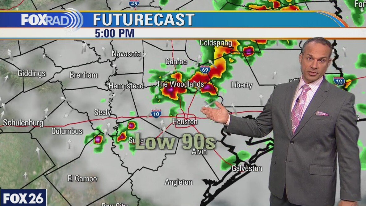
Today will be very warm and humid with a good chance for scattered storms by midday and through the evening. A rare summer cold front could bring us a line of storms late this evening followed by a very slight drop in temps. After some scattered showers and storms on Tuesday, the rest of the week looks hot and humid.
Today will be very warm and humid with a good chance for scattered storms by midday and through the evening. A rare summer cold front could bring us a line of storms late this evening followed by a very slight drop in temps. After some scattered showers and storms on Tuesday, the rest of the week looks hot and humid.

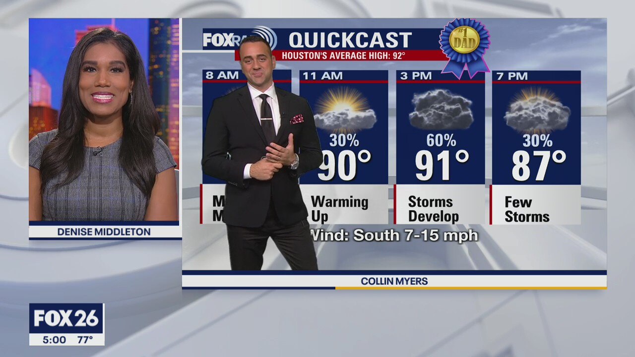
Sunday Weather Forecast-Father's Day Storms
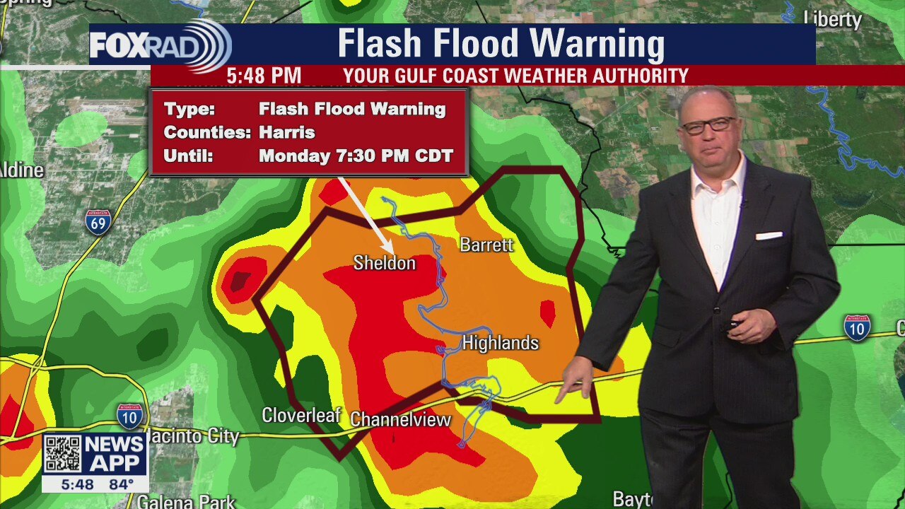
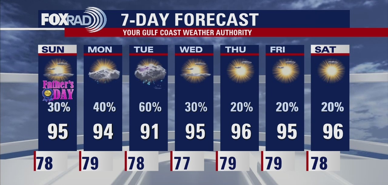
Meteorologist Collin Myers says there'll be a 60% chance of showers and thunderstorms, mainly after 12pm for your Sunday. Some could be locally heavier, especially in the afternoon with moderate rainfall and active lightning. Collin says he doesn't expect them to be severe, but some could be strong. Expect more showers and thunderstorms on and off through Monday and Tuesday. On Tuesday, a rare June "cool" front will sweep through parts of southeast Texas and could stall, leading to localized heavier storms and some localized flooding, but it is not expected to be widespread.
Meteorologist Collin Myers says there'll be a 60% chance of showers and thunderstorms, mainly after 12pm for your Sunday. Some could be locally heavier, especially in the afternoon with moderate rainfall and active lightning. Collin says he doesn't expect them to be severe, but some could be strong. Expect more showers and thunderstorms on and off through Monday and Tuesday. On Tuesday, a rare June "cool" front will sweep through parts of southeast Texas and could stall, leading to localized heavier storms and some localized flooding, but it is not expected to be widespread.

FOX 26 Sunday Morning News
Join the FOX 26 Morning Teams for the latest local, regional and national news reporting.
Join the FOX 26 Morning Teams for the latest local, regional and national news reporting.
Sunday morning forecast
Join the FOX 26 Morning Teams for the latest local, regional and national news reporting.
Join the FOX 26 Morning Teams for the latest local, regional and national news reporting.
Saturday evening weather forecast
Sunday will bring a few showers as more humidity moves onshore and early into next week. Monday and Tuesday have the best chance for scattered showers, while the rest of the week will be hot and muggy.
Sunday will bring a few showers as more humidity moves onshore and early into next week. Monday and Tuesday have the best chance for scattered showers, while the rest of the week will be hot and muggy.

Saturday morning weather forecast
Saturday looks hot and humid, but there's only a 20% for any rain since the tropical low is heading well to the east of SE Texas. Sunday will bring a few showers as more humidity moves onshore and early into next week. Monday and Tuesday have the best chance for scattered showers, while the rest of the week will be hot and muggy.
Saturday looks hot and humid, but there's only a 20% for any rain since the tropical low is heading well to the east of SE Texas. Sunday will bring a few showers as more humidity moves onshore and early into next week. Monday and Tuesday have the best chance for scattered showers, while the rest of the week will be hot and muggy.
Friday Evening Weather Forecast
Saturday looks hot and humid, but there's only a 20% for any rain since the tropical low is heading well to the east of SE Texas. Sunday will bring a few showers as more humidity moves onshore and early into next week. Monday and Tuesday have the best chance for scattered showers, while the rest of the week will be hot and muggy.
Saturday looks hot and humid, but there's only a 20% for any rain since the tropical low is heading well to the east of SE Texas. Sunday will bring a few showers as more humidity moves onshore and early into next week. Monday and Tuesday have the best chance for scattered showers, while the rest of the week will be hot and muggy.
Friday weather forecast
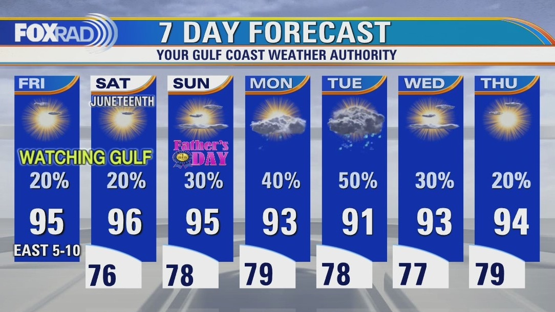
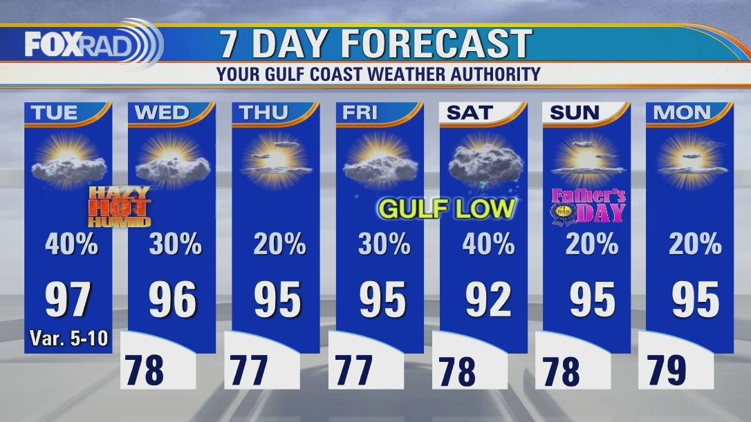
It?s looking like a typical Father?s Day weekend across Houston with warm afternoons and isolated chances for rain. Temperatures should see upper 70s for lows and mid 90s for highs. Rain returns to the forecast at the start of the work week with temperatures back in the lower 90s. The 7am update from the National Hurricane Center identifies the system in the Gulf as Potential Tropical Cyclone Three with maximum sustained winds near 35 mph. Tropical Storm Warnings have been posted along the Louisiana, Mississippi, Alabama, and Florida coasts. Impacts will be minimal for southeast Texas.
It?s looking like a typical Father?s Day weekend across Houston with warm afternoons and isolated chances for rain. Temperatures should see upper 70s for lows and mid 90s for highs. Rain returns to the forecast at the start of the work week with temperatures back in the lower 90s. The 7am update from the National Hurricane Center identifies the system in the Gulf as Potential Tropical Cyclone Three with maximum sustained winds near 35 mph. Tropical Storm Warnings have been posted along the Louisiana, Mississippi, Alabama, and Florida coasts. Impacts will be minimal for southeast Texas.
Thursday Evening Weather Forecast
The tropical low in the Gulf is expected to stay east of the Houston area, but there will still be a chance for a few scattered showers Saturday and Father's Day on Sunday. The coming week looks about normal for this time of year with hot temps and some scattered showers mainly in the afternoon hours.
The tropical low in the Gulf is expected to stay east of the Houston area, but there will still be a chance for a few scattered showers Saturday and Father's Day on Sunday. The coming week looks about normal for this time of year with hot temps and some scattered showers mainly in the afternoon hours.
Thursday weather forecast
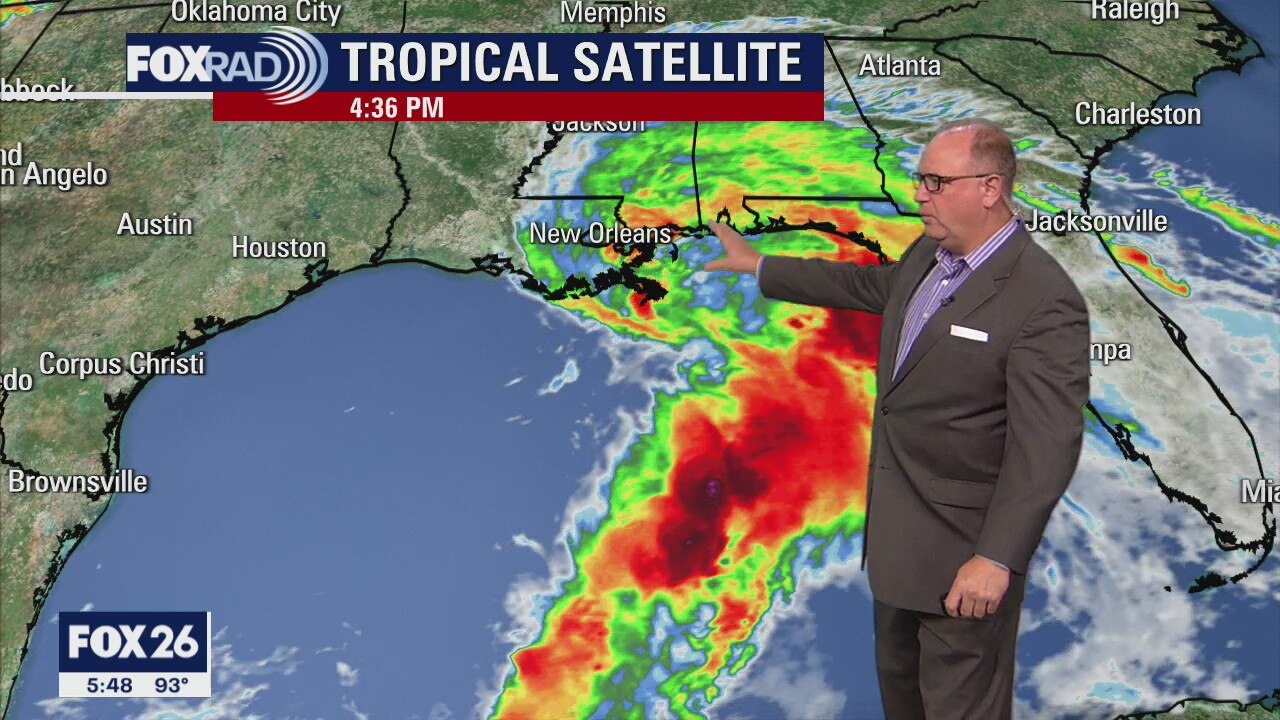
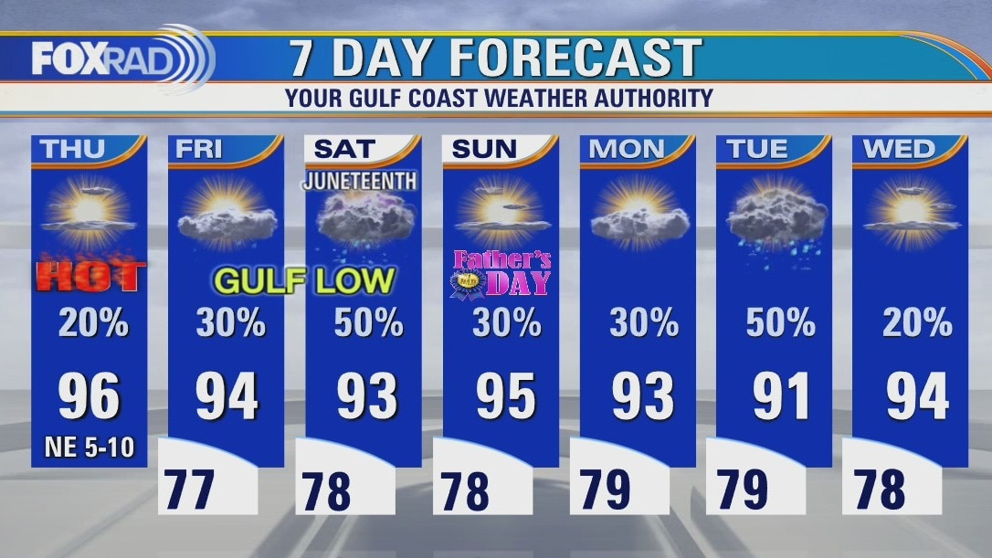
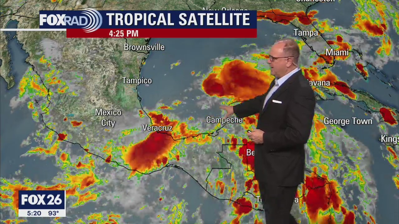
Another hot and humid day across southeast Texas for Thursday. Afternoon highs in the mid to upper 90s with heat index values in the 100s. A developing low in the Gulf will bring more clouds in the forecast for Friday and increased rain chances for the weekend. Most of Houston will see 1-2 inches or less of rain but parts of Mississippi and Alabama could see 6-12+ inches of rainfall.
Another hot and humid day across southeast Texas for Thursday. Afternoon highs in the mid to upper 90s with heat index values in the 100s. A developing low in the Gulf will bring more clouds in the forecast for Friday and increased rain chances for the weekend. Most of Houston will see 1-2 inches or less of rain but parts of Mississippi and Alabama could see 6-12+ inches of rainfall.
Thursday morning weather forecast
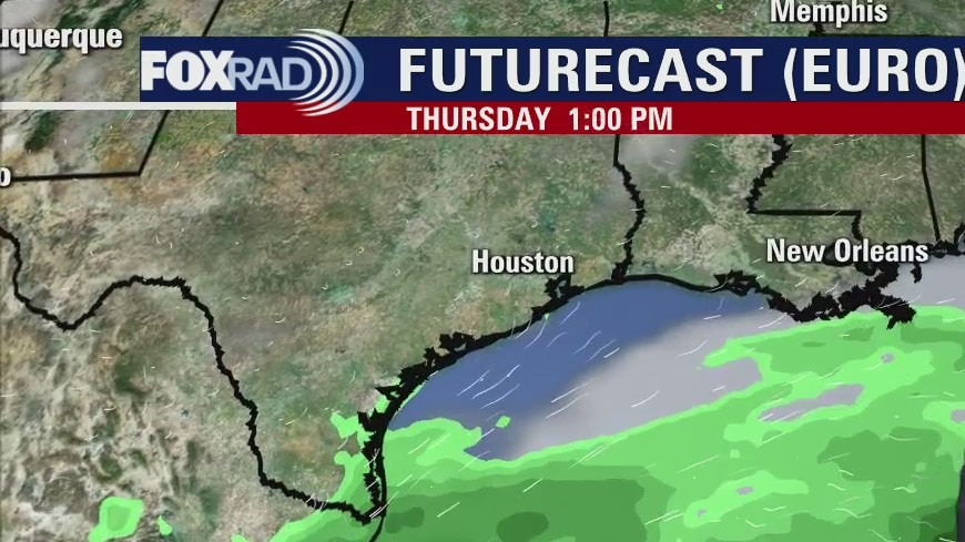
More hot and humid weather is in store for SE Texas for the rest of the week. A tropical low will likely form before the weekend, but it appears the main threats will be east of the Houston area. We can expect rain on Saturday starting after 1pm or so. We will keep an eye on the southern Gulf for any changes to the forecast.
More hot and humid weather is in store for SE Texas for the rest of the week. A tropical low will likely form before the weekend, but it appears the main threats will be east of the Houston area. We can expect rain on Saturday starting after 1pm or so. We will keep an eye on the southern Gulf for any changes to the forecast.
Wednesday Evening Forecast
More hot and humid weather is in store for SE Texas for the rest of the week. A tropical low will likely form before the weekend, but it appears the main threats will be east of the Houston area. We can expect rain on Saturday starting after 1pm or so. We will keep an eye on the southern Gulf for any changes to the forecast.
More hot and humid weather is in store for SE Texas for the rest of the week. A tropical low will likely form before the weekend, but it appears the main threats will be east of the Houston area. We can expect rain on Saturday starting after 1pm or so. We will keep an eye on the southern Gulf for any changes to the forecast.
Wednesday weather forecast
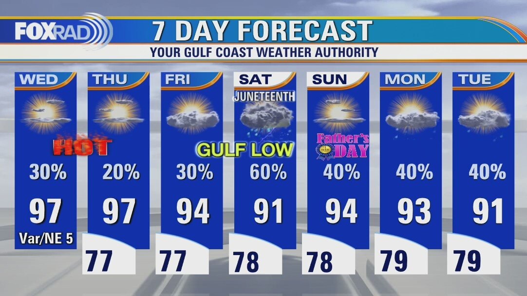
Like the last several days, we will likely reach highs in the upper 90s today with fewer storms than yesterday, but isolated early evening strong storms are possible. Otherwise, we're closely watching the Gulf, but so far the broad area of low pressure remains disorganized. It looks likely that heavy rain will move into Louisiana and Mississippi this weekend. Even if a tropical depression or storm forms, it is not expected to be a strong wind storm, so it's effects on our area are mostly increasing chances for rain late this week.
Like the last several days, we will likely reach highs in the upper 90s today with fewer storms than yesterday, but isolated early evening strong storms are possible. Otherwise, we're closely watching the Gulf, but so far the broad area of low pressure remains disorganized. It looks likely that heavy rain will move into Louisiana and Mississippi this weekend. Even if a tropical depression or storm forms, it is not expected to be a strong wind storm, so it's effects on our area are mostly increasing chances for rain late this week.
Tuesday Morning Weather Forecast
A tropical low is likely to form by Thursday and looks to be heading toward far east Texas and Louisiana. Right now the impact on SE Texas and the Houston area will be rain on Saturday. The heavy rainfall is likely in Louisiana.
A tropical low is likely to form by Thursday and looks to be heading toward far east Texas and Louisiana. Right now the impact on SE Texas and the Houston area will be rain on Saturday. The heavy rainfall is likely in Louisiana.
Tuesday Evening Weather Forecast
The weather will continue to be hot for the rest of the week so take it easy out there. A tropical low is likely to form by Thursday and looks to be heading toward far east Texas and Louisiana. Right now the impact on SE Texas and the Houston area will be rain on Saturday. The heavy rainfall is likely in Louisiana.
The weather will continue to be hot for the rest of the week so take it easy out there. A tropical low is likely to form by Thursday and looks to be heading toward far east Texas and Louisiana. Right now the impact on SE Texas and the Houston area will be rain on Saturday. The heavy rainfall is likely in Louisiana.
Tuesday weather forecast
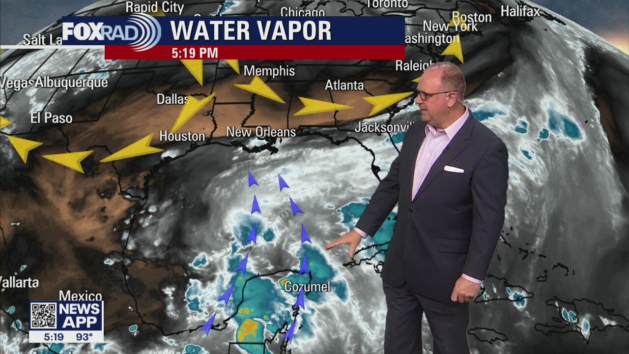
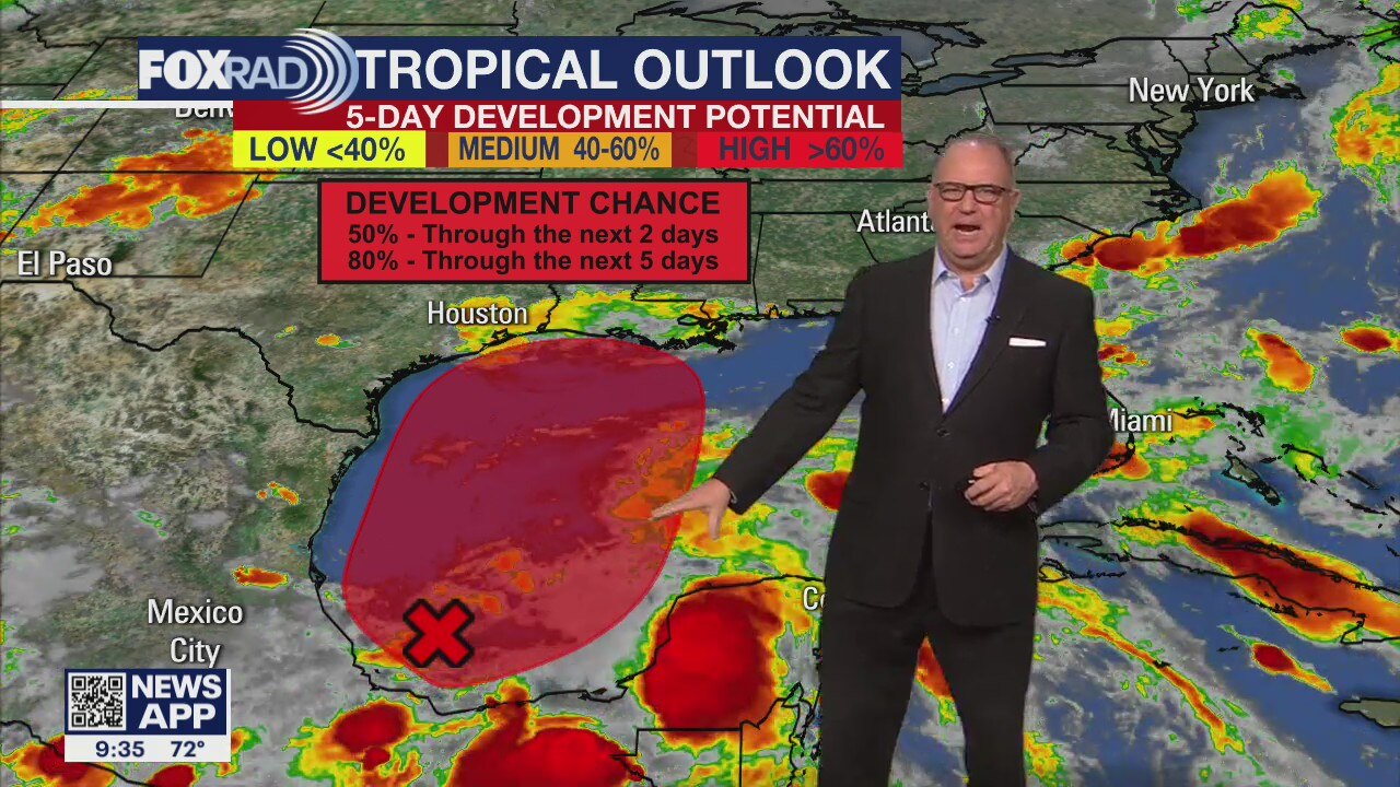
Lots to unpack in today's forecast including heat, storms and a tropical low in the southern Gulf. Watch for more upper 90s today, but with a good chance for spotty strong late afternoon storms. The rest of the week will stay hot as we watch a low forming well to our south. The disorganized stormy weather in the Bay of Campeche is not moving, but could drift northward toward the northern Gulf Coast late this week. So far, models are showing heavy rain for Louisiana and Mississippi and a brief round of rain Saturday for SE Texas. Check back daily because the track is still uncertain.
Lots to unpack in today's forecast including heat, storms and a tropical low in the southern Gulf. Watch for more upper 90s today, but with a good chance for spotty strong late afternoon storms. The rest of the week will stay hot as we watch a low forming well to our south. The disorganized stormy weather in the Bay of Campeche is not moving, but could drift northward toward the northern Gulf Coast late this week. So far, models are showing heavy rain for Louisiana and Mississippi and a brief round of rain Saturday for SE Texas. Check back daily because the track is still uncertain.
Tuesday morning weather forecast
It will be a very hot and humid week with highs in the middle 90s and heat index values in the low 100s. Rain chances will rise over the weekend as a tropical low may pass just to the east of the Houston area, but that may change. We will have a much better idea when the low actually forms in the southern Gulf and the computer models center on it. We will keep a watchful eye on it.
It will be a very hot and humid week with highs in the middle 90s and heat index values in the low 100s. Rain chances will rise over the weekend as a tropical low may pass just to the east of the Houston area, but that may change. We will have a much better idea when the low actually forms in the southern Gulf and the computer models center on it. We will keep a watchful eye on it.
Monday Evening Weather Forecast
It will be a very hot and humid week with highs in the middle 90s and heat index values in the low 100s. Rain chances will rise over the weekend as a tropical low may pass just to the east of the Houston area, but that may change. We will have a much better idea when the low actually forms in the southern Gulf and the computer models center on it. We will keep a watchful eye on it.
It will be a very hot and humid week with highs in the middle 90s and heat index values in the low 100s. Rain chances will rise over the weekend as a tropical low may pass just to the east of the Houston area, but that may change. We will have a much better idea when the low actually forms in the southern Gulf and the computer models center on it. We will keep a watchful eye on it.