

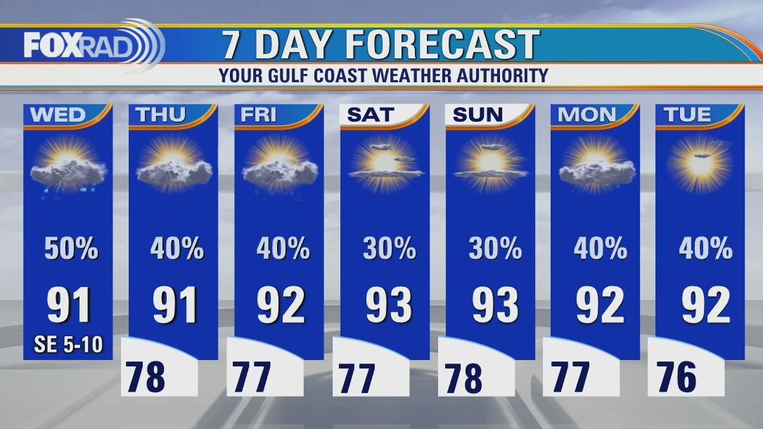
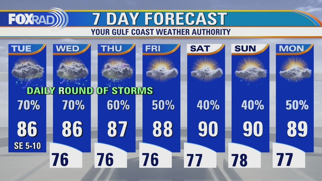
Wednesday weather forecast
Isolated morning showers, then scattered afternoon storms. Highs in the low 90s.
Isolated morning showers, then scattered afternoon storms. Highs in the low 90s.
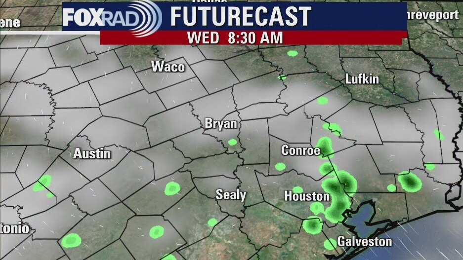
Wednesday morning weather forecast
The weather will be normal for this time of year, which is hot and humid. There will be a chance for mainly afternoon showers and thunderstorms with a few strong ones being possible. Highs will remain in the 90s and lows in the 70s well into the coming week.
The weather will be normal for this time of year, which is hot and humid. There will be a chance for mainly afternoon showers and thunderstorms with a few strong ones being possible. Highs will remain in the 90s and lows in the 70s well into the coming week.
Tuesday Evening Weather Forecast
The weather will be normal for this time of year, which is hot and humid. There will be a chance for mainly afternoon showers and thunderstorms with a few strong ones being possible. Highs will remain in the 90s and lows in the 70s well into the coming week.
The weather will be normal for this time of year, which is hot and humid. There will be a chance for mainly afternoon showers and thunderstorms with a few strong ones being possible. Highs will remain in the 90s and lows in the 70s well into the coming week.
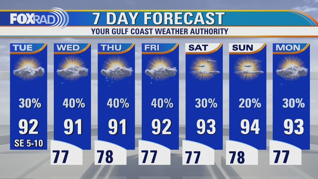
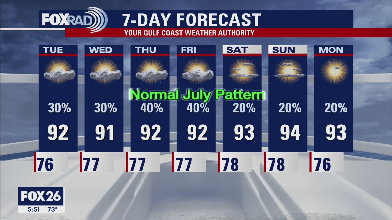
Tuesday weather forecast
Quiet this morning, then scattered late day storms with highs in the low 90s.
Quiet this morning, then scattered late day storms with highs in the low 90s.
Monday Evening Weather Forecast
The weather is getting back to normal, which means it will be hot, humid and a daily chance for showers mainly with the heating of the day. It looks a little drier by the end of the week with only a 20% chance for showers over the weekend. A little normal weather sounds nice after the soggy month we?ve just had.
The weather is getting back to normal, which means it will be hot, humid and a daily chance for showers mainly with the heating of the day. It looks a little drier by the end of the week with only a 20% chance for showers over the weekend. A little normal weather sounds nice after the soggy month we?ve just had.

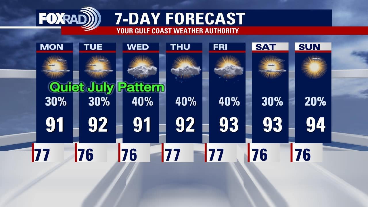
Monday weather forecast
Partly cloudy, warm and humid with spotty afternoon storms. Highs in the low 90s.
Partly cloudy, warm and humid with spotty afternoon storms. Highs in the low 90s.
Sunday weather forecast with FOX 26 Meteorologist John Dawson
Look for this week to be warm and humid with daily chances for showers or storms, a typical July in Houston. Slightly higher rain chances near the coast in the morning, then progressing inland with the sea breeze through the day. Any rain that develops should taper off in the evenings with the loss of daytime heating. High pressure builds in next weekend and should push rain chances down a bit more.
Look for this week to be warm and humid with daily chances for showers or storms, a typical July in Houston. Slightly higher rain chances near the coast in the morning, then progressing inland with the sea breeze through the day. Any rain that develops should taper off in the evenings with the loss of daytime heating. High pressure builds in next weekend and should push rain chances down a bit more.

Saturday evening weather forecast
Hot and humid, isolated showers and rinse and repeat almost every day this week. Pop showers and storms will be possible each day as this pattern continues. The tropics remain quiet for the time being, so our focus in Houston remains on the heat and humidity. Elevated rip currents today, so anyone looking to get near the water, should monitor conditions.
Hot and humid, isolated showers and rinse and repeat almost every day this week. Pop showers and storms will be possible each day as this pattern continues. The tropics remain quiet for the time being, so our focus in Houston remains on the heat and humidity. Elevated rip currents today, so anyone looking to get near the water, should monitor conditions.
Saturday morning weather forecast
The weather will be improving over the weekend, but there will still be a few minor showers here and there. A front will stall near Houston late Sunday night and that brings a little better risk for showers on Monday. It looks drier over the coming week as our weather gets back to normal. It will also be a little hotter.
The weather will be improving over the weekend, but there will still be a few minor showers here and there. A front will stall near Houston late Sunday night and that brings a little better risk for showers on Monday. It looks drier over the coming week as our weather gets back to normal. It will also be a little hotter.
Friday Evening Weather Forecast
The weather will be improving over the weekend, but there will still be a few minor showers here and there. A front will stall near Houston late Sunday night and that brings a little better risk for showers on Monday. It looks drier over the coming week as our weather gets back to normal. It will also be a little hotter.
The weather will be improving over the weekend, but there will still be a few minor showers here and there. A front will stall near Houston late Sunday night and that brings a little better risk for showers on Monday. It looks drier over the coming week as our weather gets back to normal. It will also be a little hotter.
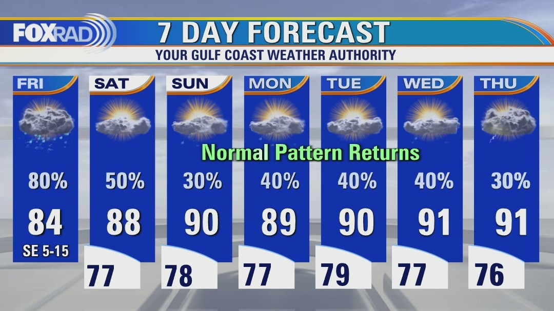
Friday weather forecast
Widespread heavy rain is occurring this morning with scattered downpours likely through the afternoon as well. Street flooding is likely today, but our weather should gradually improve tomorrow and more so by Sunday. In the meantime, an additional 3" of rain is likely today.
Widespread heavy rain is occurring this morning with scattered downpours likely through the afternoon as well. Street flooding is likely today, but our weather should gradually improve tomorrow and more so by Sunday. In the meantime, an additional 3" of rain is likely today.
Friday morning weather forecast
Heavy rainfall is likely during the day on Friday for the Houston area, but the Flash Flood Watch is posted for areas south and west of the city. Rain remains in the forecast well into the coming week so it will still be soggy for a while. There are some signs our rain chances may drop more next week, but it wouldn?t be until after Monday.
Heavy rainfall is likely during the day on Friday for the Houston area, but the Flash Flood Watch is posted for areas south and west of the city. Rain remains in the forecast well into the coming week so it will still be soggy for a while. There are some signs our rain chances may drop more next week, but it wouldn?t be until after Monday.
Thursday Evening Weather Forecast
Heavy rainfall is likely during the day on Friday for the Houston area, but the Flash Flood Watch is posted for areas south and west of the city. Rain remains in the forecast well into the coming week so it will still be soggy for a while. There are some signs our rain chances may drop more next week, but it wouldn't be until after Monday.
Heavy rainfall is likely during the day on Friday for the Houston area, but the Flash Flood Watch is posted for areas south and west of the city. Rain remains in the forecast well into the coming week so it will still be soggy for a while. There are some signs our rain chances may drop more next week, but it wouldn't be until after Monday.
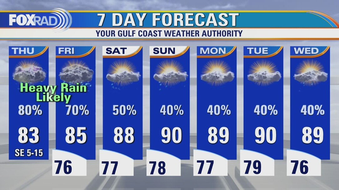
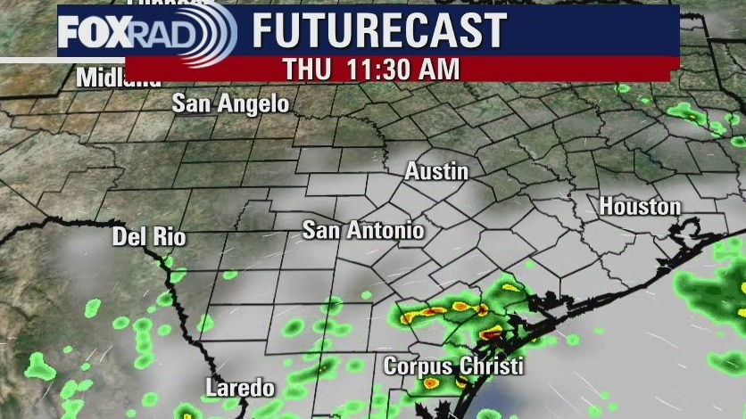
Thursday weather forecast
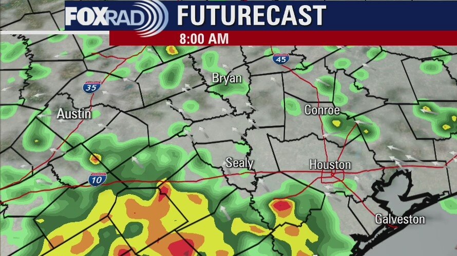
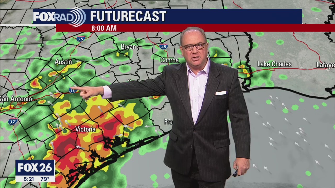
Stay alert today and tomorrow for the potential for more heavy downpours. The greatest risk is south of Houston, but a few hefty storms could set up closer to the city at times. We may see a bit of a break this weekend, especially Sunday. Flash flood watches are in effect for coastal counties until 7 p.m. Friday.
Stay alert today and tomorrow for the potential for more heavy downpours. The greatest risk is south of Houston, but a few hefty storms could set up closer to the city at times. We may see a bit of a break this weekend, especially Sunday. Flash flood watches are in effect for coastal counties until 7 p.m. Friday.
Thursday morning weather forecast
Heavy rainfall is expected along the coastal areas of SE Texas through Friday morning. A Flash Flood Watch is posted for Galveston, Brazoria, Matagorda, and Jackson Counties until 7am Friday. The inland areas can expect showers too, but probably not as heavy as on the coast. Rain chances will drop a little toward the beginning of next week.
Heavy rainfall is expected along the coastal areas of SE Texas through Friday morning. A Flash Flood Watch is posted for Galveston, Brazoria, Matagorda, and Jackson Counties until 7am Friday. The inland areas can expect showers too, but probably not as heavy as on the coast. Rain chances will drop a little toward the beginning of next week.
Wednesday Evening Weather Forecast
Heavy rainfall is expected along the coastal areas of SE Texas through Friday morning. A Flash Flood Watch is posted for Galveston, Brazoria, Matagorda, and Jackson Counties until 7am Friday. The inland areas can expect showers too, but probably not as heavy as on the coast. Rain chances will drop a little toward the beginning of next week.
Heavy rainfall is expected along the coastal areas of SE Texas through Friday morning. A Flash Flood Watch is posted for Galveston, Brazoria, Matagorda, and Jackson Counties until 7am Friday. The inland areas can expect showers too, but probably not as heavy as on the coast. Rain chances will drop a little toward the beginning of next week.

Weather remains wet in greater Houston area
More wet times ahead as we continue to deal with a weather pattern that really won't be changing until Friday. A Flash Flood Watch has been extended to include Brazoria and Galveston counties, as well as the Bolivar Peninsula, until Friday morning. While the heaviest rain is expected along the coast, rounds of rain will also spread farther north during the day today and tomorrow. While it won't be raining the entire time, expect periods of rain throughout the day. Due to the rain and clouds, highs will be kept at bay, warming only into the mid 80s this afternoon.
More wet times ahead as we continue to deal with a weather pattern that really won't be changing until Friday. A Flash Flood Watch has been extended to include Brazoria and Galveston counties, as well as the Bolivar Peninsula, until Friday morning. While the heaviest rain is expected along the coast, rounds of rain will also spread farther north during the day today and tomorrow. While it won't be raining the entire time, expect periods of rain throughout the day. Due to the rain and clouds, highs will be kept at bay, warming only into the mid 80s this afternoon.

Wednesday morning weather forecast
The weather pattern for SE Texas will remain the same with daily chances for rain, but it won't rain all day long. The weekend will bring a slightly less risk for showers, but not by much and the beginning of next week looks about the same.
The weather pattern for SE Texas will remain the same with daily chances for rain, but it won't rain all day long. The weekend will bring a slightly less risk for showers, but not by much and the beginning of next week looks about the same.
Tuesday Evening Weather Forecast
The weather pattern for SE Texas will remain the same with daily chances for rain, but it won't rain all day long. The weekend will bring a slightly less risk for showers, but not by much and the beginning of next week looks about the same.
The weather pattern for SE Texas will remain the same with daily chances for rain, but it won't rain all day long. The weekend will bring a slightly less risk for showers, but not by much and the beginning of next week looks about the same.
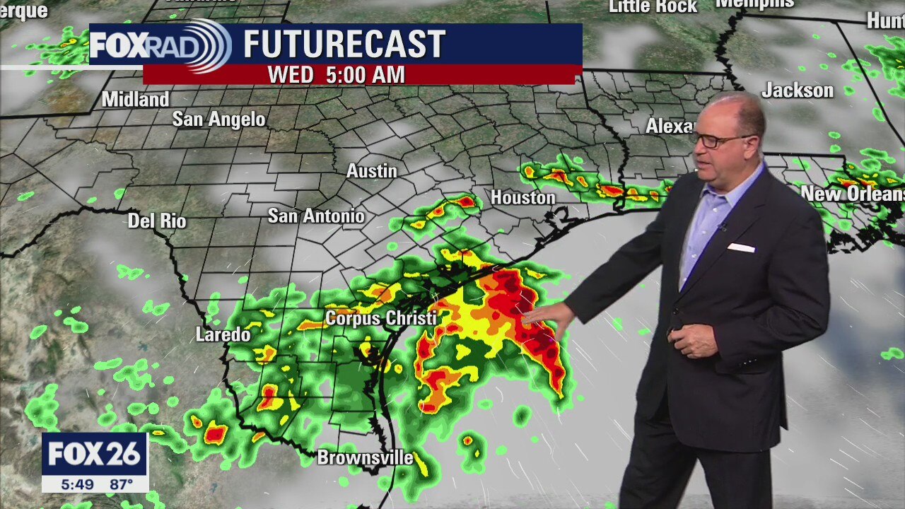
Tuesday weather forecast
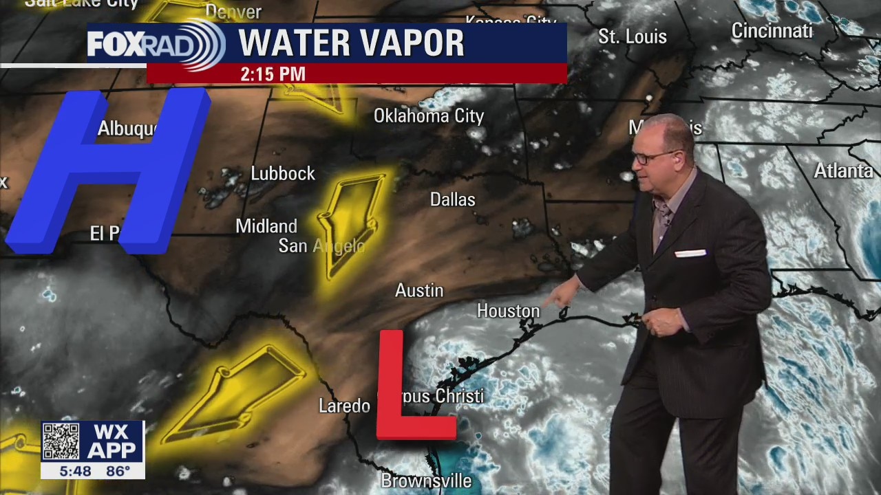
More than 4" of rain has already fallen early today in Matagorda and Brazoria Counties and rain looks likely closer to Houston by midday. Expect a daily round of storms all the way through Friday and possibly beyond. Individual storms could drop more than 2" of rain at a time. One good effect is that high temperatures will be held several degrees below normal.
More than 4" of rain has already fallen early today in Matagorda and Brazoria Counties and rain looks likely closer to Houston by midday. Expect a daily round of storms all the way through Friday and possibly beyond. Individual storms could drop more than 2" of rain at a time. One good effect is that high temperatures will be held several degrees below normal.