

Friday Evening Weather Forecast
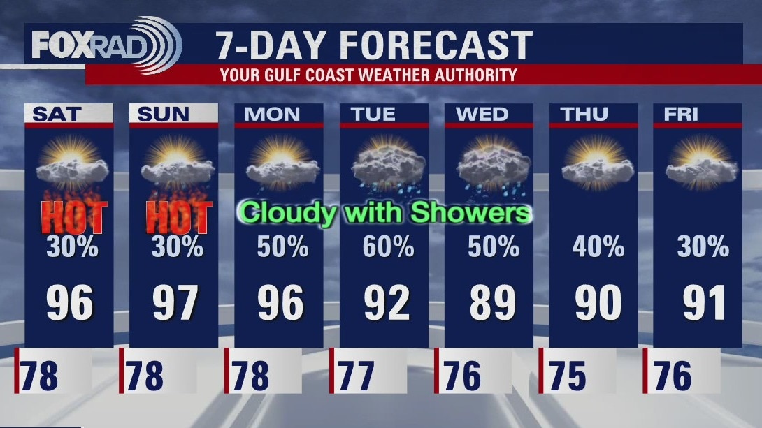
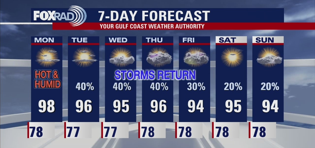
Get ready for a steamy weekend around Houston. Isolated afternoon showers and storms but most of the time it will just be summertime hot. The pattern changes on Monday as a front approaches and stalls across the area. Look for more clouds and showers for most of next week.
Get ready for a steamy weekend around Houston. Isolated afternoon showers and storms but most of the time it will just be summertime hot. The pattern changes on Monday as a front approaches and stalls across the area. Look for more clouds and showers for most of next week.
Steamy weather continues
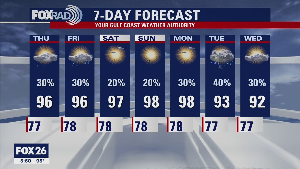
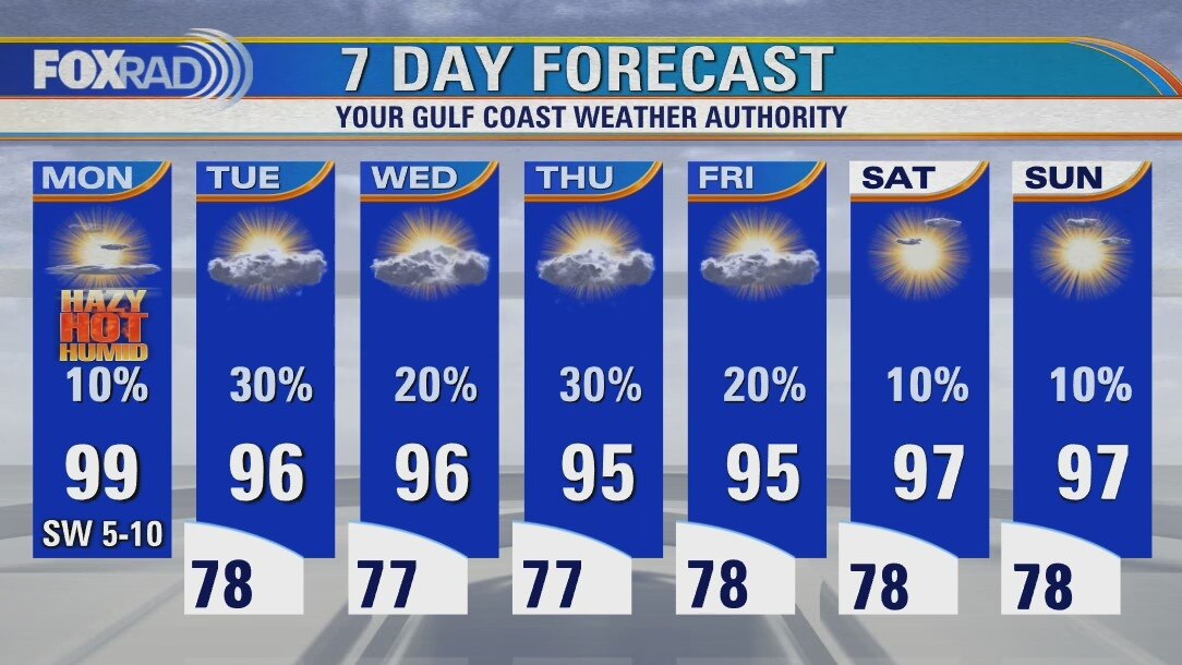
Our steamy weather pattern will continue today and this weekend. Expect highs in the mid-90s, but with a heat index near 105 and a few scattered storms possible. Next week looks a bit interesting with a summer front sliding in which should bring showers and dial down the heat.
Our steamy weather pattern will continue today and this weekend. Expect highs in the mid-90s, but with a heat index near 105 and a few scattered storms possible. Next week looks a bit interesting with a summer front sliding in which should bring showers and dial down the heat.
Friday morning weather forecast
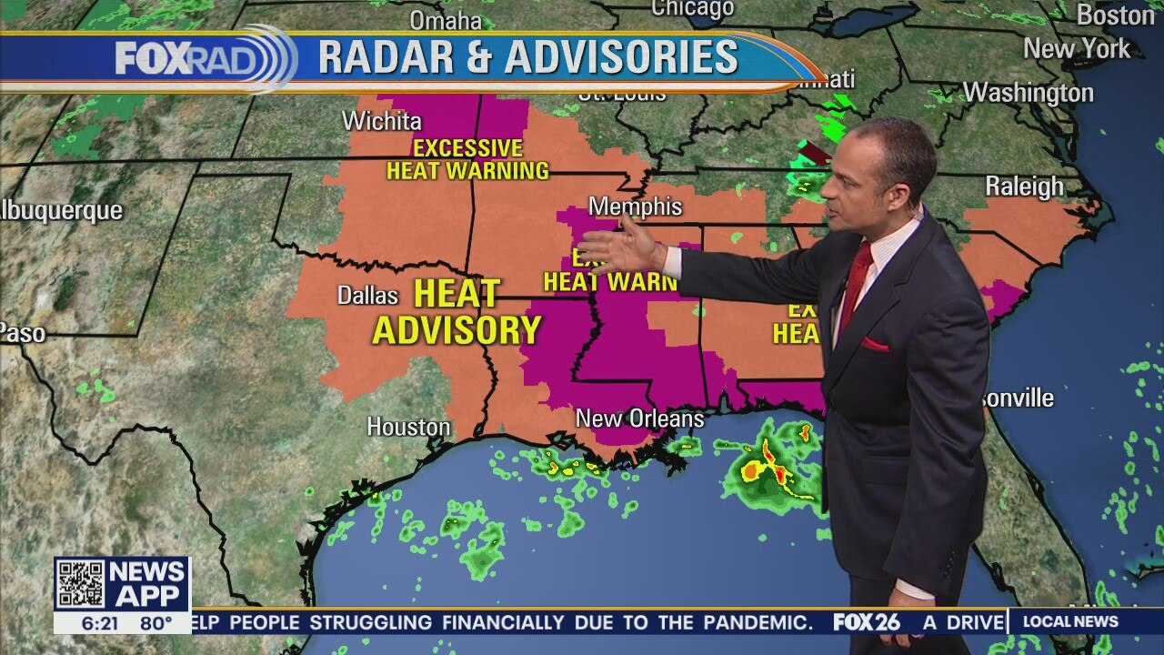
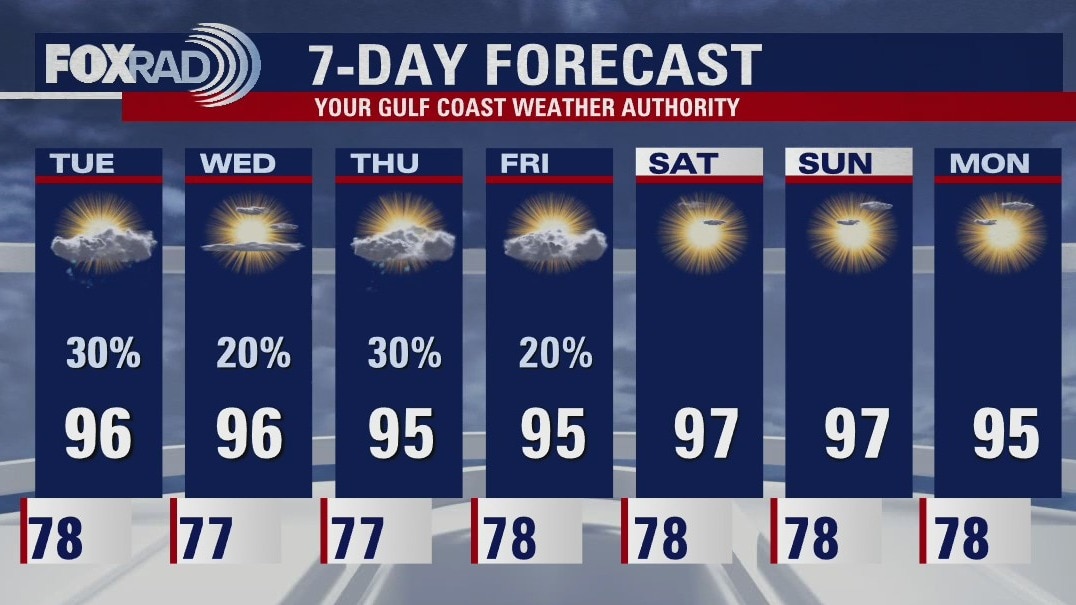
The typical July weather will continue through the weekend. Expect isolated to scattered showers/storms Friday with heat index values peaking around 103-108 in the afternoon. Look for more hot and humid conditions Saturday and Sunday with less chances for those afternoon downpours. Rain chances increase next week as a August cold front enters and stalls across Southeast Texas.
The typical July weather will continue through the weekend. Expect isolated to scattered showers/storms Friday with heat index values peaking around 103-108 in the afternoon. Look for more hot and humid conditions Saturday and Sunday with less chances for those afternoon downpours. Rain chances increase next week as a August cold front enters and stalls across Southeast Texas.
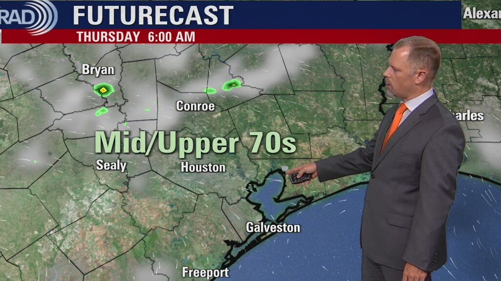
Thursday Evening Weather Forecast
The typical July weather will continue through the weekend. Expect isolated to scattered showers/storms Friday with heat index values peaking around 103-108 in the afternoon. Look for more hot and humid conditions Saturday and Sunday with less chances for those afternoon downpours. Rain chances increase next week as a August cold front enters and stalls across Southeast Texas.
The typical July weather will continue through the weekend. Expect isolated to scattered showers/storms Friday with heat index values peaking around 103-108 in the afternoon. Look for more hot and humid conditions Saturday and Sunday with less chances for those afternoon downpours. Rain chances increase next week as a August cold front enters and stalls across Southeast Texas.
Thursday morning weather forecast
The July heat is here and you should expect it to stay around for a while. There will be a few afternoon showers but don't look for much of a break from the heat index values running 105-110. Most of us won't get any rainfall, it's looking like a very typical summer pattern. Maybe a few more showers around the area on Tuesday.
The July heat is here and you should expect it to stay around for a while. There will be a few afternoon showers but don't look for much of a break from the heat index values running 105-110. Most of us won't get any rainfall, it's looking like a very typical summer pattern. Maybe a few more showers around the area on Tuesday.
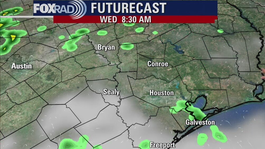
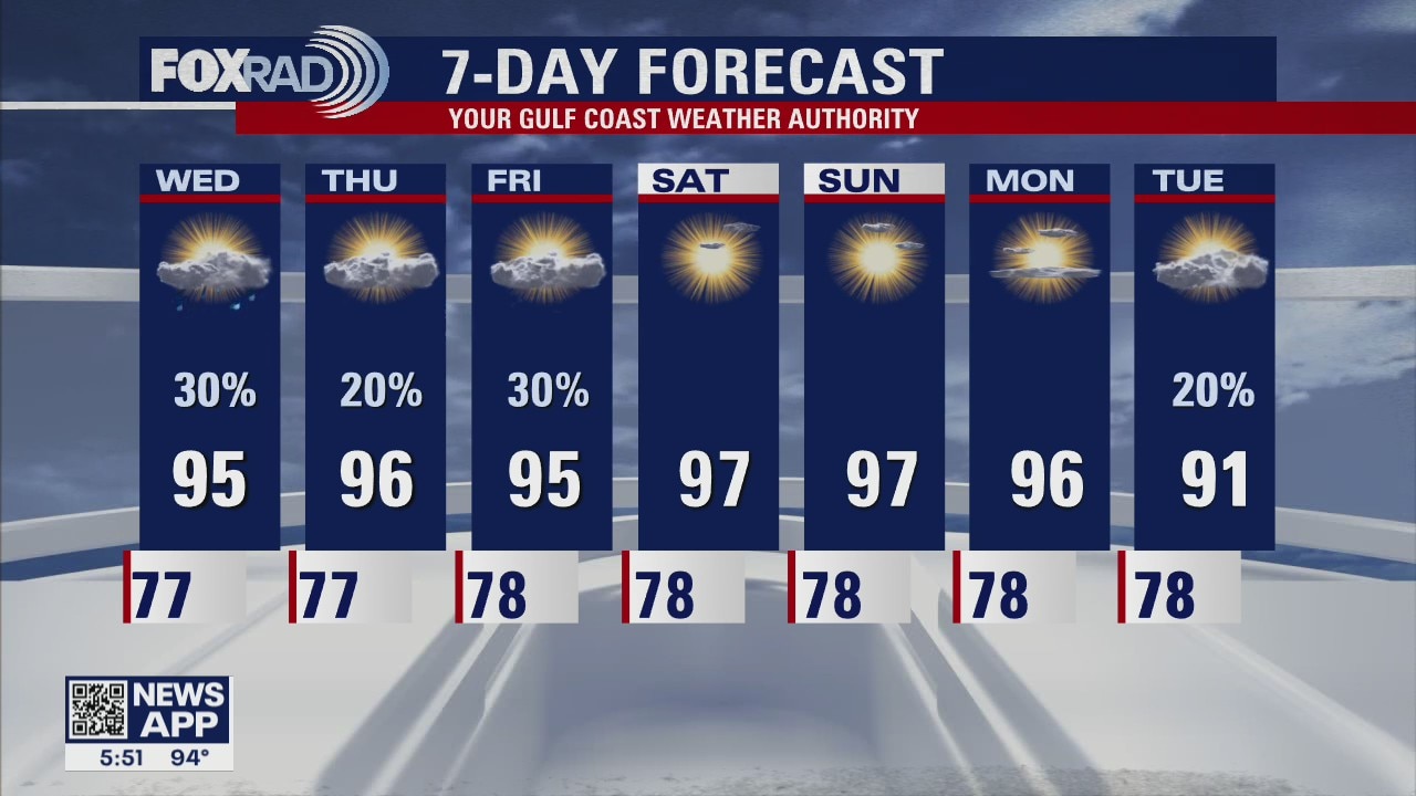
Wednesday Evening Weather Forecast
The July heat is here and you should expect it to stay around for a while. There will be a few afternoon showers but don't look for much of break from the heat index values running 105-110. Most of us won't get any rainfall, it's looking like a very typical summer pattern. Maybe a few more showers around the area on Tuesday.
The July heat is here and you should expect it to stay around for a while. There will be a few afternoon showers but don't look for much of break from the heat index values running 105-110. Most of us won't get any rainfall, it's looking like a very typical summer pattern. Maybe a few more showers around the area on Tuesday.
Wednesday morning weather forecast
It will be hot for the next few days, but a few showers may slip into SE Texas with the daytime heating. Most of us won't get any rainfall, and those who do will only have a brief break from the heat. It's all rather typical for the summer.
It will be hot for the next few days, but a few showers may slip into SE Texas with the daytime heating. Most of us won't get any rainfall, and those who do will only have a brief break from the heat. It's all rather typical for the summer.
Tuesday Evening Weather Forecast
It will be hot for the next few days, but a few showers may slip into SE Texas with the daytime heating. Most of us won't get any rainfall, and those who do will only have a brief break from the heat. It's all rather typical for the summer.
It will be hot for the next few days, but a few showers may slip into SE Texas with the daytime heating. Most of us won't get any rainfall, and those who do will only have a brief break from the heat. It's all rather typical for the summer.

Tuesday weather forecast
We're back in more of a normal summer mode here in SE Texas with pop-up afternoon storms along with hot and humid temps. Yesterday was the warmest day of the summer so far with a high of 99� measured at Bush IAH. We should be slightly less hot with scattered storms.
We're back in more of a normal summer mode here in SE Texas with pop-up afternoon storms along with hot and humid temps. Yesterday was the warmest day of the summer so far with a high of 99� measured at Bush IAH. We should be slightly less hot with scattered storms.
Tuesday morning weather forecast
Temps will remain a bit above normal over the next few days and there will be a slight chance for a few showers mainly during the afternoon hours. The weekend looks a little hotter and with less risk for rain. It all feels like summer to me.
Temps will remain a bit above normal over the next few days and there will be a slight chance for a few showers mainly during the afternoon hours. The weekend looks a little hotter and with less risk for rain. It all feels like summer to me.

Monday Evening Weather Forecast
Temps will remain a bit above normal over the next few days and there will be a slight chance for a few showers mainly during the afternoon hours. The weekend looks a little hotter and with less risk for rain. It all feels like summer to me.
Temps will remain a bit above normal over the next few days and there will be a slight chance for a few showers mainly during the afternoon hours. The weekend looks a little hotter and with less risk for rain. It all feels like summer to me.
Monday weather forecast
Plan for hot sunshine today with highs getting close to 100...fantastic. A chance for isolated showers and storms returns tomorrow and we should see off and on showers along with hot and humid weather for the rest of the week. The tropics remain quiet.
Plan for hot sunshine today with highs getting close to 100...fantastic. A chance for isolated showers and storms returns tomorrow and we should see off and on showers along with hot and humid weather for the rest of the week. The tropics remain quiet.
Sunday evening weather forecast with Meteorologist Collin Myers
The hot and humid weather continues for one day before the storms make a comeback.
The hot and humid weather continues for one day before the storms make a comeback.

Houston-area weather forecast: July 25th
We're off to a mild start this morning with mostly clear skies. Those clear skies, in fact, allowing us to cool off a bit more compared to yesterday. Forecast today, however, remains hot with highs likely reaching the upper 90s. A couple spots may even hit 100?. Rain chances remain less than 10% until Tuesday when the area of high pressure, responsible for our heat, will slide off to the west and we'll return to a muggier weather pattern.
We're off to a mild start this morning with mostly clear skies. Those clear skies, in fact, allowing us to cool off a bit more compared to yesterday. Forecast today, however, remains hot with highs likely reaching the upper 90s. A couple spots may even hit 100?. Rain chances remain less than 10% until Tuesday when the area of high pressure, responsible for our heat, will slide off to the west and we'll return to a muggier weather pattern.

Saturday evening weather with Meteorologist Collin Myers
Hot and humid through Tuesday and storms returning late Tuesday through Thursday.
Hot and humid through Tuesday and storms returning late Tuesday through Thursday.
Saturday morning weather forecast
The weekend will be a hot one with highs in the upper 90s and heat index values pushing 109 degrees. The coming week looks only a little cooler and each day will have a slight chance for some thundershowers. Things are getting back to normal. We may miss the rain and how it kept temps cooler for this time of year.
The weekend will be a hot one with highs in the upper 90s and heat index values pushing 109 degrees. The coming week looks only a little cooler and each day will have a slight chance for some thundershowers. Things are getting back to normal. We may miss the rain and how it kept temps cooler for this time of year.

Friday evening weather forecast
The weekend will be a hot one with highs in the upper 90s and heat index values pushing 109 degrees. The coming week looks only a little cooler and each day will have a slight chance for some thundershowers. Things are getting back to normal. We may miss the rain and how it kept temps cooler for this time of year.
The weekend will be a hot one with highs in the upper 90s and heat index values pushing 109 degrees. The coming week looks only a little cooler and each day will have a slight chance for some thundershowers. Things are getting back to normal. We may miss the rain and how it kept temps cooler for this time of year.
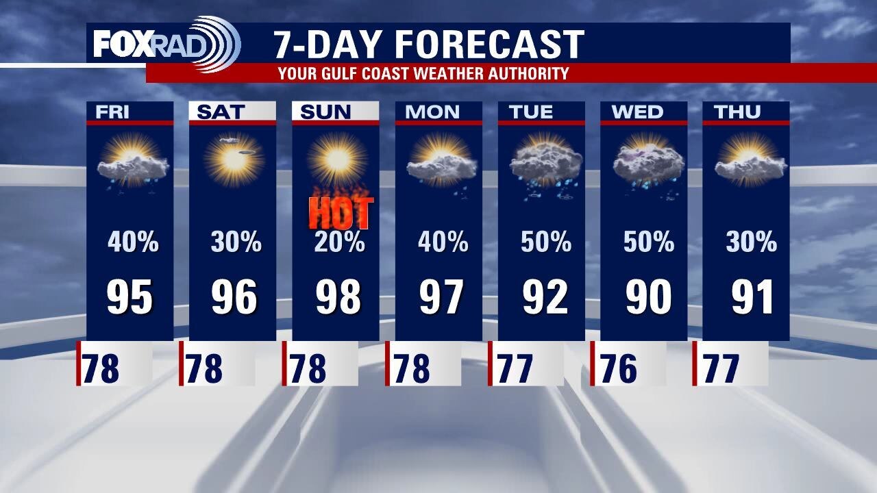
Friday weather forecast
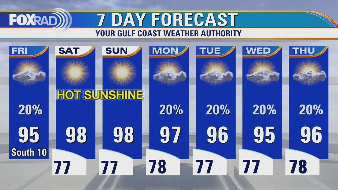
Less rain and more heat - that's the overall theme of our forecast heading into the weekend. Look for highs in the mid-90s today and likely the upper 90s this weekend. It doesn't look like much relief is coming next week either. At least the tropics are nice and quiet for now.
Less rain and more heat - that's the overall theme of our forecast heading into the weekend. Look for highs in the mid-90s today and likely the upper 90s this weekend. It doesn't look like much relief is coming next week either. At least the tropics are nice and quiet for now.
Friday morning weather forecast
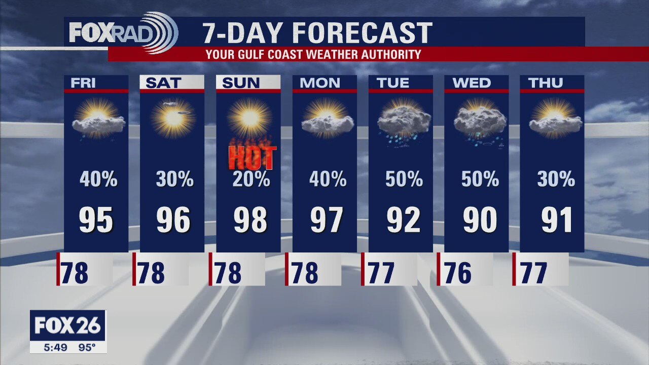
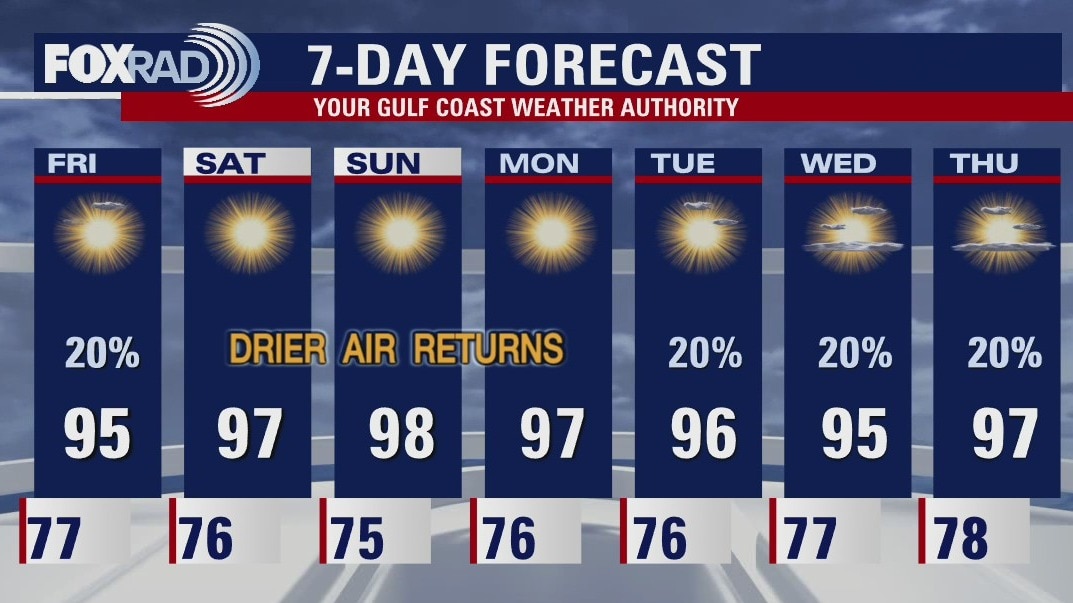
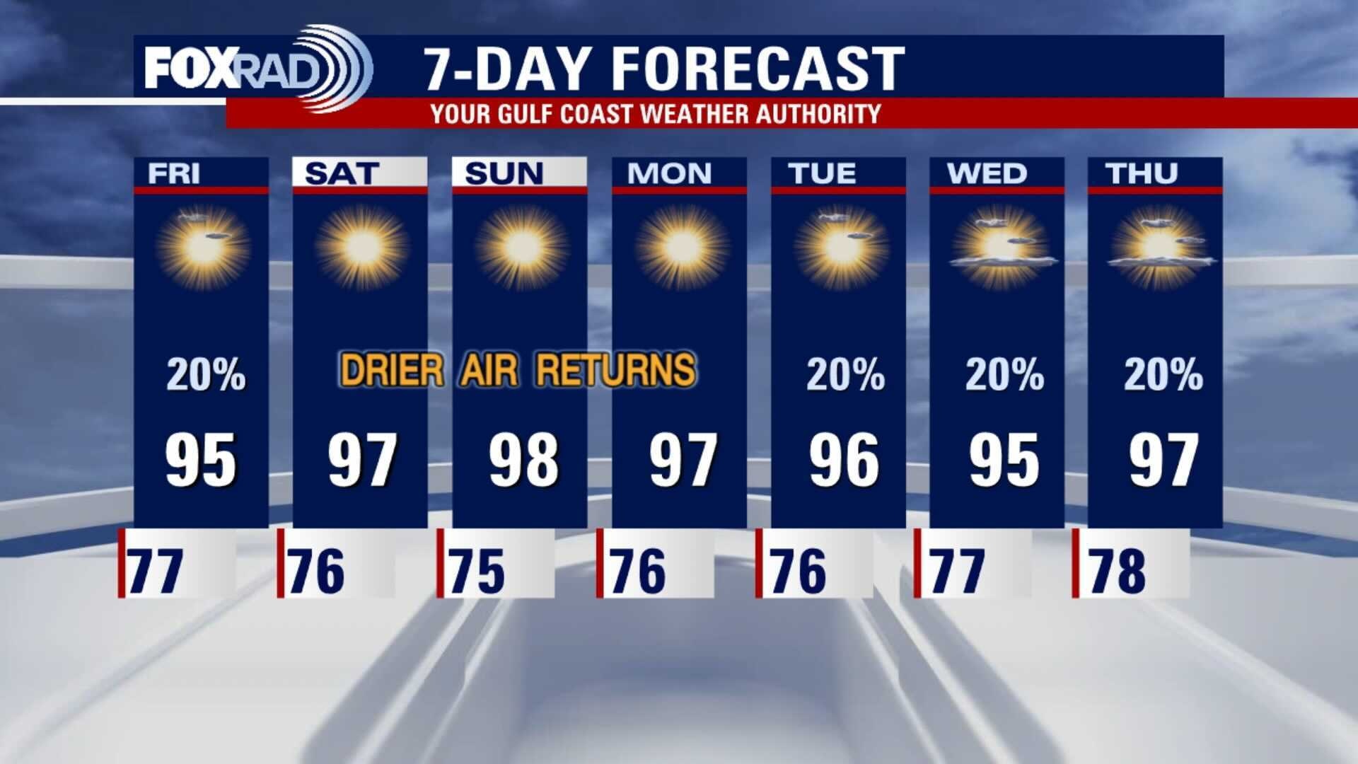
High pressure will move closer to the Houston area on Friday, bringing less rain and more heat. Slightly drier air will help to push temps into the mid to upper 90s over the weekend. The coming week looks hot and humid, but with less rain.
High pressure will move closer to the Houston area on Friday, bringing less rain and more heat. Slightly drier air will help to push temps into the mid to upper 90s over the weekend. The coming week looks hot and humid, but with less rain.
Thursday evening weather forecast
High pressure will move closer to the Houston area on Friday, bringing less rain and more heat. Slightly drier air will help to push temps into the mid to upper 90s over the weekend. The coming week looks hot and humid, but with less rain.
High pressure will move closer to the Houston area on Friday, bringing less rain and more heat. Slightly drier air will help to push temps into the mid to upper 90s over the weekend. The coming week looks hot and humid, but with less rain.