

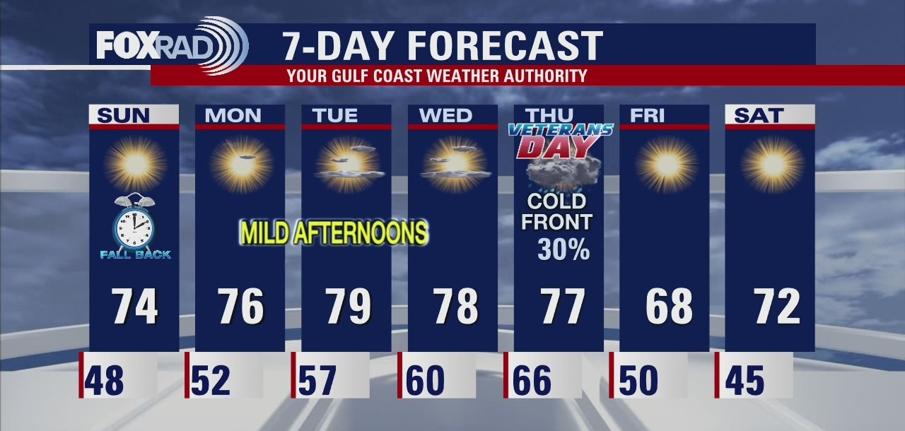
Saturday leading into Sunday weather forecast
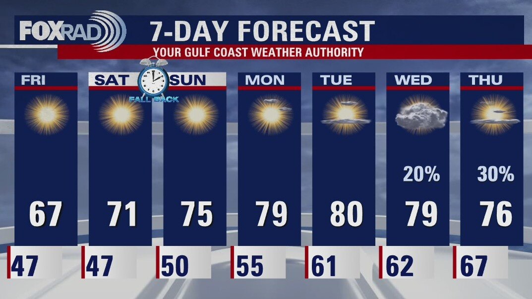
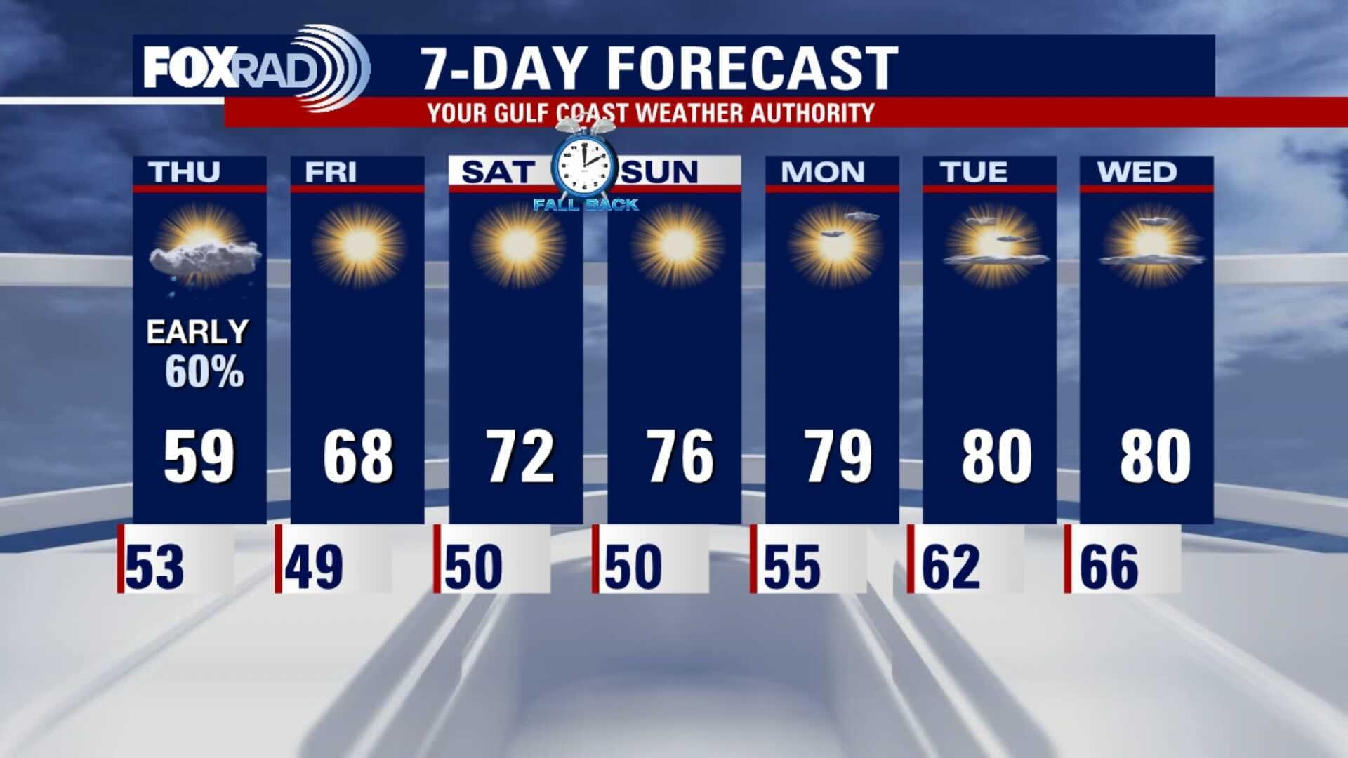
Clocks are falling back and temperatures are crawling up. Watch for mornings to warm slowly as we start the work week. No rain in the forecast for Houston until the next front on Thursday. Southeast Texas should see another fine Fall weekend after the front clears
Clocks are falling back and temperatures are crawling up. Watch for mornings to warm slowly as we start the work week. No rain in the forecast for Houston until the next front on Thursday. Southeast Texas should see another fine Fall weekend after the front clears
Saturday Morning Forecast with Meteorologist Lena Maria Arango
Sunny, dry weather prevails through the middle of next week. After a seasonably cool weekend, we'll see a temporary warming trend at the start of the work week. Our next front looks to arrive on Thursday, bringing the return of cooler, fall like weather for the weekend.
Sunny, dry weather prevails through the middle of next week. After a seasonably cool weekend, we'll see a temporary warming trend at the start of the work week. Our next front looks to arrive on Thursday, bringing the return of cooler, fall like weather for the weekend.

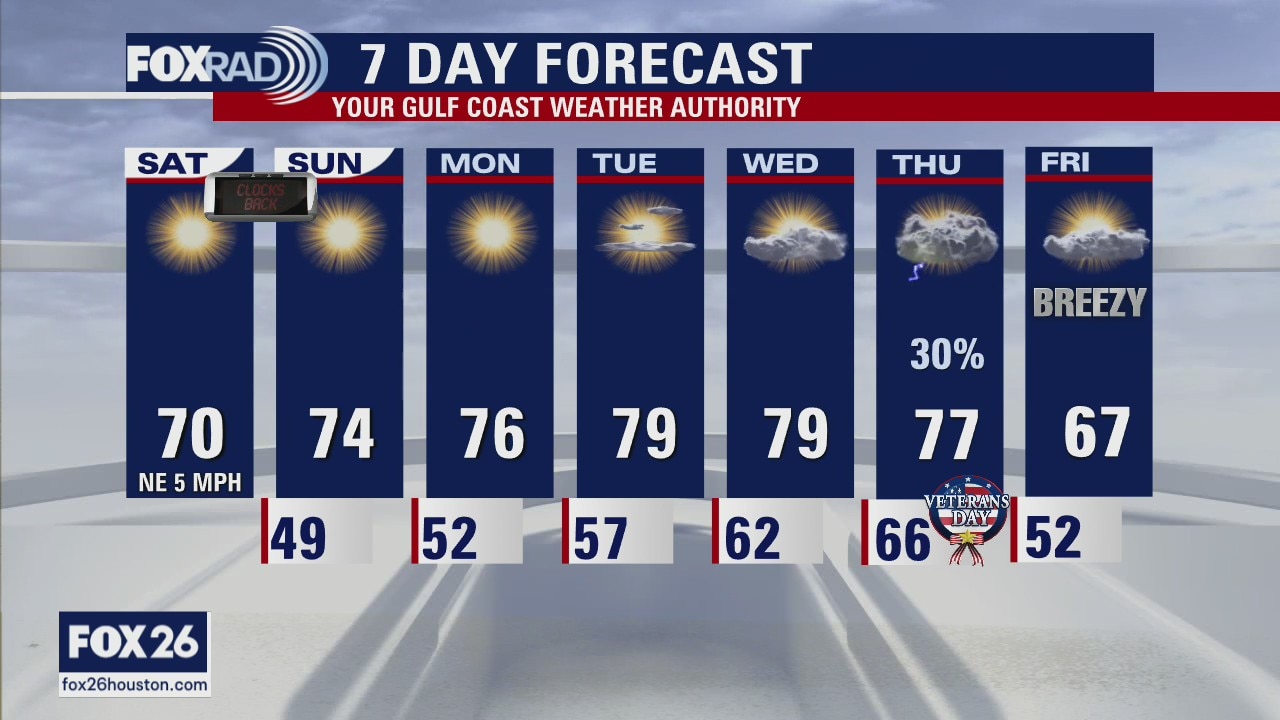
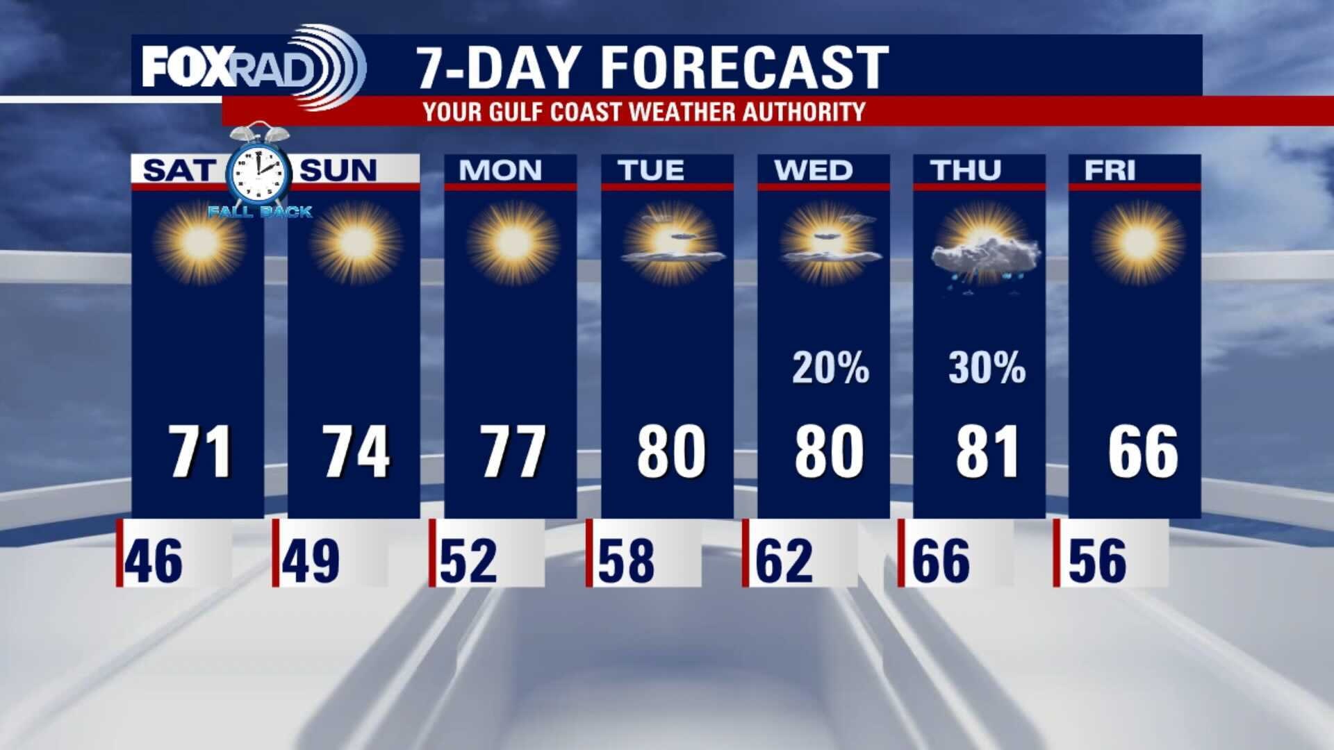
Friday night leading into Saturday morning weather forecast
It will be cool in the mornings and mild in the afternoons over the weekend. It warms into the middle of next week until the next front arrives around Thursday. Don't forget to set your clocks back an hour Saturday night before going to bed.
It will be cool in the mornings and mild in the afternoons over the weekend. It warms into the middle of next week until the next front arrives around Thursday. Don't forget to set your clocks back an hour Saturday night before going to bed.
Friday evening weather forecast with Chief Meteorologist Dr. Jim Siebert
It will be cool in the mornings and mild in the afternoons over the weekend. It warms into the middle of next week until the next front arrives around Thursday. Don't forget to set your clocks back an hour Saturday night before going to bed.
It will be cool in the mornings and mild in the afternoons over the weekend. It warms into the middle of next week until the next front arrives around Thursday. Don't forget to set your clocks back an hour Saturday night before going to bed.
Cool morning followed by pleasant day!
This morning was the coolest since April and yesterday afternoon was the coolest high temperatures since February! Look for a pleasant, sunny day today with highs in the mid 60s. Lows this weekend will likely bring 30s and 40s for overnight lows with beautiful days in the 70s.
This morning was the coolest since April and yesterday afternoon was the coolest high temperatures since February! Look for a pleasant, sunny day today with highs in the mid 60s. Lows this weekend will likely bring 30s and 40s for overnight lows with beautiful days in the 70s.
Friday morning weather forecast
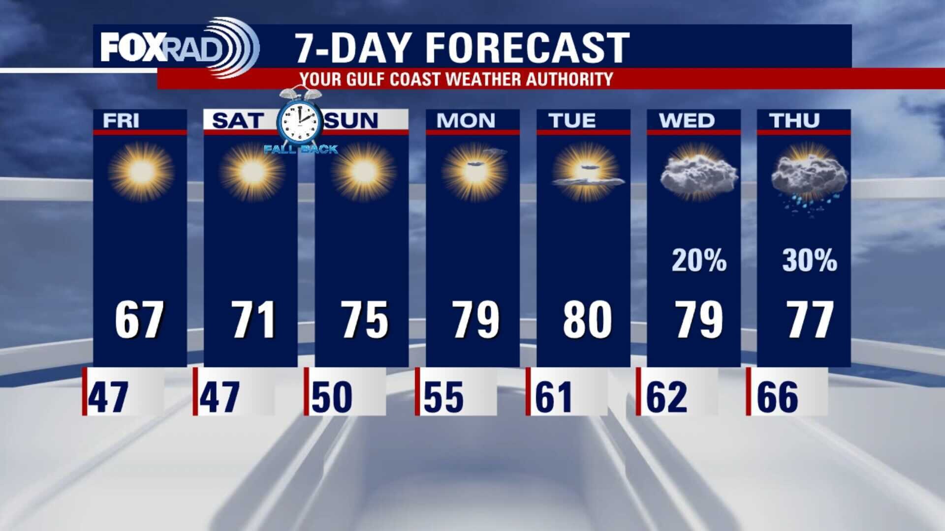
It will be a chilly start to Friday and Saturday, but the sunshine will feel nice in the afternoons. The temps will slowly warm into the coming week and the humidity will increase each day. The next chance for rain will start on Wednesday.
It will be a chilly start to Friday and Saturday, but the sunshine will feel nice in the afternoons. The temps will slowly warm into the coming week and the humidity will increase each day. The next chance for rain will start on Wednesday.
Thursday evening weather forecast with Chief Meteorologist Dr. Jim Siebert
It will be a chilly start to Friday and Saturday, but the sunshine will feel nice in the afternoons. The temps will slowly warm into the coming week and the humidity will increase each day. The next chance for rain will start on Wednesday.
It will be a chilly start to Friday and Saturday, but the sunshine will feel nice in the afternoons. The temps will slowly warm into the coming week and the humidity will increase each day. The next chance for rain will start on Wednesday.
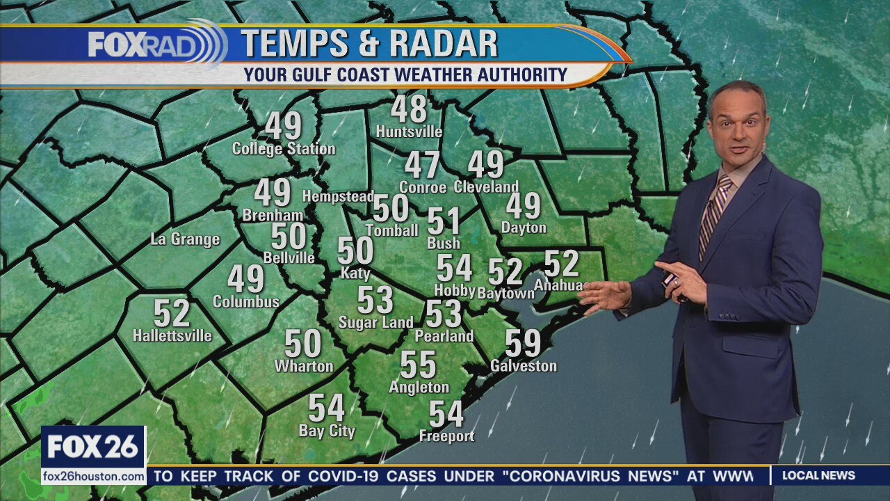
It's getting really chilly...
Clouds and a cool north breeze should give us the coolest afternoon since February today with highs near 60. The next few nights will be clear and chilly with most areas well into the 40s, but afternoons will be beautiful with highs in the upper 60s to low 70s. Dry conditions should remain in place through the middle of next week.
Clouds and a cool north breeze should give us the coolest afternoon since February today with highs near 60. The next few nights will be clear and chilly with most areas well into the 40s, but afternoons will be beautiful with highs in the upper 60s to low 70s. Dry conditions should remain in place through the middle of next week.
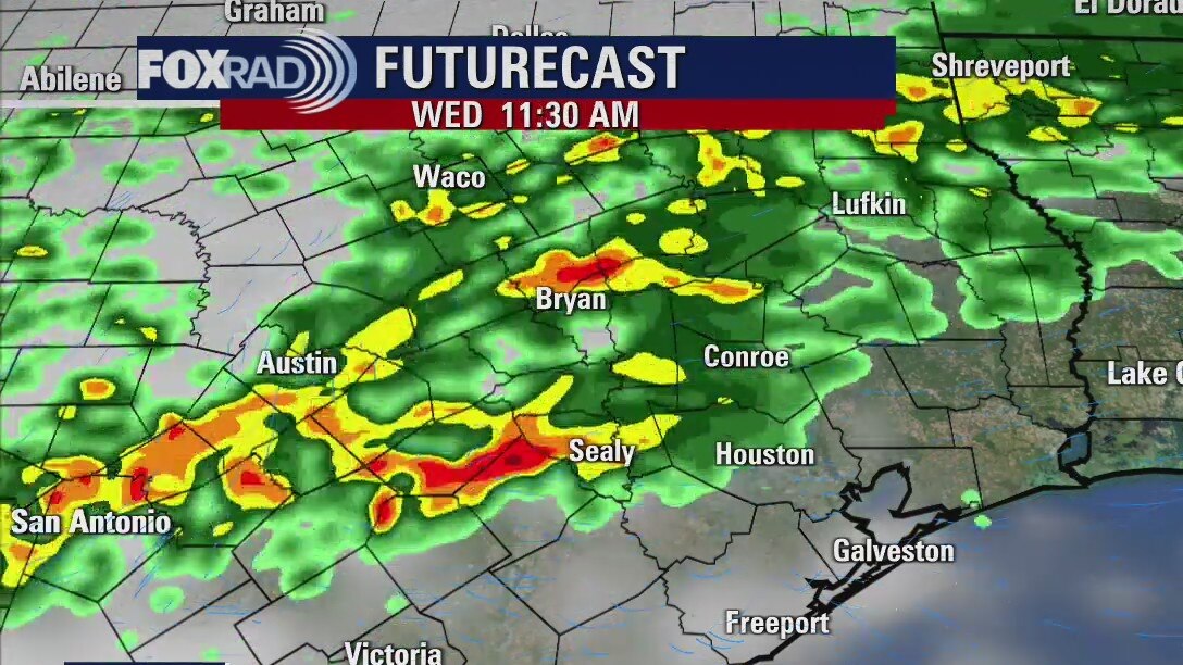
Thursday morning weather forecast
Showers are likely early on Thursday, but the skies will be clearing later in the day and it will remain cool. The rest of the week looks cool in the mornings and mild in the afternoons. There will be plenty of sunshine and low humidity.
Showers are likely early on Thursday, but the skies will be clearing later in the day and it will remain cool. The rest of the week looks cool in the mornings and mild in the afternoons. There will be plenty of sunshine and low humidity.
Wednesday evening weather forecast with Chief Meteorologist Dr. Jim Siebert
Showers are likely early on Thursday, but the skies will be clearing later in the day and it will remain cool. The rest of the week looks cool in the mornings and mild in the afternoons. There will be plenty of sunshine and low humidity.
Showers are likely early on Thursday, but the skies will be clearing later in the day and it will remain cool. The rest of the week looks cool in the mornings and mild in the afternoons. There will be plenty of sunshine and low humidity.
Cold front bringing cool temps & rain today
A cold front will bring rainy and cooler weather across the area this afternoon and evening. Temperatures should fall into the 50s and 60s by late today and remain stuck in the 50s all the way through Thursday with lingering showers. A sunny, cool and dry pattern follows for Friday through early next week.
A cold front will bring rainy and cooler weather across the area this afternoon and evening. Temperatures should fall into the 50s and 60s by late today and remain stuck in the 50s all the way through Thursday with lingering showers. A sunny, cool and dry pattern follows for Friday through early next week.
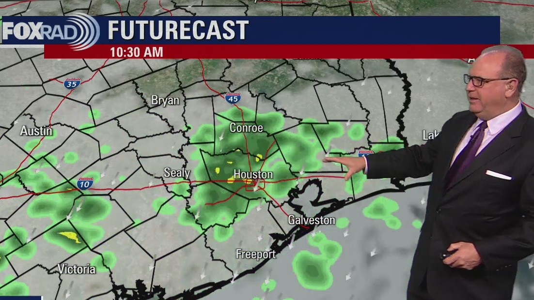
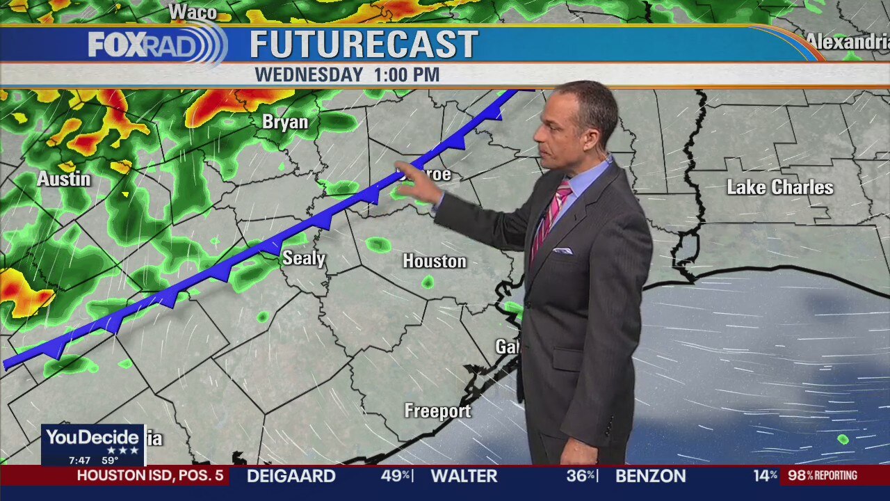
Wednesday morning weather forecast
Rain will become likely as a strong front arrives by early Thursday. Showers and storms will start later in the day on Wednesday and last into early Thursday. The rest of the week looks quiet and very fall-like with highs in the 60s.
Rain will become likely as a strong front arrives by early Thursday. Showers and storms will start later in the day on Wednesday and last into early Thursday. The rest of the week looks quiet and very fall-like with highs in the 60s.
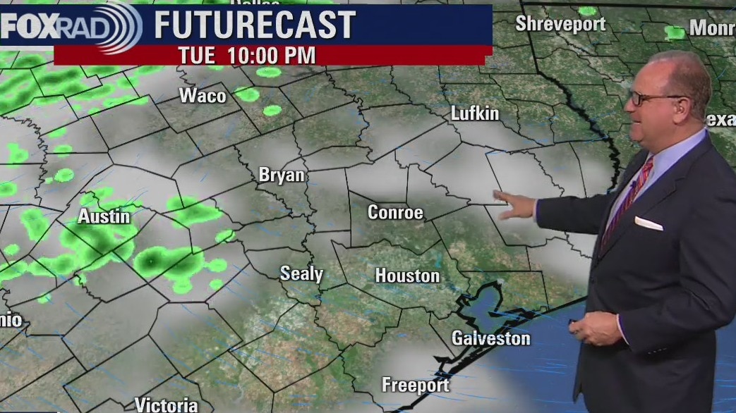
Tuesday evening weather forecast
Rain will become likely as a strong front arrives by early Thursday. Showers and storms will start later in the day on Wednesday and last into early Thursday. The rest of the week looks quiet and very fall-like with highs in the 60s.
Rain will become likely as a strong front arrives by early Thursday. Showers and storms will start later in the day on Wednesday and last into early Thursday. The rest of the week looks quiet and very fall-like with highs in the 60s.
Nice day for a ball game!
Weather looks nice for Game 6 of the World Series at Minute Maid Park tonight with temperatures falling from the upper 70s into the upper 60s. Tomorrow, especially in the evening, storms are on the way. A cold front will blow through overnight into Thursday morning and after some heavy downpours, temperature will drop for the rest of the week. Hopefully we'll celebrate an Astros World Series win with some cool fall air.
Weather looks nice for Game 6 of the World Series at Minute Maid Park tonight with temperatures falling from the upper 70s into the upper 60s. Tomorrow, especially in the evening, storms are on the way. A cold front will blow through overnight into Thursday morning and after some heavy downpours, temperature will drop for the rest of the week. Hopefully we'll celebrate an Astros World Series win with some cool fall air.
Monday evening weather forecast
Tuesday will be a nice day and things will change as the next cold front arrives late Wednesday and early Thursday. The week will end with highs in the 60s and lows in the 40s. That's a little chilly for our SE Texas in early November, but I?m not complaining.
Tuesday will be a nice day and things will change as the next cold front arrives late Wednesday and early Thursday. The week will end with highs in the 60s and lows in the 40s. That's a little chilly for our SE Texas in early November, but I?m not complaining.
Beautiful weather on Monday
After an amazing weekend with lows that reached the 40s, we have more beautiful weather ahead today. Look for highs near 80 with light winds and decent humidity. The main weather issue this week is a cold front scheduled for very early Thursday. Chilly fall weather will move in for the late part of this week.
After an amazing weekend with lows that reached the 40s, we have more beautiful weather ahead today. Look for highs near 80 with light winds and decent humidity. The main weather issue this week is a cold front scheduled for very early Thursday. Chilly fall weather will move in for the late part of this week.

Monday morning weather forecast
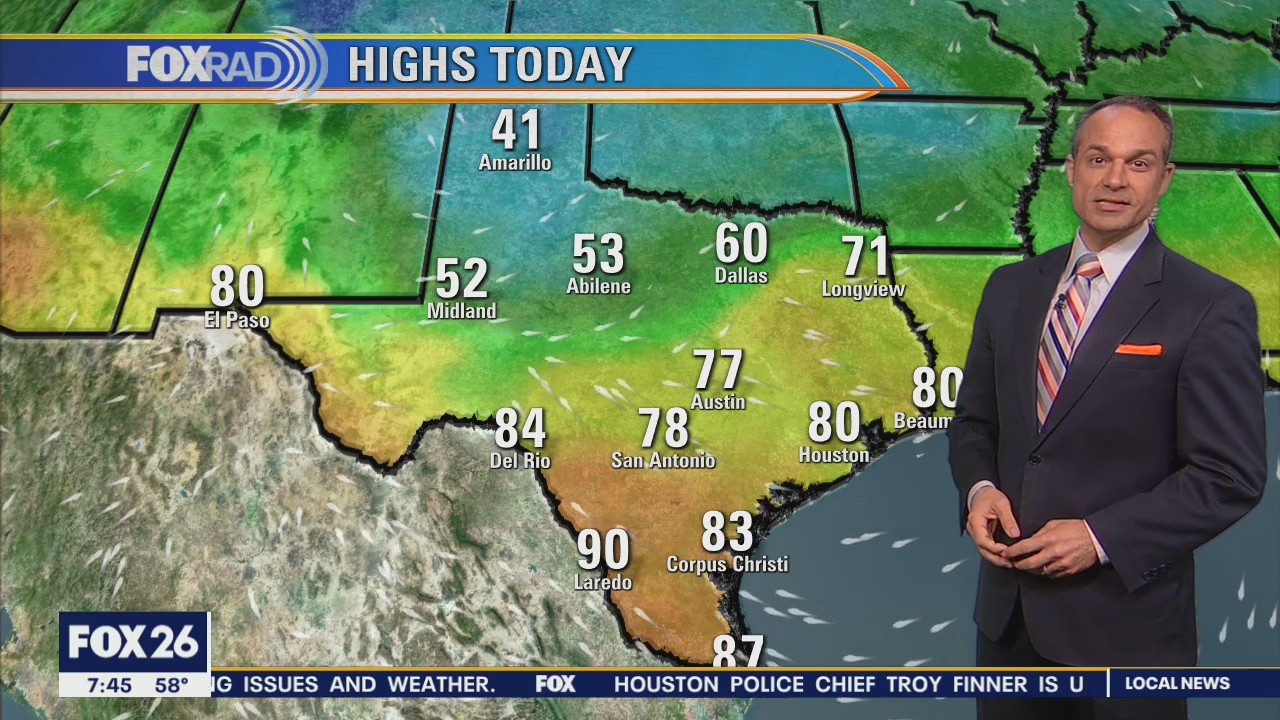
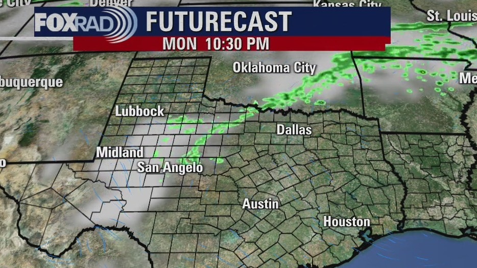
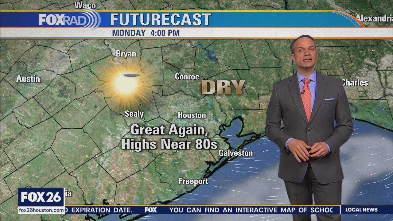
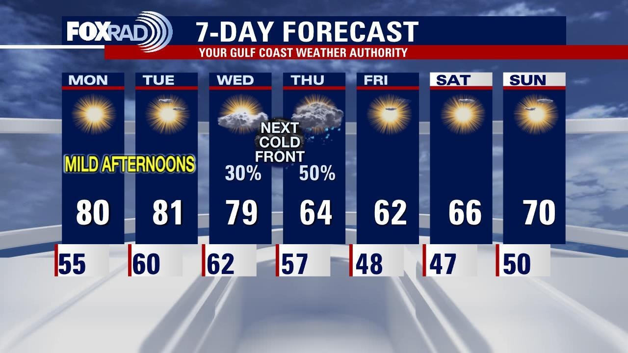
Look for a quiet and mild start to the work week across Southeast Texas. The next cold front is scheduled to arrive in Houston Wednesday night with showers and a few storms stretching into Thursday. That front should leave a pleasant end to the week and into the weekend with cool mornings and sunny afternoons.
Look for a quiet and mild start to the work week across Southeast Texas. The next cold front is scheduled to arrive in Houston Wednesday night with showers and a few storms stretching into Thursday. That front should leave a pleasant end to the week and into the weekend with cool mornings and sunny afternoons.
Sunday weather forecast
Look for a quiet and mild start to the work week across Southeast Texas. The next cold front is scheduled to arrive in Houston Wednesday night with showers and a few storms stretching into Thursday. That front should leave a pleasant end to the week and into the weekend with cool mornings and sunny afternoons.
Look for a quiet and mild start to the work week across Southeast Texas. The next cold front is scheduled to arrive in Houston Wednesday night with showers and a few storms stretching into Thursday. That front should leave a pleasant end to the week and into the weekend with cool mornings and sunny afternoons.
Saturday weather forecast with Meteorologist John Dawson
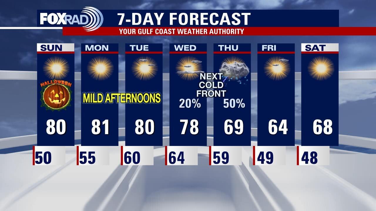
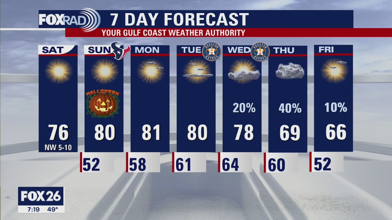
Halloween weather looking great in Houston. Look for temps in the upper 60s as the sun sets with lots of clear skies. Quiet days start the week in Southeast Texas as the next cold front is expected to arrive Wednesday night into the day Thursday.
Halloween weather looking great in Houston. Look for temps in the upper 60s as the sun sets with lots of clear skies. Quiet days start the week in Southeast Texas as the next cold front is expected to arrive Wednesday night into the day Thursday.
Saturday Morning Forecast with FOX26 Meteorologist Lena Maria Arango
Seasonably cool conditions linger through the start of Halloween weekend, but we'll see a brief warming trend at the start of next week with highs near 80. The next strong front looks to arrive Thursday, bringing us some rain and a fairly significant cool down heading into the first weekend of November.
Seasonably cool conditions linger through the start of Halloween weekend, but we'll see a brief warming trend at the start of next week with highs near 80. The next strong front looks to arrive Thursday, bringing us some rain and a fairly significant cool down heading into the first weekend of November.