

Breezy, chilly Wednesday evening in the 50s
Unseasonably cool weather will stick around through early next week with high temperatures in the 50s and overnight lows in the 30s and 40s. Next big round of rain is expected Saturday with a coastal low. Look for a nice warming trend just in time for Thanksgiving!
Unseasonably cool weather will stick around through early next week with high temperatures in the 50s and overnight lows in the 30s and 40s. Next big round of rain is expected Saturday with a coastal low. Look for a nice warming trend just in time for Thanksgiving!
Partly cloudy, chilly temps in the 50s Wednesday afternoon
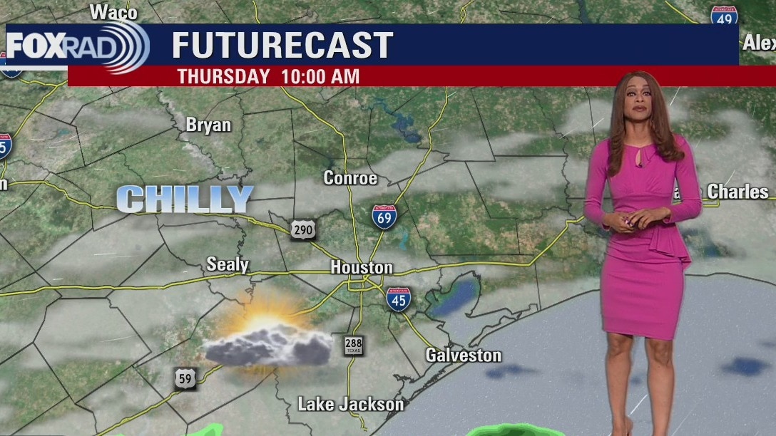
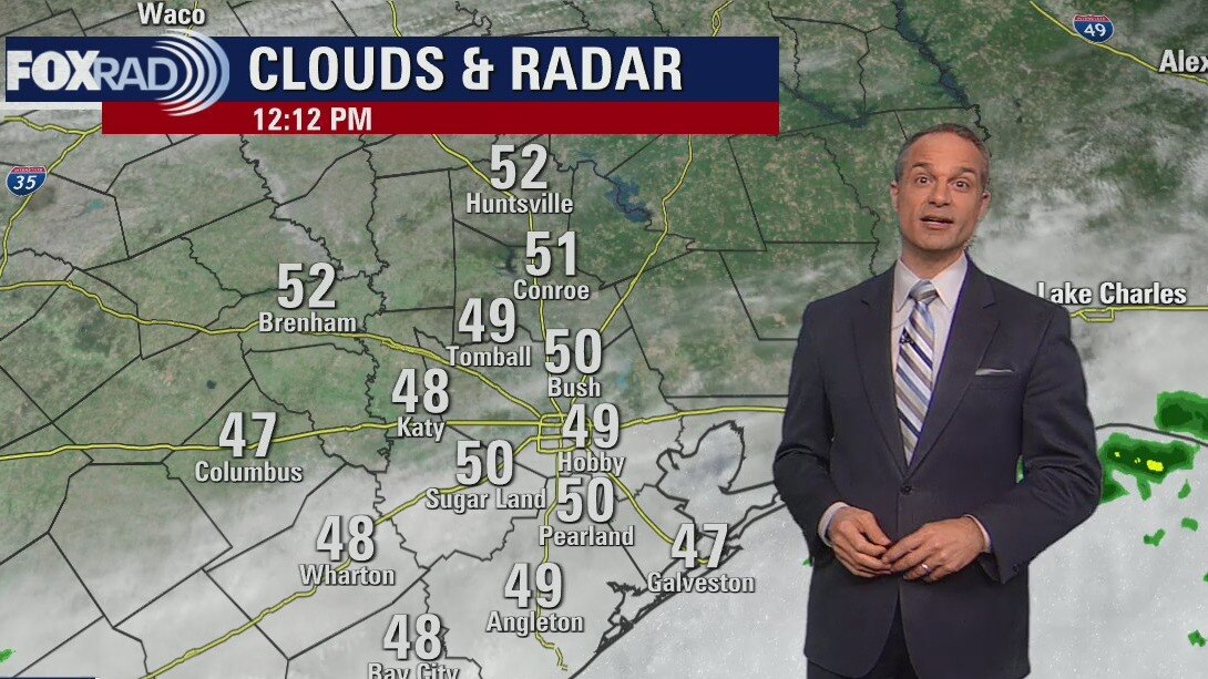
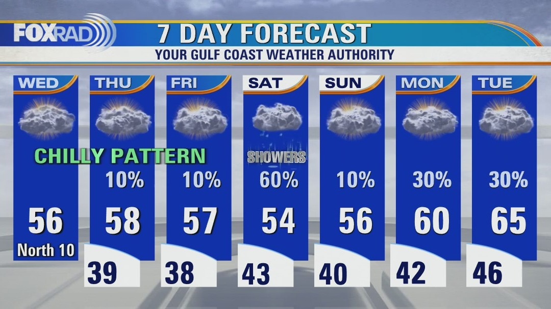
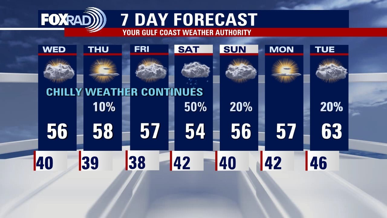
A chilly pattern remains across the Houston area with temperatures running about 15 degrees below normal. Look for highs in the 50s with lows in the upper 30s and low 40s. There may be a few light showers south of town on Thursday, but our best chance for rain arrives on Saturday. Models are becoming more consistent with a blanket of light to moderate rain throughout the day. Our temperature should moderate a bit Thanksgiving week.
A chilly pattern remains across the Houston area with temperatures running about 15 degrees below normal. Look for highs in the 50s with lows in the upper 30s and low 40s. There may be a few light showers south of town on Thursday, but our best chance for rain arrives on Saturday. Models are becoming more consistent with a blanket of light to moderate rain throughout the day. Our temperature should moderate a bit Thanksgiving week.
Colder Wednesday morning, then partly cloudy and chilly
A chilly pattern remains in place across the Houston area with temperatures running about 15 degrees below normal. Look for highs in the 50s with lows in the upper 30s and low 40s. There may be a few light showers south of town on Thursday, but our best chance for rain arrives on Saturday. Models are becoming more consistent with a blanket of light to moderate rain through the day. Our temperature should moderate a bit Thanksgiving week.
A chilly pattern remains in place across the Houston area with temperatures running about 15 degrees below normal. Look for highs in the 50s with lows in the upper 30s and low 40s. There may be a few light showers south of town on Thursday, but our best chance for rain arrives on Saturday. Models are becoming more consistent with a blanket of light to moderate rain through the day. Our temperature should moderate a bit Thanksgiving week.
Wednesday morning weather forecast
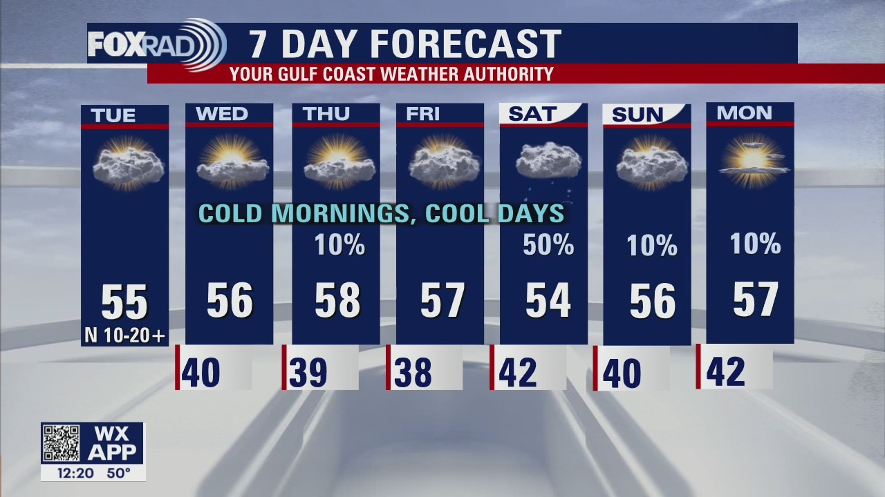
Houston is locked into a chilly patter for the rest of this week. Each day afternoon temperatures will struggle to break above the mid 50s with overnight lows near 40 in most spots, but look for some spots to see upper 30s Friday morning. This unusual November chill extends into the weekend with some rain possible as well.
Houston is locked into a chilly patter for the rest of this week. Each day afternoon temperatures will struggle to break above the mid 50s with overnight lows near 40 in most spots, but look for some spots to see upper 30s Friday morning. This unusual November chill extends into the weekend with some rain possible as well.
Tuesday evening weather forecast with Meteorologist John Dawson
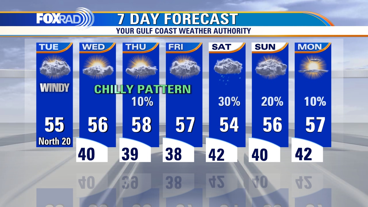
Houston is locked into a chilly pattern for the rest of this week. Each day afternoon temperatures will struggle to break above the mid-50s with overnight lows near 40 in most spots, but look for some spots to see the upper 30s Friday morning. This unusual November chill extends into the weekend with some rain possible as well.
Houston is locked into a chilly pattern for the rest of this week. Each day afternoon temperatures will struggle to break above the mid-50s with overnight lows near 40 in most spots, but look for some spots to see the upper 30s Friday morning. This unusual November chill extends into the weekend with some rain possible as well.
Tuesday afternoon weather forecast with Chief Meteorologist Mike Iscovitz
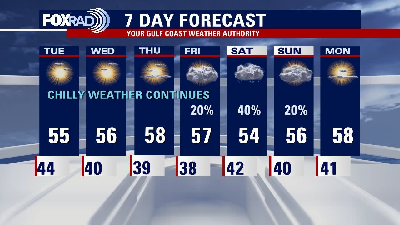
Chilly air is here to stay for the rest of the week and the weekend. Each day temps will struggle to break above the mid-50s with overnight lows near 40 in most spots but with some 30s possible Friday morning. In the meantime, bundle up this morning with wind chills in the upper 30s.
Chilly air is here to stay for the rest of the week and the weekend. Each day temps will struggle to break above the mid-50s with overnight lows near 40 in most spots but with some 30s possible Friday morning. In the meantime, bundle up this morning with wind chills in the upper 30s.
Blustery Tuesday morning, then partly sunny & chilly
Chilly air is here to stay for the rest of the week and the weekend. Each day temps will struggle to break above the mid 50s with overnight lows near 40 in most spots, but with some 30s possible Friday morning. In the meantime, bundle up this morning with wind chills in the upper 30s.
Chilly air is here to stay for the rest of the week and the weekend. Each day temps will struggle to break above the mid 50s with overnight lows near 40 in most spots, but with some 30s possible Friday morning. In the meantime, bundle up this morning with wind chills in the upper 30s.
Tuesday morning weather forecast
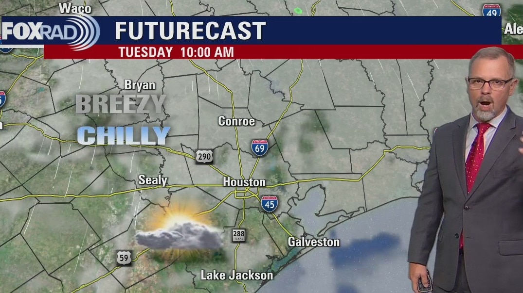
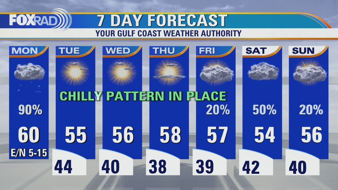
After a messy Monday, Southeast Texas will lock into a chilly pattern for the rest of the week. Houston will see mornings in the 40s with afternoon high temperatures only in the 50s. Look for another round of showers or storms on Saturday as another storm system will move in at the start of the weekend.
After a messy Monday, Southeast Texas will lock into a chilly pattern for the rest of the week. Houston will see mornings in the 40s with afternoon high temperatures only in the 50s. Look for another round of showers or storms on Saturday as another storm system will move in at the start of the weekend.
Monday evening weather forecast with Meteorologist John Dawson
After a messy Monday, Southeast Texas will lock into a chilly pattern for the rest of the week. Houston will see mornings in the 40s with afternoon high temperatures only in the 50s. Look for another round of showers or storms on Saturday as another storm system will move in at the start of the weekend.
After a messy Monday, Southeast Texas will lock into a chilly pattern for the rest of the week. Houston will see mornings in the 40s with afternoon high temperatures only in the 50s. Look for another round of showers or storms on Saturday as another storm system will move in at the start of the weekend.

Monday afternoon weather forecast with Chief Meteorologist Mike Iscovitz
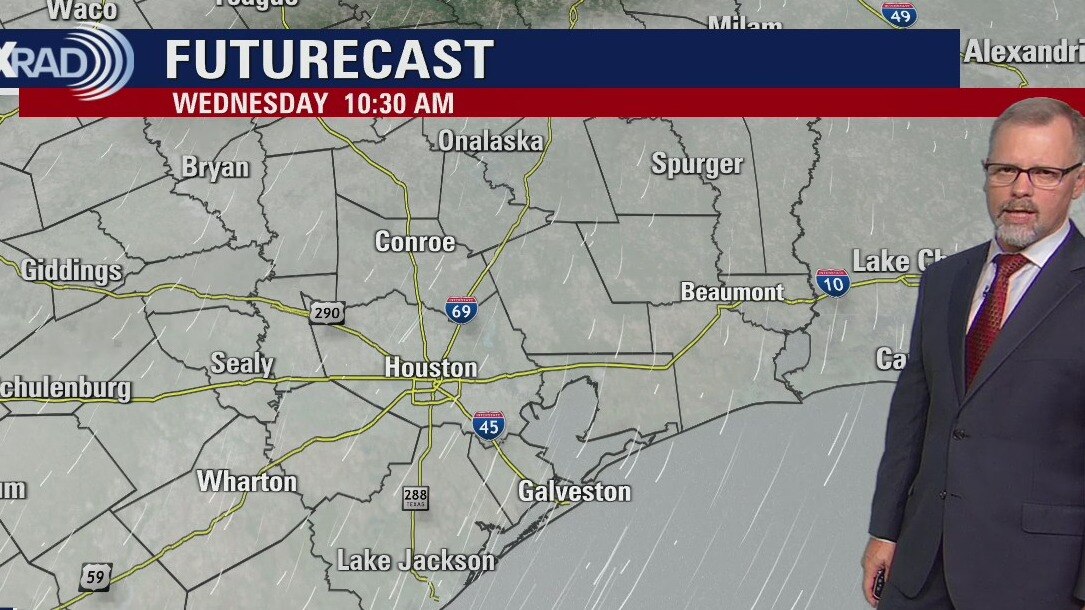
Prepare for a wintry week across the Houston area. It's going to be a "messy Monday" with afternoon chilly rain and a few heavy downpours. 2-3" of rain are possible, especially from Houston to Clear Lake, Galveston, and the Brazosport area. The rest of the week will be cold with lows in the 30s and 40s and highs in the 50s.
Prepare for a wintry week across the Houston area. It's going to be a "messy Monday" with afternoon chilly rain and a few heavy downpours. 2-3" of rain are possible, especially from Houston to Clear Lake, Galveston, and the Brazosport area. The rest of the week will be cold with lows in the 30s and 40s and highs in the 50s.
Cloudy and chilly Monday morning, then rainy with a few heavy storms
Prepare for a wintry week across the Houston area. It's going to be a "messy Monday" with afternoon chilly rain and a few heavy downpours. 2-3" of rain are possible, especially from Houston to Clear Lake, Galveston and the Brazosport area. The rest of the week will be cold with lows in the 30s and 40s and highs in the 50s.
Prepare for a wintry week across the Houston area. It's going to be a "messy Monday" with afternoon chilly rain and a few heavy downpours. 2-3" of rain are possible, especially from Houston to Clear Lake, Galveston and the Brazosport area. The rest of the week will be cold with lows in the 30s and 40s and highs in the 50s.

Partly cloudy, temps in the 50s this Sunday evening
Monday starts off cloudy and cool with a few isolated showers. Showers become more widespread in the afternoon with some heavy downpours and a few stronger storms. Houston will see chilly temperatures for the remainder of the week. Another front at the end of the week should bring back some overnight lows in the 30s along with some more chances for rain.
Monday starts off cloudy and cool with a few isolated showers. Showers become more widespread in the afternoon with some heavy downpours and a few stronger storms. Houston will see chilly temperatures for the remainder of the week. Another front at the end of the week should bring back some overnight lows in the 30s along with some more chances for rain.
Sunday weather forecast with Meteorologist Lena Maria Arango
The growing season has ended for a handful of our northern locations experiencing their first freeze of the season this morning. This afternoon will be sunny and dry, with highs similar to yesterday. Monday will be off to a cloudy, cool, and showery start but things could get messy during the afternoon-evening hours. Be on the lookout for a few stronger storms, and heavy downpours mainly south of I-10. We stay chilly for the remainder of the week, keeping our eyes on a couple of other systems that as of right now don't look to bring much rain. But, we will have to also watch for the possibility of more cold weather alerts overnight Thursday into Friday morning.
The growing season has ended for a handful of our northern locations experiencing their first freeze of the season this morning. This afternoon will be sunny and dry, with highs similar to yesterday. Monday will be off to a cloudy, cool, and showery start but things could get messy during the afternoon-evening hours. Be on the lookout for a few stronger storms, and heavy downpours mainly south of I-10. We stay chilly for the remainder of the week, keeping our eyes on a couple of other systems that as of right now don't look to bring much rain. But, we will have to also watch for the possibility of more cold weather alerts overnight Thursday into Friday morning.

Temps in the lower 60s, freeze warning for Saturday evening
Bundle up for a cold night across southeast Texas with a chilly Sunday morning. A Freeze Warning has been issued for the northern most counties in the FOX 26 area. The sunny skies continues in the afternoon but are replace with rainy overcast clouds on Monday. Look for cool temperatures all week with another chance for rain on Thursday.
Bundle up for a cold night across southeast Texas with a chilly Sunday morning. A Freeze Warning has been issued for the northern most counties in the FOX 26 area. The sunny skies continues in the afternoon but are replace with rainy overcast clouds on Monday. Look for cool temperatures all week with another chance for rain on Thursday.

Saturday weather forecast with Meteorologist Lena Maria Arango
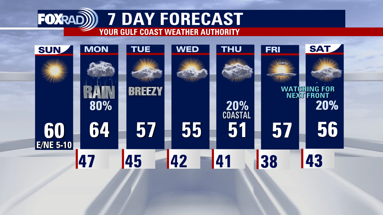
We're in for a chilly, but dry weekend. Sunday will be less breezy, but there is a freeze watch in effect overnight for our far northern counties where temperatures may dip to, or slightly below 32?. Take proper precautions to protect the 4 p's! On Monday, two systems will converge - an incoming trough from the northwest and a developing coastal low. That's going to lead to a raw and rainy start to the work week, with a couple of isolated storms and downpours in the mix. Past that, things get a little fuzzy on the specifics of our next rain chance so check back for updates and changes. The one thing that is for certain, is that our cold pattern will be staying in place for now.
We're in for a chilly, but dry weekend. Sunday will be less breezy, but there is a freeze watch in effect overnight for our far northern counties where temperatures may dip to, or slightly below 32?. Take proper precautions to protect the 4 p's! On Monday, two systems will converge - an incoming trough from the northwest and a developing coastal low. That's going to lead to a raw and rainy start to the work week, with a couple of isolated storms and downpours in the mix. Past that, things get a little fuzzy on the specifics of our next rain chance so check back for updates and changes. The one thing that is for certain, is that our cold pattern will be staying in place for now.

Cold front bringing chilly temps, wind advisory expected this weekend in SE Texas
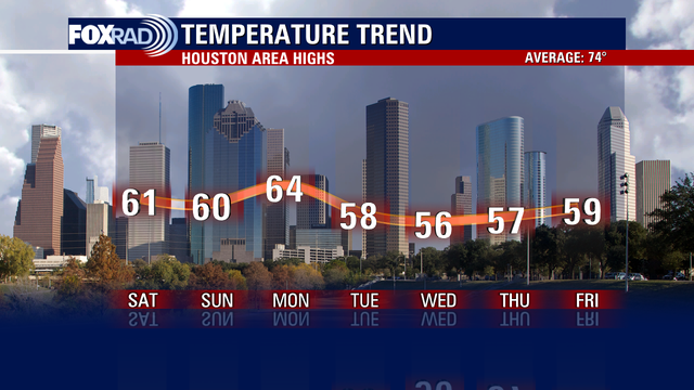
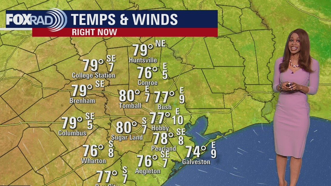
While it's been a warm weekend this November across southeast Texas, an approaching cold front is expected to bring temperatures down to the 50s and 60s this weekend.
While it's been a warm weekend this November across southeast Texas, an approaching cold front is expected to bring temperatures down to the 50s and 60s this weekend.

Heavy rain, cold front rolling in this Friday evening
Strong cold front is moving through the Houston area bringing some heavy downpours at times and a few storms. There's still a low risk of a strong storm through the early evening. The main risk would be a brief wind gust of 50-60 mph and hail up to 1" along with brief heavy rain that could lead to a few flooded streets. Rain will continue through tonight tapering off very early Saturday. Much colder air rolls in just in time for the weekend with highs only near 60 and lows in the 30s and 40s. That means temperatures 10-20 degrees below average! So throw on a few extra layers, crank up the heater and get ready for a chilly weekend. Cool air hangs around all of next week too with another round of rain likely Monday.
Strong cold front is moving through the Houston area bringing some heavy downpours at times and a few storms. There's still a low risk of a strong storm through the early evening. The main risk would be a brief wind gust of 50-60 mph and hail up to 1" along with brief heavy rain that could lead to a few flooded streets. Rain will continue through tonight tapering off very early Saturday. Much colder air rolls in just in time for the weekend with highs only near 60 and lows in the 30s and 40s. That means temperatures 10-20 degrees below average! So throw on a few extra layers, crank up the heater and get ready for a chilly weekend. Cool air hangs around all of next week too with another round of rain likely Monday.


Houston Weather: Storms bringing much cooler weather
Veterans Day weather forecast.
Veterans Day weather forecast.

Houston Weather: Veterans Day storms bringing much cooler weather for the weekend
Veterans Day weather forecast.
Veterans Day weather forecast.
Warm, temps in the 70s Thursday evening as cold front approaches
Big changes are right around the corner for all of SE Texas as a strong cold front races into the state. Enjoy our last mild night for awhile with lows in the 60s. Look for patchy fog and a few showers Veterans Day morning with showers and storms increasing for the second half of the day. There's even a low category 1 risk out of 5 for an isolated severe storm Friday with a brief damaging wind gust the main threat along with some hail. Best chance for storms will be from around 2-8 pm. Showers fade early Saturday just as chilly air enters. We'll start off in the 40s and 50s Saturday and only climb to near 60. with the gusty north breeze, it will feel even colder than that. 30s and 40s are likely early Sunday so prepare to bundle up! Another decent round of rain is expected by Monday. Nicole has now weakened to a Tropical Storm with winds of 45 mph on the west coast of Florida and is expected to weaken to a Tropical Depression tonight as it moves inland into southern Georgia.
Big changes are right around the corner for all of SE Texas as a strong cold front races into the state. Enjoy our last mild night for awhile with lows in the 60s. Look for patchy fog and a few showers Veterans Day morning with showers and storms increasing for the second half of the day. There's even a low category 1 risk out of 5 for an isolated severe storm Friday with a brief damaging wind gust the main threat along with some hail. Best chance for storms will be from around 2-8 pm. Showers fade early Saturday just as chilly air enters. We'll start off in the 40s and 50s Saturday and only climb to near 60. with the gusty north breeze, it will feel even colder than that. 30s and 40s are likely early Sunday so prepare to bundle up! Another decent round of rain is expected by Monday. Nicole has now weakened to a Tropical Storm with winds of 45 mph on the west coast of Florida and is expected to weaken to a Tropical Depression tonight as it moves inland into southern Georgia.