


Tropical Weather Forecast - November 14, 2025
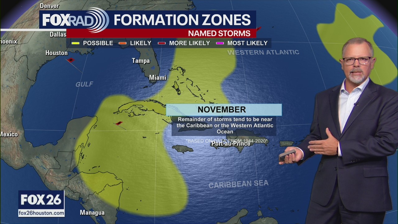
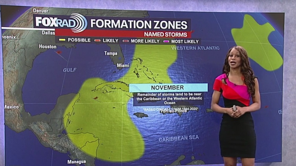
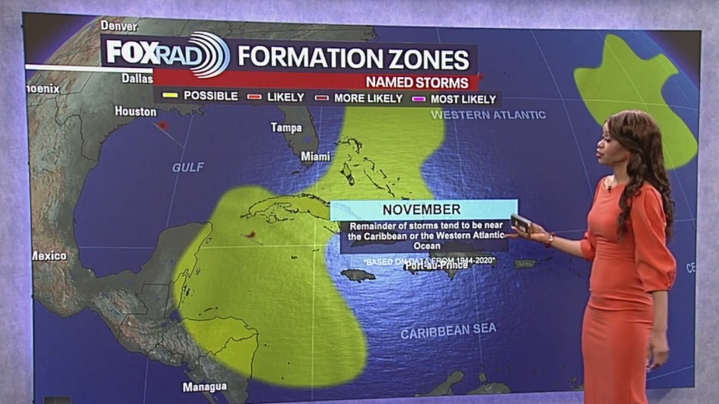
So far this season, we have had 13 named storms, 5 hurricanes and four major hurricanes. Tropical cyclone activity is not expected in the Atlantic Basin during the next 7 days. Hurricane season lasts for another 16 days. Any chance for additional tropical activity for the Gulf for the rest of this month is extremely low. The one area to watch with at least a slight chance for development would be the Western portion of the Caribbean. But even there, chances are very low. Overall activity is winding down as the season gets closer to ending.
So far this season, we have had 13 named storms, 5 hurricanes and four major hurricanes. Tropical cyclone activity is not expected in the Atlantic Basin during the next 7 days. Hurricane season lasts for another 16 days. Any chance for additional tropical activity for the Gulf for the rest of this month is extremely low. The one area to watch with at least a slight chance for development would be the Western portion of the Caribbean. But even there, chances are very low. Overall activity is winding down as the season gets closer to ending.

Tropical Weather Forecast - November 12, 2025
So far this season, we have had 13 named storms, 5 hurricanes and four major hurricanes. Three of those major hurricanes have been category fives, which hasn't happened in a single season in about twenty years! Tropical cyclone activity is not expected in the Atlantic Basin during the next 7 days. Hurricane season lasts through the end of this month. The one area to watch with at least a slight chance for development would be the Western portion of the Caribbean. But even there, chances are very low. Overall activity is winding down as the season gets closer to ending.
So far this season, we have had 13 named storms, 5 hurricanes and four major hurricanes. Three of those major hurricanes have been category fives, which hasn't happened in a single season in about twenty years! Tropical cyclone activity is not expected in the Atlantic Basin during the next 7 days. Hurricane season lasts through the end of this month. The one area to watch with at least a slight chance for development would be the Western portion of the Caribbean. But even there, chances are very low. Overall activity is winding down as the season gets closer to ending.
Tropical Weather Forecast - November 11, 2025
So far this season, we have had 13 named storms, 5 hurricanes and four major hurricanes. Three of those major hurricanes have been category fives, which hasn't happened in a single season in about twenty years! Tropical cyclone activity is not expected in the Atlantic Basin during the next 7 days. Hurricane season lasts for another 19 days. Any chance for additional tropical activity for the Gulf for the rest of this month is extremely low. The one area to watch with at least a slight chance for development would be the Western portion of the Caribbean. But even there, chances are very low. Overall activity is winding down as the season gets closer to ending.
So far this season, we have had 13 named storms, 5 hurricanes and four major hurricanes. Three of those major hurricanes have been category fives, which hasn't happened in a single season in about twenty years! Tropical cyclone activity is not expected in the Atlantic Basin during the next 7 days. Hurricane season lasts for another 19 days. Any chance for additional tropical activity for the Gulf for the rest of this month is extremely low. The one area to watch with at least a slight chance for development would be the Western portion of the Caribbean. But even there, chances are very low. Overall activity is winding down as the season gets closer to ending.

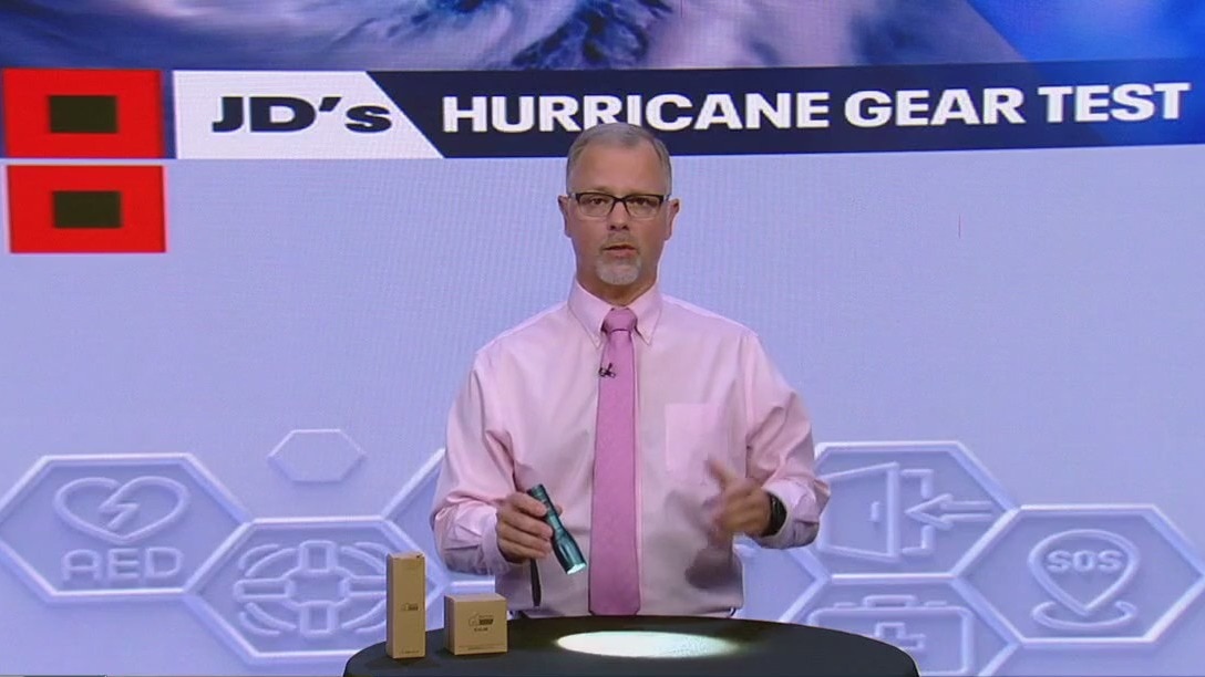
Acebeam X25 Power Bank Flashlight | Hurricane Gear Test
FOX 26 Meteorologist John Dawson shows off the Acebeam X25 Power Bank Flashlight that could be useful in your hurricane kit.
FOX 26 Meteorologist John Dawson shows off the Acebeam X25 Power Bank Flashlight that could be useful in your hurricane kit.
Gorilla Grip Flashlight | Hurricane Gear Test
You're going to need a flashlight on your hurricane kit and Meteorologist John Dawson takes a look at the Gorilla Grip flashlight that is fairly inexpensive.
You're going to need a flashlight on your hurricane kit and Meteorologist John Dawson takes a look at the Gorilla Grip flashlight that is fairly inexpensive.

4Patriots Power Solar Generator | Hurricane Gear Test
Power can go out at any time of the year, especially during a hurricane. FOX 26's Meteorologist Joh Dawson shows us a the 4Patriots generator.
Power can go out at any time of the year, especially during a hurricane. FOX 26's Meteorologist Joh Dawson shows us a the 4Patriots generator.
Tropical weather update - November 9, 2025
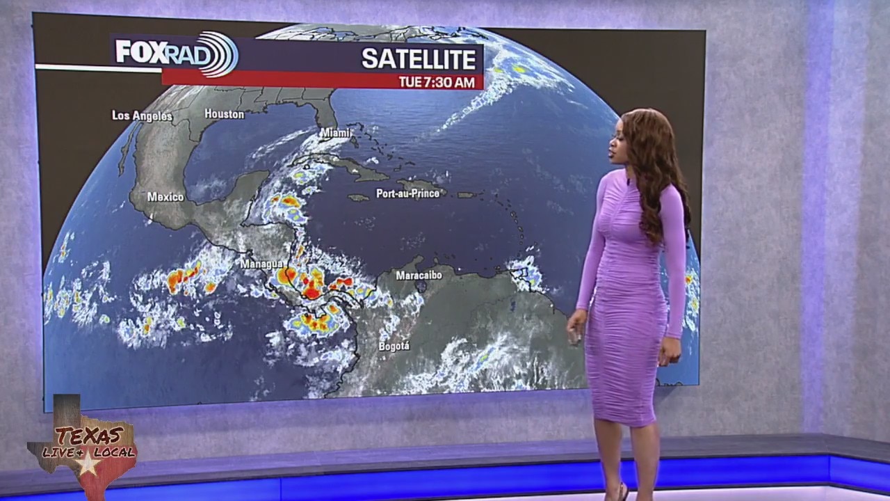
Tropical cyclone formation is not expected during the next 7 days for the North Atlantic, Caribbean Sea and the Gulf of America.
Tropical cyclone formation is not expected during the next 7 days for the North Atlantic, Caribbean Sea and the Gulf of America.
Tropical weather update - November 8, 2025
Tropical cyclone activity is not expected in the Atlantic Basin during the next 7 days. Hurricane season lasts until November 30th. Any chance for additional tropical activity for the Gulf looks extremely low.
Tropical cyclone activity is not expected in the Atlantic Basin during the next 7 days. Hurricane season lasts until November 30th. Any chance for additional tropical activity for the Gulf looks extremely low.
Tropical Weather Forecast - November 6, 2025
So far this season, we have had 13 named storms, 5 hurricanes and four major hurricanes. Tropical cyclone activity is not expected in the Atlantic Basin during the next 7 days. Hurricane season lasts until November 30th. Any chance for additional tropical activity for the Gulf for the rest of this month is extremely low. The one area to watch with at least a slight chance for development would be the Western portion of the Caribbean. But even there, chances are very low. Overall activity is winding down as the season gets closer to ending.
So far this season, we have had 13 named storms, 5 hurricanes and four major hurricanes. Tropical cyclone activity is not expected in the Atlantic Basin during the next 7 days. Hurricane season lasts until November 30th. Any chance for additional tropical activity for the Gulf for the rest of this month is extremely low. The one area to watch with at least a slight chance for development would be the Western portion of the Caribbean. But even there, chances are very low. Overall activity is winding down as the season gets closer to ending.
Tropical Weather Forecast: Tropics calm for now
Tropical cyclone activity is not expected in the Atlantic Basin during the next 7 days. Hurricane season lasts until November 30th. Any chance for additional tropical activity for the Gulf for the rest of this month is extremely low. The one area to watch with at least a slight chance for development would be the Western portion of the Caribbean. But even there, chances are very low. Overall activity is winding down as the season gets closer to ending.
Tropical cyclone activity is not expected in the Atlantic Basin during the next 7 days. Hurricane season lasts until November 30th. Any chance for additional tropical activity for the Gulf for the rest of this month is extremely low. The one area to watch with at least a slight chance for development would be the Western portion of the Caribbean. But even there, chances are very low. Overall activity is winding down as the season gets closer to ending.
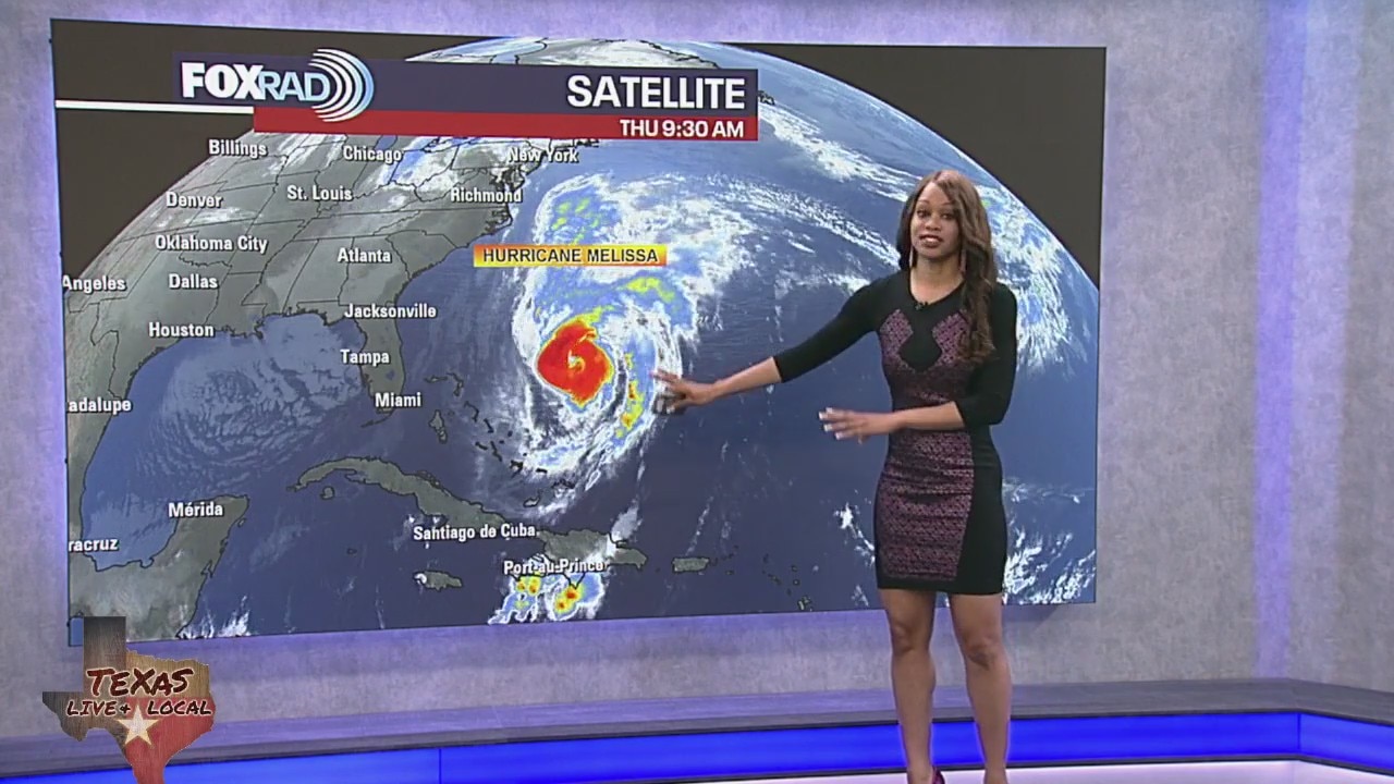
Tropical weather update: November 4, 2025
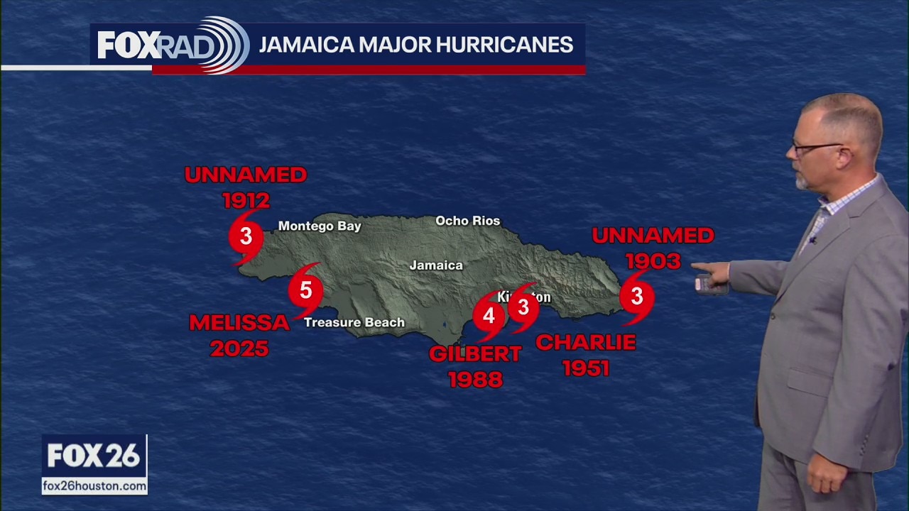
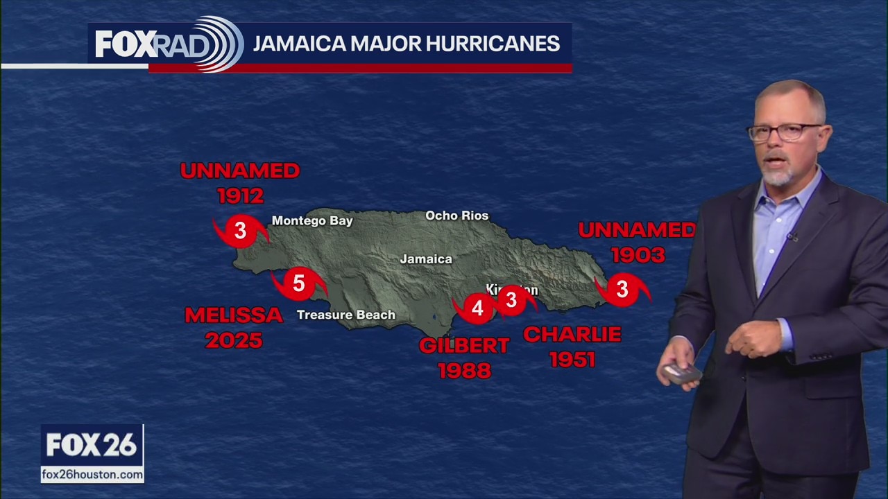
It has been a week since Hurricane Melissa devastated Jamaica, hitting the island as a monster category 5 with 185 mph winds. Tropics have calmed down since then and tropical cyclone activity is not expected in the Atlantic Basin during the next 7 days. Hurricane season lasts for another 26 days, ending on November 30th. Any chance for additional tropical activity for the Gulf for the rest of this month is extremely low. There's still a slight risk for possible tropical systems to develop in the Western Atlantic and Western Caribbean. But overall activity is winding down as the season gets closer to ending.
It has been a week since Hurricane Melissa devastated Jamaica, hitting the island as a monster category 5 with 185 mph winds. Tropics have calmed down since then and tropical cyclone activity is not expected in the Atlantic Basin during the next 7 days. Hurricane season lasts for another 26 days, ending on November 30th. Any chance for additional tropical activity for the Gulf for the rest of this month is extremely low. There's still a slight risk for possible tropical systems to develop in the Western Atlantic and Western Caribbean. But overall activity is winding down as the season gets closer to ending.
Tropical weather update - November 3, 2025
The National Hurricane Center issued their last advisory on Melissa Friday. Tropical cyclone activity is not expected in the Atlantic Basin during the next 7 days. Hurricane season lasts for about another month, ending on November 30th. Any chance for additional tropical activity for the Gulf for the rest of this month is extremely low. There's still a slight risk for possible tropical systems to develop in the Western Atlantic and Western Caribbean. But overall activity is winding down as the season gets closer to ending.
The National Hurricane Center issued their last advisory on Melissa Friday. Tropical cyclone activity is not expected in the Atlantic Basin during the next 7 days. Hurricane season lasts for about another month, ending on November 30th. Any chance for additional tropical activity for the Gulf for the rest of this month is extremely low. There's still a slight risk for possible tropical systems to develop in the Western Atlantic and Western Caribbean. But overall activity is winding down as the season gets closer to ending.


Houston Caribbean community holds town hall discussing aid for those impacted by Hurricane Melissa
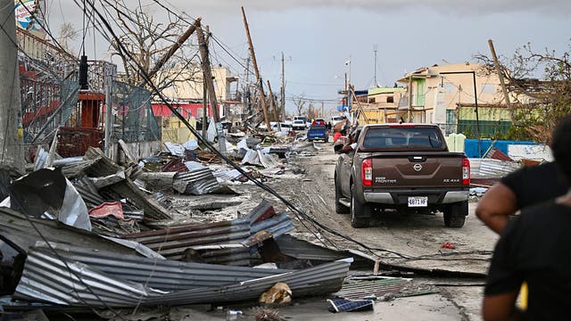
The Houston Caribbean community held a town hall discussing aid for those impacted by Hurricane Melissa. Hurricane Melissa hit Jamaica as a Category 5 storm and has left widespread devastation.
The Houston Caribbean community held a town hall discussing aid for those impacted by Hurricane Melissa. Hurricane Melissa hit Jamaica as a Category 5 storm and has left widespread devastation.
Tropical weather update - Nov. 2, 2025
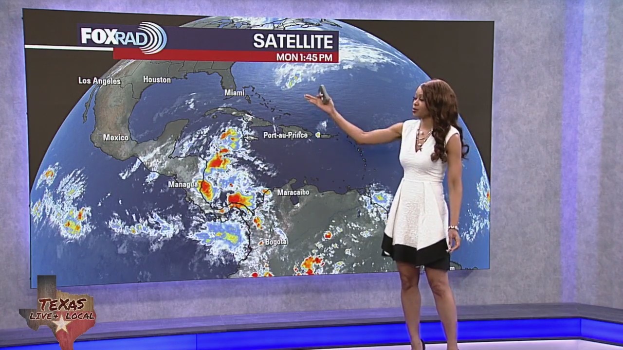
For the North Atlantic Ocean, Caribbean Sea, and the Gulf of America the National Hurricane Center is not expecting tropical cyclone formation over the next 7 days.
For the North Atlantic Ocean, Caribbean Sea, and the Gulf of America the National Hurricane Center is not expecting tropical cyclone formation over the next 7 days.

Hurricane Melissa: Rising death toll, desperate pleas for aid
It’s been nearly a week since Hurricane Melissa made its first catastrophic landfall in Jamaica, and the death toll is continuing to rise.
It’s been nearly a week since Hurricane Melissa made its first catastrophic landfall in Jamaica, and the death toll is continuing to rise.
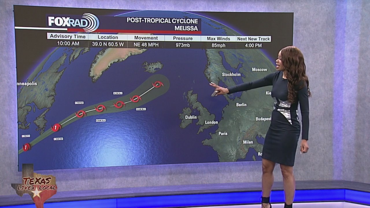
Tropical weather update: Melissa now post-tropical cyclone
The National Hurricane Center has issued its last advisory on Melissa, it is now a post-tropical cyclone over the northwest Atlantic. Meteorologist John Dawson looks back on how Melissa will land in the record books.
The National Hurricane Center has issued its last advisory on Melissa, it is now a post-tropical cyclone over the northwest Atlantic. Meteorologist John Dawson looks back on how Melissa will land in the record books.
Tropical weather update - October 31, 2025
Hurricane Melissa brushed by Bermuda last night and this morning with a wind gust around 98 miles per hour reported. As of this afternoon, Melissa has lost tropical characteristics and is no longer a tropical system. However, it remains a powerful storm with very strong winds and is expected to bring some brief heavy rain to parts of Newfoundland tonight. No other systems are being monitored for tropical development in the Atlantic basin at this time. Hurricane season lasts for another month, ending on November 30th.
Hurricane Melissa brushed by Bermuda last night and this morning with a wind gust around 98 miles per hour reported. As of this afternoon, Melissa has lost tropical characteristics and is no longer a tropical system. However, it remains a powerful storm with very strong winds and is expected to bring some brief heavy rain to parts of Newfoundland tonight. No other systems are being monitored for tropical development in the Atlantic basin at this time. Hurricane season lasts for another month, ending on November 30th.
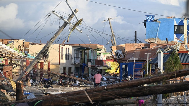

Hurricane Melissa death toll climbs after massive storm rips through Caribbean
Officials have reported deaths in multiple areas as Hurricane Melissa slammed parts of the Caribbean this week.
Officials have reported deaths in multiple areas as Hurricane Melissa slammed parts of the Caribbean this week.
Tropical weather update - October 30, 2025
Hurricane Melissa, after causing widespread catastrophic damage in Jamaica and Cuba, is now a Category 2 hurricane moving away from the Bahamas and racing toward the North Atlantic. The storm is forecast to pass just to the west of Bermuda this evening & tonight. Melissa poses no threat to the US mainland and will become "post-tropical" over the weekend as it moves over cooler waters. There are no other areas of concern in the Atlantic basin for development at this time. But keep in mind that hurricane season will continue for about another month. So stay alert.
Hurricane Melissa, after causing widespread catastrophic damage in Jamaica and Cuba, is now a Category 2 hurricane moving away from the Bahamas and racing toward the North Atlantic. The storm is forecast to pass just to the west of Bermuda this evening & tonight. Melissa poses no threat to the US mainland and will become "post-tropical" over the weekend as it moves over cooler waters. There are no other areas of concern in the Atlantic basin for development at this time. But keep in mind that hurricane season will continue for about another month. So stay alert.


Watch Live: Hurricane Melissa heads for Bermuda after causing devastation in Caribbean
Hurricane Melissa continues its devastating path across the Atlantic with a dangerous storm surge forecast for Bermuda on Thursday.
Hurricane Melissa continues its devastating path across the Atlantic with a dangerous storm surge forecast for Bermuda on Thursday.