


Ernesto becomes a hurricane again | FOX 26 Tropical Weather Forecast
Ernesto was a Tropical Storm Saturday night, but Sunday afternoon sees it back to hurricane strength. Swells generated by Ernesto are affecting portions of the Bahamas, Bermuda, the east coast of the United States, and Atlantic Canada. Life-threatening surf and rip current conditions are likely to continue in these areas during the next couple of days
Ernesto was a Tropical Storm Saturday night, but Sunday afternoon sees it back to hurricane strength. Swells generated by Ernesto are affecting portions of the Bahamas, Bermuda, the east coast of the United States, and Atlantic Canada. Life-threatening surf and rip current conditions are likely to continue in these areas during the next couple of days
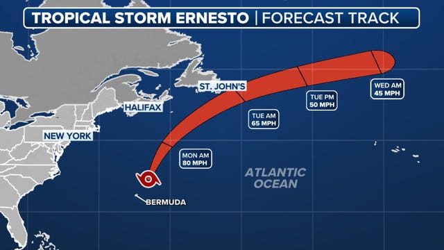

Ernesto weakens to tropical storm but could regain hurricane strength as it heads toward Atlantic Canada
At least two deaths in South Carolina have been attributed to the powerful rip currents that developed because of Ernesto.
At least two deaths in South Carolina have been attributed to the powerful rip currents that developed because of Ernesto.

Tropical update: Hurricane Ernesto lands in Bermuda
Hurricane Ernesto makes landfall on the island of Bermuda on Saturday morning. This storm is slow moving now but will speed up on Sunday.
Hurricane Ernesto makes landfall on the island of Bermuda on Saturday morning. This storm is slow moving now but will speed up on Sunday.


Ernesto makes landfall: See the impacts it will have on the East Coast
Beaches from Florida to Maine are expecting an increase in rip currents and surf that could make ocean ventures dangerous through the weekend.
Beaches from Florida to Maine are expecting an increase in rip currents and surf that could make ocean ventures dangerous through the weekend.

Ernesto continues track toward Bermuda
Hurricane Ernesto is barreling toward the island of Bermuda as a category two storm. The system could make a direct impact on the island on Saturday morning, bringing the threat for winds up to 100 mph. The forecast track keeps the system well away from the US East Coast, but over the next few days it looks like it will brush by the far eastern provinces of Canada and eventually bring some high wind and rain to places like Iceland, Ireland and Scotland. Elsewhere, everything is pretty quiet across the Atlantic basin. There?s a sizable plume of Saharan dust that has moved into the Atlantic Ocean, so for now activity is going to be limited, but we are getting into the busiest time of the year so by the end of this month and especially September , we still expect a flurry of tropical activity.
Hurricane Ernesto is barreling toward the island of Bermuda as a category two storm. The system could make a direct impact on the island on Saturday morning, bringing the threat for winds up to 100 mph. The forecast track keeps the system well away from the US East Coast, but over the next few days it looks like it will brush by the far eastern provinces of Canada and eventually bring some high wind and rain to places like Iceland, Ireland and Scotland. Elsewhere, everything is pretty quiet across the Atlantic basin. There?s a sizable plume of Saharan dust that has moved into the Atlantic Ocean, so for now activity is going to be limited, but we are getting into the busiest time of the year so by the end of this month and especially September , we still expect a flurry of tropical activity.

Hurricane Ernesto heading for Bermuda
Hurricane Ernesto is a powerful 85 mph hurricane and is expected to get even stronger over the next few days. Hurricane warnings have now been posted for Bermuda since Ernesto is expected to bring major rain & wind to the island late Friday and Saturday. With hurricane Ernesto passing to the east of the U.S., there's a high risk for rip currents along U.S. East coast beaches this weekend along with increased surf. Ernesto should the get close to the eastern provinces of Nova Scotia & Newfoundland early next week. No other tropical systems are being monitored at this time in the Atlantic basin.
Hurricane Ernesto is a powerful 85 mph hurricane and is expected to get even stronger over the next few days. Hurricane warnings have now been posted for Bermuda since Ernesto is expected to bring major rain & wind to the island late Friday and Saturday. With hurricane Ernesto passing to the east of the U.S., there's a high risk for rip currents along U.S. East coast beaches this weekend along with increased surf. Ernesto should the get close to the eastern provinces of Nova Scotia & Newfoundland early next week. No other tropical systems are being monitored at this time in the Atlantic basin.

Tropical update: Ernesto moves from Puerto Rico
Ernesto is pulling away from Puerto Rico after dumping several inches of rain over parts of the island. Flash flooding and mudslides will continue to be a threat through tonight. Ernesto will track north, staying away from the United States but passing very close to Bermuda late Friday into Saturday. Ernesto is forecast to become a major category 3 hurricane by Friday afternoon. Some impacts could be felt along parts of the U.S. East Mid-Atlantic & NE coast like increased surf and the threat of dangerous rip currents.
Ernesto is pulling away from Puerto Rico after dumping several inches of rain over parts of the island. Flash flooding and mudslides will continue to be a threat through tonight. Ernesto will track north, staying away from the United States but passing very close to Bermuda late Friday into Saturday. Ernesto is forecast to become a major category 3 hurricane by Friday afternoon. Some impacts could be felt along parts of the U.S. East Mid-Atlantic & NE coast like increased surf and the threat of dangerous rip currents.


Cleaning up after Beryl: Spring Branch neighbors still looking for debris pick up
Thursday, August 8, one month exactly after Hurricane Beryl made landfall, FOX 26 Reporter Leslie DelasBour spoke with concerned neighbors in the Spring Branch District.
Thursday, August 8, one month exactly after Hurricane Beryl made landfall, FOX 26 Reporter Leslie DelasBour spoke with concerned neighbors in the Spring Branch District.

Tropical update: Ernesto takes a turn in Atlantic
Tropical Storm Ernesto is pushing over the Virgin Islands this evening and is expected to become a hurricane while passing just northeast of Puerto Rico late tonight and early Wednesday. Winds are curry's at 60 mph but should increase to 75 mph by 1am Wednesday and 100 mph by 1 a.m. Thursday. Ernesto will take a northland turn and stay away from the United States but could hit Bermuda as a category 2 hurricane by this weekend.
Tropical Storm Ernesto is pushing over the Virgin Islands this evening and is expected to become a hurricane while passing just northeast of Puerto Rico late tonight and early Wednesday. Winds are curry's at 60 mph but should increase to 75 mph by 1am Wednesday and 100 mph by 1 a.m. Thursday. Ernesto will take a northland turn and stay away from the United States but could hit Bermuda as a category 2 hurricane by this weekend.


Hurricane Beryl damages promising crop for local farmers
Local farmers are still calculating their losses from Hurricane Beryl, which hit more than a month ago.
Local farmers are still calculating their losses from Hurricane Beryl, which hit more than a month ago.

Tropical Storm Ernesto forms in Atlantic | FOX 26 Tropical Weather Update
Gulf of Mexico remains quiet but things are heating up in the Atlantic. We now have our 5th named storm of the season, Tropical Storm Ernesto. It is forecast to move over Puerto Rico as a tropical storm early Wednesday & become a hurricane by early Thursday. The good news for the US is that it will make a sharp turn to the NW & then north, keeping it away from the Gulf of Mexico and US east coast. It is expected to get closer to Bermuda late week as a category 2 hurricane.
Gulf of Mexico remains quiet but things are heating up in the Atlantic. We now have our 5th named storm of the season, Tropical Storm Ernesto. It is forecast to move over Puerto Rico as a tropical storm early Wednesday & become a hurricane by early Thursday. The good news for the US is that it will make a sharp turn to the NW & then north, keeping it away from the Gulf of Mexico and US east coast. It is expected to get closer to Bermuda late week as a category 2 hurricane.

Hurricane Gear Test: Biolite Power Station
Staying powered up during a storm is crucial. Meteorologist John Dawson reviews the Biolite Base Charge 1500 + which is a powerful, portable station perfect for keeping your essentials running when the lights go out.
Staying powered up during a storm is crucial. Meteorologist John Dawson reviews the Biolite Base Charge 1500 + which is a powerful, portable station perfect for keeping your essentials running when the lights go out.

Tropical update: Invest 98L upgraded
The National Hurricane Center has upgraded Invest 98L to Potential Tropical Cyclone FIVE. The current forecast has FIVE becoming a tropical storm on Monday and a hurricane by Wednesday. The next name on the list is Ernesto.
The National Hurricane Center has upgraded Invest 98L to Potential Tropical Cyclone FIVE. The current forecast has FIVE becoming a tropical storm on Monday and a hurricane by Wednesday. The next name on the list is Ernesto.

Infinity X1 Hybrid Power Flashlight
When we have a hurricane such as Hurricane Beryl, the lights are at risk of going out anytime. Meteorologist John Dawson shares the Xfinity X1 Hybrid Power Flashlight which is a necessity for your hurricane preparation!
When we have a hurricane such as Hurricane Beryl, the lights are at risk of going out anytime. Meteorologist John Dawson shares the Xfinity X1 Hybrid Power Flashlight which is a necessity for your hurricane preparation!

Tropical update: Invest98L developing in Atlantic
Invest 98L is located midway between the Cabo Verde Islands and the Less Antilles. Showers and Thunderstorms continue to increase with this tropical wave and gradual development of this system is expected during the next several days.
Invest 98L is located midway between the Cabo Verde Islands and the Less Antilles. Showers and Thunderstorms continue to increase with this tropical wave and gradual development of this system is expected during the next several days.


Ernesto could soon form in Atlantic as Debby ends deadly trek across eastern US
Puerto Rico and the U.S. Virgin Islands could see impacts as early as Tuesday.
Puerto Rico and the U.S. Virgin Islands could see impacts as early as Tuesday.

Tropical weather update: Debby weakens with Northeast rain and flood risk; new Atlantic system eyed
Debby is now a Post-Tropical cyclone bringing heavy rain and the threat for flooding and a few tornadoes to parts of the northeast U.S. Debby will push into Canada by tomorrow and weather conditions should improve. Another tropical wave is being monitored in the East-Central Atlantic. Development potential gets higher through next week with a MEDIUM 60% chance for another tropical depression, tropical storm or hurricane. Ernesto is the next name on the list.
Debby is now a Post-Tropical cyclone bringing heavy rain and the threat for flooding and a few tornadoes to parts of the northeast U.S. Debby will push into Canada by tomorrow and weather conditions should improve. Another tropical wave is being monitored in the East-Central Atlantic. Development potential gets higher through next week with a MEDIUM 60% chance for another tropical depression, tropical storm or hurricane. Ernesto is the next name on the list.

Tropical update: Tropical wave watched in Atlantic
Debby made another landfall this morning along the south Carolina coast as a tropical storm. Debby has weakened to a tropical depression this evening with 35 mph winds. It still poses a big flash flood threat to parts of the Carolinas, Virginia and parts of the NE U.S. It will finally pick up some speed & move into Canada this weekend. Another tropical wave is being monitored for development in the Eastern Atlantic. It does have a MEDIUM 40% shot to be our next tropical system as it gets closer to the Lesser Antilles next week. It is still several days out from having any potential impacts to the Houston area.
Debby made another landfall this morning along the south Carolina coast as a tropical storm. Debby has weakened to a tropical depression this evening with 35 mph winds. It still poses a big flash flood threat to parts of the Carolinas, Virginia and parts of the NE U.S. It will finally pick up some speed & move into Canada this weekend. Another tropical wave is being monitored for development in the Eastern Atlantic. It does have a MEDIUM 40% shot to be our next tropical system as it gets closer to the Lesser Antilles next week. It is still several days out from having any potential impacts to the Houston area.

Tropical update: Debby to make another landfall
Tropical Storm Debby is offshore of the Carolina coast and is forecast to make another landfall tonight. Tropical Storm warnings are in place for much of the South Carolina coast with winds over 60 mph possible. Debby could still dump another 3-9" of rain with isolated totals near 15" the next few days over the Carolinas and Virginia. Debby finally weakens, picks up speed, and moves into Canada this weekend. A tropical wave in the SW Caribbean now has a very low 10% chance of development over the next 7 days. It is still forecast to track into the southern Gulf of Mexico but high pressure should keep it south of Texas.
Tropical Storm Debby is offshore of the Carolina coast and is forecast to make another landfall tonight. Tropical Storm warnings are in place for much of the South Carolina coast with winds over 60 mph possible. Debby could still dump another 3-9" of rain with isolated totals near 15" the next few days over the Carolinas and Virginia. Debby finally weakens, picks up speed, and moves into Canada this weekend. A tropical wave in the SW Caribbean now has a very low 10% chance of development over the next 7 days. It is still forecast to track into the southern Gulf of Mexico but high pressure should keep it south of Texas.

Tropical update: Debby impacts Carolinas, Georgia
Tropical Storm Debby, with 40 mph winds, is still bringing significant impacts to coastal parts of Georgia and the Carolinas. Debby has already dumped over a foot of rain in Florida and several inches of rain around Savannah & Charleston. These same areas are under a high risk for flash flooding over the next few days with an additional 10-20" possible around coastal South Carolina. Debby remains parked over the Carolinas through Friday but finally moved out to the NE US by this weekend. Tropical wave in the east-central Caribbean still has a low 30% chance for development over the next seven days and is forecast to push into the southern Gulf of Mexico over the next week. There are no indications it will head towards Houston right now. But keep checking back for updates as we get fine-tune the forecast!
Tropical Storm Debby, with 40 mph winds, is still bringing significant impacts to coastal parts of Georgia and the Carolinas. Debby has already dumped over a foot of rain in Florida and several inches of rain around Savannah & Charleston. These same areas are under a high risk for flash flooding over the next few days with an additional 10-20" possible around coastal South Carolina. Debby remains parked over the Carolinas through Friday but finally moved out to the NE US by this weekend. Tropical wave in the east-central Caribbean still has a low 30% chance for development over the next seven days and is forecast to push into the southern Gulf of Mexico over the next week. There are no indications it will head towards Houston right now. But keep checking back for updates as we get fine-tune the forecast!