


Saturday weather forecast with Meteorologist Lena Maria Arango
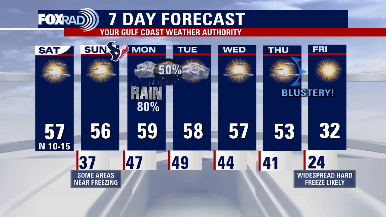
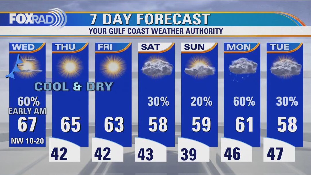
Good news for the last weekend before Christmas, which is always a busy one! Aside from seasonably cold temperatures, the weather will be quiet and cooperative. Monday is a washout pretty much start to finish, so allow for extra time to get around town. Midweek will be quiet, but a strong cold front will drag down a potent dose of arctic air on Thursday. Once we fall below freezing Thursday night, many locations may not rise above that until Saturday afternoon. Think ahead and begin hard freeze preps now, especially if you'll be out of town during that time period.
Good news for the last weekend before Christmas, which is always a busy one! Aside from seasonably cold temperatures, the weather will be quiet and cooperative. Monday is a washout pretty much start to finish, so allow for extra time to get around town. Midweek will be quiet, but a strong cold front will drag down a potent dose of arctic air on Thursday. Once we fall below freezing Thursday night, many locations may not rise above that until Saturday afternoon. Think ahead and begin hard freeze preps now, especially if you'll be out of town during that time period.


ERCOT "monitoring the forecast closely"; Arctic blast of cold air expected in Houston
Many people across the Houston area are already starting to prepare for a deep winter freeze expected late next week.
Many people across the Houston area are already starting to prepare for a deep winter freeze expected late next week.

Saturday morning weather forecast
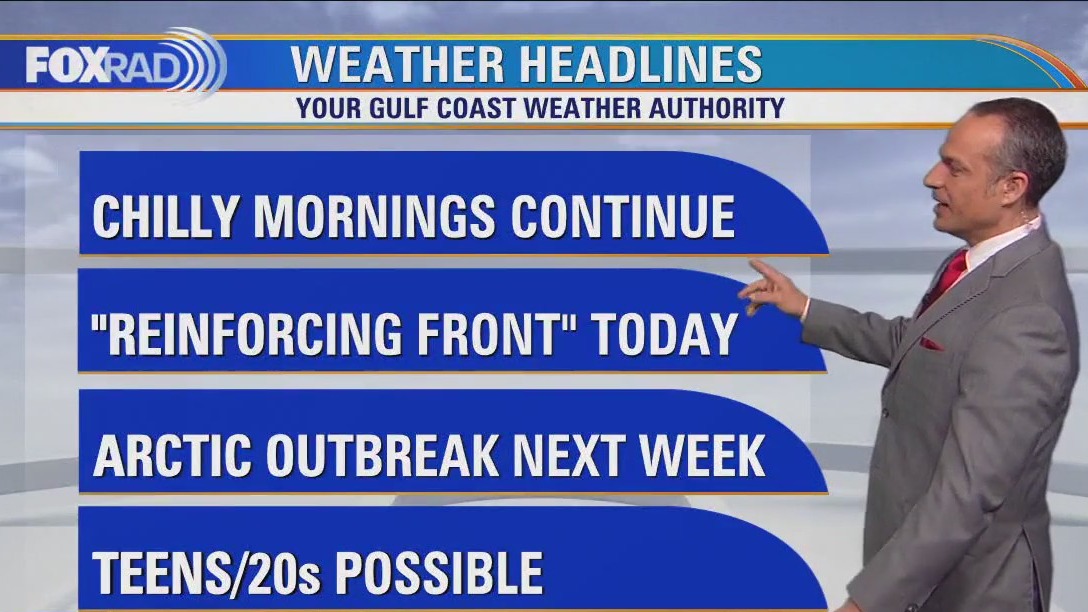
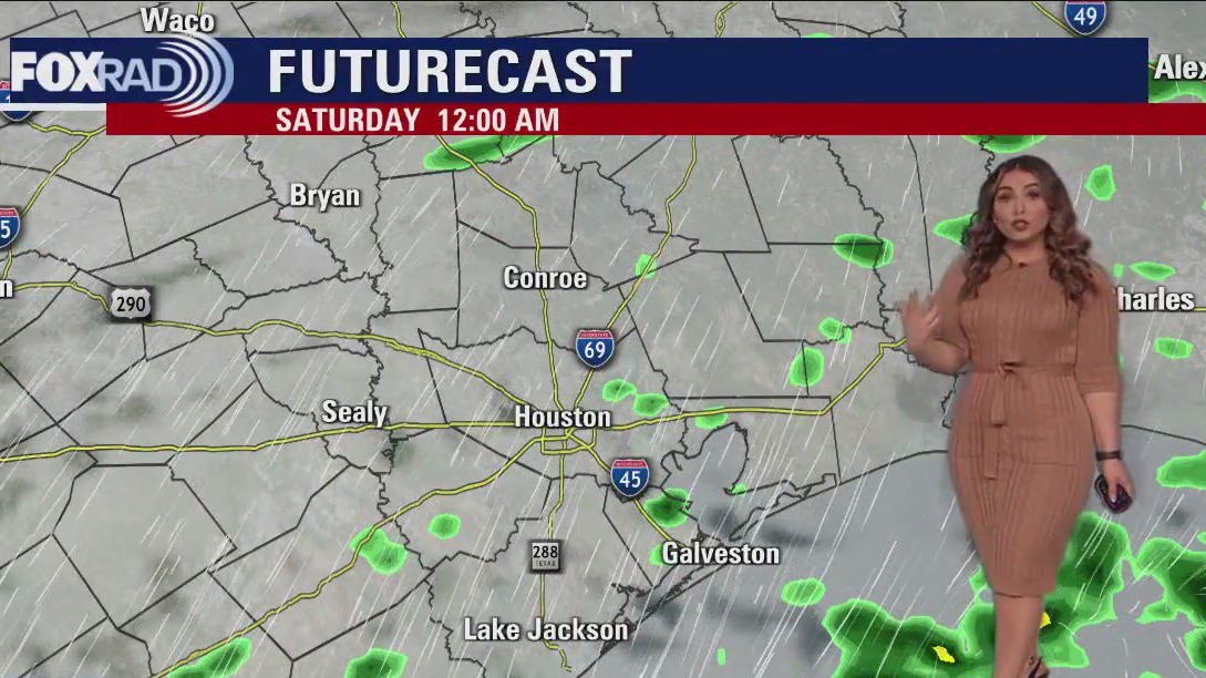
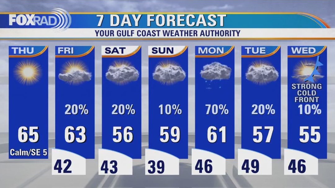
Spotty rain is possible this evening and tonight as a reinforcing front moves through the area. Rain should taper off tonight with just a slim shot for an isolated shower over the weekend. It will be cooler this weekend with highs in the 50s and overnight lows in the 30s and 40s. In fact, some of you may get close to freezing by Sunday morning. At least the weekend is mainly dry before widespread rain returns for Monday. Big story next week leading up to Christmas will be the major cold blast expected with a strong front Thursday. That means a widespread hard freeze likely by next Friday morning and temps about 30 degrees below normal Friday afternoon! Prepare now for the expected freezing conditions! Protect your pipes, plants, pets and of course yourself and loved ones!
Spotty rain is possible this evening and tonight as a reinforcing front moves through the area. Rain should taper off tonight with just a slim shot for an isolated shower over the weekend. It will be cooler this weekend with highs in the 50s and overnight lows in the 30s and 40s. In fact, some of you may get close to freezing by Sunday morning. At least the weekend is mainly dry before widespread rain returns for Monday. Big story next week leading up to Christmas will be the major cold blast expected with a strong front Thursday. That means a widespread hard freeze likely by next Friday morning and temps about 30 degrees below normal Friday afternoon! Prepare now for the expected freezing conditions! Protect your pipes, plants, pets and of course yourself and loved ones!

Cool, with a few showers Friday evening in the 60s
Spotty rain is possible this evening and tonight as a reinforcing front moves through the area. Rain should taper off tonight with just a slim shot for an isolated shower over the weekend. It will be cooler this weekend with highs in the 50s and overnight lows in the 30s and 40s. In fact, some of you may get close to freezing by Sunday morning. At least the weekend is mainly dry before widespread rain returns for Monday. Big story next week leading up to Christmas will be the major cold blast expected with a strong front Thursday. That means a widespread hard freeze likely by next Friday morning and temps about 30 degrees below normal Friday afternoon! Prepare now for the expected freezing conditions! Protect your pipes, plants, pets, and of course yourself and loved ones!
Spotty rain is possible this evening and tonight as a reinforcing front moves through the area. Rain should taper off tonight with just a slim shot for an isolated shower over the weekend. It will be cooler this weekend with highs in the 50s and overnight lows in the 30s and 40s. In fact, some of you may get close to freezing by Sunday morning. At least the weekend is mainly dry before widespread rain returns for Monday. Big story next week leading up to Christmas will be the major cold blast expected with a strong front Thursday. That means a widespread hard freeze likely by next Friday morning and temps about 30 degrees below normal Friday afternoon! Prepare now for the expected freezing conditions! Protect your pipes, plants, pets, and of course yourself and loved ones!


ERCOT closely monitoring changing weather conditions
ERCOT said they are closely monitoring weather forecasts and models as cold fronts begin to approach the Lone Star State.
ERCOT said they are closely monitoring weather forecasts and models as cold fronts begin to approach the Lone Star State.
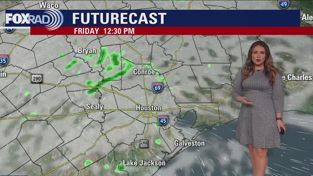

Cloudy Friday afternoon with light, spotty showers
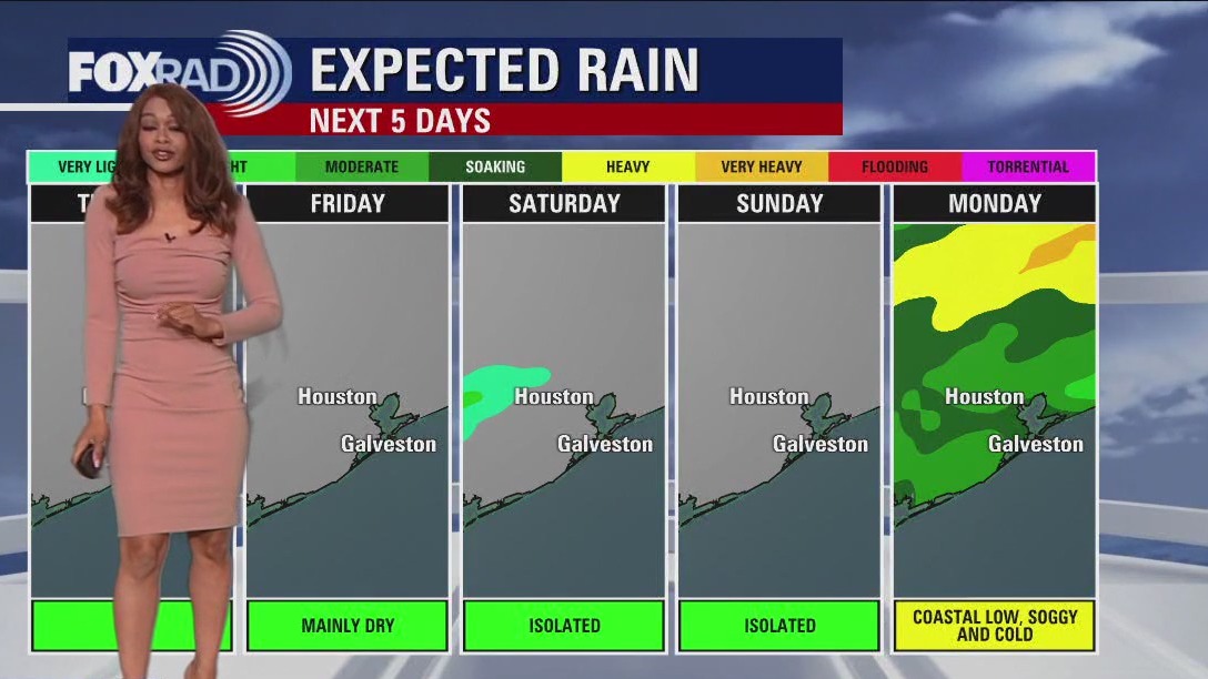
A few showers will be around tonight into tomorrow, and then the weekend is looking mostly dry but chilly. Sunday morning will be cold, keep that in mind if you'll be tailgating for the Texans or out and about early. Late Sunday through early Tuesday widespread rain is expected as a coastal low move across the area. Then get ready for a serious dose of cold air behind our next front, which will be dry but strong enough to pull in a blustery shot of north pole air just in time for Christmas.
A few showers will be around tonight into tomorrow, and then the weekend is looking mostly dry but chilly. Sunday morning will be cold, keep that in mind if you'll be tailgating for the Texans or out and about early. Late Sunday through early Tuesday widespread rain is expected as a coastal low move across the area. Then get ready for a serious dose of cold air behind our next front, which will be dry but strong enough to pull in a blustery shot of north pole air just in time for Christmas.

Friday weather forecast
Our weather is going to give us a bumpy ride over the next two weeks, so get ready. Watch for a few light showers today and tomorrow with seasonably cool temps. Some areas could reach the low 30s Sunday morning. Monday looks like a washout, then we turn our attention to an arctic blast that will move into the US for the middle of next week which could bring us the coldest air since the big freeze of 2021.
Our weather is going to give us a bumpy ride over the next two weeks, so get ready. Watch for a few light showers today and tomorrow with seasonably cool temps. Some areas could reach the low 30s Sunday morning. Monday looks like a washout, then we turn our attention to an arctic blast that will move into the US for the middle of next week which could bring us the coldest air since the big freeze of 2021.

Friday morning weather forecast
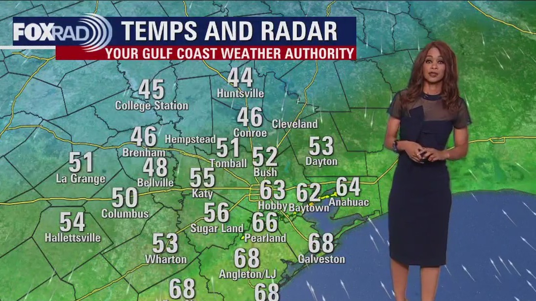
Weather looks cool and dry tonight with most areas dipping to the 40s and 50s closer to the coast. A few temperature readings in the 30s can't be ruled out up north. Friday looks pleasant by the afternoon with highs in the 60s. Weekend will be cool with just isolated showers. But look for a coastal low to bring widespread rain on Monday. Much stronger cold front arrives late next week by Thursday that will send temperatures plummeting just in time for the Christmas. First widespread freeze of the season is likely coming next Thursday night! Get ready!
Weather looks cool and dry tonight with most areas dipping to the 40s and 50s closer to the coast. A few temperature readings in the 30s can't be ruled out up north. Friday looks pleasant by the afternoon with highs in the 60s. Weekend will be cool with just isolated showers. But look for a coastal low to bring widespread rain on Monday. Much stronger cold front arrives late next week by Thursday that will send temperatures plummeting just in time for the Christmas. First widespread freeze of the season is likely coming next Thursday night! Get ready!


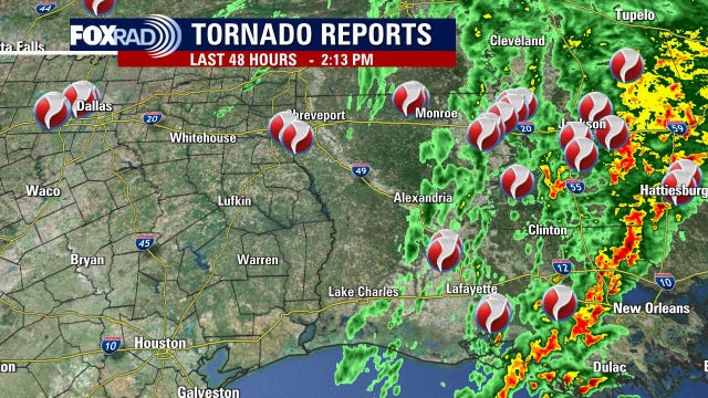
'God laid over top of us': Woman recounts terror she felt as Louisiana tornado killed neighbors
An EF-2 tornado with winds estimated at 130 mph managed to decimate homes around Linda Barry as she huddled under a mattress protected by her soon-to-be husband, reciting the Lord’s Prayer for comfort.
An EF-2 tornado with winds estimated at 130 mph managed to decimate homes around Linda Barry as she huddled under a mattress protected by her soon-to-be husband, reciting the Lord’s Prayer for comfort.

Calm, quiet, but oh-so chilly Thursday evening
Weather looks cool and dry tonight with most areas dipping to the 40s and 50s closer to the coast. A few temperature readings in the 30s can't be ruled out up north. Friday looks pleasant by the afternoon with highs in the 60s. Weekend will be cool with just isolated showers. But look for a coastal low to bring widespread rain on Monday. Much stronger cold front arrives late next week by Thursday that will send temperatures plummeting just in time for the Christmas. First widespread freeze of the season is likely coming next Thursday night! Get ready!
Weather looks cool and dry tonight with most areas dipping to the 40s and 50s closer to the coast. A few temperature readings in the 30s can't be ruled out up north. Friday looks pleasant by the afternoon with highs in the 60s. Weekend will be cool with just isolated showers. But look for a coastal low to bring widespread rain on Monday. Much stronger cold front arrives late next week by Thursday that will send temperatures plummeting just in time for the Christmas. First widespread freeze of the season is likely coming next Thursday night! Get ready!


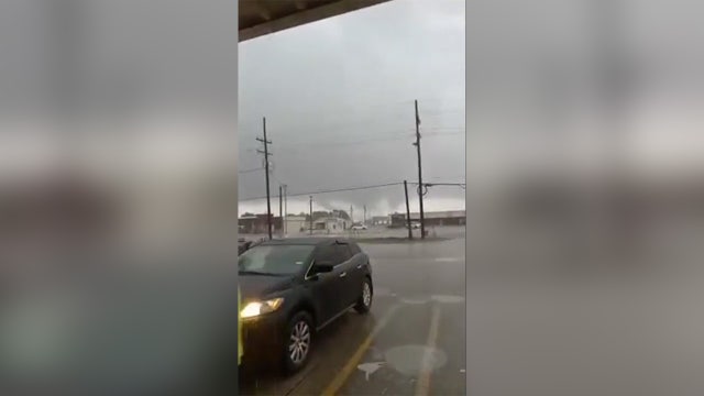
At least 3 people dead after tornadoes tore through Southeast Texas
Deadly tornadoes tore through Southeast Texas, killing at least three people and injuring others. FOX's Rebekah Castor has a live look at the devastation the tornadoes caused in Marrero, Louisiana.
Deadly tornadoes tore through Southeast Texas, killing at least three people and injuring others. FOX's Rebekah Castor has a live look at the devastation the tornadoes caused in Marrero, Louisiana.
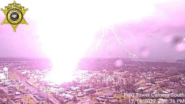

Stunning strike: Sheriff's office captures video of lightning bolt hitting lot in Louisiana
The perfectly-timed recording came as severe weather, including violent tornadoes, was moving across the region. Tornadoes killed at least three people in Louiaiana on Tuesday and Wednesday.
The perfectly-timed recording came as severe weather, including violent tornadoes, was moving across the region. Tornadoes killed at least three people in Louiaiana on Tuesday and Wednesday.

Cool, chilly Thursday afternoon in the 60s
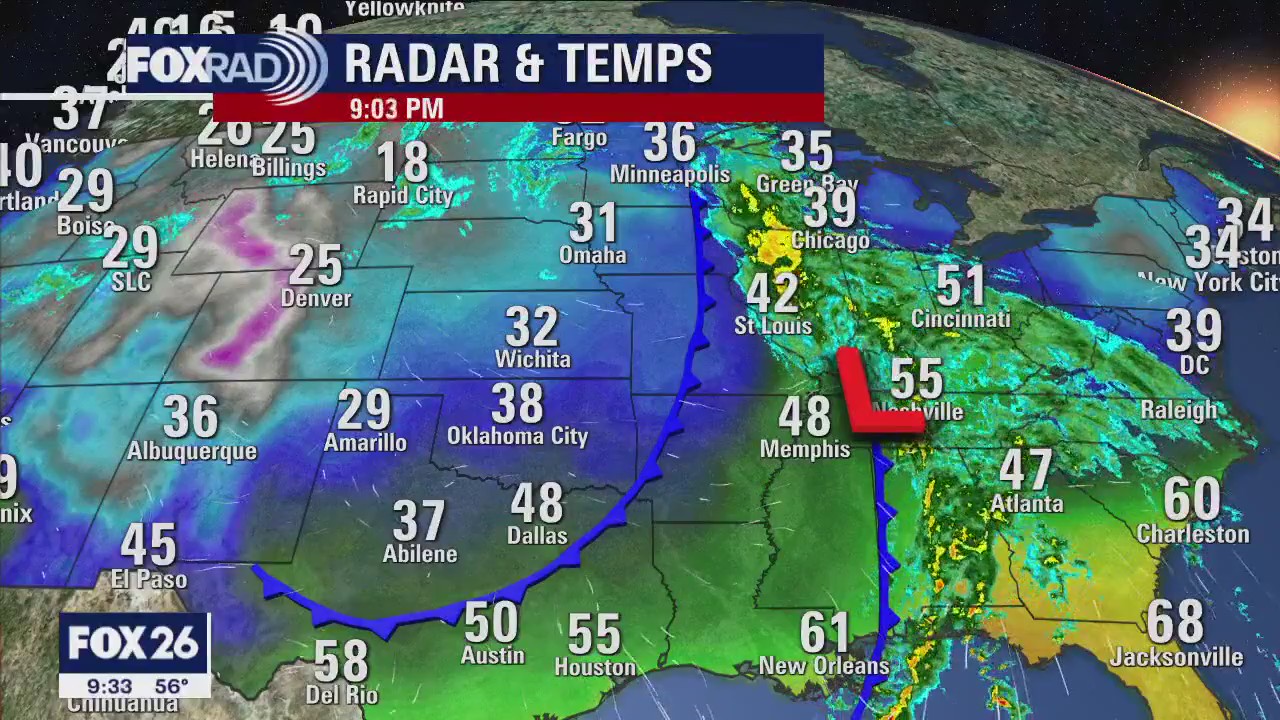
Cold mornings and cool afternoons will be the norm across southeast Texas this week. It will be good practice for the next shot of colder air that will drain in behind a stronger front late next week. Plan for a very chilly Christmas locally! Sunday night through Tuesday morning also looks fairly soggy, with a steady blanket of light to moderate rain courtesy of a coastal low. A few light and spotty showers are also possible overnight Friday as we head into the weekend, but the afternoons look mostly dry if you'll be out and about!
Cold mornings and cool afternoons will be the norm across southeast Texas this week. It will be good practice for the next shot of colder air that will drain in behind a stronger front late next week. Plan for a very chilly Christmas locally! Sunday night through Tuesday morning also looks fairly soggy, with a steady blanket of light to moderate rain courtesy of a coastal low. A few light and spotty showers are also possible overnight Friday as we head into the weekend, but the afternoons look mostly dry if you'll be out and about!

Clear and cold Thursday morning, then sunny, cool and dry
Seasonable December air has arrived in Houston and it looks like even colder air is on the way just before Christmas. Today looks nice with cool, dry air and highs in the 60s. Clouds return Friday through the weekend with chilly highs below 60 inland. Next week, there's a good chance for a blast of cold, windy weather for the days leading up to Christmas. The first widespread freeze of the season is likely.
Seasonable December air has arrived in Houston and it looks like even colder air is on the way just before Christmas. Today looks nice with cool, dry air and highs in the 60s. Clouds return Friday through the weekend with chilly highs below 60 inland. Next week, there's a good chance for a blast of cold, windy weather for the days leading up to Christmas. The first widespread freeze of the season is likely.

Thursday morning weather forecast
A big change in the weather pattern has finally found its way to Southeast Texas. Houston should see average to below average temperatures for the next 10-12 days. Thursday and Friday will be downright splendid for December days in Houston. Look for clear skies with mornings in the mid 40s and afternoons in the mid 60s. The weekend could see a few showers across the area as Gulf moisture tries to move back into the region. Look for higher rain chances on Monday.
A big change in the weather pattern has finally found its way to Southeast Texas. Houston should see average to below average temperatures for the next 10-12 days. Thursday and Friday will be downright splendid for December days in Houston. Look for clear skies with mornings in the mid 40s and afternoons in the mid 60s. The weekend could see a few showers across the area as Gulf moisture tries to move back into the region. Look for higher rain chances on Monday.


Tornado strikes New Orleans metro; damage surveys underway
About an hour after a violent tornado damaged a hospital and homes in New Iberia, the severe weather threat moved into the New Orleans metro area. The multi-day severe weather event has produced tornadoes from Texas to Louisiana.
About an hour after a violent tornado damaged a hospital and homes in New Iberia, the severe weather threat moved into the New Orleans metro area. The multi-day severe weather event has produced tornadoes from Texas to Louisiana.

3 killed in Louisiana as severe storms tear across South
One person died in Killona, Louisiana on Wednesday after a possible tornado swept through the area. A mother and child died on Tuesday after a tornado hit Keithville.
One person died in Killona, Louisiana on Wednesday after a possible tornado swept through the area. A mother and child died on Tuesday after a tornado hit Keithville.

Breezy Wednesday evening in the 60s with clear skies
A big change in the weather pattern has finally found its way to Southeast Texas. Houston should see average to below-average temperatures for the next 10-12 days. Thursday and Friday will be downright splendid for December days in Houston. Look for clear skies with mornings in the mid-40s and afternoons in the mid-60s. The weekend could see a few showers across the area as Gulf moisture tries to move back into the region. Look for higher rain chances on Monday.
A big change in the weather pattern has finally found its way to Southeast Texas. Houston should see average to below-average temperatures for the next 10-12 days. Thursday and Friday will be downright splendid for December days in Houston. Look for clear skies with mornings in the mid-40s and afternoons in the mid-60s. The weekend could see a few showers across the area as Gulf moisture tries to move back into the region. Look for higher rain chances on Monday.

Houston sees cooler weather appropriate for December at last
Bring on the cooler, December-appropriate temperatures after multiple days in the 80s in Houston.
Bring on the cooler, December-appropriate temperatures after multiple days in the 80s in Houston.

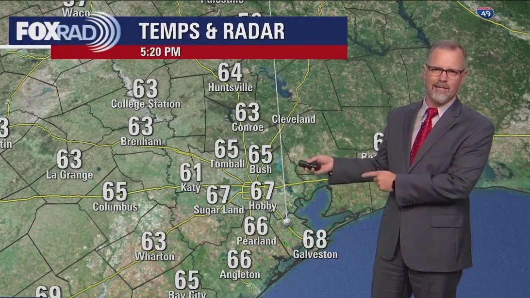
After Wednesday morning rain, cold front brings clear, dry, cooler weather
After early morning rain, a cold front will bring clear, very dry and cooler weather. Look for afternoon sun with breezy northwest winds today. Lows over the next several nights will drop to the upper 30s and low 40s with highs in the mid 60s. The pattern through Christmas still looks cold.
After early morning rain, a cold front will bring clear, very dry and cooler weather. Look for afternoon sun with breezy northwest winds today. Lows over the next several nights will drop to the upper 30s and low 40s with highs in the mid 60s. The pattern through Christmas still looks cold.