

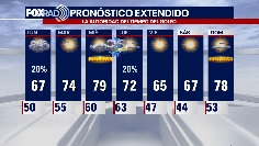

El Tiempo 8 de enero de 2023
#FOX26 Meteor?loga Lena Maria Arango tiene su pron?stico para la semana laboral.
#FOX26 Meteor?loga Lena Maria Arango tiene su pron?stico para la semana laboral.

Sunday weather forecast with Meteorologist Lena Maria Arango
Clouds will decrease throughout the day Sunday, leading to a pleasant afternoon. Monday, an area of low pressure will bring a few showers but most of it looks to stay offshore. We'll gradually warm through midweek, with Wednesday being another day where records may fall. An overnight front midweek brings more showers and storms, followed by a much cooler and drier area leading into the weekend.
Clouds will decrease throughout the day Sunday, leading to a pleasant afternoon. Monday, an area of low pressure will bring a few showers but most of it looks to stay offshore. We'll gradually warm through midweek, with Wednesday being another day where records may fall. An overnight front midweek brings more showers and storms, followed by a much cooler and drier area leading into the weekend.

Saturday evening weather forecast with Meteorologist John Dawson
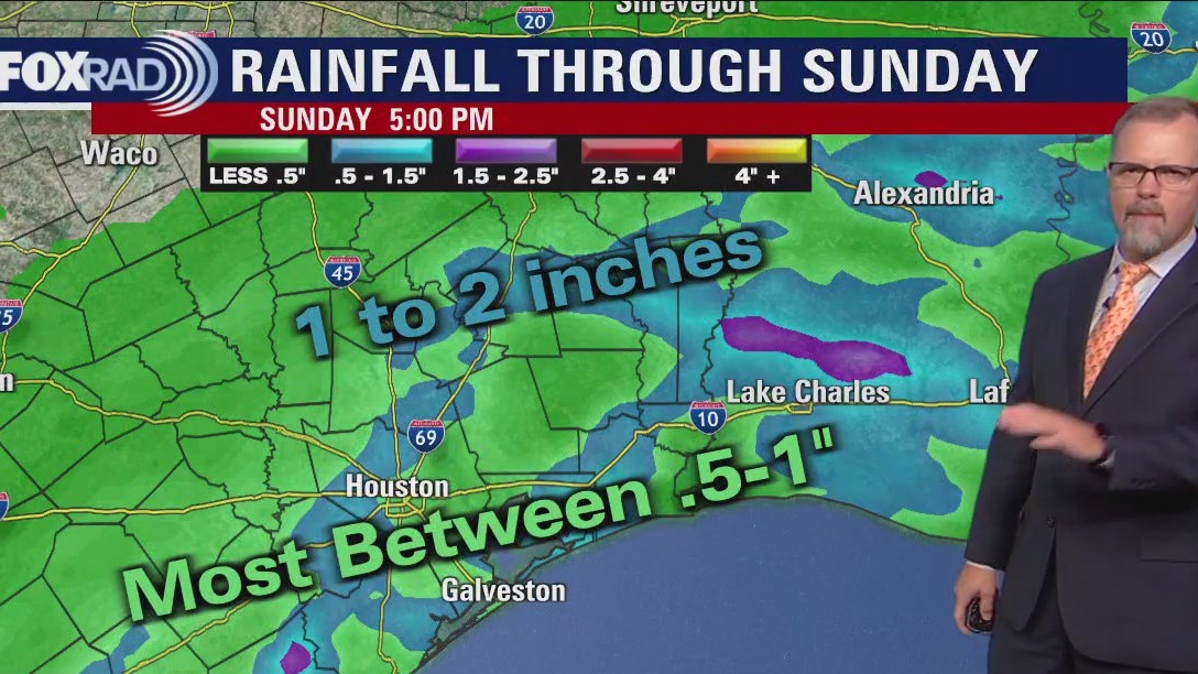
Showers and storms will continue across southeast Texas as a slow-moving cold front approaches the coast. Rain should start to break up around sunrise and skies start clearing around lunchtime. Clouds and a few showers will return to Houston on Monday. Look for mild temperatures to remain in the forecast for the next week.
Showers and storms will continue across southeast Texas as a slow-moving cold front approaches the coast. Rain should start to break up around sunrise and skies start clearing around lunchtime. Clouds and a few showers will return to Houston on Monday. Look for mild temperatures to remain in the forecast for the next week.
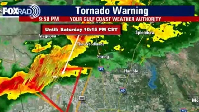

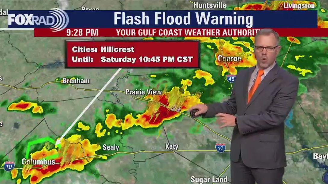
Houston Weather: Portion of southeast Texas under severe thunderstorm, tornado warning
Some areas around Houston are under Flash Flood Advisories. Northwest Harris County has been issued a Tornado Warning.
Some areas around Houston are under Flash Flood Advisories. Northwest Harris County has been issued a Tornado Warning.
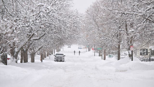

Where is the snow? US approaches midpoint of meteorological winter
January 14 serves as the midpoint of meteorological winter, which runs from December through February.
January 14 serves as the midpoint of meteorological winter, which runs from December through February.

Saturday weather forecast with Meteorologist Lena Maria Arango
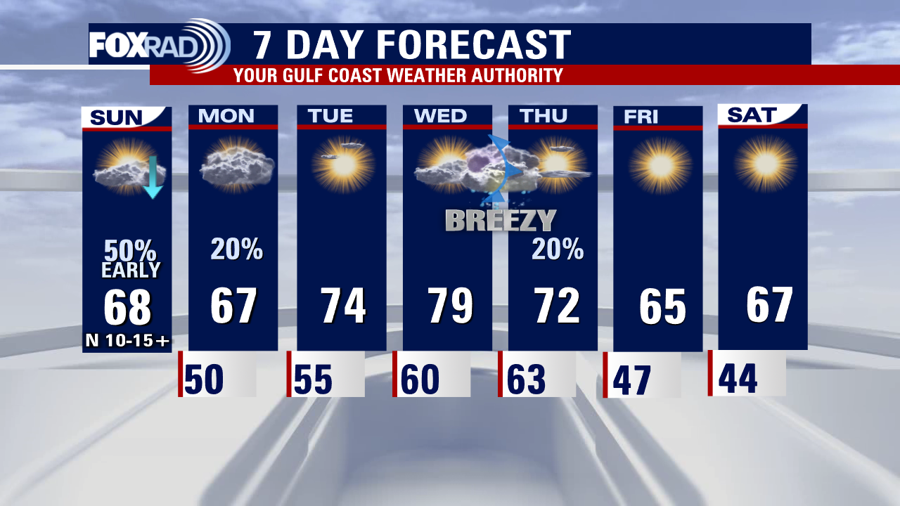
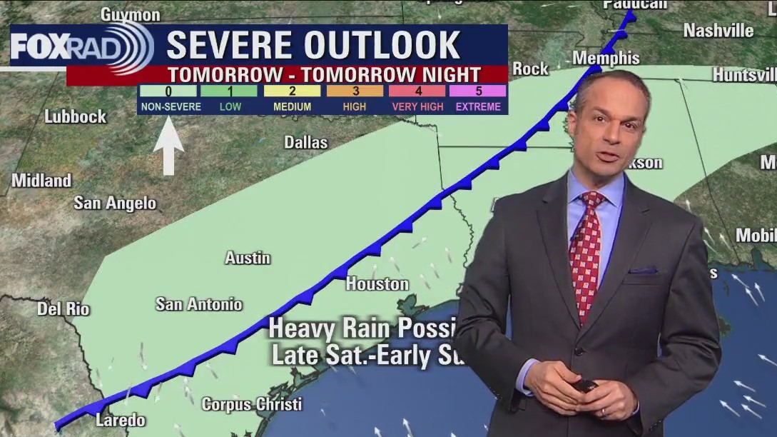
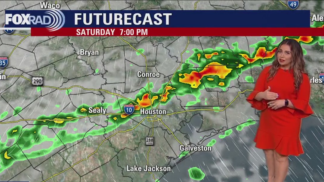
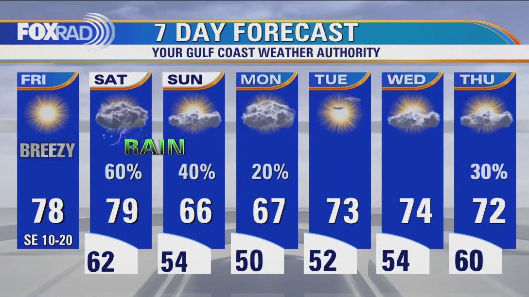
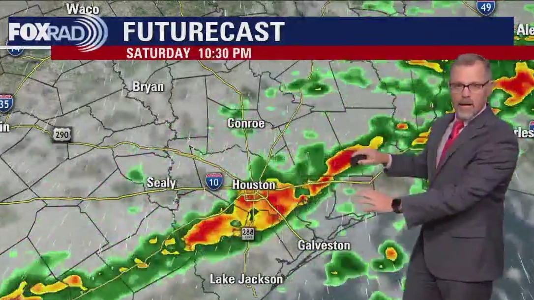
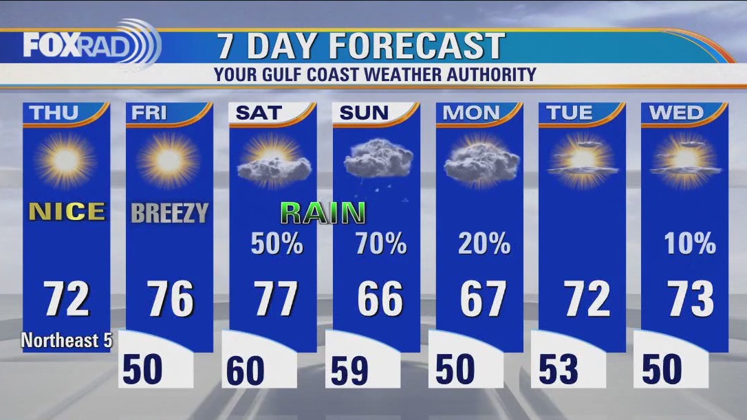
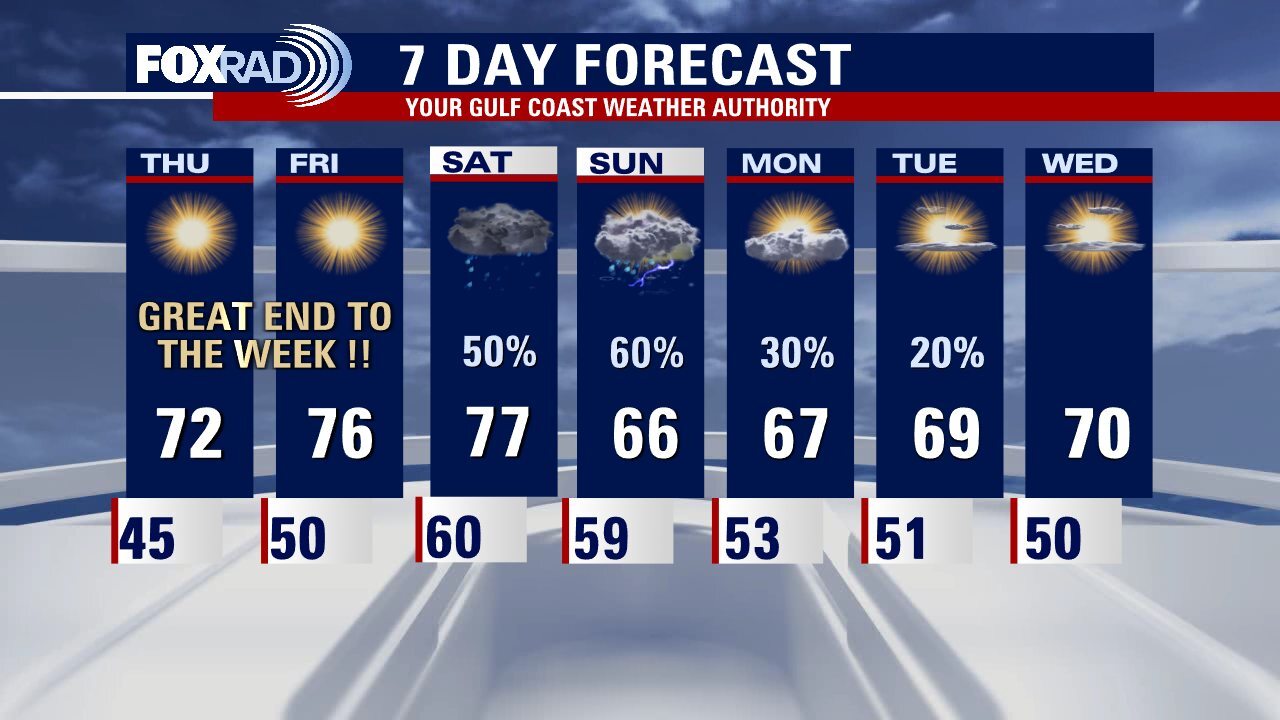
Saturday night features a low risk for strong to severe storms as a slow-moving front progresses across the area. The primary concerns are locally heavy rain, gusty winds, and maybe some hail. The front looks to clear the coastline by sunrise Sunday, leading to a much nicer end to the weekend. It is, however short-lived as a gulf disturbance brings the return of at least showers on Monday depending on how close to the coast it tracks. Sunshine and warmth will be sandwiched in between that, and another late week front that looks to bring a more promising cool-down.
Saturday night features a low risk for strong to severe storms as a slow-moving front progresses across the area. The primary concerns are locally heavy rain, gusty winds, and maybe some hail. The front looks to clear the coastline by sunrise Sunday, leading to a much nicer end to the weekend. It is, however short-lived as a gulf disturbance brings the return of at least showers on Monday depending on how close to the coast it tracks. Sunshine and warmth will be sandwiched in between that, and another late week front that looks to bring a more promising cool-down.

Saturday morning Houston-area forecast
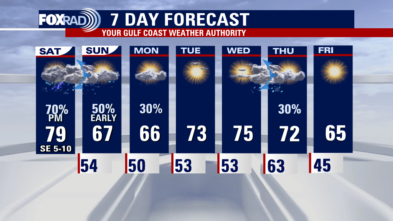
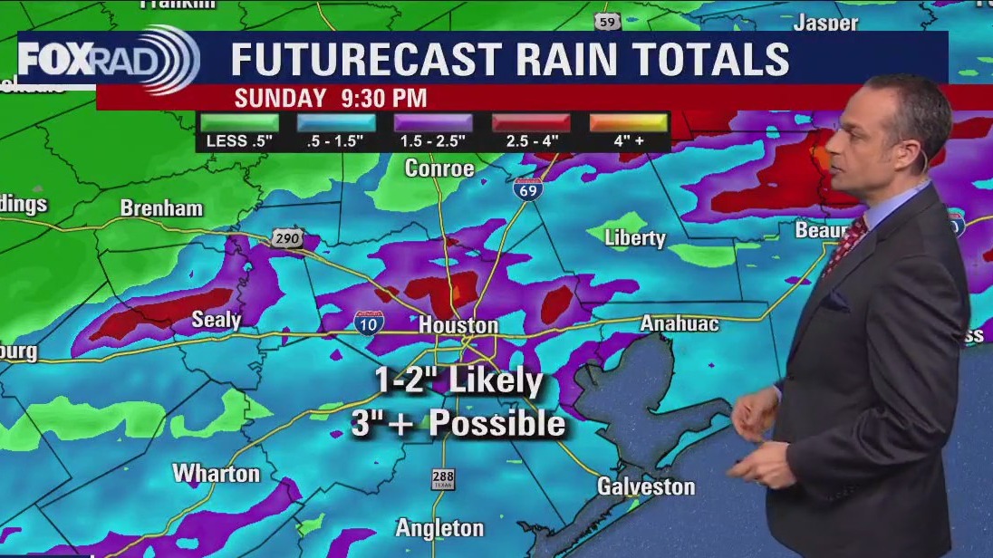
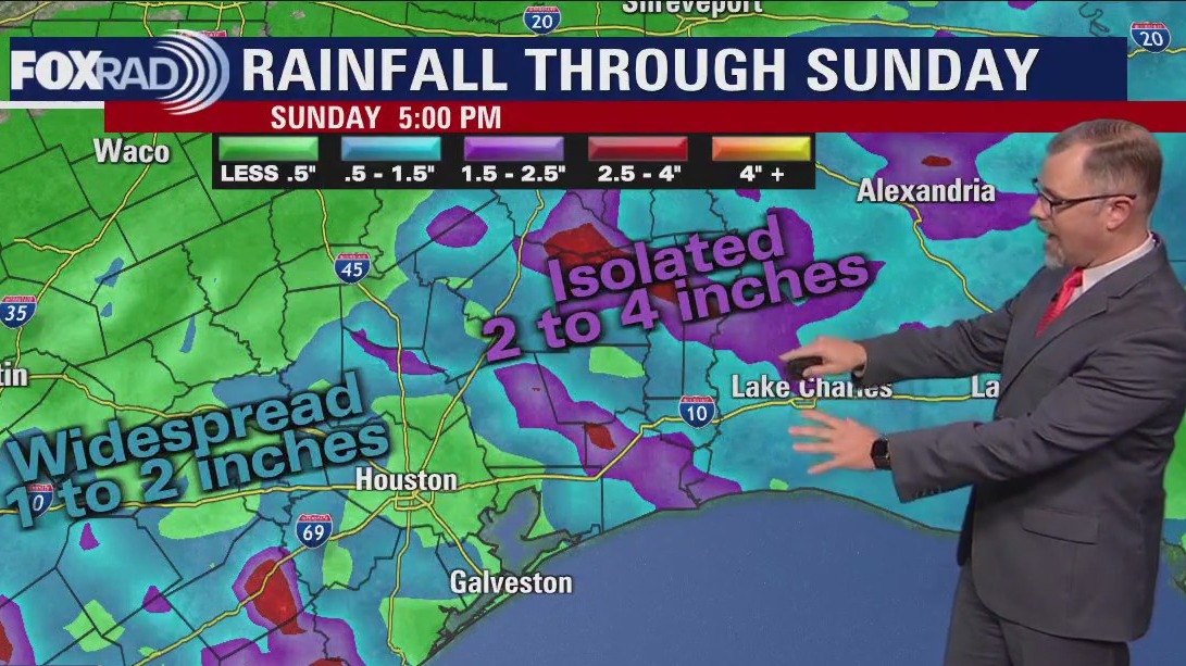
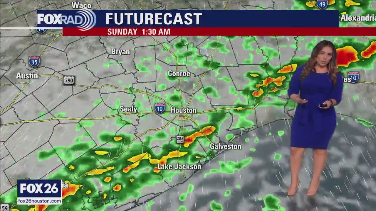
The weekend is here and just in time a front is going to bring a round of showers and storms. After some overnight and morning fog, the most likely timing for rain will be from Saturday afternoon through late morning Sunday. It looks like a scattering of showers and a few storms with potential for 1 to 2" of rain. A few spots could receive more, but overall, but a nice soaking. Next week, models are mixed on a quick round of showers on Monday, but overall the week looks fairly uneventful with cool nights and mild days.
The weekend is here and just in time a front is going to bring a round of showers and storms. After some overnight and morning fog, the most likely timing for rain will be from Saturday afternoon through late morning Sunday. It looks like a scattering of showers and a few storms with potential for 1 to 2" of rain. A few spots could receive more, but overall, but a nice soaking. Next week, models are mixed on a quick round of showers on Monday, but overall the week looks fairly uneventful with cool nights and mild days.

Clear skies Friday evening in the 70s with rain expected for the weekend
The weekend is here and just in time for a front is going to bring a round of showers and storms. After some overnight and morning fog, the most likely timing for rain will be from Saturday afternoon through late morning Sunday. It looks like a scattering of showers and a few storms with the potential for 1 to 2" of rain. A few spots could receive more, but overall, but a nice soaking. Next week, models are mixed on a quick round of showers on Monday, but overall the week looks fairly uneventful with cool nights and mild days.
The weekend is here and just in time for a front is going to bring a round of showers and storms. After some overnight and morning fog, the most likely timing for rain will be from Saturday afternoon through late morning Sunday. It looks like a scattering of showers and a few storms with the potential for 1 to 2" of rain. A few spots could receive more, but overall, but a nice soaking. Next week, models are mixed on a quick round of showers on Monday, but overall the week looks fairly uneventful with cool nights and mild days.

Warm, breezy Friday afternoon in the 70s
A glorious end to the work week, with abundant sunshine and increasing humidity that will have us flirting with record highs today and tomorrow. Scattered rain and storms are likely Saturday afternoon through Sunday morning as a front works its way through the area. A few other disturbances keep rain chances low, but in the forecast through Monday. Midweek looks warm and sunny, and another front may pass through Wednesday night into Thursday morning.
A glorious end to the work week, with abundant sunshine and increasing humidity that will have us flirting with record highs today and tomorrow. Scattered rain and storms are likely Saturday afternoon through Sunday morning as a front works its way through the area. A few other disturbances keep rain chances low, but in the forecast through Monday. Midweek looks warm and sunny, and another front may pass through Wednesday night into Thursday morning.

Houston weather: Cool start Friday, then breezy & warm this afternoon
A glorious end to the work week, with abundant sunshine and increasing humidity that will have us flirting with record highs today and tomorrow. Scattered rain and storms are likely Saturday afternoon through Sunday morning as a front works its way through the area. A few other disturbances keep rain chances low, but in the forecast through Monday. Midweek looks warm and sunny, and another front may pass through Wednesday night into Thursday morning.
A glorious end to the work week, with abundant sunshine and increasing humidity that will have us flirting with record highs today and tomorrow. Scattered rain and storms are likely Saturday afternoon through Sunday morning as a front works its way through the area. A few other disturbances keep rain chances low, but in the forecast through Monday. Midweek looks warm and sunny, and another front may pass through Wednesday night into Thursday morning.

Friday morning Houston-area weather forecast
Friday should be another beauty across Southeast Texas. The South wind will increase in the afternoon helping to add humidity around Houston. Showers and some thunderstorms will form as a front reaches the coast late on Saturday. Rain chances should hang around most of the day Sunday. A quiet pattern returns for the start of the work week.
Friday should be another beauty across Southeast Texas. The South wind will increase in the afternoon helping to add humidity around Houston. Showers and some thunderstorms will form as a front reaches the coast late on Saturday. Rain chances should hang around most of the day Sunday. A quiet pattern returns for the start of the work week.


El Tiempo 5 de enero de 2023
#FOX26 Meteor?loga Lena Maria Arango tiene su pron?stico para el fin de semana.
#FOX26 Meteor?loga Lena Maria Arango tiene su pron?stico para el fin de semana.

Clear skies Thursday evening in the 70s
Friday should be another beauty across Southeast Texas. The South wind will increase in the afternoon helping to add humidity around Houston. Showers and some thunderstorms will form as a front reaches the coast late on Saturday. Rain chances should hang around most of the day Sunday. A quiet pattern returns for the start of the work week.
Friday should be another beauty across Southeast Texas. The South wind will increase in the afternoon helping to add humidity around Houston. Showers and some thunderstorms will form as a front reaches the coast late on Saturday. Rain chances should hang around most of the day Sunday. A quiet pattern returns for the start of the work week.


Hurricane hunters fly missions to California to study atmospheric river amid powerful storm
It may not be hurricane season, but Air Force and NOAA aircraft are still busy collecting data over the Pacific from November to March.
It may not be hurricane season, but Air Force and NOAA aircraft are still busy collecting data over the Pacific from November to March.

Warm, pleasant Thursday afternoon in the 70s
Two more days of bliss, before cloud cover increases and rain chances go up. Won't be a total washout all weekend, but scattered showers and storms mainly in the latter part of Saturday into the early part of Sunday may interrupt your outdoor plans. We look to stay somewhat unsettled through early next week, with no major decrease in temperatures given that this front is coming from the Pacific rather than the north. Enjoy the mild January air!
Two more days of bliss, before cloud cover increases and rain chances go up. Won't be a total washout all weekend, but scattered showers and storms mainly in the latter part of Saturday into the early part of Sunday may interrupt your outdoor plans. We look to stay somewhat unsettled through early next week, with no major decrease in temperatures given that this front is coming from the Pacific rather than the north. Enjoy the mild January air!

Houston weather: Clear and chilly Thursday morning, then sunny, dry and mild
Enjoy another great day today with sunshine, low humidity and pleasant January highs near 70. A south breeze kicks in on Friday which will gradually bringing more humidity along with warmer temperatures. This weekend, a small ripple of the big Pacific storm system will help to bring a weak front and a high chance for showers and storms, especially late Saturday and early Sunday.
Enjoy another great day today with sunshine, low humidity and pleasant January highs near 70. A south breeze kicks in on Friday which will gradually bringing more humidity along with warmer temperatures. This weekend, a small ripple of the big Pacific storm system will help to bring a weak front and a high chance for showers and storms, especially late Saturday and early Sunday.

Thursday morning Houston-area weather forecast
The great weather continues for Southeast Texas to finish out the work week. Expect a breezy Friday as the next Pacific storm systems moves across the country, eventually increasing rain chances for Houston over the weekend. Don't look for a complete washout of a weekend but there will be some showers and isolated storms to dodge.
The great weather continues for Southeast Texas to finish out the work week. Expect a breezy Friday as the next Pacific storm systems moves across the country, eventually increasing rain chances for Houston over the weekend. Don't look for a complete washout of a weekend but there will be some showers and isolated storms to dodge.

Wednesday evening weather forecast with Meteorologist John Dawson
The great weather continues for Southeast Texas to finish out the work week. Expect a breezy Friday as the next Pacific storm system moves across the country, eventually increasing rain chances for Houston over the weekend. Don't look for a complete washout of a weekend but there will be some showers and isolated storms to dodge.
The great weather continues for Southeast Texas to finish out the work week. Expect a breezy Friday as the next Pacific storm system moves across the country, eventually increasing rain chances for Houston over the weekend. Don't look for a complete washout of a weekend but there will be some showers and isolated storms to dodge.


Moose rescued from frozen lake after being stuck for hours
Authorities in Washington state said the attempt to pull the moose to safety was a calculated decision.
Authorities in Washington state said the attempt to pull the moose to safety was a calculated decision.


Southwest’s weather data system suffers ‘brief outage’ prior to flights, causing delays
More than 1,600 Southwest flights were delayed Tuesday, while 140 were canceled.
More than 1,600 Southwest flights were delayed Tuesday, while 140 were canceled.