

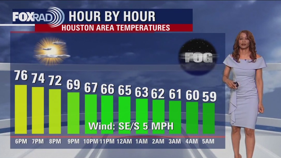

Houston weather: Foggy, but warm Thursday evening in the 70s
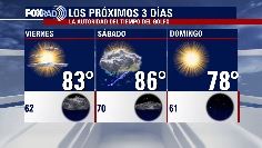
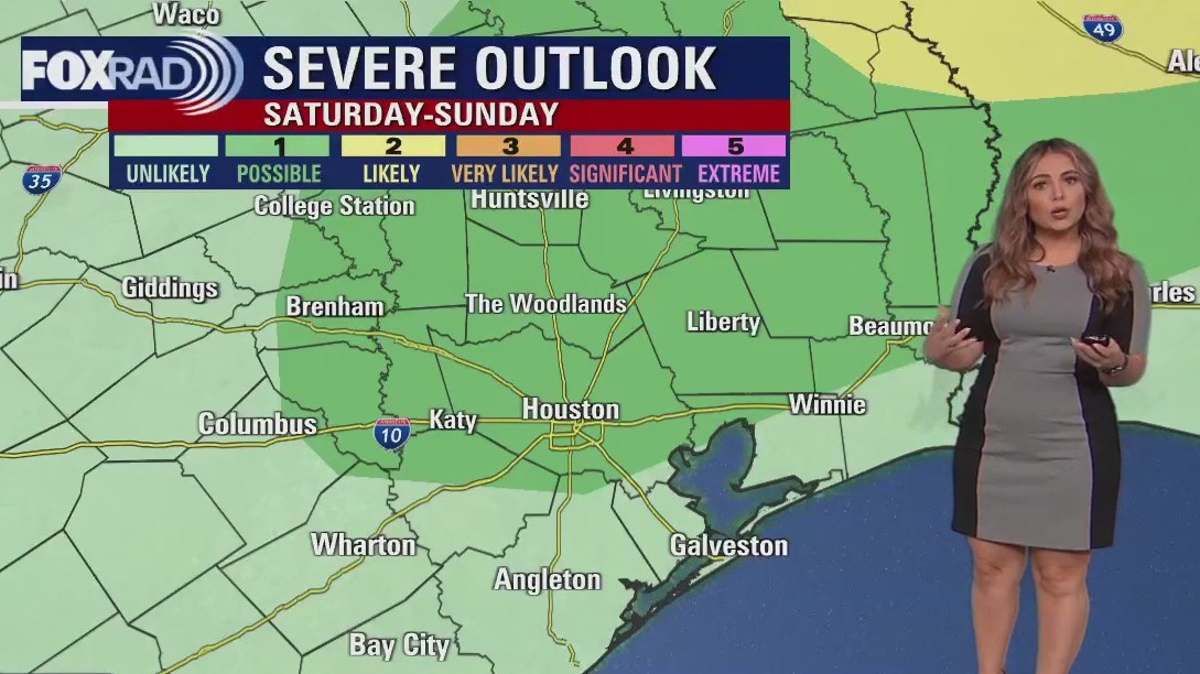
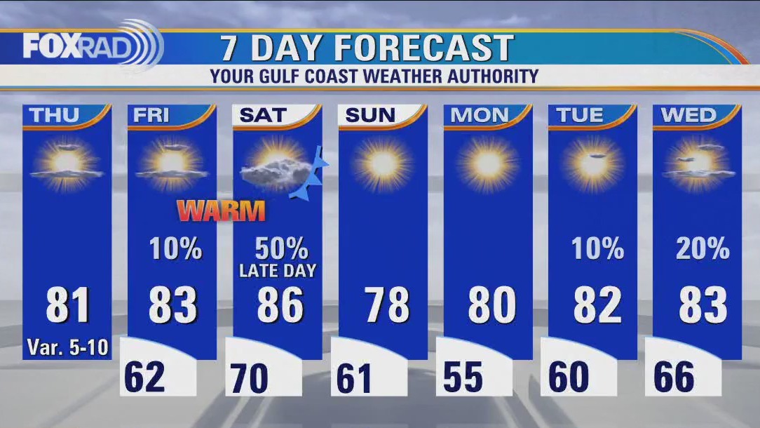
Weather stays pretty quiet for tonight other than some patchy fog that may develop late. Friday will be a warm day with only a 10% chance of an afternoon shower or storm, mainly NW of Houston. Temperatures will soar to the 80s both Friday and Saturday ahead of a cold front. That front will bring in a round of showers and storms Saturday afternoon and evening. There's a low threat of an isolated severe storm Saturday with damaging winds and hail the main threats. Some heavy downpours may send you indoors for a few hours Saturday evening. But once that front moves by, we dry out and quickly clear out making way for a pleasant and bright Sunday. Next week looks pretty quiet with low rain chances back Tuesday. But the heat will be building to the middle 80s by Thursday.
Weather stays pretty quiet for tonight other than some patchy fog that may develop late. Friday will be a warm day with only a 10% chance of an afternoon shower or storm, mainly NW of Houston. Temperatures will soar to the 80s both Friday and Saturday ahead of a cold front. That front will bring in a round of showers and storms Saturday afternoon and evening. There's a low threat of an isolated severe storm Saturday with damaging winds and hail the main threats. Some heavy downpours may send you indoors for a few hours Saturday evening. But once that front moves by, we dry out and quickly clear out making way for a pleasant and bright Sunday. Next week looks pretty quiet with low rain chances back Tuesday. But the heat will be building to the middle 80s by Thursday.

El Tiempo 13 de Abril de 2023
#FOX26 Meteor?loga Lena Maria Arango tiene su pron?stico para el fin de semana.
#FOX26 Meteor?loga Lena Maria Arango tiene su pron?stico para el fin de semana.

Houston weather: Colorado State University released Hurricane Season Outlook
Thursday will be sunny, bright and quiet. Tomorrow, expect winds to ramp up out of the south increasing humidity and that could spark a few brief stray showers in the afternoon. Saturday will start off Muggy, but an approaching front will change that in the evening. While daytime precipitation will be isolated, look out for downpours and a few stronger storms including gusty winds, and possibly hail mainly from 6-10pm. A few isolated storms may linger near the coast through midnight or just past, but the front will drop our humidity and we'll be back to pleasant, dry days Sunday through early next week!
Thursday will be sunny, bright and quiet. Tomorrow, expect winds to ramp up out of the south increasing humidity and that could spark a few brief stray showers in the afternoon. Saturday will start off Muggy, but an approaching front will change that in the evening. While daytime precipitation will be isolated, look out for downpours and a few stronger storms including gusty winds, and possibly hail mainly from 6-10pm. A few isolated storms may linger near the coast through midnight or just past, but the front will drop our humidity and we'll be back to pleasant, dry days Sunday through early next week!
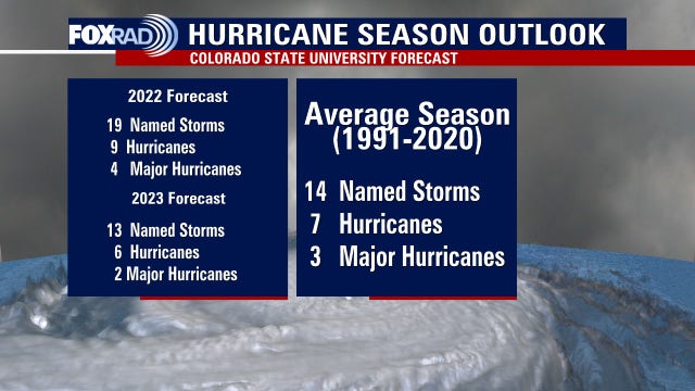

Colorado State University hurricane forecast: 2023 outlook released
What will the 2023 Atlantic Hurricane Season bring? Colorado State University just released their outlook. Here's what they are calling for.
What will the 2023 Atlantic Hurricane Season bring? Colorado State University just released their outlook. Here's what they are calling for.

Houston weather: Cool Thursday morning, then mostly sunny, warm and dry
We have a beautiful day ahead with dry air and pleasant temps. The only issue will be potential for dust, ozone and lots of pollen due to light and variable winds. A warming trend kicks in for Friday and Saturday with a line of storms possibly Saturday night. Following that front, we'll enjoy more sunshine and dry air to begin next week.
We have a beautiful day ahead with dry air and pleasant temps. The only issue will be potential for dust, ozone and lots of pollen due to light and variable winds. A warming trend kicks in for Friday and Saturday with a line of storms possibly Saturday night. Following that front, we'll enjoy more sunshine and dry air to begin next week.

Houston weather: Dry weather moving in, heat on the way
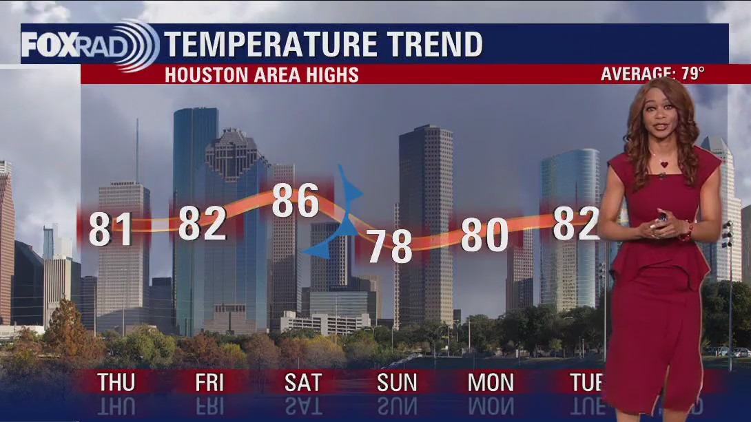
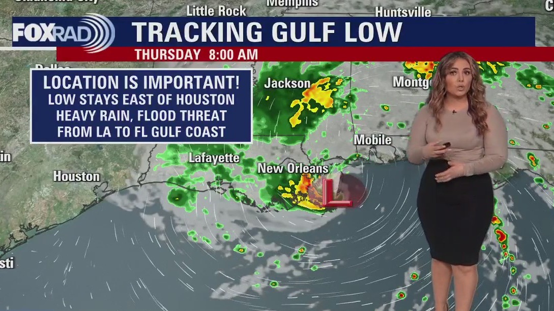
On Thursday, temperatures will soar to around 80 degrees. The surface low in the Gulf is not expected to become tropical, but will spread some heavy rain and increase the flood threat from the Louisiana Gulf Coast to the Florida Gulf Coast. We will not get any significant impacts from that system but watch out if you are traveling east. Look for a few warm and mainly dry days Thursday and Friday as temps soar to the low to middle 80s Friday afternoon. Next cold front arrives Saturday evening bringing with it a chance for showers and storms. Second half of the weekend looks beautiful and bright!
On Thursday, temperatures will soar to around 80 degrees. The surface low in the Gulf is not expected to become tropical, but will spread some heavy rain and increase the flood threat from the Louisiana Gulf Coast to the Florida Gulf Coast. We will not get any significant impacts from that system but watch out if you are traveling east. Look for a few warm and mainly dry days Thursday and Friday as temps soar to the low to middle 80s Friday afternoon. Next cold front arrives Saturday evening bringing with it a chance for showers and storms. Second half of the weekend looks beautiful and bright!
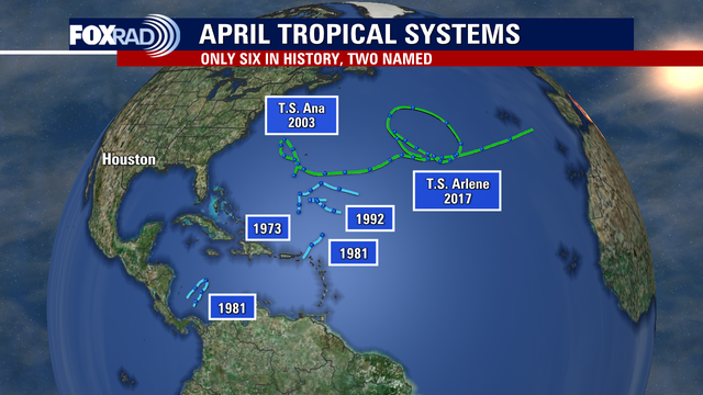

Historic storm could form in the Gulf of Mexico this week; earliest named storm since 2017
According to National Hurricane Center records, only two named tropical systems occurred in April - Ana in 2003 and Arlene in 2017. Neither of those tropical storms impacted land as Ana made a long trek across the Atlantic Ocean away from the United States and Arlene simply spun around the central Atlantic for one day.
According to National Hurricane Center records, only two named tropical systems occurred in April - Ana in 2003 and Arlene in 2017. Neither of those tropical storms impacted land as Ana made a long trek across the Atlantic Ocean away from the United States and Arlene simply spun around the central Atlantic for one day.

Sunny, mild Wednesday afternoon in the 70s
Today will be mostly sunny and mild, with a few pop-up showers or storms on the outer edges of an unusual area of low pressure impacting other Gulf states that we've been monitoring and talking about for days. While we will barely feel any impacts locally, rain and possibly a few strong storms look to make a reappearance late Saturday into early Sunday as a cold front moves through. Then, it's back to pleasant and dry weather at the start of next week.
Today will be mostly sunny and mild, with a few pop-up showers or storms on the outer edges of an unusual area of low pressure impacting other Gulf states that we've been monitoring and talking about for days. While we will barely feel any impacts locally, rain and possibly a few strong storms look to make a reappearance late Saturday into early Sunday as a cold front moves through. Then, it's back to pleasant and dry weather at the start of next week.

Houston weather: Partly cloudy and mild Wednesday with isolated afternoon storms
While we continue to watch an unusual low forming south of New Orleans, our weather will only be affected in a small way - mostly with a chance for scattered afternoon showers today. Otherwise, our forecast looks great for the rest of this week with pleasant low temperatures in the 50s and 60s along with highs in the 70s and 80s. Moisture increases on Saturday followed by a late-day front that could bring a round of storms leaving behind a great outlook for Sunday.
While we continue to watch an unusual low forming south of New Orleans, our weather will only be affected in a small way - mostly with a chance for scattered afternoon showers today. Otherwise, our forecast looks great for the rest of this week with pleasant low temperatures in the 50s and 60s along with highs in the 70s and 80s. Moisture increases on Saturday followed by a late-day front that could bring a round of storms leaving behind a great outlook for Sunday.


Wednesday morning Houston-weather forecast
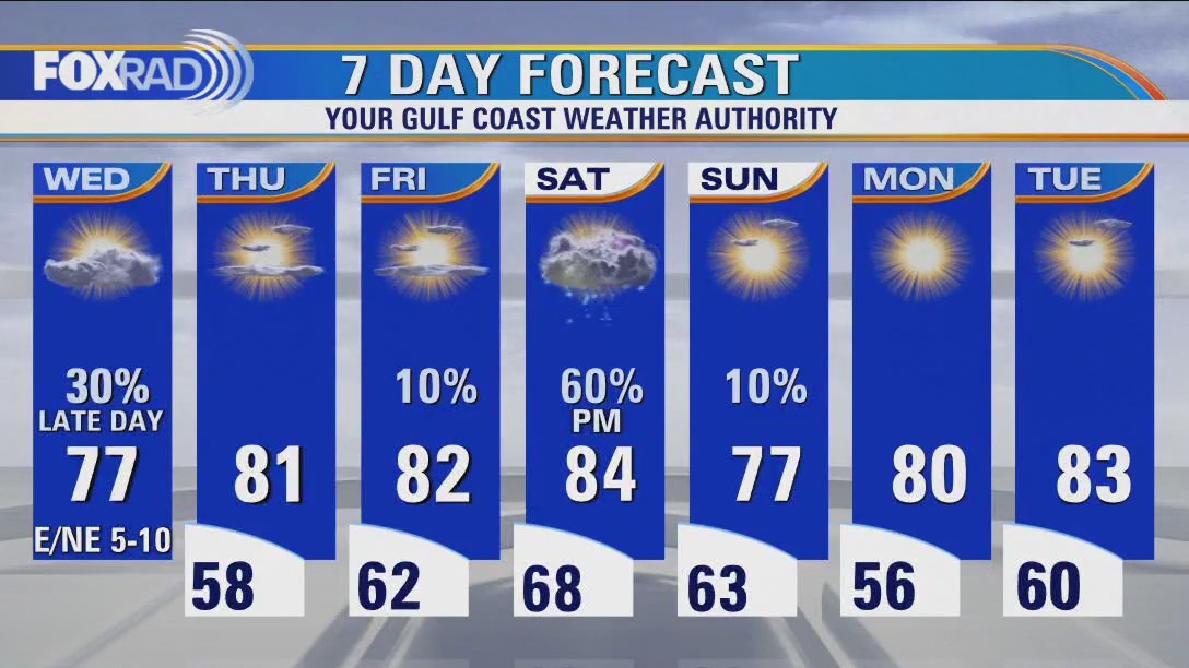
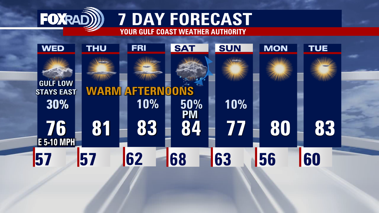
Wednesday will be a comfortable day with temperatures climbing to the 70s. A few showers and storms might form, especially in our eastern counties. We'll be watching the Gulf of Mexico for a possible surface low that could develop just south of the Louisiana gulf coast. The area of low pressure will likely not become tropical, but could become subtropical as it develops over the next 24-36 hours. Regardless of being tropical or not, the low will spread some heavy rain from Louisiana to the Florida coast. Coastal flooding will be possible in some of these locations. For the Houston area, we will stay on the western or drier side of the low. So other than a few showers and storms Wednesday, we will not be impacted much. We will heat up into the 80s heading into the weekend and wait for a strong cold front late Saturday that will bring a decent shot for showers and some strong storms.
Wednesday will be a comfortable day with temperatures climbing to the 70s. A few showers and storms might form, especially in our eastern counties. We'll be watching the Gulf of Mexico for a possible surface low that could develop just south of the Louisiana gulf coast. The area of low pressure will likely not become tropical, but could become subtropical as it develops over the next 24-36 hours. Regardless of being tropical or not, the low will spread some heavy rain from Louisiana to the Florida coast. Coastal flooding will be possible in some of these locations. For the Houston area, we will stay on the western or drier side of the low. So other than a few showers and storms Wednesday, we will not be impacted much. We will heat up into the 80s heading into the weekend and wait for a strong cold front late Saturday that will bring a decent shot for showers and some strong storms.

Tuesday evening weather forecast with Meteorologist Remeisha Shade
The weather tonight should be fairly quiet with pleasant temperatures in the upper 50s and just a slim shot for rain. Best shot for rain will be near the coast. Wednesday will be a comfortable day with temperatures climbing to the 70s. A few showers and storms might form, especially in our eastern counties. We'll be watching the Gulf of Mexico for a possible surface low that could develop just south of the Louisiana gulf coast. The area of low pressure will likely not become tropical but could become subtropical as it develops over the next 24-36 hours. Regardless of being tropical or not, the low will spread some heavy rain from Louisiana to the Florida coast. Coastal flooding will be possible in some of these locations. For the Houston area, we will stay on the western or drier side of the low. So other than a few showers and storms Wednesday, we will not be impacted much. We will heat up into the 80s heading into the weekend and wait for a strong cold front late Saturday that will bring a decent shot for showers and some strong storms.
The weather tonight should be fairly quiet with pleasant temperatures in the upper 50s and just a slim shot for rain. Best shot for rain will be near the coast. Wednesday will be a comfortable day with temperatures climbing to the 70s. A few showers and storms might form, especially in our eastern counties. We'll be watching the Gulf of Mexico for a possible surface low that could develop just south of the Louisiana gulf coast. The area of low pressure will likely not become tropical but could become subtropical as it develops over the next 24-36 hours. Regardless of being tropical or not, the low will spread some heavy rain from Louisiana to the Florida coast. Coastal flooding will be possible in some of these locations. For the Houston area, we will stay on the western or drier side of the low. So other than a few showers and storms Wednesday, we will not be impacted much. We will heat up into the 80s heading into the weekend and wait for a strong cold front late Saturday that will bring a decent shot for showers and some strong storms.
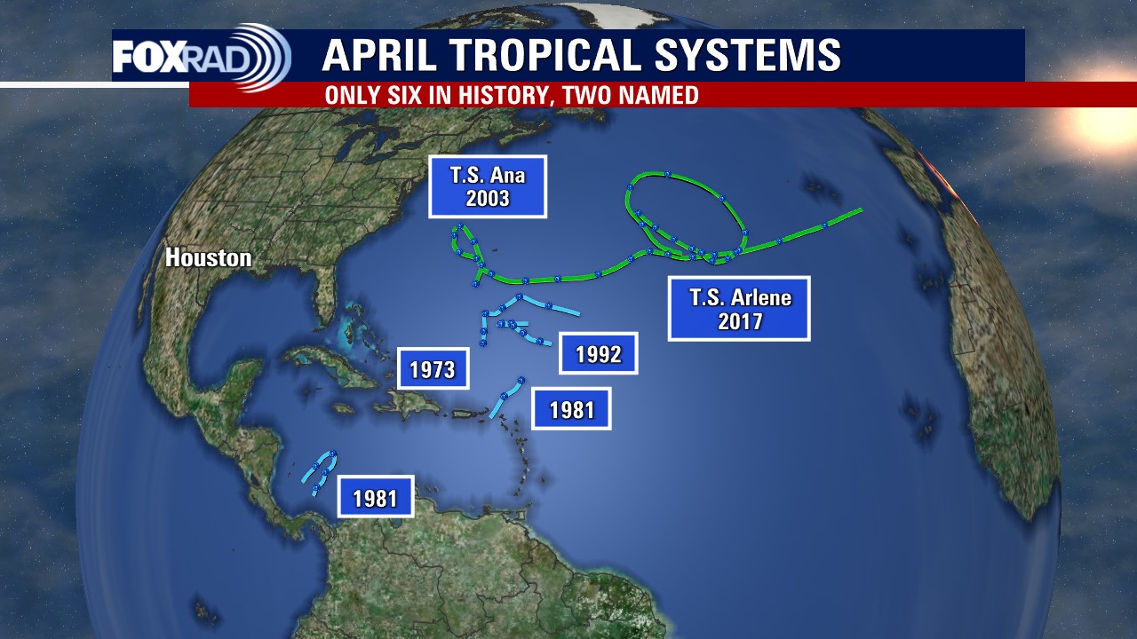

Rare tropic-like system could in the Gulf this week; earliest named storm since 2017
According to National Hurricane Center records, only two named tropical systems occurred in April - Ana in 2003 and Arlene in 2017. Neither of those tropical storms impacted land as Ana made a long trek across the Atlantic Ocean away from the United States and Arlene simply spun around the central Atlantic for one day.
According to National Hurricane Center records, only two named tropical systems occurred in April - Ana in 2003 and Arlene in 2017. Neither of those tropical storms impacted land as Ana made a long trek across the Atlantic Ocean away from the United States and Arlene simply spun around the central Atlantic for one day.


Houston weather: Flood warning issued for Tuesday and Wednesday
The warning was issued for Harris, Montgomery, and Liberty Counties until Wednesday, April 12.
The warning was issued for Harris, Montgomery, and Liberty Counties until Wednesday, April 12.

Houston weather: Cool Tuesday morning, then pleasant temps
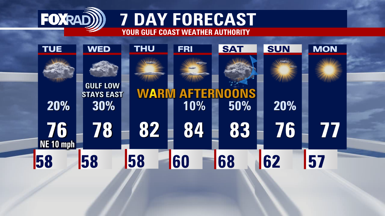
Overall, the rest of this week should be pretty quiet with cooler conditions early in the week and warmer temps with more humidity by Friday and Saturday. A front is expected late Saturday which could bring a round of storms. Other than that, an interesting low could form in the Gulf south of Louisiana that is unusually "tropical like" for April, but it's not likely to be a bug concern and will probably not affect Texas.
Overall, the rest of this week should be pretty quiet with cooler conditions early in the week and warmer temps with more humidity by Friday and Saturday. A front is expected late Saturday which could bring a round of storms. Other than that, an interesting low could form in the Gulf south of Louisiana that is unusually "tropical like" for April, but it's not likely to be a bug concern and will probably not affect Texas.
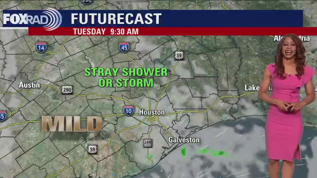

Tuesday morning Houston-area weather forecast
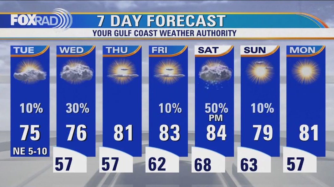
Tuesday's weather pattern will be similar with a 20% chance for showers and storms and temperatures climbing to the 70s. By Wednesday, we are expecting a surface low to develop in the north central Gulf of Mexico, just south of New Orleans. While it is not expected to become a tropical system, it could become subtropical and bring a big round of rain to the Louisiana Gulf coast. Fortunately, models project this low to stay to our SE which means we would be on the western side or drier side with no major impacts to Houston weather. There will be a slightly higher chance of showers and storms Wednesday (30%), especially for the eastern half of the area. By late week, we heat up ahead of our next cold front. Showers and some strong storms appear to be a good bet by Saturday evening with this next front. Look for widespread 80s Thursday through Saturday with cooler weather likely early next week.
Tuesday's weather pattern will be similar with a 20% chance for showers and storms and temperatures climbing to the 70s. By Wednesday, we are expecting a surface low to develop in the north central Gulf of Mexico, just south of New Orleans. While it is not expected to become a tropical system, it could become subtropical and bring a big round of rain to the Louisiana Gulf coast. Fortunately, models project this low to stay to our SE which means we would be on the western side or drier side with no major impacts to Houston weather. There will be a slightly higher chance of showers and storms Wednesday (30%), especially for the eastern half of the area. By late week, we heat up ahead of our next cold front. Showers and some strong storms appear to be a good bet by Saturday evening with this next front. Look for widespread 80s Thursday through Saturday with cooler weather likely early next week.

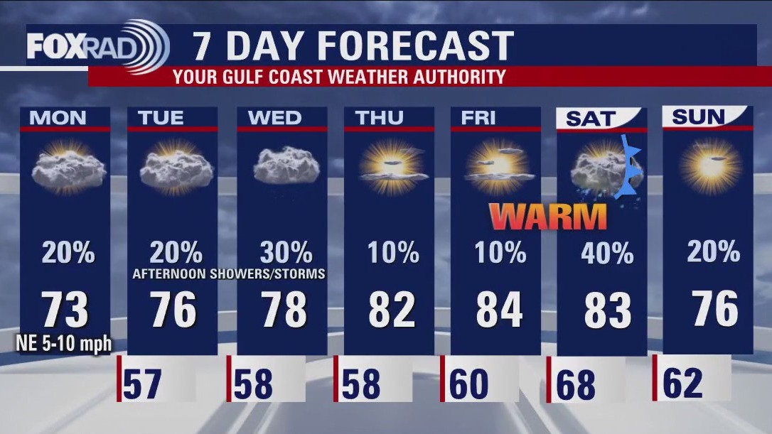
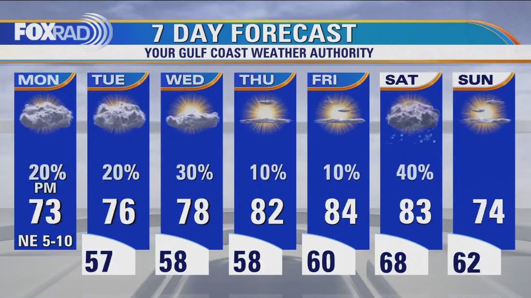
Monday evening weather forecast with Meteorologist Remeisha Shade
We are starting off the work week with mostly cloudy skies and mild temperatures in the 70s. Look for an isolated shower or storm this evening with the best chances west. Weather overnight should be pleasant with overnight lows near 60. Tuesday's weather pattern will be similar with a 20% chance for showers and storms and temperatures climbing to the 70s. By Wednesday, we are expecting a surface low to develop in the north-central Gulf of Mexico, just south of New Orleans. While it is not expected to become a tropical system, it could become subtropical and bring a big round of rain to the Louisiana Gulf coast. Fortunately, models project this low to stay to our SE which means we would be on the western side or drier side with no major impacts on Houston weather. There will be a slightly higher chance of showers and storms Wednesday (30%), especially for the eastern half of the area. By late week, we heat up ahead of our next cold front. Showers and some strong storms appear to be a good bet by Saturday evening with this next front. Look for widespread 80s Thursday through Saturday with cooler weather likely early next week.
We are starting off the work week with mostly cloudy skies and mild temperatures in the 70s. Look for an isolated shower or storm this evening with the best chances west. Weather overnight should be pleasant with overnight lows near 60. Tuesday's weather pattern will be similar with a 20% chance for showers and storms and temperatures climbing to the 70s. By Wednesday, we are expecting a surface low to develop in the north-central Gulf of Mexico, just south of New Orleans. While it is not expected to become a tropical system, it could become subtropical and bring a big round of rain to the Louisiana Gulf coast. Fortunately, models project this low to stay to our SE which means we would be on the western side or drier side with no major impacts on Houston weather. There will be a slightly higher chance of showers and storms Wednesday (30%), especially for the eastern half of the area. By late week, we heat up ahead of our next cold front. Showers and some strong storms appear to be a good bet by Saturday evening with this next front. Look for widespread 80s Thursday through Saturday with cooler weather likely early next week.

Monday afternoon weather forecast with Meteorologist John Dawson
This week's weather is a bit complicated, but overall will bring a chance for isolated afternoon storms with pleasant morning and afternoon temperatures. From Tuesday through Thursday, there is a chance for a small semi-tropical type area or low pressure in the Gulf - it's unlikely to have a significant impact on Texas, but could bring extra rain to Louisiana.
This week's weather is a bit complicated, but overall will bring a chance for isolated afternoon storms with pleasant morning and afternoon temperatures. From Tuesday through Thursday, there is a chance for a small semi-tropical type area or low pressure in the Gulf - it's unlikely to have a significant impact on Texas, but could bring extra rain to Louisiana.


Mondays with Mike: Climate change and home runs?
A new paper asserts that climate change is leading to more home runs being hit across Major League Baseball. Chief Meteorologist Mike Iscovitz thinks this paper is a foul ball.
A new paper asserts that climate change is leading to more home runs being hit across Major League Baseball. Chief Meteorologist Mike Iscovitz thinks this paper is a foul ball.

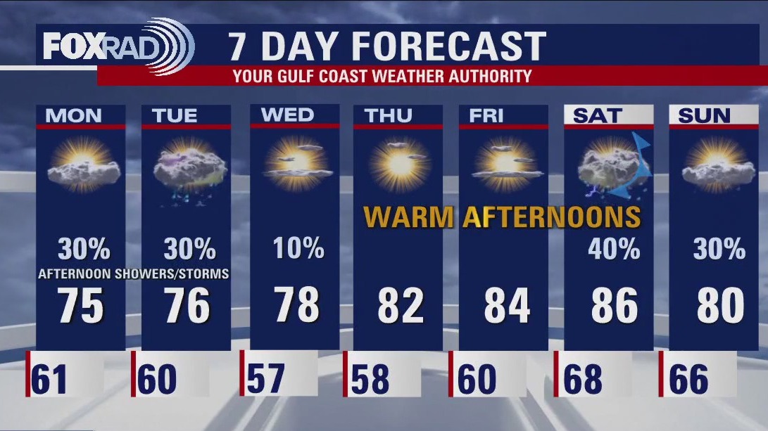
Houston weather: Pleasant temperatures Monday with a few afternoon storms possible
This week's weather is a bit complicated, but overall will bring a chance for isolated afternoon storms with pleasant morning and afternoon temperatures. From Tuesday through Thursday, there is a chance for a small semi-tropical type area or low pressure in the Gulf - it's unlikely to have a significant impact on Texas, but could bring extra rain to Louisiana.
This week's weather is a bit complicated, but overall will bring a chance for isolated afternoon storms with pleasant morning and afternoon temperatures. From Tuesday through Thursday, there is a chance for a small semi-tropical type area or low pressure in the Gulf - it's unlikely to have a significant impact on Texas, but could bring extra rain to Louisiana.

Sunday evening/Monday morning weather forecast
Scattered showers across the Houston area on Monday and Tuesday. Maybe an isolated downpour but if you see rain it won't be too intense. The end of the week for southeast Texas will be drier and warmer. Expect a cold front sometime next weekend to cool temps slightly and return rain to the forecast.
Scattered showers across the Houston area on Monday and Tuesday. Maybe an isolated downpour but if you see rain it won't be too intense. The end of the week for southeast Texas will be drier and warmer. Expect a cold front sometime next weekend to cool temps slightly and return rain to the forecast.