

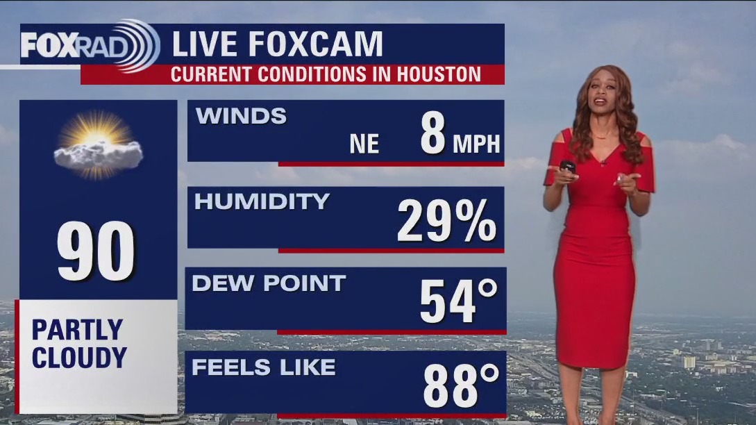

Houston weather: Sunny, partly cloudy Friday evening in the 90s
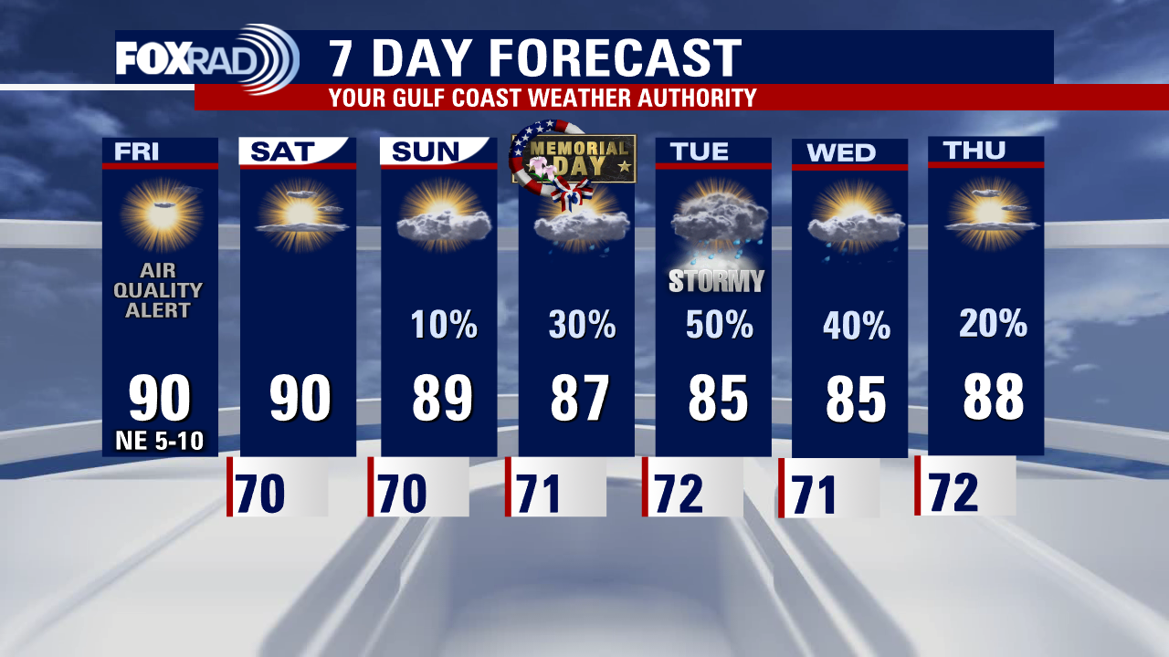
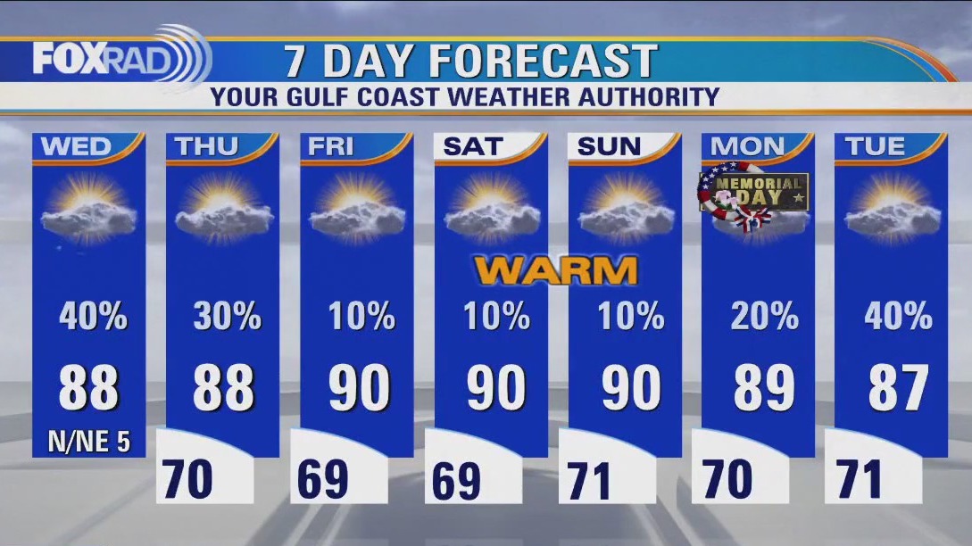
We've made it to the Memorial Day holiday weekend with fairly quiet weather expected for most of it. Once again, our Air Quality Alert has been extended through Saturday evening with higher levels of ozone in the atmosphere likely. If you are sensitive to poor air quality, try to limit outdoor time. Otherwise, expect only a 10% chance for rain Saturday and Sunday. Rain & storm chances increase to 30% for Memorial Day with more widespread heavy downpours looking more likely for Tuesday. Remember to limit sun exposure this weekend & use sunscreen with the UV index expected to remain very high. Temperatures remain seasonable for the next several days. To keep track of the holiday weekend weather, grab the FOX 26 weather app from the app store to have radar and alerts on the go!
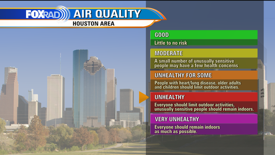

Houston Air Quality: What to know about ozone season, pollutants
Houston is currently in the midst of ozone season which runs until September 30. How does it impact the air quality in Houston?

Air Quality Alert continues for ozone, gradually increasing cloud cover and rain chances next week
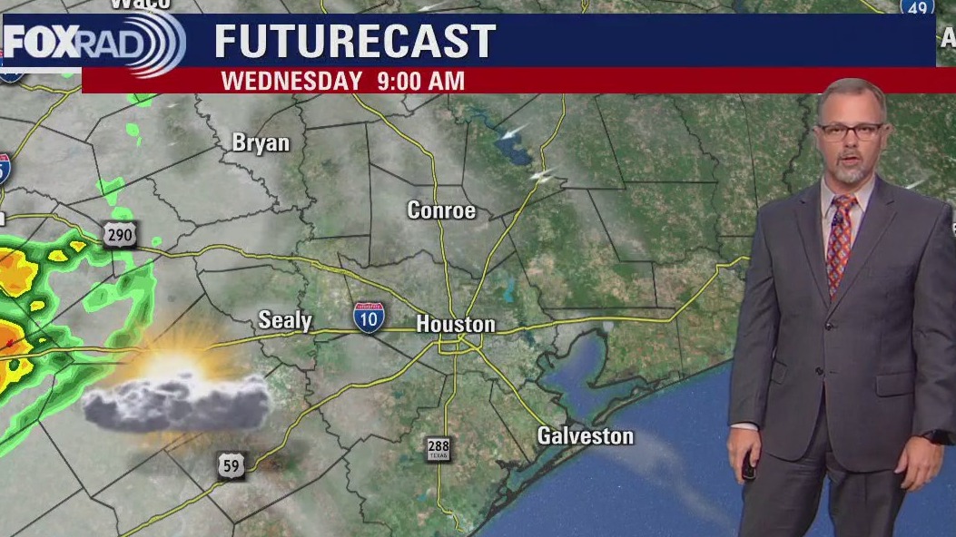
Another sunny, dry day means another air quality alert for ozone. If you're driving to West Texas today, be on the lookout for strong to severe storms. Spending the weekend locally? Look for gradually increasing cloud cover and rain chances. By middle of next week, locally heavy rainfall will be a possibility in the Tuesday-Wednesday time frame.


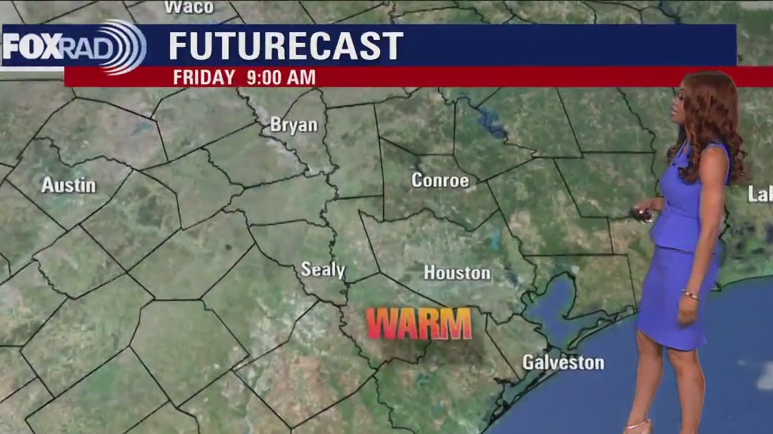
Houston weather: Mild Friday morning, then sunny and warm
Heading into a long Memorial Day holiday weekend, expect some seasonably warm weather with mostly sunny skies and a slight chance for a late-day storm. Highs through Sunday should approach 90, which is normal for this time of year. Humidity will be fairly comfortable today, but should climb by Sunday. Rain chances increase by Memorial Day and into the middle of next week.

Houston weather: Weather pattern looks to remain quiet, isolated rain possible
We are getting closer and closer to our holiday weekend! It looks like the weather pattern will remain on the quiet side with just isolated rain possible in the afternoon and near average heat for late May. Look for only a 10% chance for rain Friday through Sunday with rain chances increasing slightly to 20% for Memorial Day on Monday. Better storms chances are expected to return after the Memorial Day holiday. Temperatures are near normal for the next week with highs near 90 and overnight lows near 70.


Typhoon Mawar leaves Guam with widespread damage after raking US territory with 100+ mph winds
Super Typhoon Mawar is now the strongest tropical cyclone of 2023 so far. According to data from Colorado State University, Super Typhoon Mawar's 175 mph winds made it stronger than Freddy and Mocha, which roamed the Indian Ocean earlier this year.

Houston weather: Steamy, dry Thursday afternoon in the 80s
Daytime highs will hover near 90 with lots of sunshine over the course of the next week. Rain chances are also slim at best through Monday. Great news for those with outdoor plans for the long weekend, bad news for our poor air quality as with light winds there's nothing to wash it away or mix it out until middle of next week.

Houston weather: Warm humid start Thursday, mostly sunny afternoon
Our air quality alert for ozone/smoke has been extended through this evening. Heading into the long weekend, we'll be mainly sunny, quiet and warm. Rain chances aren't zero, but we won't see more than an isolated shower or storm until early next week. A few showers may be present late on Memorial Day Monday, with scattered storms returning to the mix by middle of next week.

Houston weather: Few showers, storms possible on Thursday
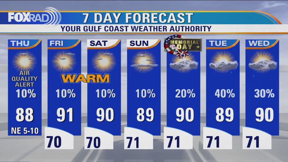
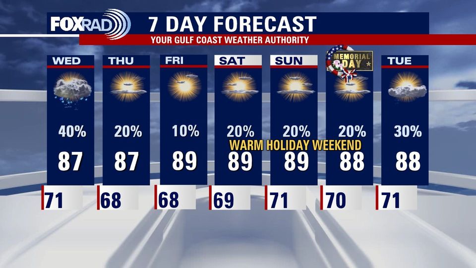
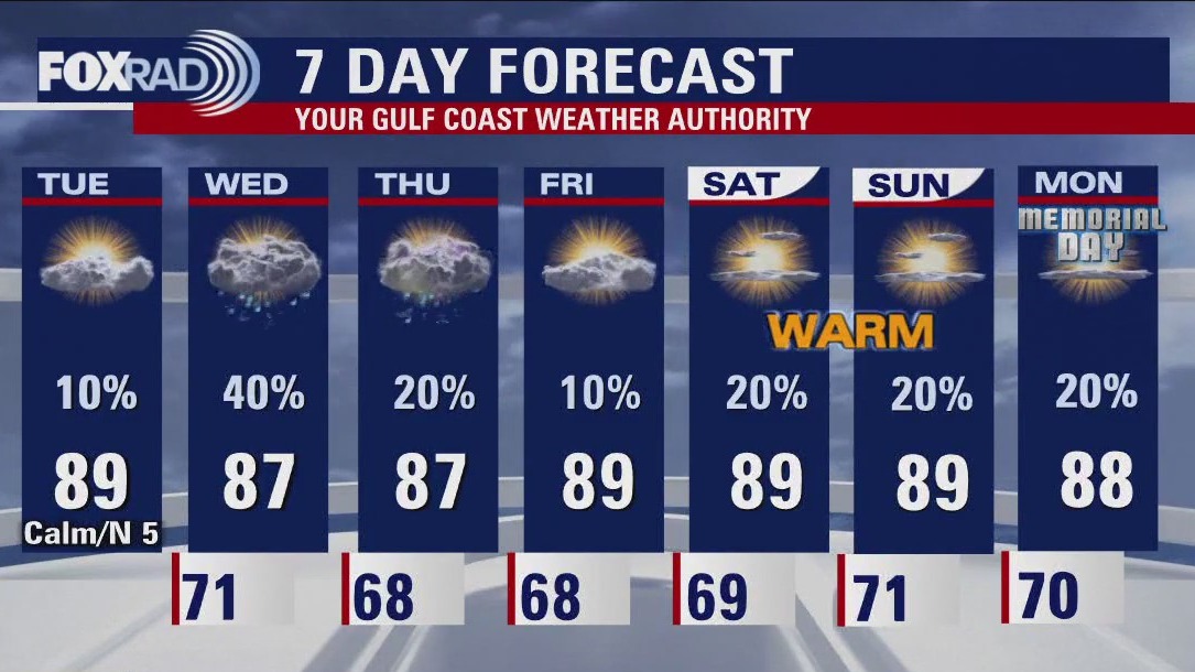
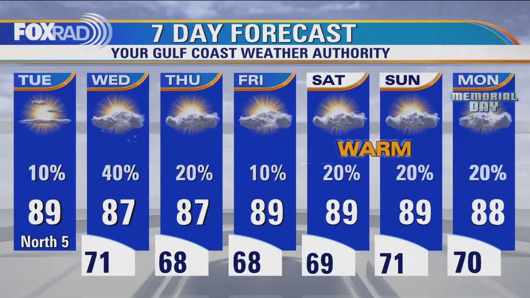
We repeat the pattern of one or two storms popping up on Thursday and Friday from the afternoon to just shortly after sunset. Rain chances are very low for the holiday weekend at 10% Saturday - Sunday and 20% for Memorial Day. Rain chances jump back up to 30-40% for Tuesday and Wednesday. Temperatures stay near 70 at night and near 90 during the mid-late afternoon for the next week.


National Weather Service releases preliminary information regarding Tuesday's severe weather
National Weather Service meteorologists provided some preliminary information about Tuesday afternoon's severe weather that moved through the Huntsville and Willis area.

Houston weather: Air quality warning extended, warm temps Wednesday evening
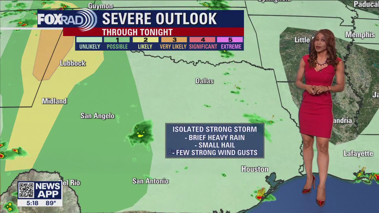
One or two storms may still pop up through early tonight across SE Texas. The threat for severe weather is very low. But we still cannot rule out an isolated strong wind gust and some large hail along with brief heavy rain. Storms should fade after 10 pm and the storm chance is only around 20% tonight. We repeat this pattern Thursday and Friday with just a few storms possible from the afternoon to just shortly after sunset. Rain chances are very low for the holiday weekend at 10% Saturday - Sunday and 20% for Memorial Day. Rain chances jump back up to 30-40% for Tuesday and Wednesday. Temperatures stay near 70 at night and near 90 during the mid-late afternoon for the next week. Remember to download the FOX 26 Weather App to keep track of the latest watches, warnings and advisories that may be issued for the area.
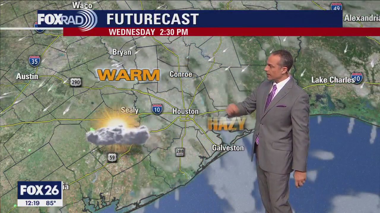

Houston weather: Warm, hazy Wednesday afternoon in the 70s
Isolated late day storms are possible today with otherwise warm and hazy weather. Tomorrow brings a chance for some afternoon storms, then Friday through the Memorial Day weekend, expect late May heat with a few daily showers.

Houston weather: Isolated late day storms possible Wednesday
Isolated late day storms are possible today with otherwise warm and hazy weather. Tomorrow brings a chance for some afternoon storms. Then Friday through the Memorial Day weekend, expect late May heat with a few daily showers.

Houston weather: More storms possible on Wednesday
Look for a round or two of storms on Wednesday across Southeast Texas. The typical end of May pattern should be in place for the rest of the week and into the holiday weekend.

Houston Weather: More storms expected Wednesday after unexpected severe weather Tuesday afternoon
Look for a round or two of storms on Wednesday across Southeast Texas. The typical end-of-May pattern should be in place for the rest of the week and into the holiday weekend.


Reports of damage from severe weather in Huntsville
We?ve been getting some reports of damage in the Huntsville area, FOX 26?s Natalie Hee went out there to survey the area.

Houston Weather: Mostly sunny and warm Tuesday with highs near 90
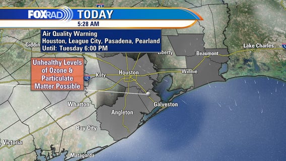
Today is going to include more sunshine and warmer air than yesterday, but there is one concern and that is air quality. Light winds and sunshine could allow for unhealthy levels of both ozone and particulate matter (dust and/or smoke). Aside from that, look for scattered showers and storms tomorrow and a pretty typical late May pattern through Memorial Day.

Houston weather: What does Air Quality Alert mean? What's in the air?
The Houston area is under an Air Quality Alert today. So, what does that mean, and what exactly is in the air?

Houston weather: Mostly sunny and warm Tuesday
Today is going to include more sunshine and warmer air than yesterday, but there is one concern and that is air quality. Light winds and sunshine could allow for unhealthy levels of both ozone and particulate matter (dust and/or smoke). Aside from that, look for scattered showers and storms tomorrow and a pretty typical late May pattern through Memorial Day.


Typhoon Mawar continues to intensify as it barrels towards US territory of Guam
Typhoon Warnings are in effect for Guam and Rota, and forecasters say damaging winds of 39 mph are expected Tuesday evening, with typhoon-force winds of 74 mph or higher expected by Wednesday morning.