

Tracking Tropical Storm Laura, Tropical Storm Marco
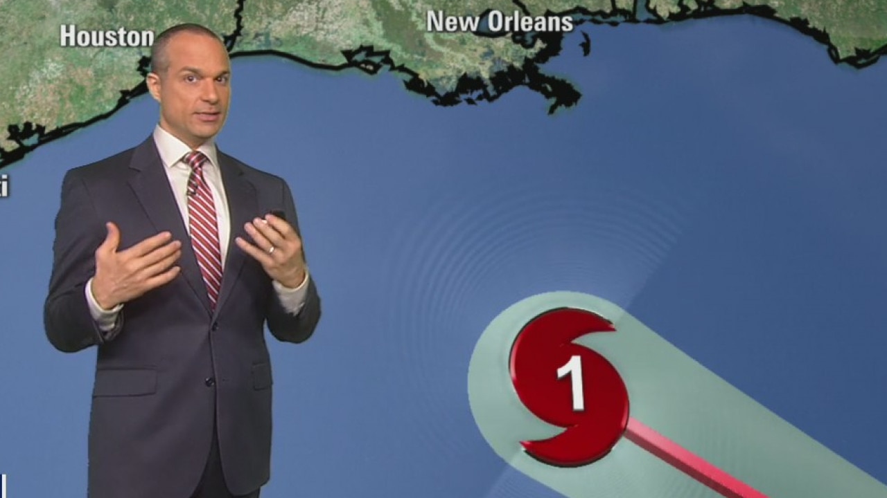
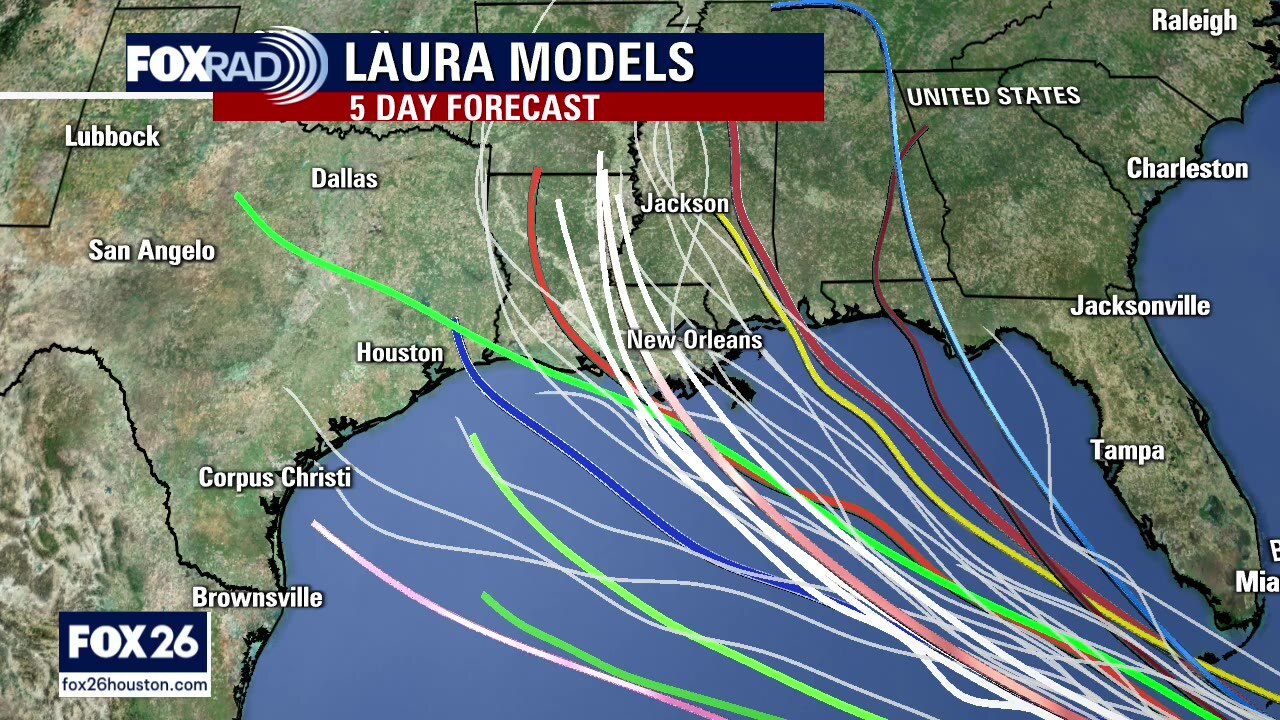
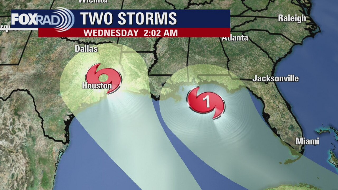
Overnight, Marco got much weaker and Laura got a bit stronger. Marco is expected to move our way as a tropical depression and bring some rain Tuesday and early Wednesday. By that time, we will be anxiously watching what will likely be Hurricane Laura. The latest models and NHC forecast track haven?t changed much - the focus is still near the state line of Texas and Louisiana. Any small changes to the west or east will have a large effect on the severity of our weather. At this point, prepare for rain, wind and especially coastal flooding Wednesday and Thursday. Coastal evacuations might be necessary.
Overnight, Marco got much weaker and Laura got a bit stronger. Marco is expected to move our way as a tropical depression and bring some rain Tuesday and early Wednesday. By that time, we will be anxiously watching what will likely be Hurricane Laura. The latest models and NHC forecast track haven?t changed much - the focus is still near the state line of Texas and Louisiana. Any small changes to the west or east will have a large effect on the severity of our weather. At this point, prepare for rain, wind and especially coastal flooding Wednesday and Thursday. Coastal evacuations might be necessary.
Update on Tropical Storm Marco and Tropical Storm Laura
Overnight, Marco got much weaker and Laura got a bit stronger. Marco is expected to move our way as a tropical depression and bring some rain Tuesday and early Wednesday. By that time, we will be anxiously watching what will likely be Hurricane Laura. The latest models and NHC forecast track haven?t changed much - the focus is still near the state line of Texas and Louisiana. Any small changes to the west or east will have a large effect on the severity of our weather. At this point, prepare for rain, wind and especially coastal flooding Wednesday and Thursday. Coastal evacuations might be necessary.
Overnight, Marco got much weaker and Laura got a bit stronger. Marco is expected to move our way as a tropical depression and bring some rain Tuesday and early Wednesday. By that time, we will be anxiously watching what will likely be Hurricane Laura. The latest models and NHC forecast track haven?t changed much - the focus is still near the state line of Texas and Louisiana. Any small changes to the west or east will have a large effect on the severity of our weather. At this point, prepare for rain, wind and especially coastal flooding Wednesday and Thursday. Coastal evacuations might be necessary.
Sunday night tropical forecast/Monday morning weather forecast
FOX 26 Chief Meteorologist Dr. Jim Siebert and FOX 26 Meteorologist John Dawson have the latest on Hurricane Marco, Tropical Storm Laura and the forecast for the Houston area.
FOX 26 Chief Meteorologist Dr. Jim Siebert and FOX 26 Meteorologist John Dawson have the latest on Hurricane Marco, Tropical Storm Laura and the forecast for the Houston area.
Sunday evening tropics update/weather forecast
FOX 26 Chief Meteorologist Dr. Jim Siebert and FOX 26 Meteorologist John Dawson have the latest on Hurricane Marco, Tropical Storm Laura and the forecast for the Houston area.
FOX 26 Chief Meteorologist Dr. Jim Siebert and FOX 26 Meteorologist John Dawson have the latest on Hurricane Marco, Tropical Storm Laura and the forecast for the Houston area.
Houston-area weather forecast 8-23
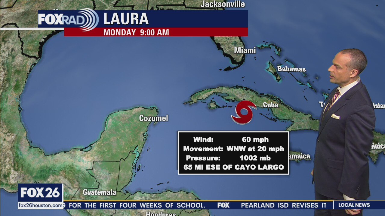
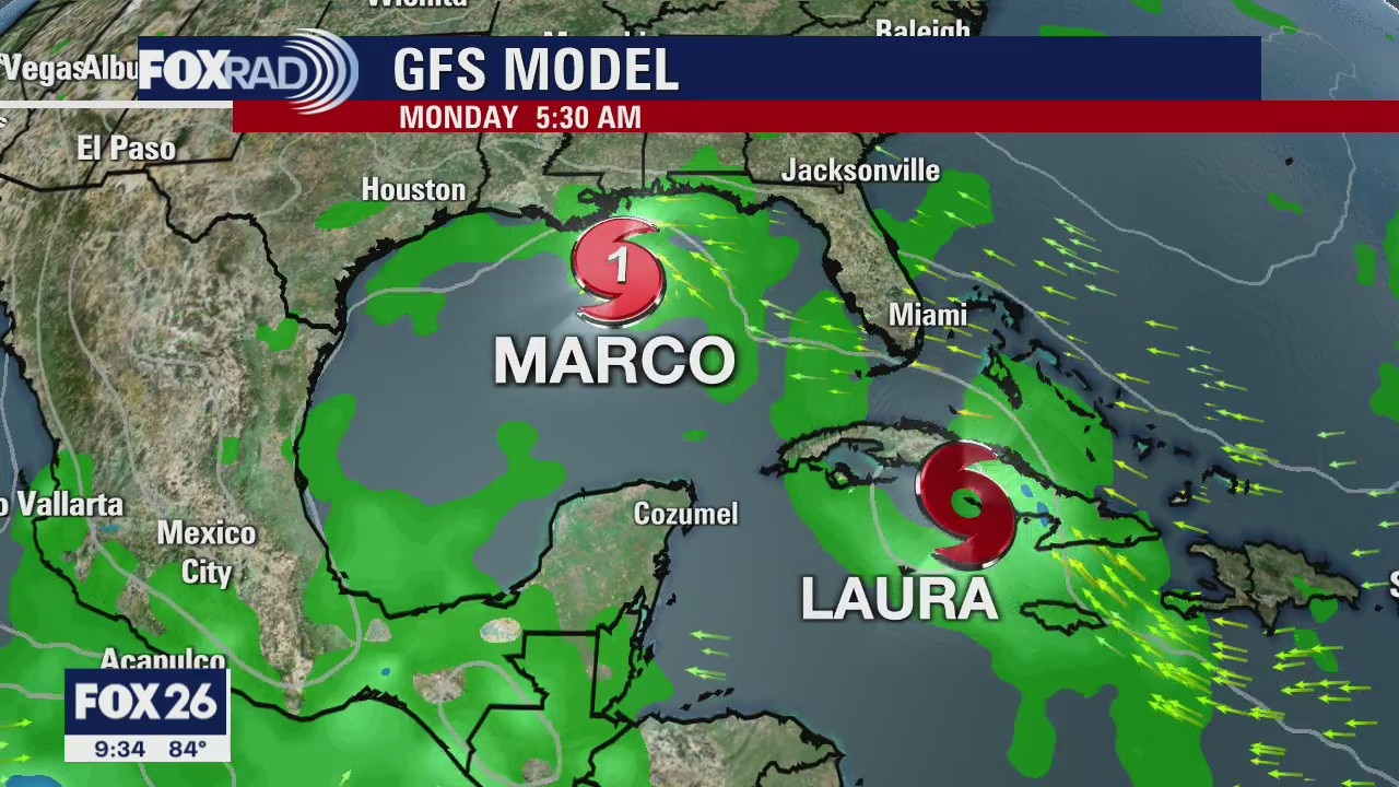
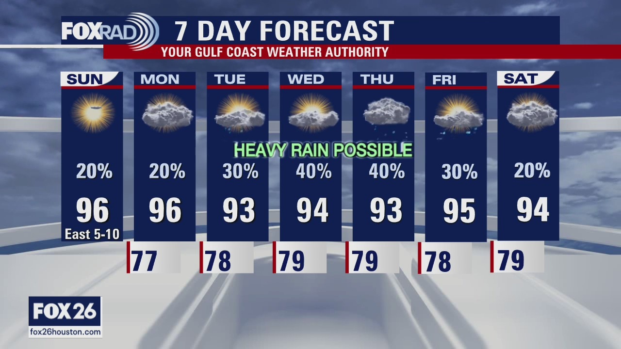
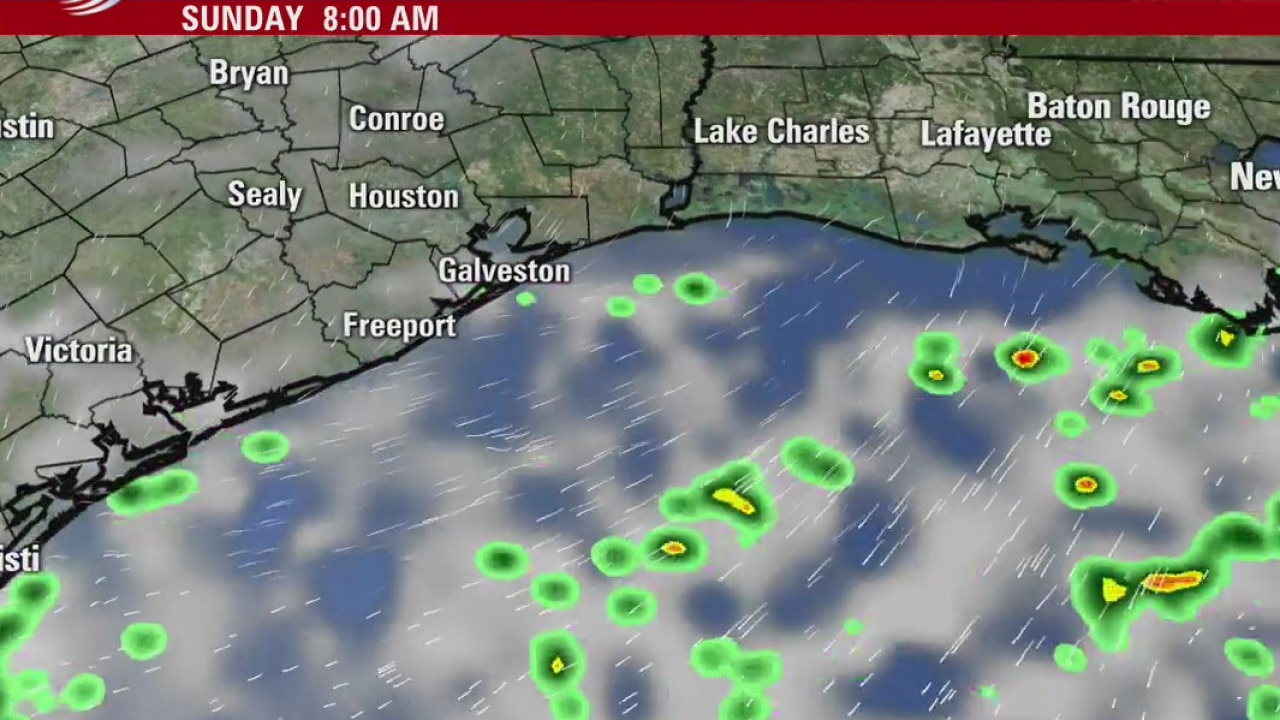
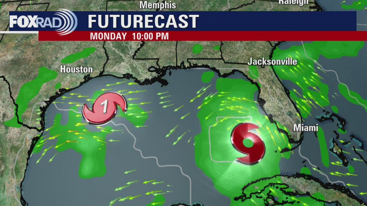
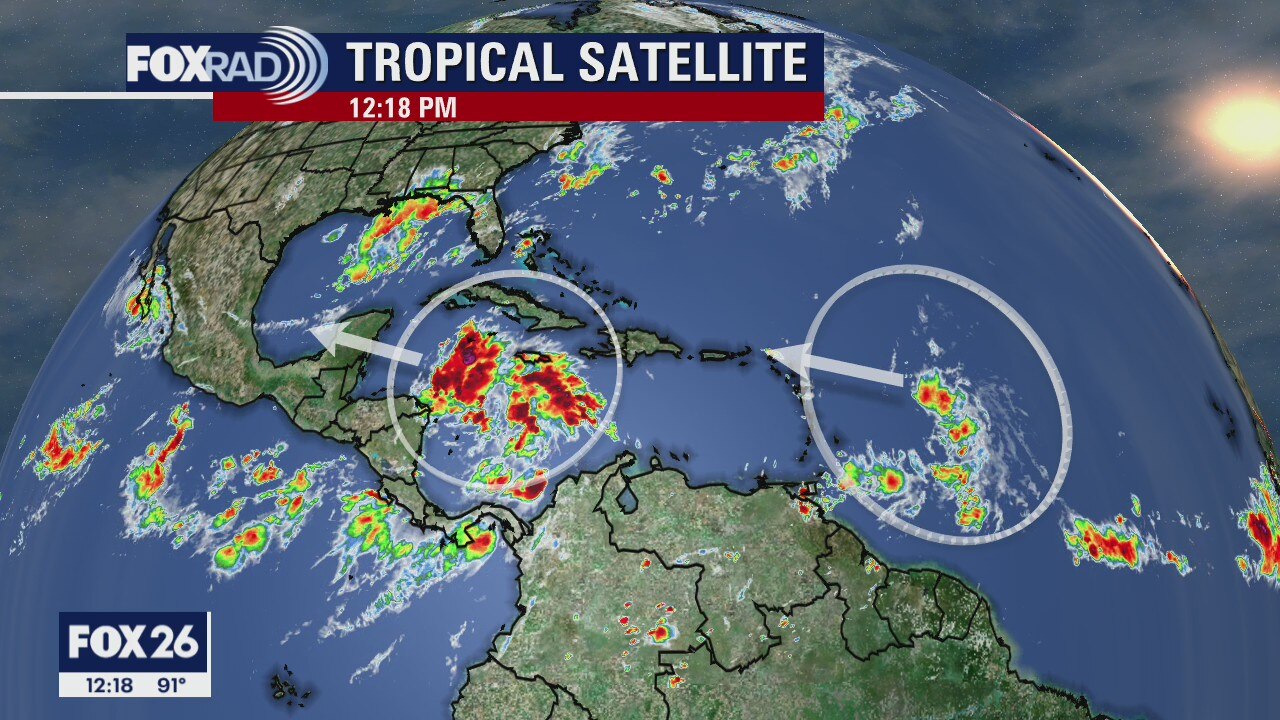
Warm weather on Sunday with a few showers possible this afternoon. Our attention, however, is focused on a complex forecast over the next few days for the Houston-area. Marco, forecast to become a hurricane later today, will likely make landfall along the Louisiana coastline on Monday evening with very little negative impact to our weather in Houston. Not far behind Marco is Laura, which is showing signs of strengthening this morning over the Dominican Republic and Haiti. Once Laura emerges in the Gulf on Monday, we should have higher confidence where the ultimate track will take the storm. Part of Houston is in Laura's cone of uncertainty, but there does remain a high level of uncertainty as it moves over the rugged terrain of Hispaniola and Cuba. The current forecast has Laura making landfall late Wednesday or early Thursday morning either in Texas or Louisiana. This is an evolving forecast so be sure to check back in throughout the day.
Warm weather on Sunday with a few showers possible this afternoon. Our attention, however, is focused on a complex forecast over the next few days for the Houston-area. Marco, forecast to become a hurricane later today, will likely make landfall along the Louisiana coastline on Monday evening with very little negative impact to our weather in Houston. Not far behind Marco is Laura, which is showing signs of strengthening this morning over the Dominican Republic and Haiti. Once Laura emerges in the Gulf on Monday, we should have higher confidence where the ultimate track will take the storm. Part of Houston is in Laura's cone of uncertainty, but there does remain a high level of uncertainty as it moves over the rugged terrain of Hispaniola and Cuba. The current forecast has Laura making landfall late Wednesday or early Thursday morning either in Texas or Louisiana. This is an evolving forecast so be sure to check back in throughout the day.
Sunday morning weather forecast
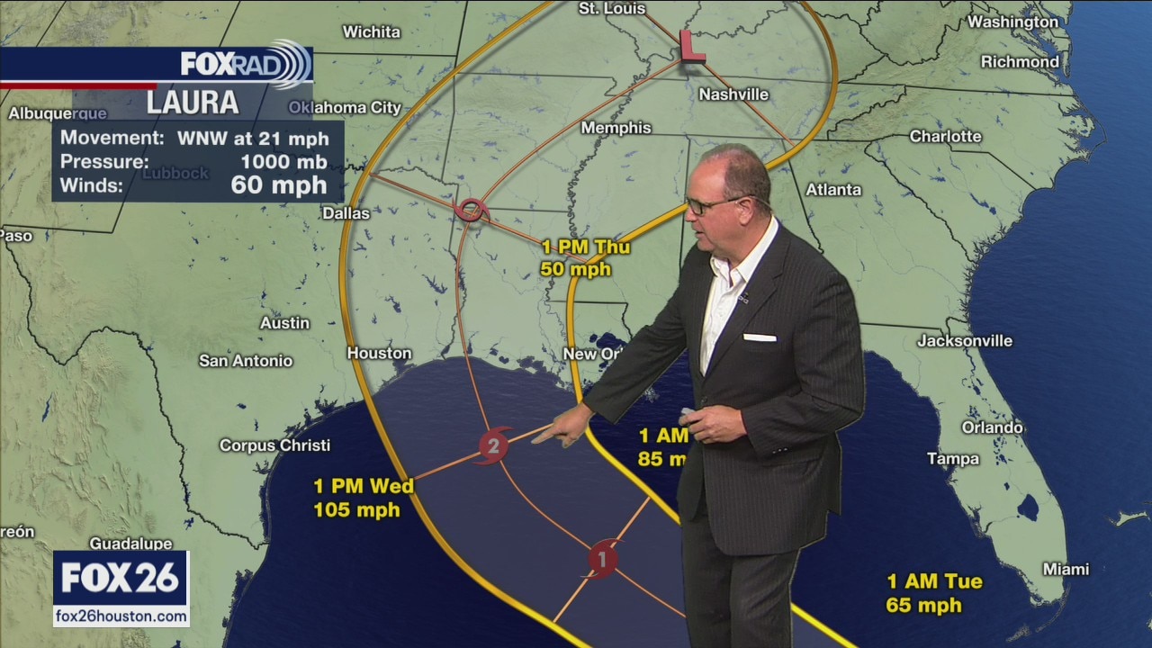
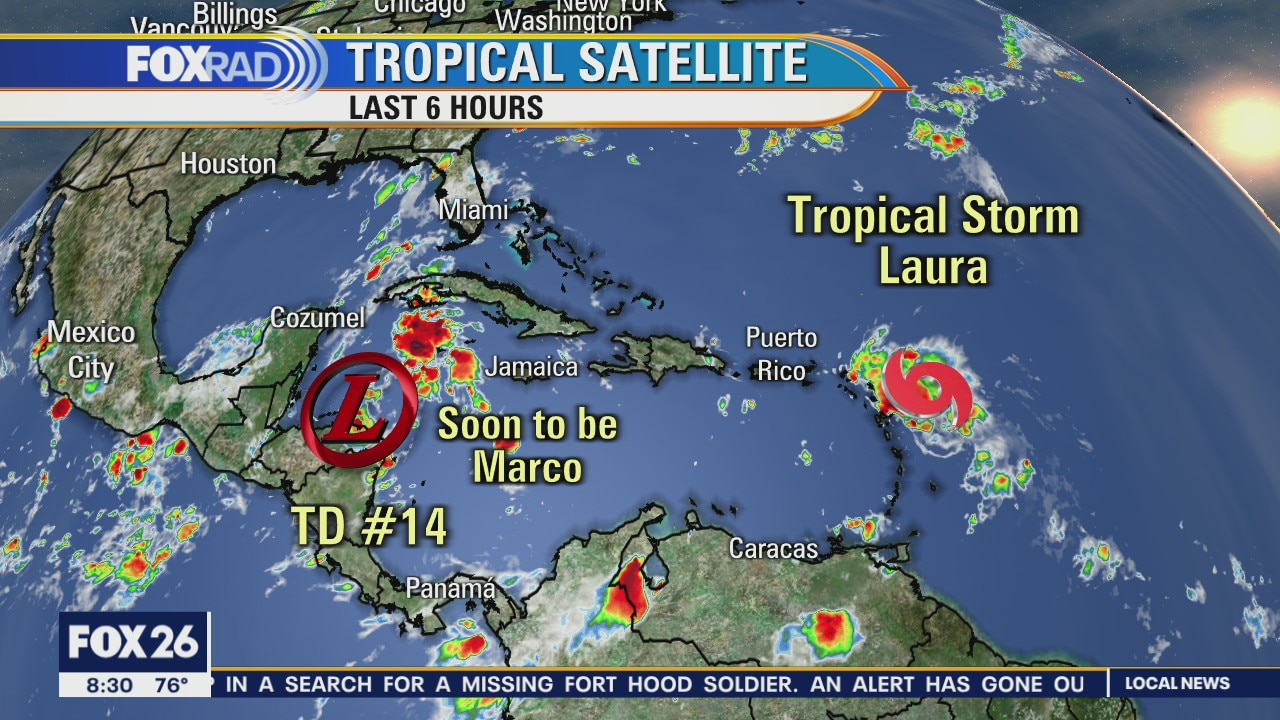
We are still watching the Gulf but feeling better about Marco this evening. Laura looks to follow Marco into Louisiana but still has some uncertainty in its forecast. Keeping rain chances conservative right now holding everything in line with tracks from the National Hurricane Center.
We are still watching the Gulf but feeling better about Marco this evening. Laura looks to follow Marco into Louisiana but still has some uncertainty in its forecast. Keeping rain chances conservative right now holding everything in line with tracks from the National Hurricane Center.
Saturday morning weather
Update on the tropics and the weekend weather forecast as well as a look ahead at the coming week.
Update on the tropics and the weekend weather forecast as well as a look ahead at the coming week.
Saturday morning weather forecast
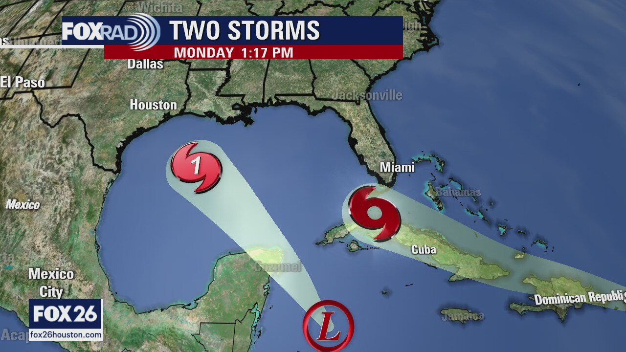
The weekend should be quiet and warm for us here in Houston. Monday-Wednesday is all about Tropical Storm Marco. Still lots of questions to be answered but it does seem like we will be seeing some rain and winds from this storm
The weekend should be quiet and warm for us here in Houston. Monday-Wednesday is all about Tropical Storm Marco. Still lots of questions to be answered but it does seem like we will be seeing some rain and winds from this storm
Tropical weather update
The weekend should be quiet and warm for us here in Houston. Monday-Wednesday is all about TD#4 (Marco). There are still lots of questions to be answered but it does seem like we will be seeing some rain and winds from this storm.
The weekend should be quiet and warm for us here in Houston. Monday-Wednesday is all about TD#4 (Marco). There are still lots of questions to be answered but it does seem like we will be seeing some rain and winds from this storm.
Tropical Weather Forecast
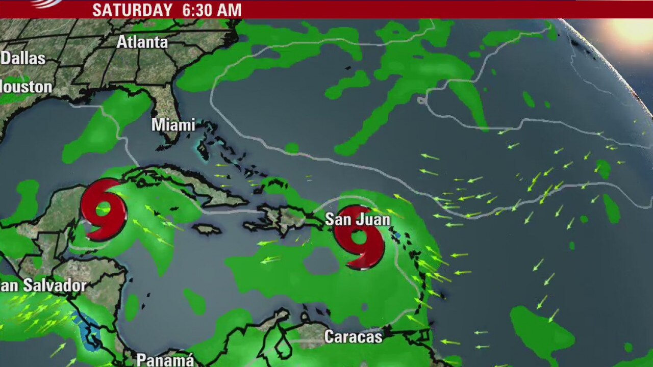
Another unprecedented event is about to happen. It?s rather fitting for 2020. Two hurricanes in the Gulf at the same time. It?s time to put our hurricane plans into action. Tues night looks to be landfall for Hurricane Marco in SE Texas. Be calm, be alert, and be wise.
Another unprecedented event is about to happen. It?s rather fitting for 2020. Two hurricanes in the Gulf at the same time. It?s time to put our hurricane plans into action. Tues night looks to be landfall for Hurricane Marco in SE Texas. Be calm, be alert, and be wise.
Tropical Weather Forecast
Meteorologist Mike Iscovitz has the latest
Meteorologist Mike Iscovitz has the latest
Friday weather forecast
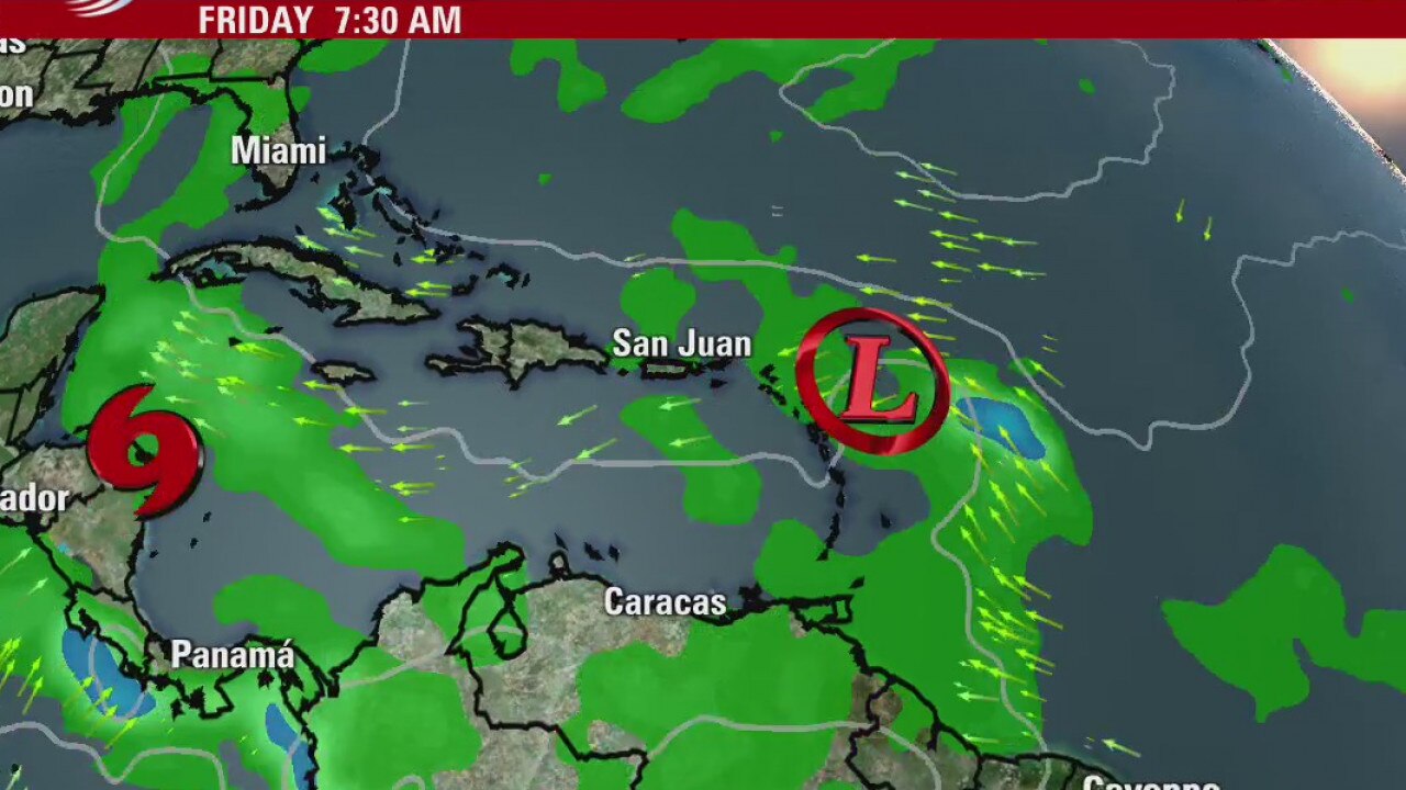
As we watch and wait for developments in the tropics, keep an eye out for afternoon storms today through Sunday with about a 20% chance each day. Highs will run in the mid 90s. Over the weekend, we will get more certainty about the strength and track of TD #14 as it becomes a tropical storm and possibly a hurricane. For now, plan on rain and coastal flooding by Tuesday.
As we watch and wait for developments in the tropics, keep an eye out for afternoon storms today through Sunday with about a 20% chance each day. Highs will run in the mid 90s. Over the weekend, we will get more certainty about the strength and track of TD #14 as it becomes a tropical storm and possibly a hurricane. For now, plan on rain and coastal flooding by Tuesday.
Friday weather forecast
As we watch and wait for developments in the tropics, keep an eye out for afternoon storms today through Sunday with about a 20% chance each day. Highs will run in the mid 90s. Over the weekend, we will get more certainty about the strength and track of TD #14 as it becomes a tropical storm and possibly a hurricane. For now, plan on rain and coastal flooding by Tuesday.
As we watch and wait for developments in the tropics, keep an eye out for afternoon storms today through Sunday with about a 20% chance each day. Highs will run in the mid 90s. Over the weekend, we will get more certainty about the strength and track of TD #14 as it becomes a tropical storm and possibly a hurricane. For now, plan on rain and coastal flooding by Tuesday.
Friday morning weather forecast
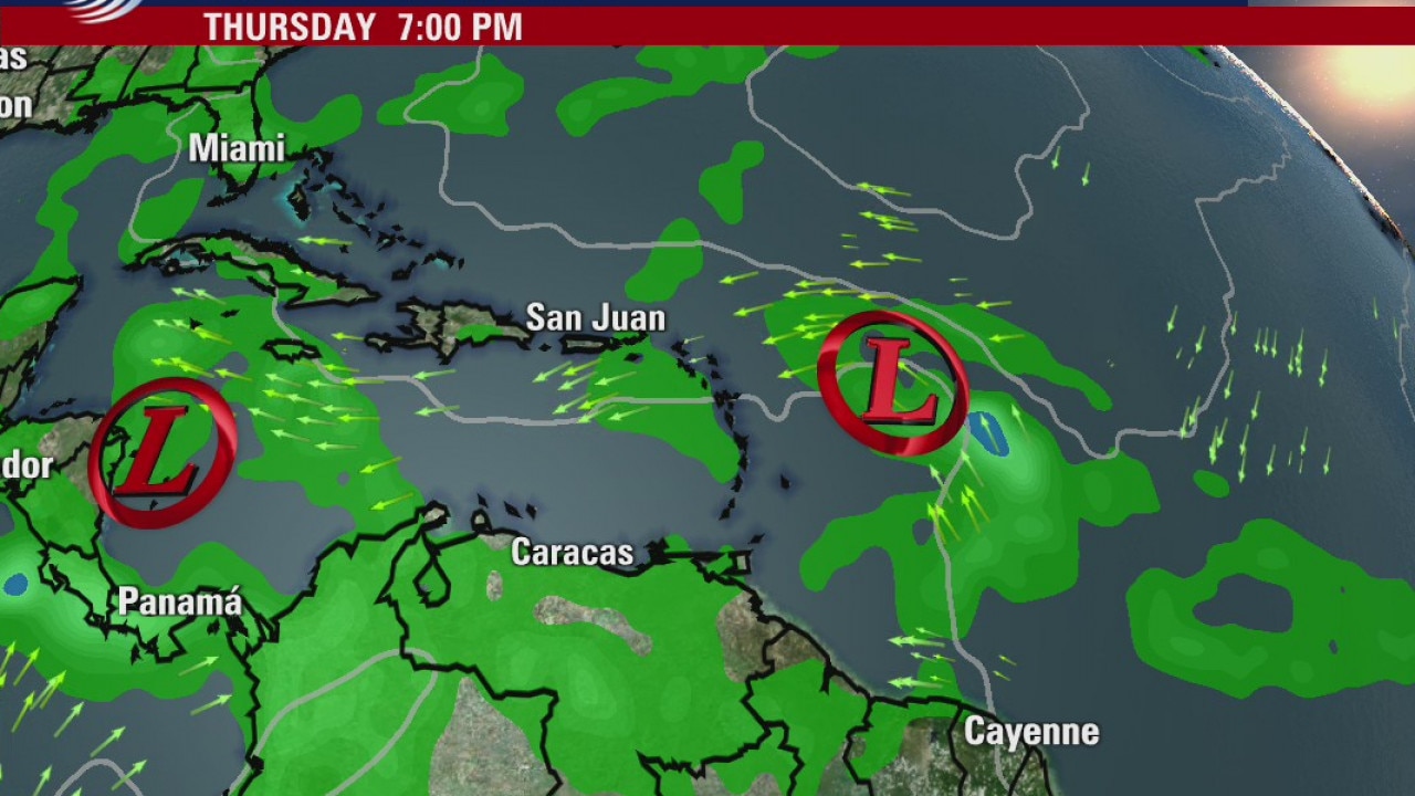
All eyes on the tropics as there are two tropical depressions headed towards the Gulf of Mexico. These systems could start impacting Houston on Monday. But for the rest of this week and through most of the weekend, we are expecting quiet warm August days in Southeast Texas. Stay connected over the weekend to track the soon to be tropical storms heading into the Gulf.
All eyes on the tropics as there are two tropical depressions headed towards the Gulf of Mexico. These systems could start impacting Houston on Monday. But for the rest of this week and through most of the weekend, we are expecting quiet warm August days in Southeast Texas. Stay connected over the weekend to track the soon to be tropical storms heading into the Gulf.
Thursday evening weather forecast
All eyes on the tropics as there are two tropical depressions headed towards the Gulf of Mexico. These systems could start impacting Houston on Monday. But for the rest of this week and through most of the weekend, we are expecting quiet warm August days in Southeast Texas. Stay connected over the weekend to track the soon to be tropical storms heading into the Gulf.
All eyes on the tropics as there are two tropical depressions headed towards the Gulf of Mexico. These systems could start impacting Houston on Monday. But for the rest of this week and through most of the weekend, we are expecting quiet warm August days in Southeast Texas. Stay connected over the weekend to track the soon to be tropical storms heading into the Gulf.
Thursday weather forecast
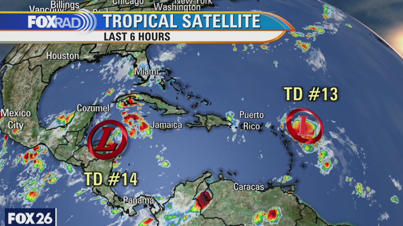
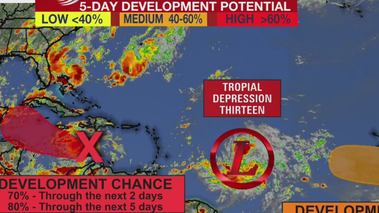
Tropical depression 14 has formed in the Caribbean and the first forecast from the National Hurricane Center does point the system at the Houston area. It?s important to remember that this forecast is likely to change, so just stay aware over the next few days. The Hurricane Center will issue new forecasts at 4 and 10 am and pm.
Tropical depression 14 has formed in the Caribbean and the first forecast from the National Hurricane Center does point the system at the Houston area. It?s important to remember that this forecast is likely to change, so just stay aware over the next few days. The Hurricane Center will issue new forecasts at 4 and 10 am and pm.
Thursday weather forecast
Pleasant this morning, then hit and dry with coastal storms possible by afternoon. Highs in the mid to upper 90s.
Pleasant this morning, then hit and dry with coastal storms possible by afternoon. Highs in the mid to upper 90s.
Thursday morning weather forecast
We'll have several days to keep an eye on the Tropics. Look for sunny and dry days through the the end of the week. Humidity will return to the normal August levels for Houston this weekend. Next week is all about the Tropical activity in the Gulf of Mexico. Too early to say exactly what to expect. Stay connected with FOX26 over the weekend!
We'll have several days to keep an eye on the Tropics. Look for sunny and dry days through the the end of the week. Humidity will return to the normal August levels for Houston this weekend. Next week is all about the Tropical activity in the Gulf of Mexico. Too early to say exactly what to expect. Stay connected with FOX26 over the weekend!
Wednesday evening weather forecast
We'll have several days to keep an eye on the Tropics. Look for sunny and dry days through the the end of the week. Humidity will return to the normal August levels for Houston this weekend. Next week is all about the Tropical activity in the Gulf of Mexico. Too early to say exactly what to expect. Stay connected with FOX26 over the weekend!
We'll have several days to keep an eye on the Tropics. Look for sunny and dry days through the the end of the week. Humidity will return to the normal August levels for Houston this weekend. Next week is all about the Tropical activity in the Gulf of Mexico. Too early to say exactly what to expect. Stay connected with FOX26 over the weekend!
Wednesday weather forecast
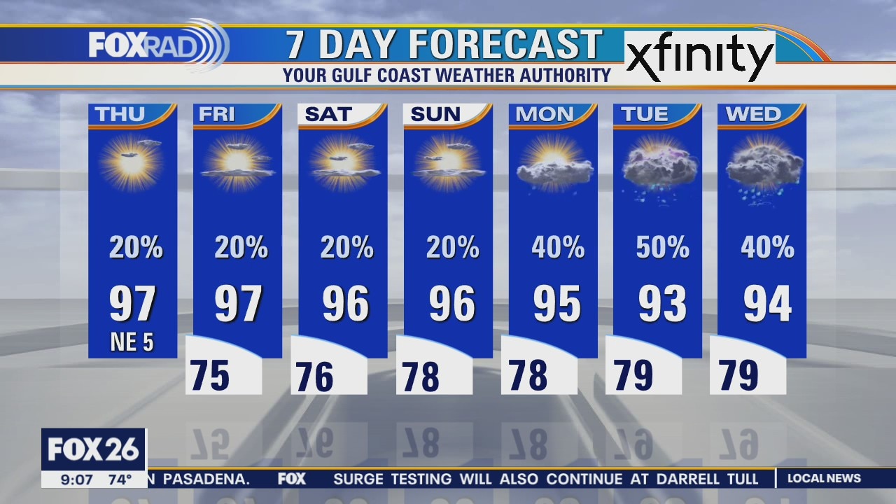
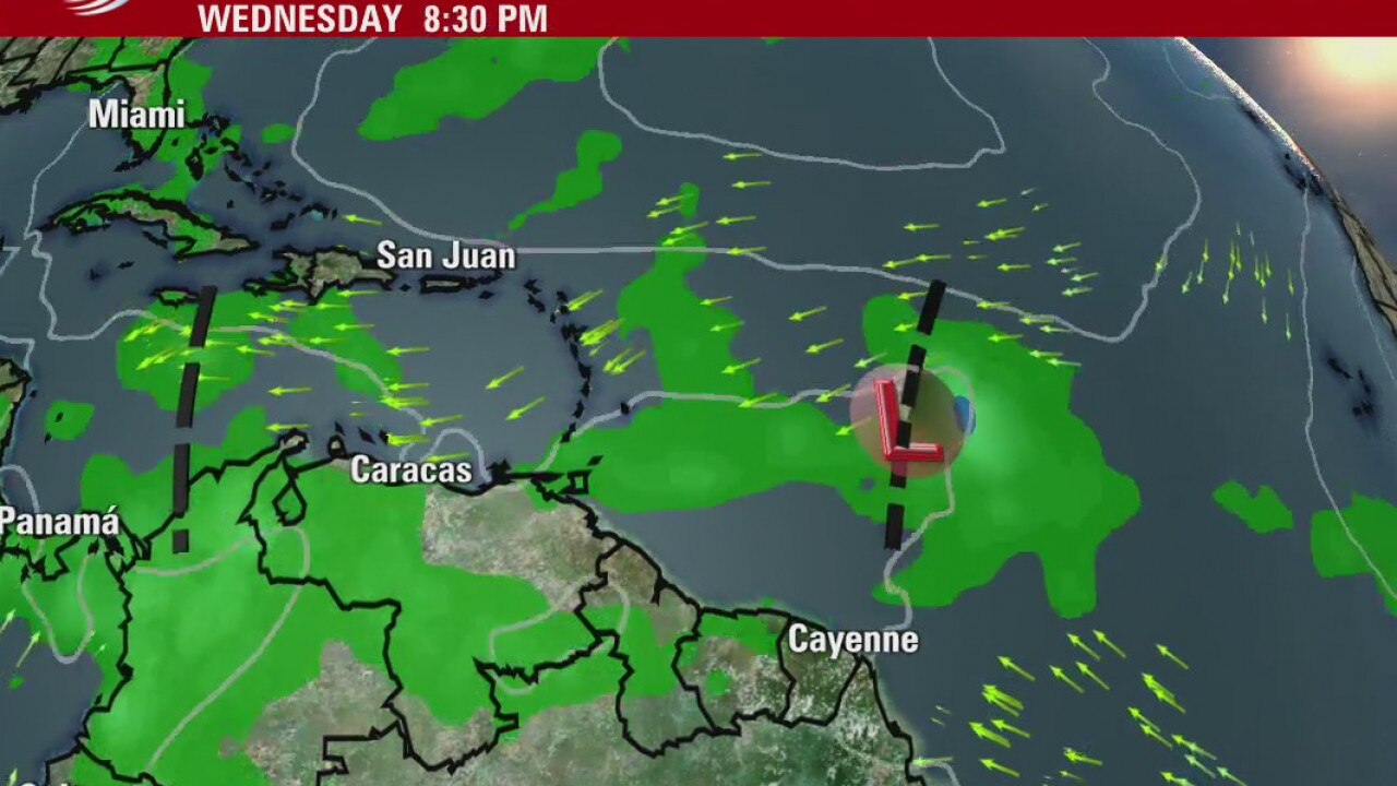
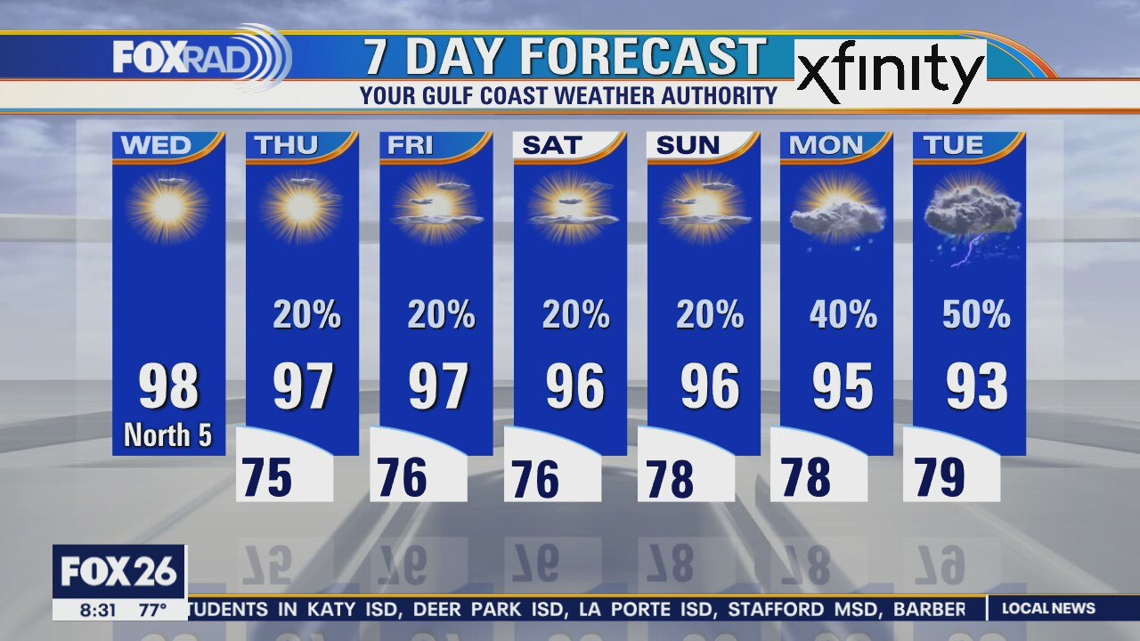
Our weather will be sunny, hot and dry today with a slim rain chance near the coast. The rest of the week will feature normal August warmth with highs in the mid 90s. Action is heating up on the tropics with two tropical waves. A wave in the Caribbean could bring us some rain early next week and a second, larger one in the Atlantic will likely become a tropical depression or storm today.
Our weather will be sunny, hot and dry today with a slim rain chance near the coast. The rest of the week will feature normal August warmth with highs in the mid 90s. Action is heating up on the tropics with two tropical waves. A wave in the Caribbean could bring us some rain early next week and a second, larger one in the Atlantic will likely become a tropical depression or storm today.